- Clearlake, California
-
City of Clearlake — City — Location in Lake County and the state of California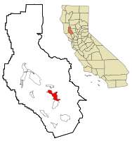
Coordinates: 38°57′30″N 122°37′35″W / 38.95833°N 122.62639°WCoordinates: 38°57′30″N 122°37′35″W / 38.95833°N 122.62639°W Country  United States
State  California
County Lake Area[1] - Total 10.581 sq mi (27.404 km2) - Land 10.129 sq mi (26.234 km2) - Water 0.452 sq mi (1.170 km2) 4.27% Elevation[2] 1,417 ft (432 m) Population (2010) - Total 15,250 - Density 1,441.3/sq mi (556.5/km2) Time zone Pacific (PST) (UTC-8) - Summer (DST) PDT (UTC-7) ZIP code 95422 Area code(s) 707 FIPS code 06-13945 GNIS feature ID 1657240 Clearlake is a city located in Lake County, California.[2] Clearlake is located 4.5 miles (7.2 km) north-northwest of Lower Lake,[3] at an elevation of 1417 feet (432 m).[2] As of the 2010 census, the city had a total population of 15,250, up from 13,142 at the 2000 census.
Contents
Geography
Clearlake is located at 38°57'30" North, 122°37'35" West.[2]
According to the United States Census Bureau, the city has a total area of 10.6 square miles (27 km2), of which, 10.1 square miles (26 km2) of it is land and 0.5 square miles (1.3 km2) of it is water. The total area is 4.27% water.
Demographics
2010
The 2010 United States Census[4] reported that Clearlake had a population of 15,250. The population density was 1,441.3 people per square mile (556.5/km²). The racial makeup of Clearlake was 11,262 (73.8%) White, 614 (4.0%) African American, 400 (2.6%) Native American, 161 (1.1%) Asian, 27 (0.2%) Pacific Islander, 1,805 (11.8%) from other races, and 981 (6.4%) from two or more races. Hispanic or Latino of any race were 3,248 persons (21.3%).
The Census reported that 14,790 people (97.0% of the population) lived in households, 366 (2.4%) lived in non-institutionalized group quarters, and 94 (0.6%) were institutionalized.
There were 5,970 households, out of which 1,859 (31.1%) had children under the age of 18 living in them, 1,957 (32.8%) were opposite-sex married couples living together, 1,013 (17.0%) had a female householder with no husband present, 448 (7.5%) had a male householder with no wife present. There were 650 (10.9%) unmarried opposite-sex partnerships, and 71 (1.2%) same-sex married couples or partnerships. 1,898 households (31.8%) were made up of individuals and 739 (12.4%) had someone living alone who was 65 years of age or older. The average household size was 2.48. There were 3,418 families (57.3% of all households); the average family size was 3.11.
The population was spread out with 3,656 people (24.0%) under the age of 18, 1,528 people (10.0%) aged 18 to 24, 3,384 people (22.2%) aged 25 to 44, 4,389 people (28.8%) aged 45 to 64, and 2,293 people (15.0%) who were 65 years of age or older. The median age was 39.9 years. For every 100 females there were 99.9 males. For every 100 females age 18 and over, there were 96.6 males.
There were 8,035 housing units at an average density of 759.4 per square mile (293.2/km²), of which 3,190 (53.4%) were owner-occupied, and 2,780 (46.6%) were occupied by renters. The homeowner vacancy rate was 5.9%; the rental vacancy rate was 12.1%. 7,595 people (49.8% of the population) lived in owner-occupied housing units and 7,195 people (47.2%) lived in rental housing units.
2000
As of the census[5] of 2000, there are 13,142 people, 5,532 households, and 3,313 families residing in the city. The population density is 1,290.9 people per square mile (498.4/km²). There are 7,605 housing units at an average density of 747.0 per square mile (288.4/km²). The racial makeup of the city is 82.35% White, 5.20% Black or African American, 2.69% Native American, 1.13% Asian, 0.16% Pacific Islander, 3.65% from other races, and 4.80% from two or more races. 11.03% of the population are Hispanic or Latino of any race.
There are 5,532 households out of which 26.4% have children under the age of 18 living with them, 38.1% are married couples living together, 15.7% have a female householder with no husband present, and 40.1% are non-families. 32.9% of all households are made up of individuals and 16.1% have someone living alone who is 65 years of age or older. The average household size is 2.35 and the average family size is 2.96.
In the city the population is spread out with 25.8% under the age of 18, 6.7% from 18 to 24, 23.1% from 25 to 44, 24.1% from 45 to 64, and 20.3% who are 65 years of age or older. The median age is 41 years. For every 100 females there are 91.9 males. For every 100 females age 18 and over, there are 87.8 males.
The median income for a household in the city is $19,863, and the median income for a family is $25,504. Males have a median income of $24,694 versus $18,207 for females. The per capita income for the city is $12,538. 28.6% of the population and 23.5% of families are below the poverty line. Out of the total population, 39.8% of those under the age of 18 and 8.4% of those 65 and older are living below the poverty line.
Politics
In the state legislature Clearlake is located in the 2nd Senate District, represented by Democrat Noreen Evans, and in the 1st Assembly District, represented by Democrat Wesley Chesbro. Federally, Clearlake is located in California's 1st congressional district, which has a Cook PVI of D +10[6] and is represented by Democrat Mike Thompson. The Konocti School District has one of the few Green Canidates elected in California according to the Green Party of th United States, Herb Gura Konocti School Board. http://www.gp.org/elections/candidates/details.php?record=3760
History
The Clearlake post office opened in 1923, changed its name to Clearlake Park in 1937, and changed it back in 1980 when Clearlake incorporated.[3]
The first inhabitants of Clearlake were the Pomo Indians who gave the name to many of the areas features including Mt. Konocti. The Pomo suffered mistreatment at the hands of Spanish and European settlers which resulted in a massive wave of deaths. The result of this was massive amounts of land freed up for the white settlers who arrived during the gold rush.[7]
Crime
Seems well above the USA National average. http://www.cityrating.com/citycrime.asp?city=Clearlake&state=CA
See also
References
- ^ U.S. Census
- ^ a b c d U.S. Geological Survey Geographic Names Information System: Clearlake, California
- ^ a b Durham, David L. (1998). California's Geographic Names: A Gazetteer of Historic and Modern Names of the State. Quill Driver Books. p. 39. ISBN 9781884995149.
- ^ All data are derived from the United States Census Bureau reports from the 2010 United States Census, and are accessible on-line here. The data on unmarried partnerships and same-sex married couples are from the Census report DEC_10_SF1_PCT15. All other housing and population data are from Census report DEC_10_DP_DPDP1. Both reports are viewable online or downloadable in a zip file containing a comma-delimited data file. The area data, from which densities are calculated, are available on-line here. Percentage totals may not add to 100% due to rounding. The Census Bureau defines families as a household containing one or more people related to the householder by birth, opposite-sex marriage, or adoption. People living in group quarters are tabulated by the Census Bureau as neither owners nor renters. For further details, see the text files accompanying the data files containing the Census reports mentioned above.
- ^ "American FactFinder". United States Census Bureau. http://factfinder.census.gov. Retrieved 2008-01-31.
- ^ "Will Gerrymandered Districts Stem the Wave of Voter Unrest?". Campaign Legal Center Blog. http://www.clcblog.org/blog_item-85.html. Retrieved 2007-10-20.
- ^ "About Lake County: History and Heritage". Lake County Visitor Center. http://www.lakecounty.com/AboutLC/Heritage.htm. Retrieved 2010-02-23.
External links
Municipalities and communities of Lake County, California County seat: Lakeport Cities Clearlake | Lakeport
CDPs Clearlake Oaks | Clearlake Riviera | Cobb | Hidden Valley Lake | Kelseyville | Lower Lake | Lucerne | Middletown | Nice | North Lakeport | Soda Bay | Spring Valley | Upper Lake
Unincorporated
communitiesAdams | Bartlett Springs | Bonanza Springs | Buckingham Park | Caldwell Pines | Castle Rock Springs | Clear Lake Keys | Cooper | Crabtree Hot Springs | Crocker Place | Enterprise | Ettawa Springs | Finley | Forest Lake | Four Pines | Glenbrook | Glenhaven | Glenview | Harbin Springs | Harbin Springs Annex | Highland Springs | Hobergs | Hough Springs | Howard Springs | Loch Lomond | Mount Hannah Lodge | Newman Springs | Parramore Springs | Pepperwood Grove | Pine Grove | Pole Garden | Rice Fork Summer Homes | Riviera Estates | Riviera West | Rose Place | Salminas Resort | Saratoga Springs | Seigler Springs | Sunrise Vista | Three Crossing | Twin Lakes | Vann | Whispering Pines | Wild Bill Place
Indian
reservationsBig Valley Rancheria | Elem Indian Colony | Middletown Rancheria | Robinson Rancheria | Upper Lake Rancheria
Former
settlementsArabella | Baker Soda Spring | Barkerville | Bertha | Borax Springs | Bottle Rock | Dahnohabe | Eastlake | Elliott Springs | Ely's | Gifford Springs | Guenoc | Hopitsewah | Hoppins Springs | Howard Mill | Hullville | Kaci-badon | Kayote | Khawina | Knocti | Koi | Laurel Dell | Lolsel | Midlakes | Mirabel | Morgan | Nita | Olposel | Pences | Putah | Quicksilver | Reiff | Sanhedrin | Spiers Springs | Witter Springs
North Coast Counties Cities and towns
25k-99kCities and towns
10k-25kCities and towns
3k-10kCategories:- Incorporated cities and towns in California
- Cities in Lake County, California

Wikimedia Foundation. 2010.