- Fort Bragg, California
Infobox Settlement
official_name = City of Fort Bragg, California
settlement_type =City 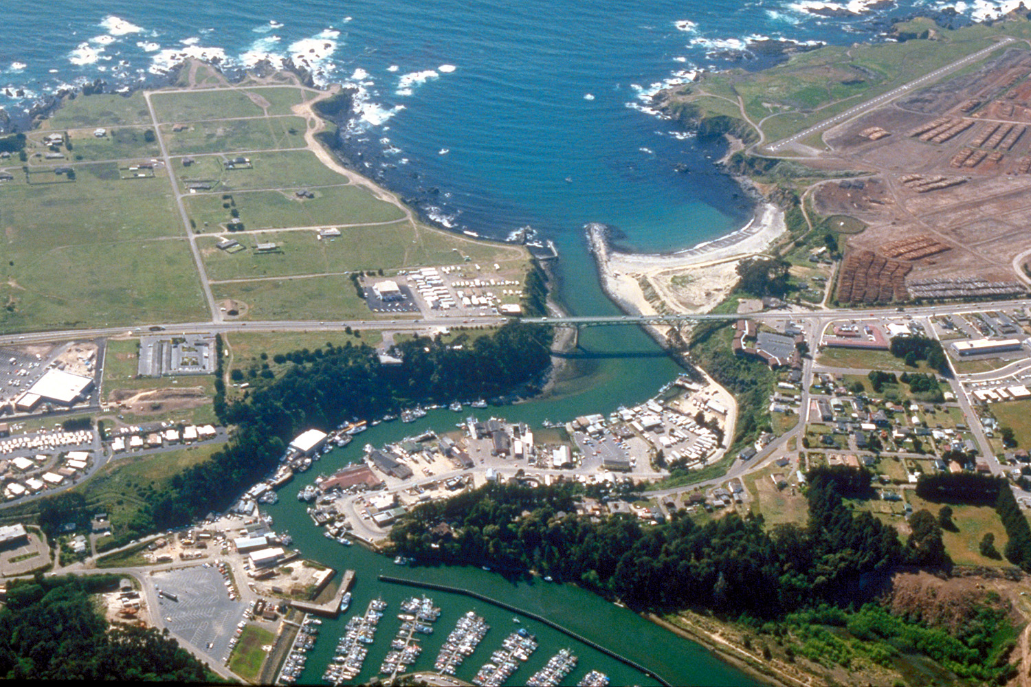
imagesize = 250px
image_caption = Aerial view of the southern section of Fort Bragg and the mouth of the Noyo River. State Route 1 crosses the river
subdivision_name2 = Mendocino
government_type =
leader_title =
leader_name =
established_date =
area_magnitude =
area_total_km2 = 7.2
area_land_km2 = 7.1
area_water_km2 = 0.1
area_total_sq_mi = 2.8
area_land_sq_mi = 2.7
area_water_sq_mi = 0.0
elevation_m = 26
elevation_ft = 85
latd = 39 |latm = 26 |lats = 32 |latNS = N
longd = 123 |longm = 48 |longs = 9 |longEW = W
population_as_of = 2000
population_total = 7,026
population_density_km2 = 993.7
timezone = PST
utc_offset = -8
timezone_DST = PDT
utc_offset_DST = -7
latitude = 39°26'32" N
longitude = 123°48'09" W
website = http://ci.fort-bragg.ca.us/
postal_code_type =ZIP code s
postal_code = 95437, 95488
area_code = 707
blank_name = FIPS code
blank_info = 06-25058
blank1_name = GNIS feature ID
blank1_info = 1656027
footnotes =Fort Bragg is a city located in coastal
Mendocino County, California along State Route 1, the major north-south highway along the Pacific Coast. Founded as a military fort during theAmerican Civil War , Fort Bragg is a popular tourist destination due to its picturesque views of thePacific Ocean and rugged Northern California coastline.Geography
Fort Bragg is located at coor dms|39|26|32|N|123|48|9|W|city (39.442155, -123.802463)GR|1 with an average elevation of convert|85|ft|m|abbr=on above sea level.
According to the
United States Census Bureau , the city has a total area of 2.8 square miles (7.2 km²), of which, 2.7 square miles (7.1 km²) of it is land and 0.04 square miles (0.1 km²) of it (1.44%) is water.Climate
Due to Fort Bragg's proximity to the
Pacific Ocean , the city has very mild weather throughout the year. Most of the rainfall occurs from November to April with some occasional drizzle or light showers during the summer. Fog and low overcast are common, especially during the night and early morning hours.January, the coldest month, has an average maximum temperature of convert|55.1|°F|°C|abbr=on and an average minimum temperature of convert|39.9|°F|°C|abbr=on; September, the warmest month, has an average maximum temperature of convert|65.8|°F|°C|abbr=on and an average minimum temperature of convert|49.2|°F|°C|abbr=on. Temperatures rarely reach 90 °F (32 °C), occurring on an average of only 0.1 day annually. Freezing temperatures occur on an average of 11.1 days annually. The record maximum temperature was convert|94|°F|°C|abbr=on on October 5, 1985 (exceeded by convert|96|°F|°C|abbr=on on October 23, 1965, at the airport, where records were kept from 1948 to 1972). The record minimum temperature was convert|18|°F|°C|abbr=on on December 21, 1990.
Average annual precipitation is convert|41.17|in|mm. The wettest year on record was 1995 with convert|61.90|in|mm and the driest year on record was 1976 with convert|21.01|in|mm. The maximum precipitation in one month was convert|21.60|in|mm in December 2002. The maximum 24 hour rainfall was convert|4.36|in|mm on December 28, 2002. [Western Regional Climate Center website (http://wrcc.dri.edu/)]
Demographics
As of the
census GR|2 of 2000, there were 7,026 people, 2,840 households, and 1,644 families residing in the city. Thepopulation density was 2,577.1 people per square mile (993.7/km²). There were 3,051 housing units at an average density of 1,119.1/sq mi (431.5/km²). The racial makeup of the city was 79.46% White, 1.04% Black or African American, 1.85% Native American, 0.88% Asian, 0.14% Pacific Islander, 12.06% from other races, and 4.57% from two or more races. 22.72% of the population were Hispanic or Latino of any race.There were 2,840 households out of which 30.1% had children under the age of 18 living with them, 40.4% were married couples living together, 13.0% had a female householder with no husband present, and 42.1% were non-families. 35.5% of all households were made up of individuals and 15.0% had someone living alone who was 65 years of age or older. The average household size was 2.35 and the average family size was 3.04.
In the city the population was spread out with 24.6% under the age of 18, 9.3% from 18 to 24, 30.0% from 25 to 44, 22.2% from 45 to 64, and 13.9% who were 65 years of age or older. The median age was 36 years. For every 100 females there were 100.6 males. For every 100 females age 18 and over, there were 99.3 males.
The median income for a household in the city was $28,539, and the median income for a family was $36,000. Males had a median income of $25,833 versus $23,287 for females. The
per capita income for the city was $15,832. About 11.9% of families and 20.4% of the population were below thepoverty line , including 26.5% of those under age 18 and 10.6% of those age 65 or over.Politics
In the state legislature Fort Bragg is located in the 2nd Senate District, represented by Democrat
Pat Wiggins , and in the 1st Assembly District, represented by Democrat Patty Berg. Federally, Fort Bragg is located inCalifornia's 1st congressional district , which has a Cook PVI of D +10 [cite web | title = Will Gerrymandered Districts Stem the Wave of Voter Unrest? | publisher = Campaign Legal Center Blog | url=http://www.clcblog.org/blog_item-85.html | accessdate = 2007-10-20] and is represented by DemocratMike Thompson .History
Founded during the Civil War, Fort Bragg was named for
Confederate States Army commanding officerBraxton Bragg by aUS Army soldier. Fort Bragg shares this namesake withFort Bragg, North Carolina . Much of the early industry in the town was centered around logging the vast redwood forests that lie near the coast.Recently, Georgia Pacific Lumber Company put on the market a convert|400|acre|km2|sing=on piece of property within the city limits, formerly the site of a large mill facility. The mill was shut down in 2002 and has been identified as a nonperforming asset by Georgia Pacific. The mill site takes up almost the entire coastline of Fort Bragg including Soldier Bay. The public of Fort Bragg has embraced the mill site as the future of Fort Bragg and has proposed many forward-thinking ideas. Some possibilities for the mill site are: a marine research center, a conference center, a world-class golf course, a smaller mill, or a branch of a college.
Points of Interest
Glass Beach sits on the northern edge of town, along the ocean. In the early 20th century, Fort Bragg residents threw their household trash over these cliffs. They discarded glass, appliances, and even cars. The land was owned at that time by the Union Lumber Company, and locals referred to it as "The Dumps." Sometimes fires would be lit to reduce the size of the trash pile. In 1967, city leaders closed the area and various cleanup programs were undertaken through the years to correct the damage. Over the next several decades the pounding waves cleansed the beach, wearing down the discarded glass into the small, smooth, colored trinkets that coat the beach today. The area is now frequently visited by tourists, who scour the beach for interesting curios to take home as souvenirs. Warning: the path from the road down to the beach is somewhat treacherous, so curious visitors should be sure to wear shoes with good tread. It is not uncommon for unprepared visitors to injure themselves on the way down.
Fort Bragg is the western terminus of the
California Western Railroad (otherwise known locally as the "Skunk Train"), running through theCoast Redwood forests to the city of Willits, convert|40|mi|km inland. Started in 1885 as a rail route for moving large logs to the mills, the Skunk Train now offers scenic tours through the redwoods.The city is also home to the
Mendocino Coast Botanical Gardens , a 47 acre garden along the coastal bluffs.Other points of interest:
*
Noyo Harbor
*MacKerricher State Park
*Russian Gulch State Park
*North Coast Brewing Company City Government
*Mayor- Doug Hammerstrom
*Vice Mayor- Dave Turner
*City Manager- Linda Ruffing
*Councilmembers
** Meg Courtney
** Dan Gjerde
** Jere MeloPeople from Fort Bragg
*
Jim Ross -Professional Wrestling commentator withWorld Wrestling Entertainment ; was born in Fort Bragg in 1952.
*Gregory E. Pyle - Current chief of theChoctaw Nation of Oklahoma . Now lives inDurant, Oklahoma .
*Cornelius Vander Starr - Founder of insurance giantAIG as well as the Starr Foundation, which gives money to various local causes.chools
Children in Fort Bragg attend
Fort Bragg High School , Fort Bragg Middle School, Dana Gray Elementary and Redwood Elementary.References
External links
* [http://www.fortbragg.com/ Fort Bragg website] , includes history, travel information, etc.
* [http://www.mendocinoconnection.com Mendocino Connection]
* [http://mendosearch.com/cityinfo-city_name-Fort%20Bragg.htm Fort Bragg, CA Travel Information]
* [http://www.cnn.com/2006/TRAVEL/DESTINATIONS/02/16/hidden.gems/index.html CNN article on Glass Beach] From trash to treasure: Unassuming coastal town home to glittering Glass Beach. By Susan C. Kim
Wikimedia Foundation. 2010.