- Mendocino County, California
Infobox U.S. County
county = Mendocino County
state = California
map size = 250
founded = 1850
seat = Ukiah | largest city = Ukiah | area_total_sq_mi =3878
area_land_sq_mi =3509
area_water_sq_mi =369
area percentage = 9.52%
census yr = 2000
pop = 86265
density_km2 =9
web = www.co.mendocino.ca.us
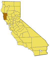
|Mendocino County is a
county located on the north coast of theU.S. state ofCalifornia , north of the greaterSan Francisco Bay Area and west of the Central Valley. As of 2000, the population was 86,265. Thecounty seat is Ukiah.The county is noted for its distinctive
Pacific Ocean coastline, Redwood forests, wine production and liberal views on marijuana.The notable historic and recreational attraction of the "Skunk Train" connects Fort Bragg with
Willits in Mendocino County via steam-locomotive trains and other vehicles.History
Mendocino County was one of the original counties of California, created in 1850 at the time of statehood. Due to an initially low population, it did not have a separate government until 1859 and was under the administration of
Sonoma County prior to that. The county contains several of the original Spanish land grants ofAlta California including the Sanel Rancho in Hopland, and the Yokayo Rancho that forms the majority of the Ukiah Valley.The county derives its name from
Cape Mendocino , which was probably named in honor of eitherAntonio de Mendoza ,Viceroy ofNew Spain , 1535–1542 (who sent theJuan Cabrillo Expedition to this coast in 1542), or Lorenzo Suárez de Mendoza, Viceroy from 1580 to 1583. "Mendocino" is the adjectival form of thefamily name of Mendoza.In the 19th century, the county witnessed many of the most serious atrocities in the extermination of the Californian Native American tribes who originally lived in the area, like the Yuki, the
Pomo and theWintun . The systematic occupation of their lands, the reduction of many of their members into slavery and the raids against their settlements led to theMendocino War in 1859, where hundreds of Indians were killed. The segregation continued well into the 20th century; and today the local Native Americans are fighting for land rights, to obtain gaming operations and against widespread poverty.Geography
According to the U.S. Census Bureau, the county has a total area of 3,878 square miles (10,044 km²), of which, 3,509 square miles (9,088 km²) of it is land and 369 square miles (956 km²) of it (9.52%) is water.
Cities and towns
*Albion
*Anchor Bay
*Boonville
*Branscomb
*Calpella
*Caspar
*Cleone
*Comptche
*Covelo
*Dos Rios
*Elk
*Fort Bragg
*Gualala
*Hopland
*Inglenook
*Laytonville
*Leggett
*Little River
*Longvale
*Manchester
*Mendocino
*Navarro
*Noyo
*Old Hopland
*Philo
*Point Arena
*Potter Valley
*Redwood Valley
*Rockport
*Talmage
*Ukiah
*Willits
*Westport
*YorkvilleAdjacent counties
*
Sonoma County, California - south
*Lake County, California - east
*Glenn County, California - east
*Tehama County, California - northeast
*Trinity County, California - north
*Humboldt County, California - northTransportation infrastructure
Major highways
*
*
*
*
*Public transportation
The
Mendocino Transit Authority provides local and intercity bus service within Mendocino County. Limited service also connects with transit in Sonoma CountyThe
Greyhound Bus Lines currently servesUkiah .AMTRAK has bus service that connects Mendocino to passenger service on rail lines such as the "Coast Starlight".The historic "Skunk Train" connects
Fort Bragg withWillits in Mendocino County via steam-locomotive trains and other vehicles. Conceivably, it could be used for public transportation, as well as its recreational uses.Airports
*
Ukiah Regional Airport is a general aviation airport owned by the City of Ukiah. It is located south of downtown Ukiah.
*Little River Airport is a general aviation airport serving the Mendocino coast.For commercial service, passengers in Mendocino County need to go to Eureka, one county to the north inHumboldt County , or toSacramento orSan Francisco , well to the south.Demographics
As of the
census GR|2 of 2000, there were 86,265 people, 33,266 households, and 21,855 families residing in the county. Thepopulation density was 25 people per square mile (9/km²). There were 36,937 housing units at an average density of 10 per square mile (4/km²). The racial makeup of the county was 80.76% White, 0.62% Black or African American, 4.76% Native American, 1.20% Asian, 0.15% Pacific Islander, 8.61% from other races, and 3.90% from two or more races. 16.48% of the population were Hispanic or Latino of any race. 12.2% were of German, 10.8% English, 8.6% Irish, 6.1% Italian and 5.6% American ancestry according toCensus 2000 . 84.4% spoke English and 13.2% Spanish as their first language.There were 33,266 households out of which 31.4% had children under the age of 18 living with them, 48.9% were married couples living together, 11.7% had a female householder with no husband present, and 34.3% were non-families. 27.0% of all households were made up of individuals and 10.4% had someone living alone who was 65 years of age or older. The average household size was 2.53 and the average family size was 3.04.
In the county the population was spread out with 25.5% under the age of 18, 8.1% from 18 to 24, 25.6% from 25 to 44, 27.1% from 45 to 64, and 13.6% who were 65 years of age or older. The median age was 39 years. For every 100 females there were 98.9 males. For every 100 females age 18 and over, there were 97.1 males.
The median income for a household in the county was $35,996, and the median income for a family was $42,168. Males had a median income of $33,128 versus $23,774 for females. The
per capita income for the county was $19,443. About 10.9% of families and 15.9% of the population were below thepoverty line , including 21.5% of those under age 18 and 7.7% of those age 65 or over.Government
*Chief Executive Officer- Tom Mitchell
*Board of Supervisors
**1st District-Michael Delbar
**2nd District-Jim R. Wattenburger
**3rd District-John Pinches
**4th District-Kendall Smith
**5th District-J. David ColfaxPolitics
Mendocino is a strongly Democratic county in Presidential and congressional elections. [ [http://www.epodunk.com/cgi-bin/politicalInfo.php?locIndex=10497] , epodunk.com] The last Republican to win a majority in the county was
Ronald Reagan in 1980 and 1984. It is part ofCalifornia's 1st congressional district , which is held by DemocratMike Thompson . In the state legislature Mendocino is in the 1st Assembly district, which is held by Democrat Patty Berg, and the 2nd Senate district, which is held by DemocratPat Wiggins . As of April 2008, theCalifornia Secretary of State reports that Mendocino County has 47,168 registered voters. Of those, 22,264 (47.2%) are registered Democratic; 11,422 (24.2%) are registered Republican; 4,179 (8.9%) are registered with other political parties, and 9,303 (19.7%) declined to state a political party.In 2000, Mendocino County voters approved Measure G, which calls for the decriminalization of marijuana when used and cultivated for personal use. [ [http://www.canorml.org/news/mendorelse.html] , canorml.org] Measure G passed with a 58% majority vote, making it the first county in the United States to declare prosecution of small-scale marijuana offenses the "lowest priority" for local law enforcement. Measure G does not protect individuals who cultivate, transport or possess marijuana for sale. However, Measure G was passed at the local government level affecting only Mendocino County, and therefore does not affect existing state or federal laws. The city of Berkeley has had a similar law since 1979 which has generally been found to be unenforceable. [ [http://www.berkeleydailyplanet.com/article.cfm?archiveDate=03-31-06&storyID=23788] , berkeleydailyplanet.com]
In 2008, the Mendocino County Board of Supervisors placed Measure B on the June 3 county-wide ballot. After three months of hard-fought campaigning and national attention, voters narrowly approved "B", which repealed most of the provisions of 2000's Measure G. [ [http://ballotpedia.org/wiki/index.php?title=Mendocino_County_Measure_B_%28June_2008%29 "Measure B on the June 3 ballot"] , Ballotpedia.] [ [http://www.ukiahdailyjournal.com/ci_9659274?source=most_viewed It's official: Marijuana reform effort passes - Ukiah Daily Journal ] ] However, opponents of Measure B intend to continue the challenge in court as the wording of Measure B relies heavily on S.B. 420's state limitations which were recently ruled unconstitutional by the California supreme court. On July 3rd, the Sheriff and District Attorneys offices announced that they would not be enforcing the new regulations for the time being, citing pending legal challenges and conflicts with existing state law. [ [http://www.pressdemocrat.com/article/20080703/NEWS/807030377/1350 Mendocino County won't enforce pot measure | PressDemocrat.com | The Press Democrat | Santa Rosa, CA ] ]
In 2004, Measure H was passed in Mendocino County with a 57% majority, making it the first county in the United States to ban the production and cultivation of
genetically modified organism s.Rivers
"from south to north"
*Russian River (inland)
*Gualala River
*Garcia River
*Elk Creek
*Navarro River
*Albion River
* Little River
*Big River
*Noyo River
*Pudding Creek
*Ten Mile River
*Eel River (inland)Beaches
*Big River Beach
*Caspar Headlands State Beach
*Van Damme Beach
*Greenwood State Beach
*Seaside Beach
*Wesport-Union Landing State Beach
*Manchester State Beach
*Navarro Beach
*Portuguese Beach
*Schooner Gulch State Beach
*Long Valley Creek
* 10 Mile CreekParks, reserves and related places
*
Admiral William Standley State Recreation Area
*Caspar Headlands State Recreation Area
*Hendy Woods State Park
*Jughandle State Reserve
*MacKerricher State Park
*Mailliard Redwoods State Reserve
*Manchester State Park
*Mendocino Coast Botanical Gardens
*Mendocino Headlands State Park
*Mendocino National Forest
*Mendocino Woodlands State Park
*Montgomery Woods State Reserve
*Navarro River Redwoods State Park
*Point Cabrillo Light Station
*Reynolds Wayside Campground
*Round Valley Indian Reservation
*Russian Gulch State Park
*Sinkyone Wilderness State Park
*Smythe Redwoods State Reserve
*Standish-Hickey State Recreation Area
*Van Damme State Park Education
Community Colleges
*College of the Redwoods (satellite campus) in Fort Bragg
*Mendocino College in UkiahLocal Schools
*Mendocino K-12 Public School DistrictsReferences
External links
* [http://www.gomendo.com Mendocino County Official Travel Website]
* [http://www.co.mendocino.ca.us/ County of Mendocino official website]
* [http://mendosearch.com Mendocino County Travel Information]
* [http://www.mendocinoconnection.com/ Mendocino Connection]
* [http://www.co.mendocino.ca.us/museum Mendocino County Museum]
* [http://www.openroad.tv/index.php?categoryid=16&p25_id=28 Mendocino's Movie History - Information and Video]
Wikimedia Foundation. 2010.