- Mendocino, California
-
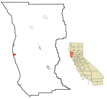
Mendocino — census-designated place — Mendocino, California Location in Mendocino County and the state of California Coordinates: 39°18′28″N 123°47′58″W / 39.30778°N 123.79944°WCoordinates: 39°18′28″N 123°47′58″W / 39.30778°N 123.79944°W Country  United States
State  California
County Mendocino Area[1] – Total 7.420 sq mi (19.220 km2) – Land 2.257 sq mi (5.847 km2) – Water 5.163 sq mi (13.373 km2) 69.58% Elevation[2] 154 ft (47 m) Population (2010) – Total 894 – Density 120.5/sq mi (46.5/km2) Time zone Pacific (PST) (UTC-8) – Summer (DST) PDT (UTC-7) ZIP code 95460 Area code(s) 707 FIPS code 06-46814 GNIS feature ID 1659106 Mendocino (formerly, Big River,[2] Meiggstown,[2] and Mendocino City[3]) is a census-designated place (CDP) in Mendocino County, California, United States. Mendocino is located 9.5 miles (15 km) south of Fort Bragg,[3] at an elevation of 154 feet (47 m).[2] The population was 894 at the 2010 census, up from 824 at the 2000 census.
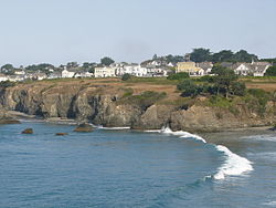
Despite its small size, the town's scenic location on a headland surrounded by the Pacific Ocean has made it extremely popular as an artist colony and with vacationers. Because it is less than four hours by car from the San Francisco Bay Area, it is a popular weekend getaway spot for Bay Area residents.
Contents
History
Prior to 1850, a Pomo settlement named Buldam was located near Mendocino on the north bank of the Big River. The town was founded in 1850 as a logging community, and was originally named Meiggsville after Henry Meiggs. The first post office opened in 1858.[3] Many of its early settlers were New Englanders, as was true with many older Northern California logging towns. Its economy declined after 1940, and it became a somewhat isolated village with a declining population. The revitalization of the town began in the late 1950s with the founding of the Mendocino Art Center by artist Bill Zacha.[4][5][6]
Since 1987, Mendocino has been the site of the Mendocino Music Festival, a classically-based but musically diverse series of concerts that is held annually in a huge circus type performance tent on the town's Main Street in the Mendocino Headlands State Park.
Most of the town was added to the National Register of Historic Places listings in Mendocino County, California in 1971 as the Mendocino and Headlands Historic District.[7] Mendocino Presbyterian Church on Main Street, dedicated on July 5, 1868, is one of the oldest continuously-used Protestant churches in California, and is designated as California Historical Landmark #714. In addition, the Temple of Kwan Tai on Albion Street, California Historical Landmark #927, may be as old as 1854 and is one of the oldest Chinese houses of worship in California.[8]
The town's name comes from Cape Mendocino, named by early Spanish navigators in honor of Antonio de Mendoza, Viceroy of New Spain.
Geography
Mendocino is located at 39°18′28″N 123°47′58″W / 39.30778°N 123.79944°W.[2]
According to the United States Census Bureau, the CDP has a total area of 7.4 square miles (19 km2), of which, 2.3 square miles (6.0 km2) of it is land and 5.2 square miles (13 km2) of it (69.58%) is water.
Mendocino experiences a cool summer Maritime Mediterranean climate. Summers are characterized by frequent fog and highs mostly in the upper sixties and lows in the fifties. Winters rarely, if ever, see frost or snow, due to close proximity to the Pacific Ocean. Mendocino averages about 43 inches of rain per year concentrated mainly in fall, winter, spring, and early summer.
Demographics
2010
The 2010 United States Census[9] reported that Mendocino had a population of 894. The population density was 120.5 people per square mile (46.5/km²). The racial makeup of Mendocino was 834 (93.3%) White, 5 (0.6%) African American, 8 (0.9%) Native American, 13 (1.5%) Asian, 1 (0.1%) Pacific Islander, 6 (0.7%) from other races, and 27 (3.0%) from two or more races. Hispanic or Latino of any race were 42 persons (4.7%).
The Census reported that 830 people (92.8% of the population) lived in households, 64 (7.2%) lived in non-institutionalized group quarters, and 0 (0%) were institutionalized.
There were 447 households, out of which 62 (13.9%) had children under the age of 18 living in them, 177 (39.6%) were opposite-sex married couples living together, 22 (4.9%) had a female householder with no husband present, 15 (3.4%) had a male householder with no wife present. There were 29 (6.5%) unmarried opposite-sex partnerships, and 6 (1.3%) same-sex married couples or partnerships. 178 households (39.8%) were made up of individuals and 83 (18.6%) had someone living alone who was 65 years of age or older. The average household size was 1.86. There were 214 families (47.9% of all households); the average family size was 2.41.
The population was spread out with 93 people (10.4%) under the age of 18, 58 people (6.5%) aged 18 to 24, 166 people (18.6%) aged 25 to 44, 333 people (37.2%) aged 45 to 64, and 244 people (27.3%) who were 65 years of age or older. The median age was 56.1 years. For every 100 females there were 89.8 males. For every 100 females age 18 and over, there were 83.7 males.
There were 617 housing units at an average density of 83.1 per square mile (32.1/km²), of which 271 (60.6%) were owner-occupied, and 176 (39.4%) were occupied by renters. The homeowner vacancy rate was 3.9%; the rental vacancy rate was 9.2%. 520 people (58.2% of the population) lived in owner-occupied housing units and 310 people (34.7%) lived in rental housing units.
2000
As of the census[10] of 2000, there were 824 people, 424 households, and 220 families residing in the CDP. The population density was 363.8 people per square mile (140.2/km²). There were 549 housing units at an average density of 242.4 per square mile (93.4/km²). The racial makeup of the CDP was 95.51% White, 0.36% Native American, 1.09% Asian, 0.73% from other races, and 2.31% from two or more races. Hispanic or Latino of any race were 2.79% of the population.
There were 424 households out of which 18.4% had children under the age of 18 living with them, 43.2% were married couples living together, 6.8% had a female householder with no husband present, and 47.9% were non-families. 38.0% of all households were made up of individuals and 15.6% had someone living alone who was 65 years of age or older. The average household size was 1.94 and the average family size was 2.51.
In the CDP the population was spread out with 15.5% under the age of 18, 3.5% from 18 to 24, 20.6% from 25 to 44, 38.0% from 45 to 64, and 22.3% who were 65 years of age or older. The median age was 51 years. For every 100 females there were 78.0 males. For every 100 females age 18 and over, there were 75.3 males.
The median income for a household in the CDP was $44,107, and the median income for a family was $59,167. Males had a median income of $41,667 versus $29,875 for females. The per capita income for the CDP was $29,348. About 6.3% of families and 13.3% of the population were below the poverty line, including 7.3% of those under age 18 and 17.8% of those age 65 or over.
Economy
Mendocino is home to a large number of bed and breakfasts. It has a small downtown with a number of art shops and small restaurants.
Politics
In the state legislature Mendocino is located in the 2nd Senate District, represented by Democrat Noreen Evans, and in the 1st Assembly District, represented by Democrat Wesley Chesbro. Federally, Mendocino is located in California's 1st congressional district, which has a Cook PVI of D +10[11] and is represented by Democrat Mike Thompson.
Movie and TV filming
Many movies have been filmed in and around Mendocino and Mendocino County, including Dying Young, The Russians Are Coming; Overboard (actually filmed in Fort Bragg); The Dunwich Horror; The Karate Kid, Part III; Dead & Buried; Forever Young; Same Time Next Year; Racing with the Moon (partially filmed in Fort Bragg); Pontiac Moon; and The Majestic (also partially filmed in Fort Bragg). Mendocino was depicted as turn of the last century Monterey in the James Dean classic East of Eden. "Summer of '42" starring Jennifer O'Neil included local Mendocino High School students.
However, the TV series Murder, She Wrote has had the largest impact on the community. Murder, She Wrote was set in the fictional town of Cabot Cove, Maine. Nine episodes of the 264-episode program were filmed in Mendocino, while exterior shots throughout Mendocino were used in the remaining episodes. The program was broadcast for 12 seasons, from September 1984 until May 1996, and won many awards. Many local residents looked forward to the yearly filming, as over a hundred and fifty were chosen to play background parts. A lucky few were cast for speaking roles. Poet, playwright and actor Lawrence Bullock cites being cast in a speaking role as a "Townsperson" in the episode "Indian Giver" as giving him eligibility to join the Screen Actors' Guild. Locals Linda Pack, James Henderson and others were also cast in speaking roles. The main character Jessica Fletcher's home in the series was an actual home in Mendocino and is now a bed and breakfast under the name "Blair House."
While scenes for Murder, She Wrote were being filmed in Mendocino, residents say that it was not uncommon to see Angela Lansbury, who played Jessica Fletcher, stop to speak with a toddler, or for Tom Bosley to sign his autograph on a Glad Bag box presented by a shopper stepping out of the local grocery store. Murder, She Wrote also brought in more money to the town due to increased tourism — by some estimates, around $2,000,000. The local high school band appeared in one of the episodes and received enough money from the appearance to go on a band trip.
Mendocino is also the home of the Mendocino Film Festival which was first held in May 2006. Because the area is a haven for artists, the festival honors them with a special "artist category", in addition to the documentary, feature and short film categories.
Sister city
Mendocino is a sister city with Miasa, Japan, a relationship that formed due to the friendship of Mendocino artist Bill Zacha and Japanese artist Tōshi Yoshida and that was formalized in 1980.[6] Every other year Miasa students visit Mendocino middle school students.[12][13]
Local state parks
References
- ^ U.S. Census
- ^ a b c d e U.S. Geological Survey Geographic Names Information System: Mendocino, California
- ^ a b c Durham, David L. (1998). California's Geographic Names: A Gazetteer of Historic and Modern Names of the State. Quill Driver Books. p. 105. ISBN 9781884995149.
- ^ "A young man saves an old town", Look, September 25, 1962, http://www.williamzacha.com/zacha_legacy.php.
- ^ "Mendocino—Newest Art Colony in U.S.", Los Angeles Times, January 12, 1964.
- ^ a b Swartz, Susan (December 17, 1995), "The artist who put Mendocino on the map", Santa Rosa Press-Democrat.
- ^ "National Register Information System". National Register of Historic Places. National Park Service. 2009-09-03. http://nrhp.focus.nps.gov/natreg/docs/All_Data.html.
- ^ California Historical Landmarks: Mendocino County. Mendocino Presbyterian Church and Temple of Kuan Ti, Thomas Brightbill.
- ^ All data are derived from the United States Census Bureau reports from the 2010 United States Census, and are accessible on-line here. The data on unmarried partnerships and same-sex married couples are from the Census report DEC_10_SF1_PCT15. All other housing and population data are from Census report DEC_10_DP_DPDP1. Both reports are viewable online or downloadable in a zip file containing a comma-delimited data file. The area data, from which densities are calculated, are available on-line here. Percentage totals may not add to 100% due to rounding. The Census Bureau defines families as a household containing one or more people related to the householder by birth, opposite-sex marriage, or adoption. People living in group quarters are tabulated by the Census Bureau as neither owners nor renters. For further details, see the text files accompanying the data files containing the Census reports mentioned above.
- ^ "American FactFinder". United States Census Bureau. http://factfinder.census.gov. Retrieved 2008-01-31.
- ^ "Will Gerrymandered Districts Stem the Wave of Voter Unrest?". Campaign Legal Center Blog. http://www.clcblog.org/blog_item-85.html. Retrieved 2007-10-20.
- ^ "Japanese students arrive for week-long visit", Santa Rosa Press-Democrat, August 3, 1996.
- ^ Korbel, Connie (May 25, 2006), "Mendocino hosts Miasa sister city group", Mendocino Beacon.
External links
Municipalities and communities of Mendocino County, California Cities Fort Bragg | Point Arena | Ukiah | Willits
CDPs Albion | Anchor Bay | Boonville | Brooktrails | Calpella | Caspar | Cleone | Comptche | Covelo | Hopland | Laytonville | Leggett | Little River | Manchester | Mendocino | Philo | Potter Valley | Redwood Valley | Talmage
Unincorporated
communitiesAlpine | Andersonia | Arnold | Asylum | Bell Springs | Bowman Place | Branscomb | Bredehoft Place | Burbeck | Cameron | Cape Horn | Card Place | Carpenter Place | Clare Mill | Cooks Valley | Crowley | Cubbler Place | Cummings | Dawes | DeCamp | DeHaven | Delmonico Place | Dos Rios | Duncan Springs | Dunlap Place | El Roble | Elk | Fair Oaks | Farley | Fish Rock | Flumeville | Four Pines | Gallaway | Glenblair | Grove | Gualala | Hales Grove | Hardy | Hardy Place | Hays Place | Hearst | Heath Place | Heeser Addition | Hendy Grove | Indian Springs | Inglenook | Ingram | Irmulco | Jim Leggett Place | Kibesillah | Largo | Laughlin | Little Penny | Longvale | Marble Place | Marks Place | McClure Place | Melbourne | Mina | Montgomery | Nacomis Indian Rancheria | Nashmead | Navarro | Newport | Northspur | Noyo | Oasis | Old Bailey Place | Old Hopland | Old Ornbaun Hot Springs | Old Red Rock Place | O'Neil Place | Orrs Springs | Philbrick Mill | Piercy | Pieta | Pine Grove | Pomo | Pratt Place | Presswood | Ralph Leggett Place | Ramsey | Redwood Lodge | Reeves Place | Regina Heights | Reilly Heights | Reyes Place | Ridge | Ridgewood Park | Riverdale | Shake City | Simerson | Soda Springs (Boonville) | Soda Springs (Burbeck) | South Fork | South Leggett | Spyrock | Stronetta | Tan Oak Park | Tatu | The Forks | The Oaks | Twin Rocks | Ukiah Rancheria | Underwood Park | Union Landing | Upp | Vichy Springs | Wanhala | Westport | Whiskey Springs | Whitesboro | Woodman | Yorkville
Indian
reservationsCoyote Valley Reservation | Guidiville Rancheria | Hopland Rancheria | Iverson Indian Rancheria | Manchester-Point Arena Rancheria | Pinoleville Rancheria | Potter Valley Rancheria | Sherwood Valley Rancheria | Redwood Valley Rancheria | Round Valley Indian Reservation
Former
settlementsAnderson | Arthur | Bentley | Bokea | Bucknell | Buldam | Cahto | Carbon | Carey | Chomchadila | Christine | Christine Junction | Clearbrook | Comfort | Crittendon | Dapishul | Dellavan | Duffey | Dunlap | Echo | Empire | En Cimo | Fairbanks | Fountain | Gracy | Half Way | Hardin | Hermitage | Iverson | Junction | Kenny | Lane Redwood Flat | Lema | Masut | Melborne Camp | Moiya | Muir Springs | North Fork House | Northwestern | Noyo Lodge | Ornbaun | Poonkiny | Rankin | Redwine | Reynolds | River Garden | Rockport | Rodgers | Rowes | Salmon Creek | Salsig | Sawyers | Sherburns | Shiegho | Signal Port | Sunnyside | Sylvandale | Tilly | Tolson | Tomki | Tomkiah | Ubakhea | Ulco | Usal | Wendling | Wheeler | Whitehall
Categories:- Populated coastal places in California
- Census-designated places in Mendocino County, California
- Populated places established in 1850
Wikimedia Foundation. 2010.


