- Covelo, California
-
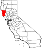
Covelo — census-designated place — Location in Mendocino County and the state of California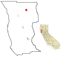
Coordinates: 39°47′35″N 123°14′53″W / 39.79306°N 123.24806°WCoordinates: 39°47′35″N 123°14′53″W / 39.79306°N 123.24806°W Country  United States
State  California
County Mendocino Area[1] – Total 7.138 sq mi (18.489 km2) – Land 7.095 sq mi (18.377 km2) – Water 0.043 sq mi (0.112 km2) 0.60% Elevation[2] 1,398 ft (426 m) Population (2010) – Total 1,255 – Density 175.8/sq mi (67.9/km2) Time zone Pacific (PST) (UTC-8) – Summer (DST) PDT (UTC-7) ZIP code 95428 Area code(s) 707 FIPS code 06-16728 GNIS feature ID 0277603 Covelo is a census-designated place (CDP) in Mendocino County, California, United States. Covelo is located 14 miles (23 km) east-northeast of Laytonville,[3] at an elevation of 1398 feet (426 m).[2] The population was 1,255 at the 2010 census, up from 1,175 at the 2000 census.
Contents
Geography
Covelo is located at 39°47′35″N 123°14′53″W / 39.79306°N 123.24806°W.[2]
According to the United States Census Bureau, the CDP has a total area of 7.1 square miles (18 km2), 99.40% of it land, 0.60% of it water.
Covelo is the location of the Covelo American Viticultural Area.
History
Covelo began in 1860, with the opening of the town's first store.[3] The post office opened in 1870.[3] The town was named after a village in Switzerland.[3]
Demographics
2010
The 2010 United States Census[4] reported that Covelo had a population of 1,255. The population density was 175.8 people per square mile (67.9/km²). The racial makeup of Covelo was 611 (48.7%) White, 14 (1.1%) African American, 475 (37.8%) Native American, 10 (0.8%) Asian, 0 (0.0%) Pacific Islander, 49 (3.9%) from other races, and 96 (7.6%) from two or more races. Hispanic or Latino of any race were 163 persons (13.0%).
The Census reported that 1,247 people (99.4% of the population) lived in households, 0 (0%) lived in non-institutionalized group quarters, and 8 (0.6%) were institutionalized.
There were 481 households, out of which 148 (30.8%) had children under the age of 18 living in them, 146 (30.4%) were opposite-sex married couples living together, 81 (16.8%) had a female householder with no husband present, 56 (11.6%) had a male householder with no wife present. There were 70 (14.6%) unmarried opposite-sex partnerships, and 0 (0%) same-sex married couples or partnerships. 148 households (30.8%) were made up of individuals and 53 (11.0%) had someone living alone who was 65 years of age or older. The average household size was 2.59. There were 283 families (58.8% of all households); the average family size was 3.25.
The population was spread out with 339 people (27.0%) under the age of 18, 105 people (8.4%) aged 18 to 24, 320 people (25.5%) aged 25 to 44, 299 people (23.8%) aged 45 to 64, and 192 people (15.3%) who were 65 years of age or older. The median age was 35.8 years. For every 100 females there were 97.3 males. For every 100 females age 18 and over, there were 99.6 males.
There were 542 housing units at an average density of 75.9 per square mile (29.3/km²), of which 314 (65.3%) were owner-occupied, and 167 (34.7%) were occupied by renters. The homeowner vacancy rate was 2.2%; the rental vacancy rate was 3.4%. 791 people (63.0% of the population) lived in owner-occupied housing units and 456 people (36.3%) lived in rental housing units.
2000
As of the census[5] of 2000, there were 1,175 people, 442 households, and 301 families residing in the CDP. The population density was 164.9 people per square mile (63.6/km²). There were 512 housing units at an average density of 71.8 per square mile (27.7/km²). The racial makeup of the CDP was 50.21% White, 0.85% Black or African American, 40.26% Native American, 0.34% Asian, 0.17% Pacific Islander, 1.96% from other races, and 6.21% from two or more races. 8.09% of the population were Hispanic or Latino of any race.
There were 442 households out of which 29.4% had children under the age of 18 living with them, 43.2% were married couples living together, 20.1% had a female householder with no husband present, and 31.7% were non-families. 26.0% of all households were made up of individuals and 7.5% had someone living alone who was 65 years of age or older. The average household size was 2.66 and the average family size was 3.17.
In the CDP the population was spread out with 28.9% under the age of 18, 8.9% from 18 to 24, 23.1% from 25 to 44, 27.1% from 45 to 64, and 12.2% who were 65 years of age or older. The median age was 36 years. For every 100 females there were 92.9 males. For every 100 females age 18 and over, there were 90.4 males.
The median income for a household in the CDP was $27,639, and the median income for a family was $31,875. Males had a median income of $21,146 versus $17,014 for females. The per capita income for the CDP was $12,628. About 17.1% of families and 27.1% of the population were below the poverty line, including 36.4% of those under age 18 and 10.8% of those age 65 or over.
Politics
In the state legislature Covelo is located in the 2nd Senate District, represented by Democrat Noreen Evans, and in the 1st Assembly District, represented by Democrat Wesley Chesbro. Federally, Covelo is located in California's 1st congressional district, which has a Cook PVI of D +10[6] and is represented by Democrat Mike Thompson.
References
- ^ U.S. Census
- ^ a b c U.S. Geological Survey Geographic Names Information System: Covelo, California
- ^ a b c d Durham, David L. (1998). California's Geographic Names: A Gazetteer of Historic and Modern Names of the State. Quill Driver Books. p. 43. ISBN 9781884995149.
- ^ All data are derived from the United States Census Bureau reports from the 2010 United States Census, and are accessible on-line here. The data on unmarried partnerships and same-sex married couples are from the Census report DEC_10_SF1_PCT15. All other housing and population data are from Census report DEC_10_DP_DPDP1. Both reports are viewable online or downloadable in a zip file containing a comma-delimited data file. The area data, from which densities are calculated, are available on-line here. Percentage totals may not add to 100% due to rounding. The Census Bureau defines families as a household containing one or more people related to the householder by birth, opposite-sex marriage, or adoption. People living in group quarters are tabulated by the Census Bureau as neither owners nor renters. For further details, see the text files accompanying the data files containing the Census reports mentioned above.
- ^ "American FactFinder". United States Census Bureau. http://factfinder.census.gov. Retrieved 2008-01-31.
- ^ "Will Gerrymandered Districts Stem the Wave of Voter Unrest?". Campaign Legal Center Blog. http://www.clcblog.org/blog_item-85.html. Retrieved 2007-10-20.
Municipalities and communities of Mendocino County, California Cities Fort Bragg | Point Arena | Ukiah | Willits
CDPs Albion | Anchor Bay | Boonville | Brooktrails | Calpella | Caspar | Cleone | Comptche | Covelo | Hopland | Laytonville | Leggett | Little River | Manchester | Mendocino | Philo | Potter Valley | Redwood Valley | Talmage
Unincorporated
communitiesAlpine | Andersonia | Arnold | Asylum | Bell Springs | Bowman Place | Branscomb | Bredehoft Place | Burbeck | Cameron | Cape Horn | Card Place | Carpenter Place | Clare Mill | Cooks Valley | Crowley | Cubbler Place | Cummings | Dawes | DeCamp | DeHaven | Delmonico Place | Dos Rios | Duncan Springs | Dunlap Place | El Roble | Elk | Fair Oaks | Farley | Fish Rock | Flumeville | Four Pines | Gallaway | Glenblair | Grove | Gualala | Hales Grove | Hardy | Hardy Place | Hays Place | Hearst | Heath Place | Heeser Addition | Hendy Grove | Indian Springs | Inglenook | Ingram | Irmulco | Jim Leggett Place | Kibesillah | Largo | Laughlin | Little Penny | Longvale | Marble Place | Marks Place | McClure Place | Melbourne | Mina | Montgomery | Nacomis Indian Rancheria | Nashmead | Navarro | Newport | Northspur | Noyo | Oasis | Old Bailey Place | Old Hopland | Old Ornbaun Hot Springs | Old Red Rock Place | O'Neil Place | Orrs Springs | Philbrick Mill | Piercy | Pieta | Pine Grove | Pomo | Pratt Place | Presswood | Ralph Leggett Place | Ramsey | Redwood Lodge | Reeves Place | Regina Heights | Reilly Heights | Reyes Place | Ridge | Ridgewood Park | Riverdale | Shake City | Simerson | Soda Springs (Boonville) | Soda Springs (Burbeck) | South Fork | South Leggett | Spyrock | Stronetta | Tan Oak Park | Tatu | The Forks | The Oaks | Twin Rocks | Ukiah Rancheria | Underwood Park | Union Landing | Upp | Vichy Springs | Wanhala | Westport | Whiskey Springs | Whitesboro | Woodman | Yorkville
Indian
reservationsCoyote Valley Reservation | Guidiville Rancheria | Hopland Rancheria | Iverson Indian Rancheria | Manchester-Point Arena Rancheria | Pinoleville Rancheria | Potter Valley Rancheria | Sherwood Valley Rancheria | Redwood Valley Rancheria | Round Valley Indian Reservation
Former
settlementsAnderson | Arthur | Bentley | Bokea | Bucknell | Buldam | Cahto | Carbon | Carey | Chomchadila | Christine | Christine Junction | Clearbrook | Comfort | Crittendon | Dapishul | Dellavan | Duffey | Dunlap | Echo | Empire | En Cimo | Fairbanks | Fountain | Gracy | Half Way | Hardin | Hermitage | Iverson | Junction | Kenny | Lane Redwood Flat | Lema | Masut | Melborne Camp | Moiya | Muir Springs | North Fork House | Northwestern | Noyo Lodge | Ornbaun | Poonkiny | Rankin | Redwine | Reynolds | River Garden | Rockport | Rodgers | Rowes | Salmon Creek | Salsig | Sawyers | Sherburns | Shiegho | Signal Port | Sunnyside | Sylvandale | Tilly | Tolson | Tomki | Tomkiah | Ubakhea | Ulco | Usal | Wendling | Wheeler | Whitehall
Categories:- Census-designated places in Mendocino County, California
- Populated places established in 1860


Wikimedia Foundation. 2010.