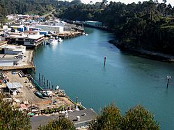
- Noyo, California
-
For the river itself, see Noyo River.
Noyo — Unincorporated community — Noyo Harbor in 2009 Location in California Coordinates: 39°25′42″N 123°48′12″W / 39.42833°N 123.80333°WCoordinates: 39°25′42″N 123°48′12″W / 39.42833°N 123.80333°W Country United States State California County Mendocino County Elevation[1] 108 ft (33 m) Noyo (formerly, "Noyo River")[2] is an unincorporated community in Mendocino County, California.[1] It is located 1 mile (1.6 km) south of the center of Fort Bragg,[2] at an elevation of 108 feet (33 m).[1] It is named after the Noyo River, on which it lies; the Noyo River in turn was misnamed by white settlers to the Mendocino area after a village of the Pomo people named Noyo several miles north, on Pudding Creek. The Pomo named the creek after their village, and the settlers transferred the name to the larger river to the south.[3]
The Noyo River post office operated from 1859 to 1860.[2] The Noyo post office operated from 1872 to 1918.[2] The city limits of Fort Bragg now come within a block of the edge of the bluff. The few houses outside the city limits, and the commercial buildings near the Noyo river are still known as "Noyo".[4] The headlands near the mouth of the river on the south side (and shore of the river on the north side) are now part of the Pomo Bluffs city park, opened on April 22, 2006.[5]
References
- ^ a b c U.S. Geological Survey Geographic Names Information System: Noyo, California
- ^ a b c d Durham, David L. (1998). California's Geographic Names: A Gazetteer of Historic and Modern Names of the State. Quill Driver Books. p. 115. ISBN 9781884995149.
- ^ Kroeber, Alfred L. (1916), "California place names of Indian origin", University of California Publications in American Archaeology and Ethnology 12 (2): 31–69, http://soda.sou.edu/awdata/030731c1.pdf.
- ^ Fort Bragg map, California State Automobile Association, 2008.
- ^ "Pomo Bluffs at Tood's Point". Mendocino, Inc. web site. http://www.mendocino.com/?id=2744.
Municipalities and communities of Mendocino County, California County seat: Ukiah Cities Fort Bragg | Point Arena | Ukiah | Willits
CDPs Albion | Anchor Bay | Boonville | Brooktrails | Calpella | Caspar | Cleone | Comptche | Covelo | Hopland | Laytonville | Leggett | Little River | Manchester | Mendocino | Philo | Potter Valley | Redwood Valley | Talmage
Unincorporated
communitiesAlpine | Andersonia | Arnold | Asylum | Bell Springs | Bowman Place | Branscomb | Bredehoft Place | Burbeck | Cameron | Cape Horn | Card Place | Carpenter Place | Clare Mill | Cooks Valley | Crowley | Cubbler Place | Cummings | Dawes | DeCamp | DeHaven | Delmonico Place | Dos Rios | Duncan Springs | Dunlap Place | El Roble | Elk | Fair Oaks | Farley | Fish Rock | Flumeville | Four Pines | Gallaway | Glenblair | Grove | Gualala | Hales Grove | Hardy | Hardy Place | Hays Place | Hearst | Heath Place | Heeser Addition | Hendy Grove | Indian Springs | Inglenook | Ingram | Irmulco | Jim Leggett Place | Kibesillah | Largo | Laughlin | Little Penny | Longvale | Marble Place | Marks Place | McClure Place | Melbourne | Mina | Montgomery | Nacomis Indian Rancheria | Nashmead | Navarro | Newport | Northspur | Noyo | Oasis | Old Bailey Place | Old Hopland | Old Ornbaun Hot Springs | Old Red Rock Place | O'Neil Place | Orrs Springs | Philbrick Mill | Piercy | Pieta | Pine Grove | Pomo | Pratt Place | Presswood | Ralph Leggett Place | Ramsey | Redwood Lodge | Reeves Place | Regina Heights | Reilly Heights | Reyes Place | Ridge | Ridgewood Park | Riverdale | Shake City | Simerson | Soda Springs (Boonville) | Soda Springs (Burbeck) | South Fork | South Leggett | Spyrock | Stronetta | Tan Oak Park | Tatu | The Forks | The Oaks | Twin Rocks | Ukiah Rancheria | Underwood Park | Union Landing | Upp | Vichy Springs | Wanhala | Westport | Whiskey Springs | Whitesboro | Woodman | Yorkville
Indian
reservationsCoyote Valley Reservation | Guidiville Rancheria | Hopland Rancheria | Iverson Indian Rancheria | Manchester-Point Arena Rancheria | Pinoleville Rancheria | Potter Valley Rancheria | Sherwood Valley Rancheria | Redwood Valley Rancheria | Round Valley Indian Reservation
Former
settlementsAnderson | Arthur | Bentley | Bokea | Bucknell | Buldam | Cahto | Carbon | Carey | Chomchadila | Christine | Christine Junction | Clearbrook | Comfort | Crittendon | Dapishul | Dellavan | Duffey | Dunlap | Echo | Empire | En Cimo | Fairbanks | Fountain | Gracy | Half Way | Hardin | Hermitage | Iverson | Junction | Kenny | Lane Redwood Flat | Lema | Masut | Melborne Camp | Moiya | Muir Springs | North Fork House | Northwestern | Noyo Lodge | Ornbaun | Poonkiny | Rankin | Redwine | Reynolds | River Garden | Rockport | Rodgers | Rowes | Salmon Creek | Salsig | Sawyers | Sherburns | Shiegho | Signal Port | Sunnyside | Sylvandale | Tilly | Tolson | Tomki | Tomkiah | Ubakhea | Ulco | Usal | Wendling | Wheeler | Whitehall
Categories:- Populated places in Mendocino County, California
- Unincorporated communities in California
- Mendocino County, California geography stubs
Wikimedia Foundation. 2010.


