- Muir Springs, California
-
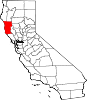
Muir Springs is a former settlement in Mendocino County, California.[1] It was located 4 miles (6.4 km) northeast of Willits.[1]
The springs at the place produced natural gas and sulpherated water.[1]
References
Municipalities and communities of Mendocino County, California Cities Fort Bragg | Point Arena | Ukiah | Willits
CDPs Albion | Anchor Bay | Boonville | Brooktrails | Calpella | Caspar | Cleone | Comptche | Covelo | Hopland | Laytonville | Leggett | Little River | Manchester | Mendocino | Philo | Potter Valley | Redwood Valley | Talmage
Unincorporated
communitiesAlpine | Andersonia | Arnold | Asylum | Bell Springs | Bowman Place | Branscomb | Bredehoft Place | Burbeck | Cameron | Cape Horn | Card Place | Carpenter Place | Clare Mill | Cooks Valley | Crowley | Cubbler Place | Cummings | Dawes | DeCamp | DeHaven | Delmonico Place | Dos Rios | Duncan Springs | Dunlap Place | El Roble | Elk | Fair Oaks | Farley | Fish Rock | Flumeville | Four Pines | Gallaway | Glenblair | Grove | Gualala | Hales Grove | Hardy | Hardy Place | Hays Place | Hearst | Heath Place | Heeser Addition | Hendy Grove | Indian Springs | Inglenook | Ingram | Irmulco | Jim Leggett Place | Kibesillah | Largo | Laughlin | Little Penny | Longvale | Marble Place | Marks Place | McClure Place | Melbourne | Mina | Montgomery | Nacomis Indian Rancheria | Nashmead | Navarro | Newport | Northspur | Noyo | Oasis | Old Bailey Place | Old Hopland | Old Ornbaun Hot Springs | Old Red Rock Place | O'Neil Place | Orrs Springs | Philbrick Mill | Piercy | Pieta | Pine Grove | Pomo | Pratt Place | Presswood | Ralph Leggett Place | Ramsey | Redwood Lodge | Reeves Place | Regina Heights | Reilly Heights | Reyes Place | Ridge | Ridgewood Park | Riverdale | Shake City | Simerson | Soda Springs (Boonville) | Soda Springs (Burbeck) | South Fork | South Leggett | Spyrock | Stronetta | Tan Oak Park | Tatu | The Forks | The Oaks | Twin Rocks | Ukiah Rancheria | Underwood Park | Union Landing | Upp | Vichy Springs | Wanhala | Westport | Whiskey Springs | Whitesboro | Woodman | Yorkville
Indian
reservationsCoyote Valley Reservation | Guidiville Rancheria | Hopland Rancheria | Iverson Indian Rancheria | Manchester-Point Arena Rancheria | Pinoleville Rancheria | Potter Valley Rancheria | Sherwood Valley Rancheria | Redwood Valley Rancheria | Round Valley Indian Reservation
Former
settlementsAnderson | Arthur | Bentley | Bokea | Bucknell | Buldam | Cahto | Carbon | Carey | Chomchadila | Christine | Christine Junction | Clearbrook | Comfort | Crittendon | Dapishul | Dellavan | Duffey | Dunlap | Echo | Empire | En Cimo | Fairbanks | Fountain | Gracy | Half Way | Hardin | Hermitage | Iverson | Junction | Kenny | Lane Redwood Flat | Lema | Masut | Melborne Camp | Moiya | Muir Springs | North Fork House | Northwestern | Noyo Lodge | Ornbaun | Poonkiny | Rankin | Redwine | Reynolds | River Garden | Rockport | Rodgers | Rowes | Salmon Creek | Salsig | Sawyers | Sherburns | Shiegho | Signal Port | Sunnyside | Sylvandale | Tilly | Tolson | Tomki | Tomkiah | Ubakhea | Ulco | Usal | Wendling | Wheeler | Whitehall
Categories:- Former settlements in Mendocino County, California
- Former populated places in California
- Mendocino County, California geography stubs

Wikimedia Foundation. 2010.