- Sierra Nevada (U.S.)
Geobox|Range
name=Sierra Nevada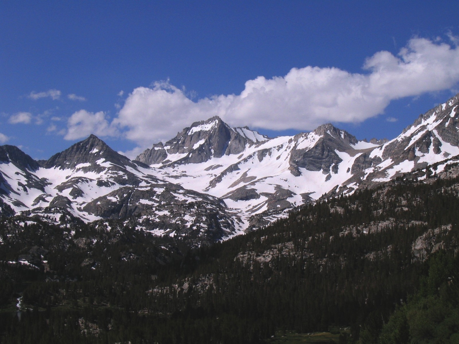
image_size=300
image_caption=Little Lakes Valley: typical eastside terrain
country=United States
state=California| state1=Nevada
parent= | border=
length_imperial=400
length_orientation=North-South
highest=Mount Whitney
highest_elevation_imperial=14505
highest_lat_d=36|highest_lat_m=34|highest_lat_s=42.9|highest_lat_NS=N
highest_long_d=118|highest_long_m=17|highest_long_s=31.2|highest_long_EW=W
geology=batholith| geology1=igneous
period=Triassic
orogeny=
map_size=200
map_caption=Position of Sierra Nevada inside CaliforniaThe Sierra Nevada (Spanish for "Snowy Range") is a
mountain range located in theU.S. state ofCalifornia . In a few places, it overlaps into neighboringNevada . The range is also known informally as the Sierra, the High Sierra, and the Sierras.Geography
The Sierra Nevada stretches 400 miles (650 km), from
Fredonyer Pass in the north toTehachapi Pass in the south.cite web|title=Sierra Nevada|work=Ecological Subregions of California|publisher=United States Forest Service|url=http://www.fs.fed.us/r5/projects/ecoregions/m261e.htm] It is bounded on the west byCalifornia 's Central Valley, and on the east by theGreat Basin .Physiographically, it is a section of the Cascade-Sierra Mountains province, which in turn is part of the larger Pacific Mountain System physiographic division.
In west-east cross section, the Sierra is shaped like a trapdoor: the elevation gradually increases on the west slope, while the east slope forms a steep
escarpment . Thus, the crest runs principally along the eastern edge of the Sierra Nevada range. Rivers flowing west from the Sierra Crest eventually drain into thePacific Ocean , while rivers draining east flow into the Great Basin and do not reach any ocean. [cite web|url=http://www.nps.gov/grba/planyourvisit/the-great-basin.htm|title=The Great Basin|work=Great Basin National Park|publisher=U.S. National Park Service|accessdate=2007-05-12] However, water from several streams and theOwens River is redirected to the city of Los Angeles (seeLos Angeles Aqueduct ). Thus, by artificial means, some east-flowing river water does make it to thePacific Ocean .There are several notable geographical features in the Sierra Nevada:
*Lake Tahoe is a large, clear freshwater lake in the northern Sierra Nevada, with an elevation of 6,225 feet (1,897 m) and an area of 191 square miles (489 km²).cite web|url=http://tahoe.usgs.gov/facts.html|title=Facts about Lake Tahoe|publisher=USGS|accessdate=2007-05-12}] Lake Tahoe lies between the main Sierra and theCarson Range , a spur of the Sierra.
*Hetch Hetchy Valley ,Yosemite Valley , Kings Canyon,Tehipite Valley andKern Canyon are the most well-known of many beautiful, glacially-scoured canyons on the west side of the Sierra.
*Yosemite National Park is filled with stunning features, such as waterfalls andgranite dome s.
*Mount Whitney , at 14,505 feet (4,421 m), [cite web|url=http://www.peakbagging.com/SPS%20BM/GT1811.txt|title=Current Survey Control GT1811|publisher=National Geodetic Survey] is the highest point in thecontiguous United States . Mt. Whitney is on the eastern border ofSequoia National Park .
*Groves ofGiant Sequoia s "Sequoiadendron giganteum" occur along a narrow band of altitude on the western side of the Sierra Nevada. Giant Sequoias are the most massive trees in the world. [cite web|url=http://www.nps.gov/archive/seki/shrm_pic.htm|title=The General Sherman Tree|publisher=U.S. National Park Service]The height of the mountains in the Sierra Nevada gradually increases from north to south. Between Fredonyer Pass and Lake Tahoe, the peaks range from 5,000 feet (1,524 m) to 8,000 feet (2,438 m). The crest near Lake Tahoe is roughly 9,000 feet (2,700 m) high, with several peaks approaching the height of
Freel Peak (10,881 feet, 3,316 m), including Mount Rose (10,776 feet, 3,285 m), which overlooksReno from the north end of theCarson Range . The crest nearYosemite National Park is roughly 13,000 feet (4,000 m) high atMount Dana and Mount Lyell, and the entire range attains its peak atMount Whitney (14,505 feet, 4,421 m). South of Mount Whitney, the range diminishes in elevation, but there are still several high points like Florence Peak (12,405 feet, 3,781 m) andOlancha Peak (12,123 feet, 3,695 m). The range still climbs almost to 10,000 feet (3,048 m) nearLake Isabella , but south of the lake, the peaks reach only to a modest 8,000 feet (2,438 m). [Google Earth images.] [California State map, 2007.]Geology
:See
Geology of the Yosemite area for a detailed article about the geology of the central Sierra Nevada.The well-known granite that makes up most of the southern Sierra started to form in the
Triassic period. At that time, an island arc collided with the West coast ofNorth America and raised a set ofmountain s, in an event called theNevadan orogeny . [cite web|url=http://gorp.away.com/gorp/publishers/wildernesspress/yosemite/hik_yosem25.htm|last=Shaffer|first=Jeffrey|title=Evolution of the Yosemite Landscape — The Nevadan Orogeny|work=One Hundred Hikes in Yosemite] This event producedmetamorphic rock . At roughly the same time, asubduction zone started to form at the edge of the continent. This means that anoceanic plate started to dive beneath theNorth American plate . Magma from the melting oceanic plate rose in plumes (plutons) deep underground, their combined mass forming what is called theSierra Nevada batholith . These plutons formed at various times, from 115 million to 87 million years ago. By 65 million years ago, the proto-Sierra Nevada was worn down to a range of rolling low mountains, a few thousand feet high. Twenty million years ago, crustal extension associated with theBasin and Range Province caused extensive volcanism in the Sierra. [cite web|title=Geologic History of California|url=http://www.geog.ucsb.edu/~joel/g148_f06/readings/geol_history/geol_history.html|author=Joel Michaelsen] About 4 million years ago, the Sierra Nevada started to form and tilt to the west. Rivers started cutting deep canyons on both sides of the range. The Earth's climate cooled, andice age s started about 2.5 million years ago. Glaciers carved out characteristic U-shaped canyons throughout the Sierra. The combination of river and glacier erosion exposed the uppermost portions of the plutons emplaced millions of years before, leaving only a remnant of metamorphic rock on top of some Sierra peaks.Uplift of the Sierra Nevada continues today, especially along its eastern side. This uplift causes large earthquakes, such as the Lone Pine earthquake of 1872.
Ecology
The Sierra Nevada is divided into a number of biotic zonescite book|last=Schoenherr|first=Allan A.|title=A Natural History of California|year=1995|publisher=UC Press|id=ISBN 0-520-06922-6 ]
*ThePinyon pine -Juniper woodland, 5,000-7,000 ft (1,500-2,100 m) east side only
**Notable species:Pinyon Jay ,Desert Bighorn Sheep
*The lower montane forest, 3,000-7,000 ft (1,000-2,100 m) west side, 7,000-8,500 ft (2,100-2,600 m) east side
**Notable species:Ponderosa pine andJeffrey pine ,California black oak ,Incense-cedar ,Giant Sequoia ,Dark-eyed Junco ,Mountain Chickadee ,Western gray squirrel ,Mule deer ,American black bear
*The upper montane forest, 7,000-9,000 ft (2,100-2,700 m) west side, 8,500-10,500 ft (2,600-3,100 m) east side
**Notable species:Lodgepole pine ,Red Fir ,Mountain Hemlock , Sierra Juniper,Hermit Thrush ,Sage Grouse ,Great Grey Owl ,Golden-mantled Ground Squirrel ,Marten
*The subalpine forest, 9,000-10,500 ft (2,700-3,100 m) west side, 10,500-11,500 ft (3,100-3,500 m) east side
**Notable species:Whitebark pine andFoxtail pine ,Clark's Nutcracker
*The alpine region >10,500 ft (>3,100 m) west side, >11,500 ft (>3,500 m) east side
**Notable species:Polemonium viscosum (Sky Pilot),Pika , Belding's ground squirrel,Yellow-Bellied Marmot ,Sierra Nevada Bighorn Sheep History
The earliest identified inhabitants of the Sierra Nevada were the
Paiute tribe on the east side and the Mono and Sierra Miwok tribe on the western side. Today, passes such asDuck Pass are littered with discardedobsidian arrowhead s that date back to trade between tribes. There were also prehistorical territorial disputes between the Paiute and Sierra Miwok tribes [cite journal|last=Hoffmann|first=Charles F.|year=1868|title=Notes on Hetch-Hetchy Valley|journal=Proceedings of the California Academy of Science|volume=1 |issue=3:5|pages=368–370|url= http://www.yosemite.ca.us/library/notes_on_hetch-hetchy_valley.html|accessdate=2006-09-27] Archaeological excavations placedMartis people in northcentral Sierra Nevada during the period of 3,000 BC to 500 AD. Washo andMaidu were also in this area prior to the exploration era. [cite web |url=http://www.sierrarockart.org/makers.html |title=ANCIENT PETROGLYPH MAKERS OF THE NORTHERN SIERRA |accessdate=2008-08-15 |last=Drake |first=Bill |date=2000 |work= |publisher=sierrarockart.org] [cite web |url=http://209.85.141.104/search?q=cache:6-RosF_qtqQJ:www.cityofgrassvalley.com/services/departments/cdd/IdMd/FinalMEAJune2006/405_CulturalRes.pdf+%22martis+tribe%22&hl=en&ct=clnk&cd=14&gl=us&client=firefox-a |title=Prehistoric Context |page=p. 2 |accessdate=2008-08-15 |last= |first= |coauthors= |date=June, 2006 |work=Idaho-Maryland Mine Project, Master Environmental Assessment |publisher=cityofgrassvalley.com]History of exploration
European-American exploration of the mountain range started in the 1840s. In the winter of 1844, Lieutenant
John C. Frémont , accompanied byKit Carson , was the first white man to seeLake Tahoe .By 1860, even though theCalifornia Gold Rush populated the flanks of the Sierra Nevada, most of the Sierra remained unexplored.cite book|last=Roper|first=Steve|title=Sierra High Route: Traversing Timberline Country|year=1997|publisher=The Mountaineers Press|id=ISBN 0-89886-506-9] [cite book|last=Moore|first=James G.|title=Exploring the Highest Sierra|year=2000|publisher=Stanford University Press|id=ISBN 0-8047-3703-7] Therefore, the state legislature authorized theCalifornia Geological Survey to officially explore the Sierra (and survey the rest of the state).Josiah Whitney was appointed to head the survey.Men of the survey, including William H. Brewer,
Charles F. Hoffmann , andClarence King , explored the backcountry of what would becomeYosemite National Park in 1863. In 1864, they explored the area around Kings Canyon. King later recounted his adventures over the Kings-Kern divide in his book "Mountaineering in the Sierra Nevada". In 1871, King mistakenly thought thatMount Langley was the highest peak in the Sierra and climbed it. However, before he could climb the true highest peak (Mount Whitney ), fishermen from Lone Pine climbed it and left a note.Between 1892 and 1897,
Theodore Solomons was the first explorer to attempt to map a route along the crest of the Sierra (what would eventually become theJohn Muir Trail , along a different route). On his 1894 expedition, he took alongLeigh Bierce , son of writerAmbrose Bierce .Other noted early mountaineers included:
*John Muir
*Bolton Coit Brown
*Joseph N. LeConte
*James S. Hutchinson
*Norman Clyde
*Walter Starr, Sr.
*Walter A. Starr, Jr. Features in the Sierra are named after these men.Etymology
In 1542
Juan Rodriguez Cabrillo , sighting theSanta Cruz Mountains while off the peninsula of San Francisco, gave them the name "Sierra Nevada" meaning "snowy range" in Spanish. As more specific names were given to California's coastal ranges, the name was used in a general way to designate less familiar ranges towards the interior. [cite journal |last=Farquhar |first=Francis P. |month=March |year=1925 |title=Exploration of the Sierra Nevada |journal=California Historical Society Quarterly |url=http://www.yosemite.ca.us/library/exploration_of_the_sierra_nevada/] In April of 1776 Padre Pedro Font on the second de Anza expedition, looking northeast across theTulare Lake , described the mountains seen beyond:Looking northeast we saw an immense plain without any trees, through which the water extends for a long distance, having in it several little islands of lowland. And finally, on the other side of the immense plain, and at a distance of about forty leagues, we saw a great Sierra Nevada whose trend appeared to me to be from south-southeast to north-northwest. [citeweb |url=http://anza.uoregon.edu/Action.lasso?-database=fontex&-layout=standard&-op=eq&pg2=186&-response=format/fontexpg2fmt.html&-maxRecords=1000&-noresultserror=/sorry.html&-search |title=4/2/1776 |work=Expanded Diary of Pedro Font |accessyear=2007 |accessmonthday=
February 3 ]Its most common nickname is the "Range of Light". This nickname comes from
John Muir , [cite book|last=Muir|first=John|title=Mountains of California|date=1894|url=http://www.sierraclub.org/john_muir_exhibit/writings/the_mountains_of_california] which is a description of the unusually light colored granite exposed by glacial action.Climate and meteorology
During the fall, winter, and spring, precipitation in the Sierra ranges from convert|20|to|80|in|mm|abbr=on|lk=off where it occurs mostly as snow above convert|6000|ft|m|abbr=on|lk=off. Rain on snow is common. Summers are dry with low humidity, however afternoon thunderstorms are not uncommon. Summer temperature averages 42 to 60 degrees Fahrenheit (5.5 to 15.5 degrees Celsius). The growing season lasts 20 to 230 days, strongly dependent on elevation. [cite web|url=http://www.fs.fed.us/land/pubs/ecoregions/ch33.html|title=Sierran Steppe - Mixed Forest - Coniferous Forest|work=Ecological Subregions of the United States|publisher=US Forest Service|accessdate=2007-01-27]
A unique peculiarity of the Sierra Nevada is that, under certain wind conditions, a large round tube of air begins to roll on the southeast side. This is known as the "Sierra Nevada Rotor" or a "
Sierra Wave " [cite website|title=The Sierra Wave|url=http://www.yosemite.org/naturenotes/sierrawave.htm|work=Nature Notes|publisher=Yosemite Association] . This "mountain wave" forms when dry continental winds from the east cause the formation of a stacked set of counter-revolving cylinders of air reaching into the stratosphere. As of 2004, no sailplane has found its top. Similar features occur on many mountain ranges, but it is often observed and utilized in the Sierra. The phenomenon was the subject of an Air Force-funded study in the early 1950s called the Sierra Wave Project. [cite web|url=http://www.inyokernairport.com/soaring_at_iyk/soaring_at_iyk.html|title=A Brief History of Soaring at Inyokern Airport|last=Ryan|first=Bertha|work=Inyokern Airport Album] Many recent world altitude records set in unpowered aircraft were set in the Sierra Nevada Wave, most flown fromMojave Airport .The Sierra Nevada casts the valleys east of the Sierra in a
rain shadow , which makesDeath Valley andOwens Valley "the land of little rain". [cite book |title=The Land of Little Rain |last=Austin |first=Mary |publisher=University of New Mexico Press |year=1974 |isbn=0826303587]Protected Status
In much of the Sierra Nevada, development is restricted or highly regulated. A complex system of National Forests, National Parks, Wilderness Areas and Zoological Areas designates permitted land uses within the convert|400|mi|km|sing=on stretch of the Sierra. These areas are jointly administered by the
U.S. Forest Service , theBureau of Land Management , and theNational Park Service . SeeList of Sierra Nevada topics for a list of protected areas.ee also
*
List of Sierra Nevada topics , including lists of mountains, rivers, parks, wilderness areas, and other natural features.
*List of books about the Sierra Nevada for further reading
*Ecology of the Sierra Nevada
*List of Sierra Nevada wildfires References
External links
* [http://www.climber.org/data/SierraPeaks.html List of Sierra Peaks at climber.org]
* [http://www.sierraclub.org/john_muir_exhibit/writings/the_mountains_of_california "The Mountains of California"]
* [http://www.nps.gov/yose/education/pdfs/Geo_timeline.pdf Geological Time Line for the Sierra Nevada, National Park Service]
* [http://www.summitpost.org/area/range/176773/sierra-nevada.html Sierra Nevada info at SummitPost]
* [http://www.yosemite.ca.us/library/ Yosemite Online Library (reference material)]
Wikimedia Foundation. 2010.