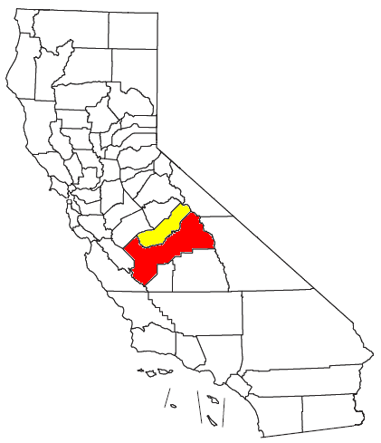
- Metropolitan Fresno
-
Metropolitan Fresno 
Common name: Metropolitan Fresno or Greater FresnoLargest city Fresno Other cities - Clovis
- Madera
- ChowchillaPopulation Ranked 43rd in the U.S. - Total 1,081,315 (2010 census) - Density 133.51 /sq. mi.
51.54 /km²Area 8,099 sq. mi.
20,980 km²State(s) California Elevation - Highest point North Palisade 14,248 feet (4,343 m) - Lowest point Chowchilla 180 feet (54.86 m) Metropolitan Fresno or officially Fresno-Madera, CA CSA is a metropolitan area in California's Central Valley consisting of Fresno and Madera counties in the southern area of Northern California. It is the second largest metropolitan region in the Central Valley, the first being Greater Sacramento, and 42nd largest in the United States as of 2010 census.[1][2]
Metropolitan Fresno is anchored by Fresno, the fifth largest city in California and the 35th largest in the United States. The metropolitan area's Central Valley location, which is one of the world's most productive agricultural regions, allows a large agricultural economy despite being increasingly urbanized.
Contents
Counties
County name Population (2010 U.S. Census) Land area Fresno 930,450 5,963 sq mi (15,440 km2) Madera 150,865 2,136 sq mi (5,530 km2) Metropolitan Fresno 1,081,315 8,099 sq mi (20,980 km2) Overview
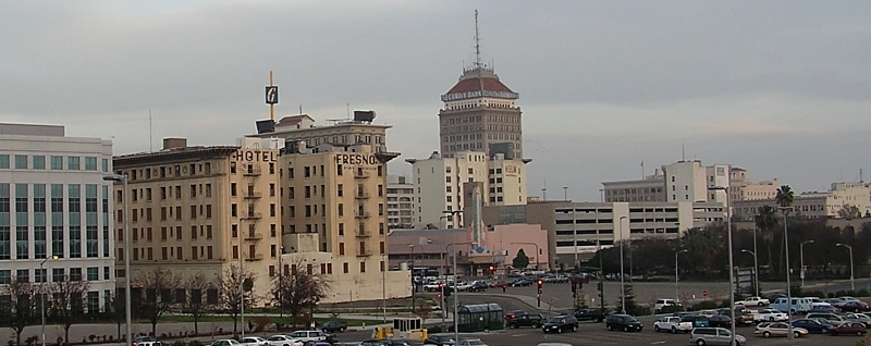
 Downtown Fresno skyline
Metropolitan Fresno, unlike the other metropolitan regions of California, is still largely agricultural and contains a large rural land area and is centered in the San Joaquin Valley. The metropolitan area is located between the larger metropolitan areas of California, bordering the southernmost boundaries of the San Francisco Bay Area in the west and separated from the Greater Sacramento and Greater Los Angeles Areas to the north and south respectively by long distances of rural and farmland. Additionally, the lifestyle and culture of Metropolitan Fresno does not reflect the San Francisco or Sacramento influence as other areas have in Northern California due to distance from the state capital and bordering an unpopulated area of the outskirts of the Bay Area. Instead, Metropolitan Fresno is more influenced by the interior valley region of California although as the area becomes more urbanized, it has become slightly more influenced by the other metropolitan areas of Northern California, particularly the Bay Area.
Fresno is the largest city in the area and in the Central Valley. Along with Sacramento, it is the economic center of California's interior and is one of the fastest growing cities in the United States, with the region having a growth of over 20% since 2000. Additionally, Fresno is a major transportation hub for visitors heading to Yosemite, Kings Canyon National Park and Sequoia National Parks, which are both 60 mi (97 km) and 75 mi (121 km) away from Fresno respectively and Fresno is the nearest major city from the parks. The United States Military has a heavy presence in the Fresno area and numerous divisions are based in Metropolitan Fresno, including the 40th Aviation Brigade and 144th Fighter Wing.[3][4] Fresno County is the largest agricultural county and has the largest concentration of agriculture than any other county in the United States.
Madera County is primarily an agricultural county as well but its cities serve as suburbs of Fresno.
Geography and climate
Geography
Metropolitan Fresno is primarily located in the San Joaquin Valley, which in turn is a part of the larger Central Valley region of California, one of the world's most important agricultural areas. The eastern portions of the area border the Sierra Nevada mountains and the western portions border the Coast Ranges, thus giving the edges of the area higher elevations than the inner valley areas. Several waterways traverse the region, including the San Joaquin and Kings Rivers, Delta–Mendota Canal and Madera Canal. Additionally, the California Aqueduct runs through the area, providing water to crops and is one of the world's longest artificial aqueducts.[5]
Climate
Metropolitan Fresno has a Mediterranean climate (Köppen Csa) with some semi-arid factors due to its interior location (Köppen Bsh), with mild, moderately wet winters and hot and dry summers. December is the coolest month, with an average of 53.4 °F (11.9 °C) during the day in downtown Fresno while summer temperatures can reach 110 °F (43.3 °C) or more. Thick tule fog is present in the valley areas during the winter. Rainfall is most common between December and April while snowfall is sometimes experienced in the higher mountain elevations.
Cities
County seat City County Population (January 1, 2010)[6] Land area[7] Chowchilla Madera 18,698 7.1 sq mi (18 km2) Clovis Fresno 97,218 22.03 sq mi (57.1 km2) Coalinga Fresno 19,065 5.9 sq mi (15 km2) Firebaugh Fresno 6,941 2.8 sq mi (7.3 km2) Fowler Fresno 5,764 2 sq mi (5.2 km2) Fresno Fresno 502,303 104.4 sq mi (270 km2) Huron Fresno 8,062 1.3 sq mi (3.4 km2) Kerman Fresno 14,381 2.2 sq mi (5.7 km2) Kingsburg Fresno 11,504 2.3 sq mi (6.0 km2) Madera Madera 58,243 12.3 sq mi (32 km2) Mendota Fresno 9,966 1.9 sq mi (4.9 km2) Orange Cove Fresno 11,089 1.5 sq mi (3.9 km2) Parlier Fresno 13,658 1.6 sq mi (4.1 km2) Reedley Fresno 26,227 4.4 sq mi (11 km2) Sanger Fresno 25,664 4.7 sq mi (12 km2) San Joaquin Fresno 4,071 1 sq mi (2.6 km2) Selma Fresno 23,435 4.3 sq mi (11 km2) Census-designated places
Transportation
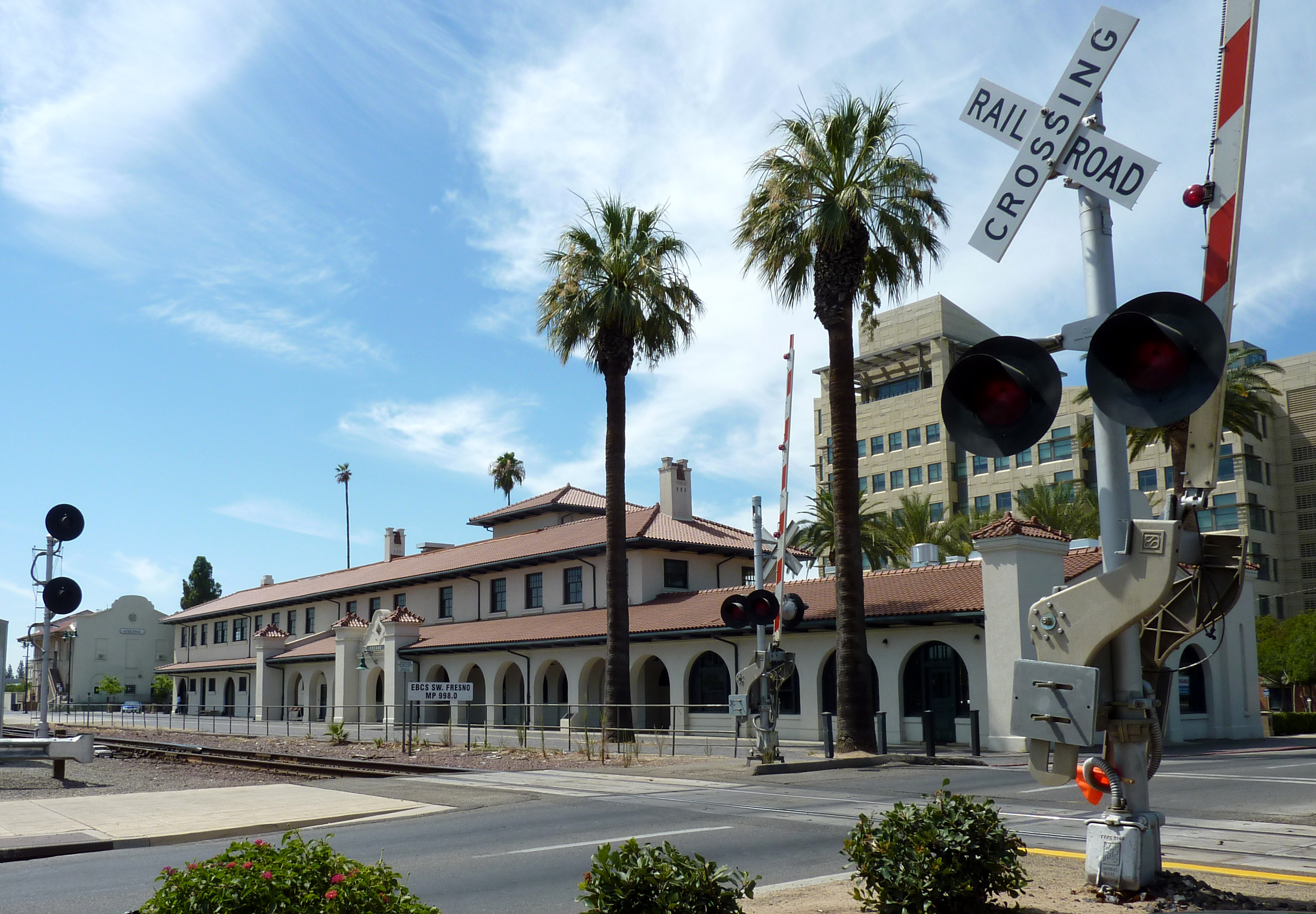
 The Santa Fe Passenger Depot is the largest train station in Metropolitan Fresno.
Owing to its gateway location to numerous national parks as well as being in between the larger Greater Los Angeles and San Francisco Bay Area and Greater Sacramento regions, Metropolitan Fresno serves as a transportation hub in the California interior. However, unlike the larger metropolitan areas of California, Metropolitan Fresno does not have a large public transit system but is served by numerous freeways and highways.
Highways and freeways
Metropolitan Fresno is served by a large number of highways and freeways that are vital in linking the rest of Northern California with Southern California and its location in between the three larger metropolitan areas of the state allows for a large trucking industry as well as services to travelers. Highways and freeways in Metropolitan Fresno include:
Air
The Fresno Yosemite International Airport is the only commercial airport in the region and is a major gateway into Yosemite National Park. Additionally, there are several general aviation airports in the area, including Fresno Chandler Executive Airport, Firebaugh Airport, Sierra Sky Park Airport and Madera Municipal Airport.
Public transit
Metropolitan Fresno's central California location allows it to be a large rail transport center. Two Amtrak rail stations are located in the area, Santa Fe Passenger Depot and Madera which are on the San Joaquin line. Fresno Area Express and Madera County Express serve as bus transit lines connecting to downtown Fresno. Greyhound and Orange Belt Stages provide long distance bus travel to the area.
Politics
See also: Politics of CaliforniaUnlike the other metropolitan areas of California, Metropolitan Fresno has historically been a strong Republican stronghold and the region reflects the Coastal California and interior California divide in which coastal areas and urbanized areas of California tend to lean Democratic while interior areas tend to lean Republican. Exceptions to this are Orange County in Greater Los Angeles, which has been a Republican stronghold since the 1940s, and most of Greater Sacramento, which is a politically competitive area where the major parties are often divided in pluralities although recently there have been Democratic majorities.[8] Metropolitan Fresno has began to become a politically competitive region as well, as in the 2008 presidential election, the region was split with Fresno County going for Barack Obama with the majority of the votes, while John McCain carried Madera County with a comfortable margin. Locally, Democratic concentrations are found in much of Fresno and most non-agricultural suburbs while Republican concentrations are found in Madera County and most rural towns.
References
- ^ U.S. Census Bureau. Census 2000. "Census Demographic Profiles, Fresno County, California" (PDF). CenStats Databases. <http://censtats.census.gov/data/>. http://censtats.census.gov/data/CA/05006019.pdf. Retrieved December 1, 2009.
- ^ U.S. Census Bureau. Census 2000. "Census Demographic Profiles, Madera County, California" (PDF). CenStats Databases. <http://censtats.census.gov/data/>. http://censtats.census.gov/data/CA/05006039.pdf. Retrieved December 1, 2009.
- ^ "Where Are The Divisions". Strategypage.com. November 8, 2004. http://www.strategypage.com/fyeo/howtomakewar/databases/wherearethedivisions.asp. Retrieved July 2, 2010.
- ^ John Pike. "Fresno Air National Guard Base". Globalsecurity.org. http://www.globalsecurity.org/military/facility/fresno.htm. Retrieved July 2, 2010.
- ^ DWR Public Affairs Office (2005). "State Water Project Today". Department of Water Resources, State of California. http://www.publicaffairs.water.ca.gov/swp/swptoday.cfm. Retrieved March 19, 2009.
- ^ "January 2010 Cities Ranked by Size, Numeric and Percent Change" (Adobe Reader). California Department of Finance. http://www.dof.ca.gov/research/demographic/reports/estimates/e-1/2009-10/documents/E-1_2010-Press_Release.pdf. Retrieved May 7, 2010.
- ^ "California – Place: GCT-PH1. Population, Housing Units, Area, and Density: 2000". United States Census Bureau. http://factfinder.census.gov/servlet/GCTTable?_bm=y&-context=gct&-ds_name=DEC_2000_SF1_U&-mt_name=DEC_2000_SF1_U_GCTPH1_ST7&-CONTEXT=gct&-tree_id=4001&-geo_id=04000US06&-format=ST-7. Retrieved February 26, 2010.
- ^ "Supplement to the Statement of Vote: Statewide Summary by County for United States President" (PDF). California Secretary of State. April 10, 2009. http://www.sos.ca.gov/elections/sov/2008_general/ssov/4-pres-statewide-summary-by-county.pdf. Retrieved August 21, 2009.
Categories:- Metropolitan areas of California
- Geography of Fresno County, California
- Geography of Madera County, California
Wikimedia Foundation. 2010.