- California State Route 168
Infobox road
state=CA
type=SR
route=168
alternate_name=Sierra Freeway, Tollhouse Road
section=468
maint=Caltrans 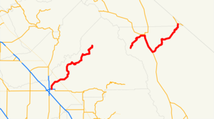
length_mi=124
length_round=2
length_ref= [ [http://www.dot.ca.gov/hq/structur/strmaint/brlog2.htm January 1, 2006 California Log of Bridges on State Highways] ]
established=1934
direction_a=West
terminus_a=jct|state=CA|SR|180 in Fresno
junction=Huntington Lake Lake Sabrina
jct|state=CA|US|395 in Bishop
direction_b=East
terminus_b=jct|state=CA|SR|266 at Oasis
previous_type=SR
previous_route=167
next_type=SR
next_route=169
commons=categoryState Route 168 is a
state highway inCalifornia , USA, which is separated into three distinct segments, in part by the Sierra Nevada mountains.This route is part of the
California Freeway and Expressway System [http://www.leginfo.ca.gov/cgi-bin/displaycode?section=shc&group=00001-01000&file=250-257 CA Codes (shc:250-257)] ] and is eligible for the State Scenic Highway System [http://www.leginfo.ca.gov/cgi-bin/displaycode?section=shc&group=00001-01000&file=260-284 CA Codes (shc:260-284)] ] .Route description
The westernmost segment of SR 168 begins in southeast Fresno at the interchange with State Route 180, where it is known as the Sierra Freeway until it becomes Tollhouse Road near the northeast edge of Clovis. Tollhouse Road is a 4-lane
expressway from the end of the freeway to Shepherd Avenue, east of which the highway is mostly an undivided 2-lane road. This segment continues east up into the Sierra Nevada, ending at Huntington Lake along the western slope of the range.Before the reconstruction of urban SR 168 as a freeway, the route started at SR 41 and Shaw Avenue in Fresno. SR 168 ran along Shaw Avenue, Clovis Avenue, Third Street (Clovis), and Tollhouse Road to the current end of the freeway.
SR 168 cannot be used to cross the Sierra Nevada. The closest crossings of the Sierra Nevada are SR 120 via
Tioga Pass to the north (warmer months only) and SR 178 viaWalker Pass to the south.The middle segment of SR 168 has its western terminus at Lake Sabrina on the eastern slope of the Sierra Nevada. This
rural mountain road runs east toUS Highway 395 in Bishop.The easternmost segment of SR 168 begins in Big Pine at US 395, and climbs into the White Mountains through
Westgard Pass , passing theAncient Bristlecone Pine Forest . From here it traversesDeep Springs Valley , home ofDeep Springs College , before crossing intoFish Lake Valley , where the segment ends at State Route 266, just west of theNevada Border.Major intersections and exit list
:"Note: Except where prefixed with a letter,
postmile s were measured in 1964, based on the alignment as it existed at that time, and do not necessarily reflect current mileage. The numbers reset at county lines; the start and end postmiles in each county are given in the county column."References
External links
* [http://www.westcoastroads.com/california/ca-168.html California @ WestCoastRoads.com - State Route 168]
* [http://www.dot.ca.gov/hq/roadinfo/sr168 Caltrans: Route 168 highway conditions]
* [http://www.cahighways.org/161-168.html#168 California Highways: Route 168]

Wikimedia Foundation. 2010.