California State Route 161
- California State Route 161
Infobox road
state=CA
type=SR
route=161
section=461
maint=Caltrans
length_mi=19.36
length_round=2
length_ref= [ [http://www.dot.ca.gov/hq/structur/strmaint/brlog2.htm January 1, 2006 California Log of Bridges on State Highways] ]
direction_a=West
terminus_a=jct|state=CA|US|97 near Dorris
direction_b=East
terminus_b=jct|state=CA|SR|139 near Tulelake
previous_type=SR
previous_route=160
next_type=SR
next_route=162
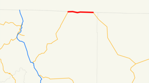
State Route 161 is a California state highway running along the California-Oregon state line from U.S. Route 97 north of Dorris to the intersection of Route 139 and Oregon Route 39 north of Tulelake. Route 161 is part of the Volcanic Legacy Scenic Byway.
This route is eligible for the State Scenic Highway System[ [http://www.leginfo.ca.gov/cgi-bin/displaycode?section=shc&group=00001-01000&file=260-284 CA Codes (shc:260-284)] ] .]Major intersections
:"Note: Except where prefixed with a letter, postmiles were measured in 1964, based on the alignment as it existed at that time, and do not necessarily reflect current mileage."The entire route is in Siskiyou County.
External links
* [http://www.dot.ca.gov/hq/roadinfo/sr161 Caltrans: Route 161 highway conditions]
* [http://www.cahighways.org/161-168.html#161 California Highways: Route 161]
References
Wikimedia Foundation.
2010.
Look at other dictionaries:
Nevada State Route 161 — State Route 161 Goodsprings Road Route information Maintained by NDOT Length … Wikipedia
California State Route 160 — State Route 160 North Sacramento Freeway, River Road … Wikipedia
Utah State Route 161 — Infobox road state=UT type=SR route=161 section=122 maint=UDOT map notes=SR 161 in red length mi=3.084 length round=3 length ref=cite web|url=http://www.dot.utah.gov/main/uconowner.gf?n=15544415950754746|title=Route 161|work=… … Wikipedia
California State Route 139 — Infobox road state=CA type=SR route=139 section=439 maint=Caltrans length mi=121.836 length round=3 length ref= length notes=(plus about 21 mi (34 km) on SR 299) history=State highway in ca. 1940 and 1959; numbered by 1946 direction a=South… … Wikipedia
California State Route 162 — Infobox road state=CA type=SR route=162 section=462 maint=Caltrans length mi= length round= length ref=fact established= direction a=West terminus a=jct|state=CA|US|101 at Longvale junction=jct|state=CA|FH|7|nolink1=yes near Covelo… … Wikipedia
California State Route 19 — Infobox road state=CA type=SR route=19 section=319 and 464 maint=Caltrans alternate name=Lakewood Boulevard, Rosemead Boulevard length mi=26.2 length ref= [California Department of Transportation, [http://web.archive.org/web/20040306063946/http://… … Wikipedia
California State Route 168 — Infobox road state=CA type=SR route=168 alternate name=Sierra Freeway, Tollhouse Road section=468 maint=Caltrans length mi=124 length round=2 length ref= [ [http://www.dot.ca.gov/hq/structur/strmaint/brlog2.htm January 1, 2006 California Log of… … Wikipedia
California State Route 163 — Infobox road state=CA type=SR route=163 section=463 maint=Caltrans alternate name=Cabrillo Freeway length mi=11 length round=0 length ref= [http://www.dot.ca.gov/hq/structur/strmaint/brlog2.htm January 1, 2006 California Log of Bridges on State… … Wikipedia
California State Route 167 — Infobox road state=CA type=SR route=167 section=467 maint=Caltrans length mi=21 length round=0 length ref=Fact|date=January 2008 direction a=West terminus a=jct|state=CA|US|395 at Lundy direction b=East terminus b=jct|state=NV|SR|359 towards… … Wikipedia
Nevada State Route 163 — State Route 163 Laughlin Highway Route information Maintained by NDOT Length … Wikipedia
