- Utah State Route 161
Infobox road
state=UT
type=SR
route=161
section=122
maint=UDOT 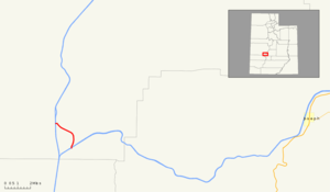
map_notes=SR-161 in red
length_mi=3.084
length_round=3
length_ref=cite web|url=http://www.dot.utah.gov/main/uconowner.gf?n=15544415950754746|title=Route 161|work= [http://www.udot.utah.gov/main/f?p=100:pg:3977778294530221:::1:T,V:814 Highway Reference] |publisher=Utah Department of Transportation |accessdate=2008-09-30|date=May 2008|format=PDF]
established=1965
direction_a=South
terminus_a=jct|state=UT|I|70 nearCove Fort
junction=jct|state=UT|I|15 near Cove Fort
direction_b=North
terminus_b=Black Rock Road near Cove Fort
counties=Millard
previous_type=SR
previous_route=160
next_type=SR
next_route=162 State Route 161 (SR-161) is a 3.084 mile longstate highway completely within Millard County in centralUtah . The highway connects Interstate 70 (I-70) to I-15 while providing service to historic Cove Fort. The route use to be part ofU.S. Route 91 (US-91), but was renumbered to SR-161 in 1965, in parallel with the construction of I-15.Route description
Located entirely in southeastern Millard County,cite map |publisher=Utah Department of Transportation |title=General Highway Map - Millard County |url=http://www.udot.utah.gov/main/f?p=100:pg:295315469568359600::::V,T:,364 |year=2005 |page=6 |accessdate=2008-09-30] SR-161 starts at a
diamond interchange with exit 1 of I-70. The road continues northerly until it reaches the historicalCove Fort and the associated visitors center. On the east is aUtah Department of Transportation (UDOT) maintenance center. SR-161 starts to make a gentle turn to the north-northeast, and passes by a Chevronfilling station , which is also serving as a contracted UDOTrest area . The highway intersects I-15 and comes to an end at a cattle guard on Black Rock Road.cite map |publisher=Google Maps |title=SR-161 Overview |url=http://maps.google.com/maps?f=d&saddr=38.615772,-112.612106&daddr=UT-161&hl=en&geocode=%3BFXXITAIdqRhK-Q&mra=dme&mrcr=0&mrsp=0&sz=18&sll=38.61589,-112.612267&sspn=0.001622,0.003964&ie=UTF8&ll=38.602249,-112.600765&spn=0.051917,0.175781&t=h&z=13 |cartography=Tele Atlas |accessdate=2008-09-30]For the year 2007, a daily average of 455 cars traveled along SR-161, representing only a slight growth from previous years (in 2006, the average was 450; in 2005, 415).cite web|url=http://www.udot.utah.gov/main/uconowner.gf?n=2363711025498494585|format=PDF|title=Traffic on Utah Highways - 2007|date=2008-07-02|publisher=Utah Department of Transportation|pages=|accessdate=2008-09-30] Thirty five percent of this traffic was composed of trucks.cite web|url=http://www.udot.utah.gov/main/uconowner.gf?n=2363733707060508179|format=PDF|title=Truck Traffic on Utah Highways - 2007|date=2008-07-02|publisher=Utah Department of Transportation|pages=|accessdate=2008-09-30] The average traffic measurement is collected at a point on SR-161 between Cove Fort and the interchange with I-15.
History
The SR-161 designation has been used two other times for other state routes. The first route, which was active between 1933 and 1953 and connected SR-1 to SR-68 in Bluffdale. From May 8, 1961 to February 14, 1964, the route number was used for a road from SR-1 to I-15.
The current route, formed in 1965, renumbered the highway through Cove Fort from US-91 to SR-161, as US-91 was removed, and I-15 was built west of Cove Fort. US-91 before the formation of I-15 was the major thoroughfare through Utah, connecting it to California and Montana.cite map |publisher=
United States Department of Agriculture |title=United States System of Highways |url=http://upload.wikimedia.org/wikipedia/commons/5/55/1926us.jpg|year=1926 |accessdate=2008-09-26] No significant changes have been made to the roadway except for its legal definition.cite web|url=http://www.dot.utah.gov/main/uconowner.gf?n=200609190933291|title=Route 161|date=November 2007|work= [http://www.udot.utah.gov/main/f?p=100:pg:3977778294530221:::1:T,V:1348 Highway Resolutions] |publisher=Utah Department of Transportation|accessdate=2008-09-30|format=PDF] SR-161 serves the important function of providing access to the contracted rest area as well as the historic Cove Fort.Major intersections
References

Wikimedia Foundation. 2010.