- Utah State Route 68
Infobox road
state=UT
type=SR
route=68
section=112
maint=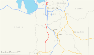
length_mi=70.832
length_round=3
length_ref=cite web
url=http://www.dot.utah.gov/main/uconowner.gf?n=6731124843241837
title=Route 68
format=PDF
date=March 2005
accessdate=2008-01-29
publisher=Utah Department of Transportation
work= [http://www.udot.utah.gov/main/f?p=100:pg:3977778294530221:::1:T,V:814, Highway Reference] ]
established=1931
direction_a=South
terminus_a=jct|state=UT|US|6 near Elberta
junction=jct|state=UT|SR|154 in Bluffdale
jct|state=UT|I|215 in Taylorsville
jct|state=UT|SR|201 in Salt Lake City
jct|state=UT|I|80 in Salt Lake City
jct|state=UT|I|215 in North Salt Lake
jct|state=UT|I|15 in Bountiful
direction_b=North
terminus_b=jct|state=UT|US|89 in Bountiful
previous_type=SR
previous_route=67
next_type=I
next_route=70State Route 68 (SR-68) is a
state highway in the U.S. state ofUtah . It is a major thoroughfare throughout theWasatch Front as it runs north–south for convert|70.832|mi|km|3, linking U.S. Route 6 (US-6) to all of the major freeways and highways in theSalt Lake City metropolitan area . The route is more commonly referred to as Redwood Road, after the street it is routed along throughout Salt Lake County. The highway is also routed for a short distance along 500 South and 200 West in Bountiful and Camp Williams Road in Utah County. The route is a surface street for its entire length.Route description
On average, the most driven-on portion of SR-68 is between I-215 and 5400 South, with 66,635 cars-per-day traveling between these two points in 2007. The lowest traffic is recorded at the beginning point of the route through Elberta, with an average of 1,120 cars per day.cite web|url=http://www.udot.utah.gov/main/uconowner.gf?n=2363711025498494585|title=2007 Traffic on Utah Highways|publisher=
Utah Department of Transportation |accessdate=2008-08-27|format=PDF] Traffic along SR-68 in Elberta has increased 135 percent, and the segment between I-215 and 5400 West has increased 13 percent since 1998.cite web|url=http://www.udot.utah.gov/main/uconowner.gf?n=200309161130012|title=Traffic on Utah's Highways 2000|publisher=Utah Department of Transportation |accessdate=2008-08-27|format=PDF]Utah County
A four-way intersection in Elberta with US-6 marks the southern terminus of the route as it starts north on a two-lane undivided highway. The highway exits Elberta and continues north along the sparsely-populated portion of western Utah County. The southwestern shore of
Utah Lake appears as the road briefly turns northeast. The route passes the failedplanned community of Mosida before turning north again. Once more turning northeast, the highway approaches the western shore of the lake and runs parallel to it before once more turning north. After turning northwest, the highway enters Saratoga Springs. In the center of town, the road passes west of Talons Cove Golf Course. Exiting the community, the route turns north near Utah Lake's northern shore and intersects with SR-73 west of Lehi and east of Eagle Mountain. Past this intersection, the route turns northwest and passes slightly east ofCamp Williams .cite web
url=http://maps.google.com/maps?f=q&hl=en&geocode=&q=Salt+Lake+City&ie=UTF8&ll=40.721941,-111.936758&spn=0.011953,0.014248&z=16&iwloc=addr
title=Google Maps|accessdate=2008-08-11|publisher=Google Inc.]Salt Lake County
The highway then enters Salt Lake County and the
Salt Lake City metropolitan area . SR-68 is one of two roads that connect Utah and Salt Lake Counties through a bottleneck in theWasatch Front called Point of the Mountain, referring to theTraverse Mountains .cite web
url = http://www.media.utah.edu/UHE/s/SANDY.html|title = Utah History Encyclopedia - Sandy|publisher = University of Utah press|first = Martha Sonntag|accessdate=2008-08-22|last = Martha Sonntag Bradley] The low lying area through this neck is occupied by the formerDenver and Rio Grande Western Railroad . SR-68 is routed on the western slope of the canyon, The other highway, Interstate 15 (I-15)/US-89, is routed higher up Point of the Mountain. As the route enters Bluffdale on Redwood Road, it turns northeast and intersects with SR-140; theUtah State Prison is located on this road east of the junction. SR-68 then turns north and widens to four lanes before crossing SR-154, commonly known as the Bangerter Highway. Soon reverting to two lanes, the route exits Bluffdale and enters Riverton, gaining two lanes in each direction as it passes SR-71. Continuing north, it enters South Jordan. It intersects with SR-151 and SR-209, gaining one more lane in each direction beyond the latter intersection, and enters West Jordan and central Salt Lake County.Soon reaching Taylorsville, the highway intersects I-215. Shortly thereafter, the road passes
Salt Lake Community College and enters West Valley City. It soon reaches asingle-point urban interchange at SR-201 that lies on the border of West Valley City and Salt Lake City. The highway then passes west of Glendale Golf Course and loses one lane in each direction past the frontage road of SR-201. West of Salt Lake City, the highway passes over the surplus canal of the Jordan River as it goes through the neighborhoods of Glendale and Poplar Grove. It arrives at an interchange with I-80 east ofSalt Lake City International Airport . The road loses one lane northbound beyond 1000 North as it proceeds through the neighborhood of Rose Park in the northwestern portion of the city; the second southbound lane is lost north of 1300 North. The highway passes the Jordan River and Rose Park Golf Courses, crossing the Jordan River before exiting the county.Davis County
Entering Davis County and North Salt Lake, SR-68 reaches a second interchange with I-215 at its exit 28. The road briefly turns northeast before drifting north again and gaining one lane in each direction. Before passing
Skypark Airport , the highway loses one lane in each direction. Redwood Road turns east onto 500 South and enters Bountiful. Past an interchange at I-15, the route gains one passing lane and turns south onto 200 West, a two-lane undivided road. The highway turns southwest and defaults onto southbound US-89.History
In 1931, the state legislature added State Route 68 to the state highway system. It followed Redwood Road from SR-67 (North Temple Street) south to the present SR-73 and then used SR-73 east to SR-1 (US-91, now US-89) in Lehi. [cite UTSR law|year=1931|quote=(68) From junction with route 67 southerly via Redwood road in Salt Lake county to Lehi in Utah county.] The state added 900 West and Warm Springs Road from SR-67 north to SR-1 at Becks as State Route 153 in 1933. [cite UTSR law|year=1933|chapter=30|quote=(153) From North Temple and Eighth West street northerly to route 91 at Becks.] Becks is the name of a
rail siding , convert|4|mi|km|0 north of downtown Salt Lake, that briefly served as the terminus of a commuter rail line to Beck's Hot Springs.cite book | last=Carr | first=Stephen L. | coauthors=Edwards, Robert W. | title=Utah Ghost Rails | origdate=1989 | publisher=Western Epics | location=Salt Lake City, Utah | language=English | isbn=0-914740-34-2 | pages=Pages 32 | chapter=Bamberger Railroad ] In 1943 Route 153 was moved west to Redwood Road, returning to Becks via 2300 North. [cite UTSR law|year=1943|quote=Route 153. From route 67 on Redwood Road north to Junction with route 1 near Davis-Salt Lake County line.] This brought the north end of SR-68 and the south end of SR-153 together, and two years later SR-68 was extended north to absorb SR-153. [cite UTSR law|year=1945|quote=Route 68. From route 1 near Beck's Hot Springs southerly via Redwood Road and Camp Williams to Lehi on route 1.] In 1953, Redwood Road north of 2300 North became State Route 249, which turned east at 500 South in Davis County to end at SR-1 (500 West) in Bountiful. [cite UTSR law|year=1953|quote=Route 249. From route 68 at Redwood Road west of Beck's Hot Springs northerly and easterly to route 1 on Fifth South Street in Bountiful.]To provide for route continuity on a truck
bypass route of Salt Lake City, SR-68 and SR-249 were swapped in 1960, bringing the north end of SR-68 to Bountiful and making SR-249 a short connection on 2300 North.cite web|url=http://www.udot.utah.gov/main/uconowner.gf?n=200609201344431|title=Route 249|date=November 2007|publisher=Utah Department of Transportation |accessdate=2008-01-30|format=PDF|work= [http://www.udot.utah.gov/main/f?p=100:pg:3977778294530221:::1:T,V:1348,Highway Highway Resolutions] ] At the same time, SR-68 was extended south from the intersection with SR-73 around the west side ofUtah Lake to SR-26 at Elberta, with the portion east to Lehi becoming an extension of SR-73.cite web|url=http://www.udot.utah.gov/main/uconowner.gf?n=200609181035091|title=Route 68|date=November 2007|publisher=Utah Department of Transportation |accessdate=2008-01-30|format=PDF|work= [http://www.udot.utah.gov/main/f?p=100:pg:3977778294530221:::1:T,V:1348,Highway Highway Resolutions] ] SR-249 was extended west along a proposed roadway to 2200 West and 2200 North in 1961, "in order to provide an adequate road from the north to the Salt Lake City municipal airport", but in 1969 the entire route was removed from the state highway system. SR-68 was extended slightly east at its north end, from 500 West (US-89) to 200 West (SR-106), in 1975 , and, in 2001, with the removal of SR-106 through downtown Bountiful from the state highway system, SR-68 was extended south along 200 West, formerly SR-106, to Parkin Junction on US-89.When the highway was established in 1931, it ran from Lehi to Salt Lake City. The state subsequently extended it south into Elberta and north into Bountiful. The road was routed along its current alignment of Redwood Road in 1943. The road has been moved and extended multiple times, with the most recent change being in 2001 when SR-106 was deleted from the state highway system. Currently a construction project is underway to widen Redwood Road to 4 lanes and a center turn lane between 10400 South and 12600 south in Riverton. Improvements also include wider medians with bicycle lanes, and sidewalks.cite web|url=http://www.udot.utah.gov/main/f?p=100:pg:188029639545366:::1:T,V:856,37378|title=Redwood Road, 10400 to 12600 South – South Jordan and Riverton|date=2008-08-07|publisher=
Utah Department of Transportation |accessdate=2008-08-27]Major intersections
References

Wikimedia Foundation. 2010.