- North Salt Lake, Utah
-
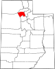
North Salt Lake, Utah — City — North Salt Lake City Hall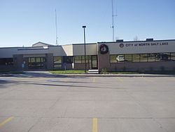 Location of North Salt Lake, Utah
Coordinates: 40°50′45″N 111°54′25″W / 40.84583°N 111.90694°WCoordinates: 40°50′45″N 111°54′25″W / 40.84583°N 111.90694°W Country United States State Utah County Davis Incorporated 1946 Named for Great Salt Lake Area – Total 8.2 sq mi (21.4 km2) – Land 8.2 sq mi (21.4 km2) – Water 0.0 sq mi (0.0 km2) Elevation 4,334 ft (1,321 m) Population (2000) – Total 8,749 – Density 1,060.7/sq mi (409.5/km2) Time zone Mountain (MST) (UTC-7) – Summer (DST) MDT (UTC-6) ZIP code 84054 Area code(s) 801 FIPS code 49-55210[1] GNIS feature ID 1443971[2] North Salt Lake is a city in Davis County, Utah, United States. It is part of the Ogden–Clearfield, Utah Metropolitan Statistical Area. The population was 8,749 at the 2000 census.
Contents
Geography
North Salt Lake is located at 40°50′45″N 111°54′25″W / 40.84583°N 111.90694°W (40.845895, -111.906925).[3]
According to the United States Census Bureau, the city has a total area of 8.2 square miles (21.4 km²), all of it land.
Demographics
Historical populations Census Pop. %± 1950 255 — 1960 1,655 549.0% 1970 2,143 29.5% 1980 5,548 158.9% 1990 6,474 16.7% 2000 8,749 35.1% As of the census[1] of 2000, there were 8,749 people, 2,874 households, and 2,253 families residing in the city. The population density was 1,060.7 people per square mile (409.5/km²). There were 3,022 housing units at an average density of 366.4 per square mile (141.4/km²). The racial makeup of the city was 92.60% White, 0.31% African American, 1.01% Native American, 1.50% Asian, 0.42% Pacific Islander, 2.40% from other races, and 1.76% from two or more races. Hispanic or Latino of any race were 6.36% of the population.
There were 2,874 households out of which 42.6% had children under the age of 18 living with them, 64.3% were married couples living together, 9.4% had a female householder with no husband present, and 21.6% were non-families. 16.7% of all households were made up of individuals and 5.4% had someone living alone who was 65 years of age or older. The average household size was 3.04 and the average family size was 3.46.
In the city the population was spread out with 31.9% under the age of 18, 13.0% from 18 to 24, 29.2% from 25 to 44, 18.1% from 45 to 64, and 7.7% who were 65 years of age or older. The median age was 28 years. For every 100 females there were 102.1 males. For every 100 females age 18 and over, there were 99.4 males.
The median income for a household in the city was $47,052, and the median income for a family was $52,485. Males had a median income of $40,101 versus $26,223 for females. The per capita income for the city was $21,544. About 3.0% of families and 3.3% of the population were below the poverty line, including 3.6% of those under age 18 and 2.3% of those age 65 or over.
References
- ^ a b "American FactFinder". United States Census Bureau. http://factfinder.census.gov. Retrieved 2008-01-31.
- ^ "US Board on Geographic Names". United States Geological Survey. 2007-10-25. http://geonames.usgs.gov. Retrieved 2008-01-31.
- ^ "US Gazetteer files: 2010, 2000, and 1990". United States Census Bureau. 2011-02-12. http://www.census.gov/geo/www/gazetteer/gazette.html. Retrieved 2011-04-23.
External links
Municipalities and communities of Davis County, Utah Cities Bountiful | Centerville | Clearfield | Clinton | Farmington | Fruit Heights | Kaysville | Layton | North Salt Lake | South Weber | Sunset | Syracuse | West Bountiful | West Point | Woods Cross
 Categories:
- Wasatch Front
- Cities in Utah
- Populated places in Davis County, Utah
- Ogden–Clearfield metropolitan area


Wikimedia Foundation. 2010.