- Ogden–Clearfield metropolitan area
-
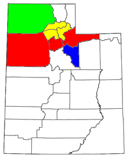 Map of the Salt Lake City-Ogden-Clearfield CSA, with the Ogden-Clearfield Metropolitan Statistical Area highlighted in yellow
The Ogden-Clearfield Metropolitan Statistical Area, as defined by the United States Census Bureau, is an area consisting of three counties in north central Utah, anchored by the cities of Ogden and Clearfield. As of the 2000 census, the MSA had a population of 442,646, and a July 1, 2009 estimate placed the population at 541,569.[1]
Contents
Counties
Communities
- Bountiful
- Centerville
- Clearfield
- Clinton
- Croydon (unincorporated)
- Eden (unincorporated)
- Farmington
- Farr West
- Fruit Heights
- Harrisville
- Hooper
- Huntsville
- Kaysville
- Layton
- Liberty (unincorporated)
- Marriott-Slaterville
- Monte Verde (unincorporated)
- Morgan
- Mountain Green (unincorporated)
- Nordic Valley (unincorporated)
- North Ogden
- North Salt Lake
- Ogden
- Peterson (unincorporated)
- Plain City
- Pleasant View
- Reese (unincorporated)
- Richville (unincorporated)
- Riverdale
- Roy
- South Ogden
- South Weber
- Stoddard (unincorporated)
- Sunset
- Syracuse
- Taylor (unincorporated)
- Uintah
- Warren (unincorporated)
- Washington Terrace
- West Bountiful
- West Haven
- West Point
- West Weber (unincorporated)
- Woods Cross
Demographics
As of the census[2] of 2000, there were 442,646 people, 138,945 households, and 110,557 families residing within the MSA. The racial makeup of the MSA was 90.32% White, 1.21% African American, 0.66% Native American, 1.40% Asian, 0.22% Pacific Islander, 4.17% from other races, and 2.02% from two or more races. Hispanic or Latino of any race were 8.57% of the population.
The median income for a household in the MSA was $49,338, and the median income for a family was $53,806. Males had a median income of $39,834 versus $24,553 for females. The per capita income for the MSA was $18,479.
See also
References
- ^ "Table 1. Annual Estimates of the Population of Metropolitan and Micropolitan Statistical Areas: April 1, 2000 to July 1, 2009 (CBSA-EST2009-01)" (CSV). 2009 Population Estimates. United States Census Bureau, Population Division. 2010-03-23. http://www.census.gov/popest/metro/tables/2009/CBSA-EST2009-01.csv. Retrieved 2010-03-26.
- ^ "American FactFinder". United States Census Bureau. http://factfinder.census.gov. Retrieved 2008-01-31.
 State of UtahSalt Lake City (capital)
Topics - Cities
- Congressional districts
- Counties
- Flag
- Geography
- Government
- Governors
- History
- People
- Portal
- Symbols
- Visitor Attractions
Society - Demographics
- Economy
- Politics
Regions Largest cities - American Fork
- Bountiful
- Cedar City
- Clearfield
- Cottonwood Heights
- Draper
- Holladay
- Kaysville
- Layton
- Lehi
- Logan
- Midvale
- Murray
- Ogden
- Orem
- Pleasant Grove
- Provo
- Riverton
- Roy
- St. George
- Salt Lake City
- Sandy
- South Jordan
- South Salt Lake
- Spanish Fork
- Springville
- Taylorsville
- Tooele
- West Jordan
- West Valley City
Counties Attractions Categories:- Ogden–Clearfield metropolitan area
- Populated places in Davis County, Utah
- Populated places in Morgan County, Utah
- Populated places in Weber County, Utah
- Wasatch Front
Wikimedia Foundation. 2010.