- Morgan County, Utah
-
Morgan County, Utah 
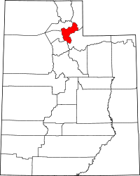
Location in the state of Utah
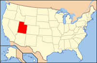
Utah's location in the U.S.Founded 1862 Named for Jedediah Morgan Grant Seat Morgan Largest city Morgan Area
- Total
- Land
- Water
611 sq mi (1,582 km²)
609 sq mi (1,578 km²)
2 sq mi (4 km²), 0.27%Population
- (2010)
- Density
9,469
15.5/sq mi (6/km²)Morgan County is a county located in the U.S. state of Utah. As of 2010 the population was 9,469. It was named for Jedediah Morgan Grant, father of Heber J. Grant, who served as president of the Church of Jesus Christ of Latter-day Saints. Its county seat and largest city is Morgan.[1]
Morgan County is part of the Ogden–Clearfield Metropolitan Statistical Area as well as the Salt Lake City–Ogden–Clearfield Combined Statistical Area.
Contents
History
An early route of the Hastings Cutoff ran through the Morgan Valley and down through a narrow gorge in Weber Canyon. The Donner Party avoided going through the Morgan Valley in order to speed up their journey. However, their alternate route proved more time-consuming.
In 1855, Charles Shreeve Peterson and his family became the first white settlers to take up permanent residence in the Morgan Valley after cutting a road through Weber Canyon.
Geography
According to the U.S. Census Bureau, the county has a total area of 611 square miles (1,580 km2), of which 609 square miles (1,580 km2) is land and 2 square miles (5.2 km2) (0.27%) is water.
Major highways
Adjacent counties
- Weber County, Utah - (north)
- Summit County, Utah - (east)
- Salt Lake County, Utah - (southwest)
- Davis County, Utah - (west)
- Rich County, Utah - (northeast)
National protected areas
- Cache National Forest (part)
- Wasatch National Forest (part)
Demographics
Historical populations Census Pop. %± 1870 1,972 — 1880 1,783 −9.6% 1890 1,780 −0.2% 1900 2,045 14.9% 1910 2,467 20.6% 1920 2,542 3.0% 1930 2,536 −0.2% 1940 2,611 3.0% 1950 2,519 −3.5% 1960 2,837 12.6% 1970 3,983 40.4% 1980 4,917 23.4% 1990 5,528 12.4% 2000 7,129 29.0% 2010 9,469 32.8% Source: US Census Bureau As of the census[2] of 2000, there were 7,129 people, 2,046 households, and 1,782 families residing in the county. The population density was 12 people per square mile (5/km²). There were 2,158 housing units at an average density of 4 per square mile (1/km²). The racial makeup of the county was 98.11% White, 0.04% Black or African American, 0.18% Native American, 0.15% Asian, 0.45% from other races, and 1.07% from two or more races. 1.44% of the population were Hispanic or Latino of any race.
There were 2,046 households out of which 49.70% had children under the age of 18 living with them, 79.60% were married couples living together, 5.60% had a female householder with no husband present, and 12.90% were non-families. 11.70% of all households were made up of individuals and 5.80% had someone living alone who was 65 years of age or older. The average household size was 3.48 and the average family size was 3.81.
In the county, the population was spread out with 37.10% under the age of 18, 9.70% from 18 to 24, 24.30% from 25 to 44, 20.20% from 45 to 64, and 8.70% who were 65 years of age or older. The median age was 28 years. For every 100 females there were 102.90 males. For every 100 females age 18 and over, there were 99.70 males.
The median income for a household in the county was $50,273, and the median income for a family was $53,365. Males had a median income of $42,350 versus $23,036 for females. The per capita income for the county was $17,684. About 3.70% of families and 5.20% of the population were below the poverty line, including 5.70% of those under age 18 and 6.90% of those age 65 or over.
Cities and towns
- Croydon
- Monte Verde
- Morgan
- Mountain Green
- Peterson
- Porterville
- Richville
- Stoddard
See also
References
- ^ "Find a County". National Association of Counties. http://www.naco.org/Counties/Pages/FindACounty.aspx. Retrieved 2011-06-07.
- ^ "American FactFinder". United States Census Bureau. http://factfinder.census.gov. Retrieved 2008-01-31.
Further reading
- Smith, Linda H. (1999). A History of Morgan County. Salt Lake City, UT: Utah State Historical Society. ISBN 9780913738368.
External links

Weber County Rich County 
Davis County 
Summit County  Morgan County, Utah

Salt Lake County Municipalities and communities of Morgan County, Utah City CDP Unincorporated
communitiesCroydon | Peterson | Porterville
 State of Utah
Topics - Cities
- Congressional districts
- Counties
- Flag
- Geography
- Government
- Governors
- History
- People
- Portal
- Symbols
- Visitor Attractions
Society - Demographics
- Economy
- Politics
Regions Largest cities - American Fork
- Bountiful
- Cedar City
- Clearfield
- Cottonwood Heights
- Draper
- Holladay
- Kaysville
- Layton
- Lehi
- Logan
- Midvale
- Murray
- Ogden
- Orem
- Pleasant Grove
- Provo
- Riverton
- Roy
- St. George
- Salt Lake City
- Sandy
- South Jordan
- South Salt Lake
- Spanish Fork
- Springville
- Taylorsville
- Tooele
- West Jordan
- West Valley City
Counties Attractions Categories:- Utah counties
- Populated places established in 1862
- Morgan County, Utah
- Ogden–Clearfield metropolitan area
Wikimedia Foundation. 2010.

