- Millard County, Utah
-
Millard County, Utah 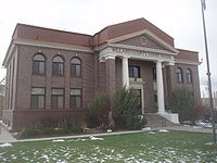 Old Millard County courthouse
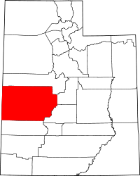
Location in the state of Utah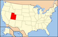
Utah's location in the U.S.Founded 1852 Named for Millard Fillmore Seat Fillmore Largest city Delta Area
- Total
- Land
- Water
6,828 sq mi (17,684 km²)
6,589 sq mi (17,066 km²)
239 sq mi (619 km²), 3.50%Population
- (2000)
- Density
12,405Millard County is a county located in the U.S. state of Utah. In 2010, its population was 12,420. It was named for Millard Fillmore, thirteenth President of the United States. Its county seat is Fillmore and the largest city is Delta.[1]
Contents
Geography
According to the U.S. Census Bureau, the county has a total area of 17,684 km2 (6,828 sq mi). 6,589 miles (17,066 km²) of it is land and 239 square miles (620 km2) of it (3.50%) is water. The Sevier Desert covers much of Millard County, being the seafloor of ancient Lake Bonneville. Near the center of the county lies Sevier Lake, a mostly dry remnant of Lake Bonneville. Mountains rim the area, some of which harbor beautiful forests, contrasting with the deserts below, especially the Pahvant Mountains, which form the county's eastern boundary. Fillmore and other farming communities lie at the base of the Pahvant Mountains. Delta sits several miles from the banks of the Sevier River in the middle of the basin.
Adjacent
- Juab County, Utah - (north)
- Sanpete County, Utah - (east central)
- Sevier County, Utah - (east)
- Beaver County, Utah - (south)
- Lincoln County, Nevada - (southwest)
- White Pine County, Nevada - (west)
National protected area
- Fishlake National Forest (part)
Demographics
Historical populations Census Pop. %± 1860 715 — 1870 2,753 285.0% 1880 3,727 35.4% 1890 4,033 8.2% 1900 5,678 40.8% 1910 6,118 7.7% 1920 9,659 57.9% 1930 9,945 3.0% 1940 9,613 −3.3% 1950 9,387 −2.4% 1960 7,866 −16.2% 1970 6,988 −11.2% 1980 8,970 28.4% 1990 11,333 26.3% 2000 12,405 9.5% 2010 12,503 0.8% Source: US Census Bureau As of the census[2] of 2000, there were 12,405 people, 3,840 households, and 3,091 families residing in the county. The population density was 2 people per square mile (1/km²). There were 4,522 housing units at an average density of 1 per square mile (0/km²). The racial makeup of the county was 93.94% White, 0.10% Black or African American, 1.31% Native American, 0.48% Asian, 0.20% Pacific Islander, 2.76% from other races, and 1.21% from two or more races. 7.18% of the population were Hispanic or Latino of any race.
By 2005 86.7% of Millard County's population was non-Hispanic whites. The proportion of African Americans had doubled to 0.2%. Native Americans were now 1.5% of the county's population. Asians had fallen to only 0.4% of the population. 11.0% of the population was Latino, just above the 10.9% for Utah as a whole.[3]
In 2000 there were 3,840 households out of which 46.10% had children under the age of 18 living with them, 70.60% were married couples living together, 7.10% had a female householder with no husband present, and 19.50% were non-families. 18.30% of all households were made up of individuals and 10.10% had someone living alone who was 65 years of age or older. The average household size was 3.19 and the average family size was 3.66.
In the county, the population was spread out with 37.30% under the age of 18, 8.00% from 18 to 24, 22.90% from 25 to 44, 19.40% from 45 to 64, and 12.30% who were 65 years of age or older. The median age was 30 years. For every 100 females there were 104.90 males. For every 100 females age 18 and over, there were 101.90 males.
The median income for a household in the county was $36,178, and the median income for a family was $41,797. Males had a median income of $36,989 versus $20,168 for females. The per capita income for the county was $13,408. About 9.40% of families and 13.10% of the population were below the poverty line, including 17.20% of those under age 18 and 7.20% of those age 65 or over.
Economy
Millard County welcomes investment and new businesses. One element of Millard County's economy is the digging of fossils. Trilobite fossils are relatively common in the region west of Delta (part of the Wheeler Shale of Middle Cambrian age).
15% of Millard county's economy is from farming.
Millard County is working hard to make it easier to build Earthships, straw bale homes, and other ecological and sustainable housing.
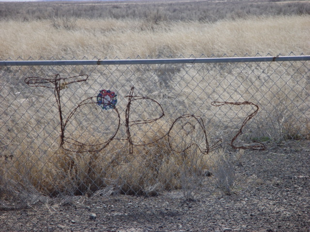
Japanese internment camp
 Topaz Internment Camp
The Topaz War Relocation Center is a World War II Japanese internment camp located in Millard County 15 miles (24 km) west of Delta. The location is open to the public with a memorial at the northwest corner.
Cities and towns
Note: Population has less than 100 permanent residents, but grows to 900 every summer months, due to seasonal migrant labor stays there (Hispanics are the main contributor) and forms the hub of the Mexican community of the Sevier Desert.[citation needed]
- Delta
- EskDale
- Fillmore
- Gandy
- Garrison
- Hinckley
- Holden
- Kanosh
- Leamington
- Lynndyl
- Meadow
- Oak City
- Oasis
- Scipio
See also
- Cove Fort, Utah
- National Register of Historic Places listings in Millard County, Utah
- USS Millard County (LST-987)
- Willden Fort
References
- ^ "Find a County". National Association of Counties. http://www.naco.org/Counties/Pages/FindACounty.aspx. Retrieved 2011-06-07.
- ^ "American FactFinder". United States Census Bureau. http://factfinder.census.gov. Retrieved 2008-01-31.
- ^ Millard County QuickFacts from the US Census Bureau
- ^ Jenson, Andrew (2004). Church Chronology. Kessinger Publishing. pp. 54. ISBN 1417968540. http://books.google.com/books?id=XEpUpEqDCfgC&pg=RA3-PA54&dq=Alonzo+A.+Hinckley#PRA3-PA54,M1.

Juab County Sanpete County White Pine County, Nevada 
Sevier County  Millard County, Utah

Lincoln County, Nevada Beaver County Municipalities and communities of Millard County, Utah Cities 
Towns CDP Unincorporated
communitiesGhost towns  State of Utah
Topics - Cities
- Congressional districts
- Counties
- Flag
- Geography
- Government
- Governors
- History
- People
- Portal
- Symbols
- Visitor Attractions
Society - Demographics
- Economy
- Politics
Regions Largest cities - American Fork
- Bountiful
- Cedar City
- Clearfield
- Cottonwood Heights
- Draper
- Holladay
- Kaysville
- Layton
- Lehi
- Logan
- Midvale
- Murray
- Ogden
- Orem
- Pleasant Grove
- Provo
- Riverton
- Roy
- St. George
- Salt Lake City
- Sandy
- South Jordan
- South Salt Lake
- Spanish Fork
- Springville
- Taylorsville
- Tooele
- West Jordan
- West Valley City
Counties Attractions Categories:- Utah counties
- Millard County, Utah
- 1852 establishments in the United States


Wikimedia Foundation. 2010.