- Utah State Route 201
Infobox road
state=UT
type=SR
route=201
section=126
maint=UDOT 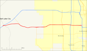
length_mi=16.699
length_round=3
length_ref=cite web | title=State Route 201 Highway reference | publisher=Utah Department of Transportation | url=http://www.udot.utah.gov/main/uconowner.gf?n=52577302541859415]
established=1939
direction_a=West
terminus_a=jct|state=UT|I|80 near Magna
junction=jct|state=UT|I|215 in West Valley City jct|state=UT|I|15|I|80 in Salt Lake City
direction_b=East
terminus_b=jct|state=UT|US|89 in Salt Lake City
previous_type=SR
previous_route=200
next_type=SR
next_route=202State Route 201 (SR-201), known locally as the 21st South Freeway (alluding to the placement of most of the freeway) or simply "the 201", is a freeway/expressway located in
Salt Lake County, Utah ,United States . It provides an alternative to Interstate 80 when needed and also is very important for the residents of the westside and Tooele County that work in Salt Lake City. The highway is an old routing of U.S. Route 50 and is signed as the routes of theLincoln Highway ,Pony Express and theCalifornia Trail .cite web
url=http://members.aol.com/utahhwys/rte201.htm
title=Utah Highways
author=Dan Stober
accessdate=2007-12-14]Route description
SR-201 forks from Interstate 80 where the freeway passes between the
Oquirrh Mountains and theGreat Salt Lake near the county line with Tooele County. The expressway passes by theKennecott Smokestack , [cite map |publisher=Google Maps |title=UT-201 near Kennecott Smokestack |url=http://maps.google.com/maps?f=q&hl=en&geocode=&q=kennecot&sll=40.710313,-112.198906&sspn=0.107741,0.253716&ie=UTF8&ll=40.724006,-112.20736&spn=0.006732,0.015857&t=h&z=16
cartography=NAVTEQ |accessdate=2008-08-06 ] the tallest structure in Utah, and is parallel to Kennecott's electric rail line until just west of 9200 West. [cite map|publisher=Benchmark Maps |title=Utah Road and Recreation Atlas |url=http://www.benchmark.com |year=2002 |scale=1:250000 |page=42 |section = G6 |isbn=0-929591-74-7] SR-201 is routed at approximately 2100 South in Salt Lake County's grid system, giving the freeway its nickname of "21st South Freeway". [cite news|url=http://web.ksl.com/dump/news/cc/i15facts.htm|title=Facts About I-15 Reconstruction|publisher=KSL-TV |accessdate=2008-08-06]The road is an expressway between Interstate 80 and 5600 West where the expressway turns into a freeway. The intersection with 5600 West, Bangerter Highway and 3200 West are
diamond interchange s, but the interchange with I-215 is a fullcloverleaf interchange and both exits at Redwood Road (SR-68) and 900 West aresingle-point urban interchange s. [cite map |publisher=Google Maps |title=UT-201 overview |url=http://maps.google.com/maps?q=magna,+ut&ie=UTF8&oe=utf-8&client=firefox-a&ll=40.724494,-111.970253&spn=0.053859,0.126858&z=13
cartography=NAVTEQ |accessdate=2008-08-06 ] The route is not continuous driving eastbound however, and drivers wishing to connect to 2100 South and the continuation of SR-201 must exit at 900 West. SR-201 continues along 2100 South until the intersection with U.S. Route 89 (State Street). The freeway portion ends at an intersection sometimes called the "Spaghetti Bowl", where SR-201, Interstate 15 and Interstate 80 merge. Before the construction of the Spaghetti Bowl, the freeway portion had a direct connection to 2100 South.cite map|publisher=Utah Department of Transportation |title=Official Highway Map, Utah Transportation Comission |year=1983 |scale=1 inch =17.4 miles |section = Inset:Salt Lake City and Vicinity]History
State Route 201 is one of the original highways through Salt Lake. It was used and is still signed as the routes of the
Pony Express andLincoln Highway . The highway is also signed as the route of theCalifornia Trail although this is a less common branch calledHastings Cutoff that became infamous because of theDonner Party .cite web
url = http://www.fhwa.dot.gov/infrastructure/back0104.htm
last = Longfellow
first = Rickie
accessdate = 2008-06-26
title = The Hastings Cutoff and Highway 80 Tragedy of the Donner Party
publisher = Federal Highway Administration]2100 South both east and west of State Street (SR-1, now US-89) became a state highway in the 1910s. [http://books.google.com/books?id=pZUAAAAAMAAJ Fourth Biennial Report, State Road Commission, 1915 and 1916] , p. 218] In 1919, when the state legislature redefined the state road system to include only a short list given in the law and any
federal aid projects, East 2100 South remained as part of theLincoln Highway , [cite UTSR law|year=1919|quote=(e) The Lincoln Highway from the Utah-Wyoming State line, via Echo Canyon, Echo, Coalville, Hoytsville and Parley's canyon to Salt Lake City; thence westwardly via Magna, Garfield, Tooele, Stockton, St. John, Clover, Johnson's Pass, Granite Mountain and Ibapah to the Utah-Nevada State line.] and became part of SR-4 and US-40 in the 1920s,Rand McNally [http://www.broermapsonline.org/members/NorthAmerica/UnitedStates/NorthernRockies/Utah/ Auto Road Atlas] , 1926] but West 2100 South (except west of Magna) was given back to the county until 1939. That year, the state legislature created State Route 201, running west from SR-1 to SR-4 (now SR-111) near Magna. [cite UTSR law|year=1939|quote=Route 201. From route 1 on State street of Salt Lake City at Twenty-first South street in a westerly direction on Twenty-first South street to route 4 north of Magna, Utah.] U.S. Route 50 Alternate would later be moved from SR-171 to SR-201 west of SR-1, but US-40 continued to use North Temple Street (then SR-67) west of SR-1, turning south indowntown Salt Lake City to reach East 2100 South.Fact|date=June 2008 In 1962, when SR-4 was renumbered SR-2 and moved to the proposed location of I-80, SR-201 was extended in both directions - west on former SR-4 to SR-2 at Lake Point Junction and east on former SR-4 to SR-2 at the mouth ofParley's Canyon . The portion east of State Street was removed from the state highway system in 1969;Utah Department of Transportation , [http://www.udot.utah.gov/main/f?p=100:pg:5285268476414239680:::1:T,V:1348, Highway Resolutions] : PDFlink|1= [http://www.udot.utah.gov/main/uconowner.gf?n=200609191552051 Route 201] |2=3.33 MB, updated November 2007, accessed May 2008] much of the road west of I-15 has been upgraded to afreeway .Major intersections
The entire route is in Salt Lake County.
References
External links
* [http://members.aol.com/utahhwys/rte201.htm Utah Highways Pages -- Route 201]

Wikimedia Foundation. 2010.