- Utah State Route 154
Infobox road
state=UT
type=SR
route=154
alternate_name=Bangerter Highway
section=121
maint=UDOT 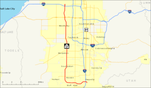
length_mi=24.319
length_round=3
length_ref=cite web | title=State Route 154 Highway reference | publisher=Utah Department of Transportation | url=http://www.dot.utah.gov/main/uconowner.gf?n=15534725385738550 ]
established=1989
direction_a=South
terminus_a=jct|state=UT|I|15 in Draper
junction=jct|state=UT|SR|201 in West Valley City
jct|state=UT|I|80 in Salt Lake City
direction_b=North
terminus_b=
previous_type=SR
previous_route=153
next_type=SR
next_route=155State Route 154, or Bangerter Highway—named after former
Utah GovernorNorman H. Bangerter —is an expressway running south from Draper through theSalt Lake Valley , eventually reaching theSalt Lake City International Airport . Construction began in1988 and portions of the highway were opened as completed, with the final section opening onNovember 17 ,1998 . It serves the rapidly-expanding population in the western and southern portions of Salt Lake Valley and facilitates access to and from the airport.Route description
From
Draper , SR-154 heads west until reaching Riverton, where it makes a turn for the north. It continues in this direction until reaching the airport, where it terminates. Access to Bangerter Highway is limited to major cross streets while it passes through Draper, Bluffdale, Riverton, South Jordan, West Jordan, Taylorsville, West Valley City, and Salt Lake City.History
Planning for the West Valley Highway began in the 1960s
Deseret News , W.V. Highway Now a Reality After Traveling a Rocky Road,November 27 ,1991 ] as a localfederal-aid project. The proposed alignment began at the curve in SR-68 near 15300 South and proceeded north-northwesterly and northerly, following a path much like the present alignment to I-80. It continued north along what was then the west boundary of theSalt Lake City Municipal Airport No. 1 into 4000 West, curving east onto 2200 North and ending at I-215. A drainage canal was moved to make room for a loop from 2200 North onto northbound I-215,Utah Department of Transportation , [http://www.udot.utah.gov/main/f?p=100:pg:5285268476414239680:::1:T,V:1348, Highway Resolutions] : PDFlink|1= [http://www.udot.utah.gov/main/uconowner.gf?n=200609191605231 Route 215] |2=9.62 MB, updated November 2007, accessed May 2008, pp. 9, 11, 14] but when the Interstate was finished south of 2200 North (where it had ended for many years) in the mid-1980s, [Federal Highway Administration ,National Bridge Inventory database, 2006] adiamond interchange was built instead.Fact|date=June 2008 Later the north segment was rerouted to continue north-northeasterly from the airport into Davis County;Utah Department of Transportation , [http://www.udot.utah.gov/main/f?p=100:pg:5285268476414239680:::1:T,V:1348, Highway Resolutions] : PDFlink|1= [http://www.udot.utah.gov/main/uconowner.gf?n=200609190944441 Route 172] |2=838 KB, updated November 2007, accessed May 2008, p. 5] parts of this are now being built as theLegacy Parkway . Salt Lake County was able to build the highway between SR-201 (2100 South) and I-80 with federal funding, but it took the state to finish it.In 1989, the
Utah Transportation Commission added a portion of the proposed West Valley Highway to the state highway system as State Route 154. A newly-proposed corridor ran west from I-15 near 13400 South to near 3200 West, where it joined the older proposal and headed north to I-80.Utah Department of Transportation , [http://www.udot.utah.gov/main/f?p=100:pg:5285268476414239680:::1:T,V:1348, Highway Resolutions] : PDFlink|1= [http://www.udot.utah.gov/main/uconowner.gf?n=200609190921411 Route 154] |2=2.18 MB, updated November 2007, accessed May 2008, p. 14] With the help of GovernorNorman H. Bangerter , longtime resident of West Valley City, the project received needed money from the state's general fund, and was opened between SR-201 (2100 South) and SR-171 (3500 South) onNovember 26 ,1991 . The Transportation Commission renamed the highway after Bangerter in May 1993. It was finally completed to I-15 onNovember 17 ,1998 .John Keahey,Salt Lake Tribune , Bangerter's Last Section Opens Today; Multilane highway extends from S.L. airport to Draper,November 17 ,1998 , p. B1]In 2007, a
continuous flow intersection was constructed at the junction of SR-154 and SR-171 (3500 South), one of a very few such intersections in theUnited States . The intersection is one of the busiest in the state and handles 100,000 vehicles on a typical weekday.cite web
publisher=KSL-TV
title=Continuous Flow Intersection to be Built on Bangerter Hwy
url=http://www.ksl.com/?nid=148&sid=963706
accessdate=13 April
accessmonth=
accessyear=2008]Major intersections
The entire route is in Salt Lake County.
References

Wikimedia Foundation. 2010.