- Siskiyou County, California
-
County of Siskiyou — County — Mount Shasta presides over much of Siskiyou County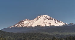

SealLocation in the state of California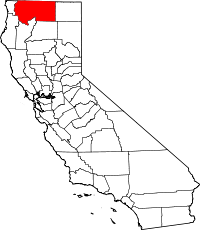 California's location in the United States
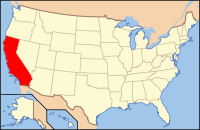
Coordinates: 41°35′N 122°30′W / 41.583°N 122.5°WCoordinates: 41°35′N 122°30′W / 41.583°N 122.5°W Country  United States
State  California
Region Shasta Cascade Incorporated 1852 County seat Yreka Area – Total 16,438.7 km2 (6,347 sq mi) – Land 16,283.3 km2 (6,287 sq mi) – Water 155.4 km2 (60 sq mi) Population (2010) – Total 44,900 – Density 2.7/km2 (7.1/sq mi) Time zone Pacific Standard Time (UTC-8) – Summer (DST) Pacific Daylight Time (UTC-7) Website www.co.siskiyou.ca.us Siskiyou County
 /ˈsɪskjuː/ siss-kew is a county located in the far northernmost part of the U.S. state of California, in the Shasta Cascade region on the Oregon border. Yreka is the county seat. Because of its substantial natural beauty, outdoor recreation opportunities, and Gold Rush era history, it is an important tourist destination within the state. The population was 44,900 at the 2010 census.
Contents
History
Siskiyou County was created on March 22, 1852, from parts of Shasta and Klamath Counties, and named after the Siskiyou mountain range. Parts of the county's territory were given to Modoc County in 1855.
The county is the site of the central section of the Siskiyou Trail, which ran between California's Central Valley and the Pacific Northwest. The Siskiyou Trail was based on Native American footpaths, was expanded by Hudson's Bay Company trappers in the 1830s, and was expanded still further by "Forty-Niners" during the California Gold Rush.
In 1851, after the discovery of an important gold strike near today’s Yreka, California, thousands of prospectors flooded the area. This era and setting was described in detail in the semi-autobiographical novel, Life Amongst the Modocs, written by poet and novelist Joaquin Miller.
The construction of the Central Pacific Railroad along the path of the Siskiyou Trail in the mid-1880s led to a first wave of tourism, as visitors came to “take the waters” at the county’s many summer resorts, and to enjoy the hunting, fishing and other outdoor recreation activities. The Southern Pacific railroad (successor to the Central Pacific) promoted the scenic beauty of the area by calling its rail line through the area “The Road of A Thousand Wonders.”
In the early 1940s, Siskiyou County was home to the semi-serious State of Jefferson movement, which sought to create a new state from several counties of northern California, and several counties of southern Oregon.
The origin of the word siskiyou is not known. One version is that it is the Chinook Jargon word for "bob-tailed horse." Another version, given in an argument before the State Senate in 1852, is that the French name Six Cailloux, meaning "six stones," was given to a ford on the Umpqua River by Michel LaFrambois and a party of Hudson's Bay Company trappers in 1832, because six large stones or rocks lay in the river where they crossed. According to some, the Six Cailloux name was appropriated to this region by Stephen Meek, another Hudson's Bay Company trapper who was known for his "discovery" of Scott Valley, in regard to a crossing on the Klamath River near Hornbrook.
The County is also home to the Black Bear Ranch, a commune started in 1968 with the slogan "Free Land for free people." The commune is still around today.
Geography
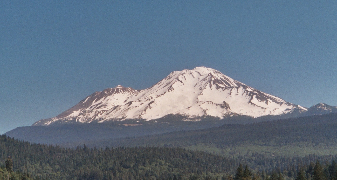
Siskiyou County is geographically diverse. From towering Mount Shasta (elev. 14,179 ft/(4,322 m)) near the center of the county, to lakes and dense forests, as well as desert, chaparral, and memorable waterfalls, the county is home to world-famous trout-fishing rivers and streams, such as the Sacramento and McCloud Rivers. The county is dotted as well with lakes and reservoirs,[1] such as Castle Lake and Lake Siskiyou. Mount Shasta itself has a winter sports center. Pastoral Scott Valley in the western part of the county has many wide, tree-lined meadows, supporting large cattle ranches. The basins of northeastern Siskiyou County, including Butte Valley, Lower Klamath and Tule Lake basins, have some of the deepest and richest soils in the state, producing alfalfa, potatoes, horseradish, and brewing barley. Butte Valley nurseries are the leading source of premium strawberry plants in North America. Much of the county is densely forested with pine, fir, incense-cedar, oak, and madrone; Siskiyou County is also home to the rare Baker's Cypress Tree, Cupressus bakeri, which grows in only eleven scattered locations in the world, five of which are in Siskiyou County. The county's natural resources are most often used these days for skiing, snowboarding, hiking, mountain biking, camping, and wilderness recreation, as historic logging practices have been largely discontinued due to Federal and State environmental regulations. The county’s water is viewed as sufficiently pure and abundant that the county is a source of significant amounts of bottled water, distributed throughout the country. A large Crystal Geyser plant is located at the base of Mt. Shasta, near Weed.
While it ranks fifth in area among California counties (and is larger than three U.S. states), with some 6,347 square miles (16,440 km2),[2] it only ranked 44th in population among California’s 58 counties; as of 2000, the population was 44,301.
Cities over 5,000 population
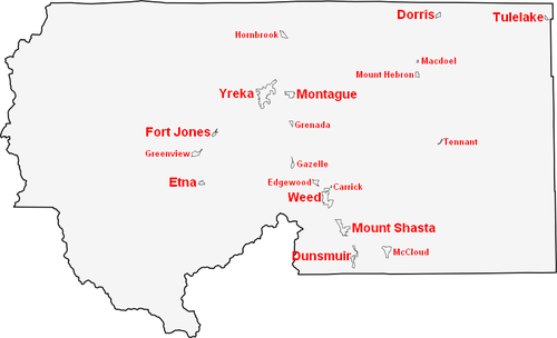

Cities over 1,000 population
Cities under 1,000 population
Unincorporated towns and CDPs
- Big Springs
- Callahan
- Carrick
- Clear Creek
- Edgewood
- Forks of Salmon
- Fort Goff
- Gazelle
- Greenview
- Grenada
- Hamburg
- Hatfield
- Happy Camp
- Hilt
- Hornbrook
- Horse Creek
- Klamath River
- Klamathon
- Lake Shastina
- Lake Siskiyou
- Macdoel
- McCloud
- Mount Hebron
- Mugginsville
- Sawyers Bar
- Seiad Valley
- Tennant
- Thompson Creek
Adjacent Counties
- Del Norte County, California - west
- Humboldt County, California - southwest
- Trinity County, California - south
- Shasta County, California - south
- Modoc County, California - east
- Klamath County, Oregon - north
- Jackson County, Oregon - north
- Josephine County, Oregon - northwest
See also: List of counties bordering eight or more countiesNational protected areas
- Butte Valley National Grassland
- Klamath National Forest (part)
- Lava Beds National Monument (part)
- Lower Klamath National Wildlife Refuge (part)
- Modoc National Forest (part)
- Rogue River National Forest (part)
- Shasta National Forest (part)
- Six Rivers National Forest (part)
- Tule Lake National Wildlife Refuge (part)
Transportation Infrastructure
Major Highways
Public Transportation
Siskiyou Transit And General Express (STAGE) operates buses connecting the more populated areas of the county. Amtrak trains stop in Dunsmuir. Amtrak California motorcoaches operate from Sacramento and Medford, OR, with stops in Yreka, Weed, Mount Shasta, and Dunsmuir, for passengers connecting to and from Amtrak trains in Sacramento or Stockton.
Airports
Siskiyou County owns and operates Butte Valley Airport, Happy Camp Airport, Scott Valley Airport, Siskiyou County Airport and Weed Airport (all general aviation). Dunsmuir Municipal-Mott Airport and Montague-Yreka Rohrer Field are also located within the county.
The closest airports where commercial domestic planes depart from is Rogue Valley International-Medford Airport north of the county in Medford, Oregon, Klamath Falls International Airport, northeast of the county in Klamath Falls, Oregon,and Redding Municipal Airport south of the county in Redding, California.
Politics
Siskiyou County vote
by party in presidential electionsYear GOP DEM Others 2008 53.7% 11,520 43.3% 9,292 3.5% 752 2004 60.6% 12,673 37.7% 7,880 1.7% 346 2000 61.6% 12,198 31.9% 6,323 6.6% 1,298 1996 47.3% 8,653 38.4% 7,022 14.3% 2,618 1992 32.2% 6,660 39.9% 8,254 27.9% 5,765 1988 50.9% 9,056 47.0% 8,365 2.1% 376 1984 58.3% 10,544 39.4% 7,130 2.4% 427 1980 55.8% 9,331 33.8% 5,664 10.4% 1,743 1976 48.4% 7,070 48.3% 7,060 3.3% 485 1972 51.5% 7,563 43.8% 6,434 4.8% 699 1968 46.1% 6,334 45.6% 6,260 8.3% 1,138 1964 36.2% 5,186 63.7% 9,126 0.2% 23 1960 43.0% 6,279 56.4% 8,245 0.7% 96 1956 49.8% 6,841 49.8% 6,837 0.5% 63 1952 55.7% 8,735 43.4% 6,800 1.0% 151 1948 42.5% 5,315 54.0% 6,749 3.5% 434 1944 42.2% 4,351 57.3% 5,914 0.6% 58 1940 35.9% 4,387 63.2% 7,714 0.9% 111 1936 29.5% 2,919 69.3% 6,865 1.3% 125 1932 26.8% 2,458 69.3% 6,367 3.9% 359 1928 55.5% 3,758 43.1% 2,916 1.5% 98 1924 40.6% 2,437 9.7% 584 49.7% 2,984 1920 60.1% 2,909 31.0% 1,502 8.9% 433 Siskiyou is a strongly Republican county in Presidential and congressional elections. The last Democrat to win a plurality in the county was Bill Clinton in 1992. Siskiyou is part of California's 2nd congressional district, which is held by Republican Wally Herger. In the state legislature Siskiyou is in the 2nd Assembly district, which is held by Republican Jim Nielsen, and the 4th Senate district, which is held by Republican Doug LaMalfa.
On Nov. 4, 2008 Siskiyou County voted 60.1 % for Proposition 8 which amended the California Constitution to ban same-sex marriages.
Demographics
2010
The 2010 United States Census reported that Siskiyou County had a population of 44,900. The racial makeup of Siskiyou County was 38,030 (84.7%) White, 571 (1.3%) African American, 1,814 (4.0%) Native American, 540 (1.2%) Asian, 80 (0.2%) Pacific Islander, 1,491 (3.3%) from other races, and 2,374 (5.3%) from two or more races. Hispanic or Latino of any race were 4,615 persons (10.3%).[3]
Population reported at 2010 United States Census The County Total
PopulationWhite African
AmericanNative
AmericanAsian Pacific
Islanderother
racestwo or
more racesHispanic
or Latino
(of any race)Siskiyou County 44,900 38,030 571 1,814 540 80 1,491 2,374 4,615 Incorporated
cities and townsTotal
PopulationWhite African
AmericanNative
AmericanAsian Pacific
Islanderother
racestwo or
more racesHispanic
or Latino
(of any race)Dorris 939 764 19 18 5 8 77 48 197 Dunsmuir 1,650 1,443 32 17 15 4 30 109 167 Etna 737 627 0 28 1 1 6 74 26 Fort Jones 839 650 33 61 8 0 23 64 103 Montague 1,443 1,251 4 67 8 1 17 95 107 Mount Shasta 3,394 3,041 61 19 56 2 51 164 277 Tulelake 1,010 563 1 15 1 0 365 65 601 Weed 2,967 2,221 206 70 121 27 132 190 475 Yreka 7,765 6,495 57 491 94 9 168 451 753 Census-designated
placesTotal
PopulationWhite African
AmericanNative
AmericanAsian Pacific
Islanderother
racestwo or
more racesHispanic
or Latino
(of any race)Carrick 131 110 7 2 2 0 1 9 8 Edgewood 43 41 0 0 0 0 1 1 2 Gazelle 70 65 0 4 0 0 1 0 5 Greenview 201 161 0 10 1 0 8 21 19 Grenada 367 307 2 35 1 0 3 19 12 Happy Camp 1,190 814 2 277 7 1 18 71 95 Hornbrook 248 195 0 15 0 0 10 28 19 Macdoel 133 57 0 6 0 0 69 1 78 McCloud 1,101 1,039 8 10 6 0 5 33 65 Mount Hebron 95 73 0 1 0 0 18 3 41 Tennant 41 36 0 2 0 0 1 2 4 Unincorporated
communitiesTotal
PopulationWhite African
AmericanNative
AmericanAsian Pacific
Islanderother
racestwo or
more racesHispanic
or Latino
(of any race)All others not CDPs (combined) 20,536 18,077 139 666 214 27 487 926 1,561 2000
As of the census[4] of 2000, there were 44,301 people, 18,556 households, and 12,228 families residing in the county. The population density was 7/sq mi (3/km2). There were 21,947 housing units at an average density of 4/sq mi (1/km2). The racial makeup of the county was 87.07% White, 1.31% Black or African American, 3.90% Native American, 1.19% Asian, 0.13% Pacific Islander, 2.76% from other races, and 3.65% from two or more races. 7.57% of the population were Hispanic or Latino of any race. 13.5% were of German, 12.0% English, 9.8% Irish, 9.5% American and 7.1% Italian ancestry according to Census 2000. 91.7% spoke English and 5.7% Spanish as their first language.
There were 18,556 households out of which 27.6% had children under the age of 18 living with them, 51.7% were married couples living together, 10.1% had a female householder with no husband present, and 34.1% were non-families. 28.6% of all households were made up of individuals and 12.8% had someone living alone who was 65 years of age or older. The average household size was 2.35 and the average family size was 2.87.
In the county the population was spread out with 24.0% under the age of 18, 6.7% from 18 to 24, 22.7% from 25 to 44, 28.4% from 45 to 64, and 18.1% who were 65 years of age or older. The median age was 43 years. For every 100 females there were 96.5 males. For every 100 females age 18 and over, there were 94.1 males.
The median income for a household in the county was $29,530, and the median income for a family was $36,890. Males had a median income of $31,936 versus $22,650 for females. The per capita income for the county was $17,570. About 14.0% of families and 18.6% of the population were below the poverty line, including 26.6% of those under age 18 and 7.3% of those age 65 or over.
Flora and fauna
Substantial amounts of the county are forested within the Siskiyou and Cascade Ranges, including significant oak woodland and mixed conifer forests. Siskiyou County is the northern extent of the range for California Buckeye,[5] a widespread California endemic. The Klamath National Forest occupies 1,700,000 acres (6,900 km2) of land which includes elements in Siskiyou County as well as Jackson County, Oregon.[6]
See also
- Hiking trails in Siskiyou County
- List of school districts in Siskiyou County, California
- National Register of Historic Places listings in Siskiyou County, California
- Upper Soda Springs
- Shasta Springs
- Yreka Western Railroad
Notes
- ^ List of Siskiyou County lakes
- ^ http://www.dof.ca.gov/HTML/FS_DATA/stat-abs/tables/a1.xls
- ^ "2010 Census P.L. 94-171 Summary File Data". United States Census Bureau. http://www2.census.gov/census_2010/01-Redistricting_File--PL_94-171/California/.
- ^ "American FactFinder". United States Census Bureau. http://factfinder.census.gov. Retrieved 2008-01-31.
- ^ C.Michael Hogan (2008) Aesculus californica, Globaltwitcher.com, ed. N. Stromberg
- ^ Siskiyou County factsheet
External links
- County of Siskiyou Official Website
- Museum of the Siskiyou Trail
- Siskiyou County Visitors Bureau
- Portal to Mount Shasta Area

Josephine County, Oregon Jackson County, Oregon and Klamath County, Oregon Del Norte County 
Modoc County  Siskiyou County, California

Humboldt County Trinity County and Shasta County Municipalities and communities of Siskiyou County, California Cities Dorris | Dunsmuir | Etna | Fort Jones | Montague | Mount Shasta | Tulelake | Weed | Yreka
CDPs Unincorporated
communitiesBlack Butte | Callahan | Cecilville | Forks of Salmon | Klamath River | Horse Creek | Pondosa | Sawyers Bar | Scott Bar | Seiad Valley | Somes Bar
Indian reservation Categories:- California counties
- Siskiyou County, California
- California Gold Rush
- Chinook Jargon placenames


Wikimedia Foundation. 2010.