- California State Route 3
Infobox road
state=CA
type=SR
route=3
section=303
maint=Caltrans 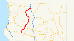
length_mi=148.81
length_round=2
length_ref=California Department of Transportation , [http://www.dot.ca.gov/hq/structur/strmaint/brlog2.htm Log of Bridges on State Highways] , July 2007]
established=1964 renumbering [http://cahighways.org/001-008.html#003 California Highways: State Route 3] ]
direction_a=South
terminus_a=jct|state=CA|SR|36 near Peanut
junction=jct|state=CA|SR|299 at Weaverville
jct|state=CA|I|5 in Yreka
direction_b=North
terminus_b=Ball Mountain Little Shasta Road in Montague
previous_type=SR
previous_route=2
next_type=SR
next_route=4State Route 3 is a convert|148.81|mi|km|adj=on long
state highway in the northern region of theU.S. state ofCalifornia . It runs from SR-36 north along the shore ofTrinity Lake , Fort Jones and Etna. The route approaches Yreka, intersecting with Interstate 5, and turns east to Montague. The road was numbered SR 3 in 1964, and most of it has been part of the state highway system since 1933.This route is part of the
California Freeway and Expressway System [http://www.leginfo.ca.gov/cgi-bin/displaycode?section=shc&group=00001-01000&file=250-257 CA Codes (shc:250-257)] ] and is eligible for the State Scenic Highway System. [http://www.leginfo.ca.gov/cgi-bin/displaycode?section=shc&group=00001-01000&file=260-284 CA Codes (shc:260-284)] ]Route description
State Route 3 begins at the junction with State Route 36 south of the town of Peanut in Trinity County. SR-3 is also known as Bramlot Road from its southern terminus to Hayfork. This stretch of road through the
Shasta-Trinity National Forest parallels theHayfork River . Once SR-3 reaches the town of Hayfork, it travels along Hyampom Road east and snakes through the mountains to Douglas City and the junction with State Route 299. From there, SR 3 runs concurrently with SR 299 north to the town of Weaverville.Cite map | publisher=Rand McNally | title=The Road Atlas | year=2008 | page=12 | section=NB3-NE4 ] Cite map | publisher=Thomas Brothers | title=California Road Atlas and Driver's Guide | year=2000 | page=3,4,11,12,17] SR 3 then departs from SR 299, providing access to theWhiskeytown-Shasta-Trinity National Recreation Area andTrinity Dam alongLewiston Lake . SR 3 passes through the towns of Covington Mill, Trinity Center, and Wyntoon before paralleling theTrinity River as Weaverville-Scott Mountain Road and crossing theScott Mountains and thePacific Crest Trail at convert|5205|ft|m into Siskiyou County.cite web |url=http://www.cahighways.org/001-008.html|title=California Highways (www.cahighways.org): Routes 1 through 8 |accessdate=2007-12-08 |author=Daniel P. Faigin.]In Siskiyou County, SR 3 passes through Callahan, Etna, Greenview, and Fort Jones as it turns northeast to intersect with Interstate 5 in Yreka. At this point, State Route 263 continues in the northerly direction towards State Route 96; SR 3 turns east to its northern terminus in the incorporated city of Montague.
History
The short piece from SR 36 north to Peanut was added to the state highway system in 1907 as part of the
Peanut Road , [cite CAstat|year=1907|ch=117|p=139] which became Route 35 in 1917. [Ben Blow, California Highways: A Descriptive Record of Road Development by the State and by Such Counties as Have Paved Highways, 1920 ( [http://www.archive.org/details/californiahighwa00blowrich Archive.org] or [http://books.google.com/books?id=osgNAAAAYAAJ Google Books] ), p. 112] Route 35 was extended north from Peanut to Route 20 (SR 299) near Douglas City in 1933, and simultaneously a new Route 82 was created, running from Route 3 (I-5) in the Yreka area southwest to Etna and east to Montague. [cite CAstat|year=1933|ch=767|p=2034: "Etna Mills to Montague." "State Highway Route 35 near Peanut to State Highway Route 20 near Douglas City."] [cite CAstat|year=1935|ch=29|p=277, 281: "Route 35 is from Route 1 near Alton to Route 20 near Douglas City, passing near Kuntz and Peanut." "Route 82 is from Etna Mills to Montague."] The gap between Douglas City and Etna was filled in 1959 with an extension of Route 82 south to Route 20 near Weaverville; at the same time, the portion between Weaverville and Yreka was added to theCalifornia Freeway and Expressway System , which identifies the main routes of transportation in the state of California. [cite CAstat|year=1959|ch=1062|p=3113, 3116] The State Route 3 designation was applied to the Peanut-Montague roadway in the 1964 renumbering. [cite CAstat|year=1963|ch=385|p=1171] The overlap with temporary I-5 (along the portion where SR 3 runs concurrently with Interstate 5 today) near Yreka was removed when the new I-5 bypass was built; the legislative definition was updated to reflect this in 1974, soon after the building of the bypass. [cite CAstat|year=1974|ch=123|p=247: "Route 3 is from: ...(b) Route 299 near Weaverville to Montague via Main Street in Yreka."]Major intersections
:"Note: Except where prefixed with a letter,
postmile s were measured in 1964, based on the alignment as it existed at that time, and do not necessarily reflect current mileage. The numbers reset at county lines; the start and end postmiles in each county are given in the county column."References
External links
* [http://www.westcoastroads.com/california/ca-003.html WestCoast Roads- State Route 3]
* [http://www.dot.ca.gov/hq/roadinfo/sr3 Caltrans: Route 3 highway conditions]
* [http://www.cahighways.org/001-008.html#003 California Highways: SR 3]
* [http://www.geocities.com/bennyp81/ca3.html The Big Highways Page: California Route 3]

Wikimedia Foundation. 2010.