- California State Route 299
Infobox road
state=CA
type=SR
route=299
section=599
maint=Caltrans 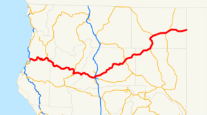
length_mi=305.777
length_round=0
length_ref=
direction_a=West
terminus_a=Jct|state=CA|US|101 in Arcata
junction=Jct|state=CA|SR|3 at Weaverville
Jct|state=CA|I|5 in Redding
Jct|state=CA|US|395 in Alturas
direction_b=East
terminus_b=jct|state=NV|SR|8A towardsVya, NV
previous_type=SR
previous_route=284
next_type=SR
next_route=330State Route 299 is a
state highway in theU.S. state ofCalifornia that runs across the northern part of the state. It runs from Arcata on thePacific Ocean to the border withNevada . Between Arcata and Redding, Route 299 junctions with State Route 96 and is briefly co-signed with State Route 3. In Redding, it intersects with State Route 273 and State Route 44 and a short section is co-signed with Interstate 5. East of Redding, it intersects with State Route 89 and a section is co-signed with State Route 139 before reaching Alturas. It is then co-signed with U.S. Route 395 north-east of Alturas, then it runs east towards the border with Nevada. A ghost town,Vya, Nevada , can be reached via this route, which after the border becomes a dirt road, which was formerlyNevada State Route 8A .Part of SR 299 is the Trinity Scenic Byway, a
Forest Service Byway .This route is part of the
California Freeway and Expressway System [http://www.leginfo.ca.gov/cgi-bin/displaycode?section=shc&group=00001-01000&file=250-257 CA Codes (shc:250-257)] ] and is eligible for the State Scenic Highway System [http://www.leginfo.ca.gov/cgi-bin/displaycode?section=shc&group=00001-01000&file=260-284 CA Codes (shc:260-284)] ] .Route description
History
State Route 299, from the intersection with US 101 all the way to US 395 in Alturas, was U.S. Route 299 from 1934 to 1964, but the actual road has been realigned many times, mainly to make easier grades and curves through the mountains. In many places, especially in Trinity County, the old concrete can be seen beside the new road, and there is even an arch bridge from 1923 visible from the current 299, that seemingly connects nothing to nothing nowadays.
Major intersections and exit list
:"Note: Except where prefixed with a letter,
postmile s were measured in 1964, based on the alignment as it existed at that time, and do not necessarily reflect current mileage. The numbers reset at county lines; the start and end postmiles in each county are given in the county column."ources
* [http://www.nevadadot.com/traveler/maps/statemaps/ NevadaDOT state maps]
References

Wikimedia Foundation. 2010.