- Montague, California
-
City of Montague — City — Location in Siskiyou County and the state of California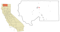
Coordinates: 41°43′38″N 122°31′35″W / 41.72722°N 122.52639°WCoordinates: 41°43′38″N 122°31′35″W / 41.72722°N 122.52639°W Country  United States
State  California
County Siskiyou Area[1] – Total 1.793 sq mi (4.644 km2) – Land 1.778 sq mi (4.605 km2) – Water 0.015 sq mi (0.039 km2) 0.85% Elevation 2,539 ft (774 m) Population (2010) – Total 1,443 – Density 804.8/sq mi (310.7/km2) Time zone Pacific (PST) (UTC-8) – Summer (DST) PDT (UTC-7) ZIP code 96064 Area code(s) 530 FIPS code 06-48690 GNIS feature ID 0277557 Montague is a city in Siskiyou County, California, United States. The population was 1,443 at the 2010 census, down from 1,456 at the 2000 census.
Contents
Geography
Montague is located at 41°43′38″N 122°31′35″W / 41.72722°N 122.52639°W (41.727168, -122.526468)[2].
According to the United States Census Bureau, the city has a total area of 1.8 square miles (4.6 km²), 99.15% of it land and 0.85% of it water.
Demographics
2010
The 2010 United States Census[3] reported that Montague had a population of 1,443. The population density was 804.8 people per square mile (310.7/km²). The racial makeup of Montague was 1,251 (86.7%) White, 4 (0.3%) African American, 67 (4.6%) Native American, 8 (0.6%) Asian, 1 (0.1%) Pacific Islander, 17 (1.2%) from other races, and 95 (6.6%) from two or more races. Hispanic or Latino of any race were 107 persons (7.4%).
The Census reported that 1,425 people (98.8% of the population) lived in households, 18 (1.2%) lived in non-institutionalized group quarters, and 0 (0%) were institutionalized.
There were 576 households, out of which 198 (34.4%) had children under the age of 18 living in them, 255 (44.3%) were opposite-sex married couples living together, 86 (14.9%) had a female householder with no husband present, 31 (5.4%) had a male householder with no wife present. There were 64 (11.1%) unmarried opposite-sex partnerships, and 1 (0.2%) same-sex married couples or partnerships. 159 households (27.6%) were made up of individuals and 49 (8.5%) had someone living alone who was 65 years of age or older. The average household size was 2.47. There were 372 families (64.6% of all households); the average family size was 2.95.
The population was spread out with 368 people (25.5%) under the age of 18, 119 people (8.2%) aged 18 to 24, 382 people (26.5%) aged 25 to 44, 390 people (27.0%) aged 45 to 64, and 184 people (12.8%) who were 65 years of age or older. The median age was 37.9 years. For every 100 females there were 95.3 males. For every 100 females age 18 and over, there were 96.2 males.
There were 633 housing units at an average density of 353.0 per square mile (136.3/km²), of which 371 (64.4%) were owner-occupied, and 205 (35.6%) were occupied by renters. The homeowner vacancy rate was 2.4%; the rental vacancy rate was 10.4%. 886 people (61.4% of the population) lived in owner-occupied housing units and 539 people (37.4%) lived in rental housing units.
2000
As of the census[4] of 2000, there were 1,456 people, 560 households, and 390 families residing in the city. The population density was 815.3 people per square mile (314.1/km²). There were 609 housing units at an average density of 341.0 per square mile (131.4/km²). The racial makeup of the city was 89.01% White, 0.07% African American, 5.08% Native American, 0.14% Asian, 0.07% Pacific Islander, 2.20% from other races, and 3.43% from two or more races. Hispanic or Latino of any race were 5.43% of the population.
There were 560 households out of which 36.3% had children under the age of 18 living with them, 50.4% were married couples living together, 14.5% had a female householder with no husband present, and 30.2% were non-families. 25.4% of all households were made up of individuals and 12.0% had someone living alone who was 65 years of age or older. The average household size was 2.57 and the average family size was 3.07.
In the city the population was spread out with 28.7% under the age of 18, 8.1% from 18 to 24, 27.0% from 25 to 44, 24.0% from 45 to 64, and 12.2% who were 65 years of age or older. The median age was 36 years. For every 100 females there were 97.0 males. For every 100 females age 18 and over, there were 91.5 males.
The median income for a household in the city was $22,991, and the median income for a family was $28,672. Males had a median income of $30,455 versus $22,250 for females. The per capita income for the city was $12,661. About 19.6% of families and 24.2% of the population were below the poverty line, including 34.0% of those under age 18 and 10.8% of those age 65 or over.
Politics
In the state legislature Montague is located in the 4th Senate District, represented by Republican Doug LaMalfa, and in the 2nd Assembly District, represented by Republican Jim Nielsen. Federally, Montague is located in California's 2nd congressional district, which has a Cook PVI of R +13[5] and is represented by Republican Wally Herger.
References
- ^ U.S. Census
- ^ "US Gazetteer files: 2010, 2000, and 1990". United States Census Bureau. 2011-02-12. http://www.census.gov/geo/www/gazetteer/gazette.html. Retrieved 2011-04-23.
- ^ All data are derived from the United States Census Bureau reports from the 2010 United States Census, and are accessible on-line here. The data on unmarried partnerships and same-sex married couples are from the Census report DEC_10_SF1_PCT15. All other housing and population data are from Census report DEC_10_DP_DPDP1. Both reports are viewable online or downloadable in a zip file containing a comma-delimited data file. The area data, from which densities are calculated, are available on-line here. Percentage totals may not add to 100% due to rounding. The Census Bureau defines families as a household containing one or more people related to the householder by birth, opposite-sex marriage, or adoption. People living in group quarters are tabulated by the Census Bureau as neither owners nor renters. For further details, see the text files accompanying the data files containing the Census reports mentioned above.
- ^ "American FactFinder". United States Census Bureau. http://factfinder.census.gov. Retrieved 2008-01-31.
- ^ "Will Gerrymandered Districts Stem the Wave of Voter Unrest?". Campaign Legal Center Blog. http://www.clcblog.org/blog_item-85.html. Retrieved 2007-10-20.
Municipalities and communities of Siskiyou County, California Cities Dorris | Dunsmuir | Etna | Fort Jones | Montague | Mount Shasta | Tulelake | Weed | Yreka
CDPs Unincorporated
communitiesBlack Butte | Callahan | Cecilville | Forks of Salmon | Klamath River | Horse Creek | Pondosa | Sawyers Bar | Scott Bar | Seiad Valley | Somes Bar
Indian reservation Categories:- Incorporated cities and towns in California
- Cities in Siskiyou County, California


Wikimedia Foundation. 2010.