- Dorris, California
-
City of Dorris — City — Location in Siskiyou County and the state of California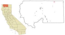
Coordinates: 41°57′54″N 121°55′8″W / 41.965°N 121.91889°WCoordinates: 41°57′54″N 121°55′8″W / 41.965°N 121.91889°W Country  United States
State  California
County Siskiyou Area[1] – Total 0.718 sq mi (1.860 km2) – Land 0.702 sq mi (1.819 km2) – Water 0.016 sq mi (0.041 km2) 2.19% Elevation[2] 4,245 ft (1,294 m) Population (2010) – Total 939 – Density 1,307.8/sq mi (504.8/km2) Time zone Pacific (PST) (UTC-8) – Summer (DST) PDT (UTC-7) ZIP code 96023 Area code(s) 530 FIPS code 06-19584 GNIS feature ID 277500 Website http://www.buttevalleychamber.com/cityofdorris/ Dorris is a city in Siskiyou County, California, United States. The population was 939 at the 2010 census, up from 886 at the 2000 census.
Contents
Geography
Dorris is located at 41°57′54″N 121°55′8″W / 41.965°N 121.91889°W (41.965075, -121.918967).[3] Dorris is located in the Butte Valley of Northern California between Mt. Shasta and the Oregon Border on Hwy 97. It is home to what was once the country's tallest flagpole west of the Mississippi. In 2002, a larger pole was erected in Laredo, TX.[4]
According to the United States Census Bureau, the city has a total area of 0.7 square miles (1.8 km2), 97.81% of it land and 2.19% of it water.
Demographics
2010
The 2010 United States Census[5] reported that Dorris had a population of 939. The population density was 1,307.5 people per square mile (504.8/km²). The racial makeup of Dorris was 764 (81.4%) White, 19 (2.0%) African American, 18 (1.9%) Native American, 5 (0.5%) Asian, 8 (0.9%) Pacific Islander, 77 (8.2%) from other races, and 48 (5.1%) from two or more races. Hispanic or Latino of any race were 197 persons (21.0%).
The Census reported that 939 people (100% of the population) lived in households, 0 (0%) lived in non-institutionalized group quarters, and 0 (0%) were institutionalized.
There were 364 households, out of which 125 (34.3%) had children under the age of 18 living in them, 171 (47.0%) were opposite-sex married couples living together, 47 (12.9%) had a female householder with no husband present, 23 (6.3%) had a male householder with no wife present. There were 33 (9.1%) unmarried opposite-sex partnerships, and 1 (0.3%) same-sex married couples or partnerships. 106 households (29.1%) were made up of individuals and 44 (12.1%) had someone living alone who was 65 years of age or older. The average household size was 2.58. There were 241 families (66.2% of all households); the average family size was 3.15.
The population was spread out with 240 people (25.6%) under the age of 18, 91 people (9.7%) aged 18 to 24, 216 people (23.0%) aged 25 to 44, 256 people (27.3%) aged 45 to 64, and 136 people (14.5%) who were 65 years of age or older. The median age was 38.2 years. For every 100 females there were 102.4 males. For every 100 females age 18 and over, there were 94.2 males.
There were 414 housing units at an average density of 576.5 per square mile (222.6/km²), of which 248 (68.1%) were owner-occupied, and 116 (31.9%) were occupied by renters. The homeowner vacancy rate was 3.9%; the rental vacancy rate was 7.2%. 584 people (62.2% of the population) lived in owner-occupied housing units and 355 people (37.8%) lived in rental housing units.
2000
As of the census[6] of 2000, there were 886 people, 342 households, and 240 families residing in the city. The population density was 1,232.1 people per square mile (475.1/km²). There were 396 housing units at an average density of 550.7 per square mile (212.4/km²). The racial makeup of the city was 82.62% White, 5.53% Native American, 0.11% Asian, 0.11% Pacific Islander, 8.13% from other races, and 3.50% from two or more races. Hispanic or Latino of any race were 16.37% of the population.
There were 342 households out of which 32.7% had children under the age of 18 living with them, 52.0% were married couples living together, 14.9% had a female householder with no husband present, and 29.8% were non-families. 27.2% of all households were made up of individuals and 13.2% had someone living alone who was 65 years of age or older. The average household size was 2.59 and the average family size was 3.13.
In the city the population was spread out with 30.6% under the age of 18, 7.6% from 18 to 24, 22.5% from 25 to 44, 23.6% from 45 to 64, and 15.8% who were 65 years of age or older. The median age was 35 years. For every 100 females there were 93.0 males. For every 100 females age 18 and over, there were 84.7 males.
The median income for a household in the city was $21,801, and the median income for a family was $24,265. Males had a median income of $25,139 versus $21,250 for females. The per capita income for the city was $11,447. About 17.9% of families and 19.1% of the population were below the poverty line, including 25.8% of those under age 18 and 3.5% of those age 65 or over.
Politics
In the state legislature Dorris is located in the 4th Senate District, represented by Republican Doug LaMalfa, and in the 2nd Assembly District, represented by Republican Jim Nielsen. Federally, Dorris is located in California's 2nd congressional district, which has a Cook PVI of R +13[7] and is represented by Republican Wally Herger.
References
- ^ U.S. Census
- ^ U.S. Geological Survey Geographic Names Information System: Dorris, California
- ^ "US Gazetteer files: 2010, 2000, and 1990". United States Census Bureau. 2011-02-12. http://www.census.gov/geo/www/gazetteer/gazette.html. Retrieved 2011-04-23.
- ^ "Laredo enters flag competition". Amarillo Globe News. http://amarillo.com/stories/052802/tex_laredo.shtml. Retrieved 2009-06-03.
- ^ All data are derived from the United States Census Bureau reports from the 2010 United States Census, and are accessible on-line here. The data on unmarried partnerships and same-sex married couples are from the Census report DEC_10_SF1_PCT15. All other housing and population data are from Census report DEC_10_DP_DPDP1. Both reports are viewable online or downloadable in a zip file containing a comma-delimited data file. The area data, from which densities are calculated, are available on-line here. Percentage totals may not add to 100% due to rounding. The Census Bureau defines families as a household containing one or more people related to the householder by birth, opposite-sex marriage, or adoption. People living in group quarters are tabulated by the Census Bureau as neither owners nor renters. For further details, see the text files accompanying the data files containing the Census reports mentioned above.
- ^ "American FactFinder". United States Census Bureau. http://factfinder.census.gov. Retrieved 2008-01-31.
- ^ "Will Gerrymandered Districts Stem the Wave of Voter Unrest?". Campaign Legal Center Blog. http://www.clcblog.org/blog_item-85.html. Retrieved 2007-10-20.
External links
- Butte Valley Chamber of Commerce
- Presley Dorris Genealogy Wiki - Personal History for Founder of Dorris, CA.
Municipalities and communities of Siskiyou County, California Cities Dorris | Dunsmuir | Etna | Fort Jones | Montague | Mount Shasta | Tulelake | Weed | Yreka
CDPs Unincorporated
communitiesBlack Butte | Callahan | Cecilville | Forks of Salmon | Klamath River | Horse Creek | Pondosa | Sawyers Bar | Scott Bar | Seiad Valley | Somes Bar
Indian reservation Categories:- Incorporated cities and towns in California
- Cities in Siskiyou County, California


Wikimedia Foundation. 2010.