- Chico, California
-
City of Chico — City — City Plaza in Chico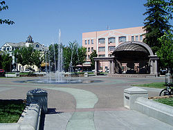
SealNickname(s): City of Roses, City of Trees Location of Chico in California
Coordinates: 39°44′24″N 121°50′8″W / 39.74°N 121.83556°WCoordinates: 39°44′24″N 121°50′8″W / 39.74°N 121.83556°W Country USA State  California
County Butte Settled 1843 Founded 1860 Incorporated January 8, 1872 Founder John Bidwell Government - Type Charter city, Council-manager government - Mayor Ann Schwab - City Council Scott Gruendl Bob Evans Ann Schwab Mary Flynn Mark Sorensen
Jim Walker- City manager David Burkland[1] - State Leg. Sen. Doug LaMalfa (R)
Asm. Dan Logue (R)- U.S. Congress Wally Herger (R) Area[2] - City 33.095 sq mi (85.716 km2) - Land 32.923 sq mi (85.271 km2) - Water 0.172 sq mi (0.446 km2) 0.52% Elevation 245 ft (74 m) Population (2010) - City 86,187 - Density 2,604.2/sq mi (1,005.5/km2) - Metro 212,968 Time zone PST (UTC-8) - Summer (DST) PDT (UTC-7) ZIP Code 95926, 95927, 95928, 95929, 95973, 95976 Area code(s) 530 FIPS code 06-13014 Demonym Chicoan GNIS feature ID 1655890 Website http://www.chico.ca.us Chico is the most populous city in Butte County, California, United States. The population was 86,187 at the 2010 census, up from 59,954 at the time of the 2000 census. The city is a cultural, economic, and educational center of the northern Sacramento Valley and home to both Chico State University and Bidwell Park, one of the country's 25 largest municipal parks and the 13th largest municipally-owned park.[3]
Other cities in close proximity to the Chico Metropolitan Area (population 212,000) include Paradise and Oroville, while local towns and villages (unincorporated areas) include Durham, Cohasset, Dayton, Hamilton City, Nord, and Forest Ranch. The Chico Metropolitan Area is the 14th largest metropolitan statistical area in California.
The official city nickname is "City of Roses", according to the Seal of the City of Chico, California. Chico has been designated a Tree City USA for 27 years by the Arbor Day Foundation.[4]
Contents
History
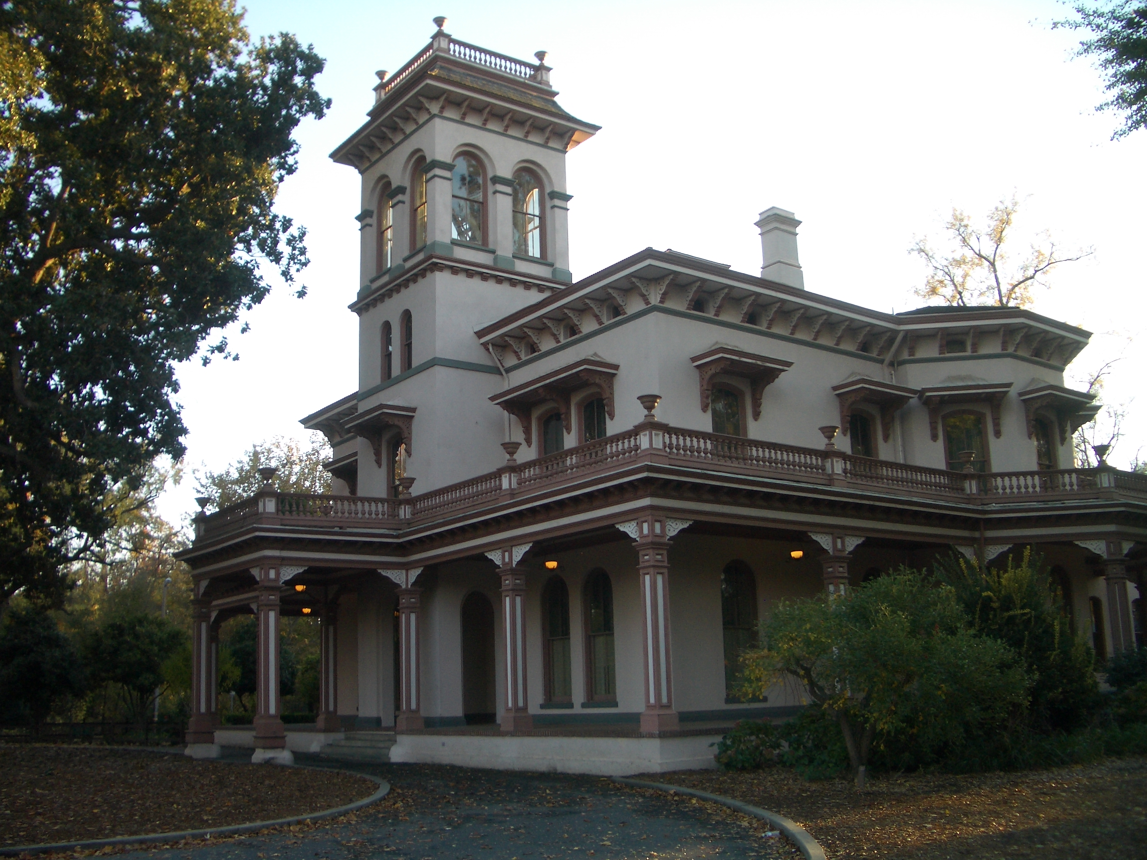
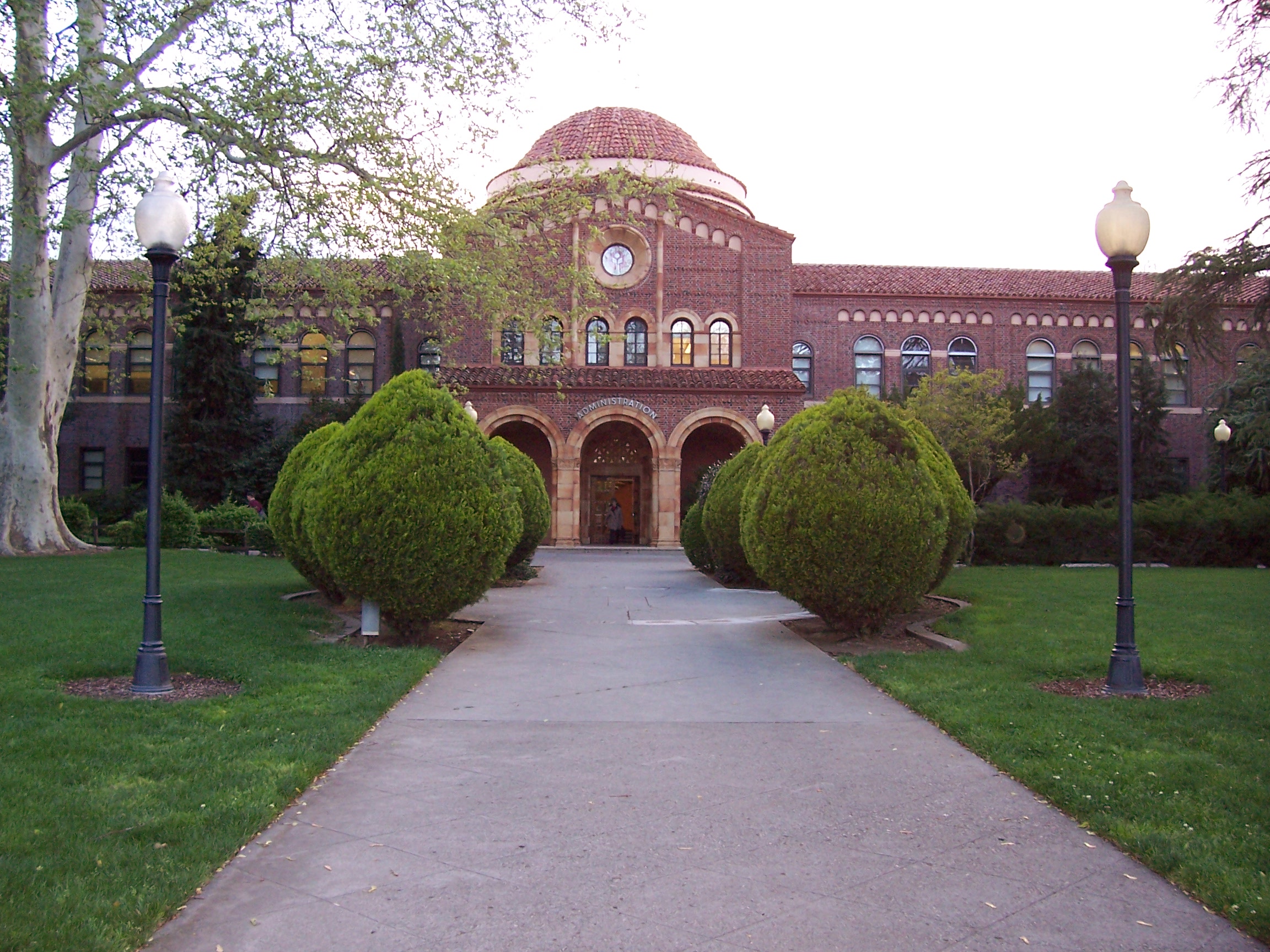
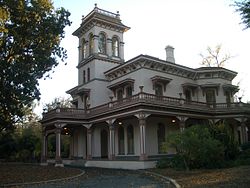 Bidwell Mansion
The original inhabitants of the area now known as Chico were the Mechoopda Maidu Native Americans.
The City of Chico was founded in 1860 by John Bidwell, a member of one of the first wagon trains to reach California in 1843. During the American Civil War, Camp Bidwell (named for John Bidwell, by then a Brigadier General of the California Militia), was established a mile outside Chico, by Lt. Col. A. E. Hooker with a company of cavalry and two of infantry, on August 26, 1863. By early 1865 it was being referred to as Camp Chico when a post called Camp Bidwell was established in northwest California, later to be Fort Bidwell.[5] The city became incorporated January 8, 1872.
Chico was home to a significant Chinese American community when it was first incorporated, but arsonists burned Chico's Chinatown in February 1886, driving Chinese Americans out of town.[6]
Historian W.H. "Old Hutch" Hutchinson identified five events as the most seminal in Chico history. They included the arrival of John Bidwell in 1850, the arrival of the California and Oregon Railroad in 1870, the establishment of the Northern Branch of the State Normal School in 1887, the purchase of the Sierra Lumber Company by the Diamond Match Company in 1900, and the development of the Army Air Base, which is now the Chico Municipal Airport.[7]
Several other significant events have unfolded in Chico more recently. These include the construction and relocation of Highway 99E through town in the early 1960s, Playboy Magazine naming Chico State the number-one party school in the nation in 1987, and the establishment of a "Green Line" on the western city limits as protection of agricultural lands.
Geography
Location
Chico is located at the northeast edge of the Sacramento Valley, one of the richest agricultural areas in the world. The Sierra Nevada mountains lie to the East, with Chico's city limits venturing several miles into the foothills. To the west, the Sacramento River lies five miles (8 km) from the city limit.[8]
Topography
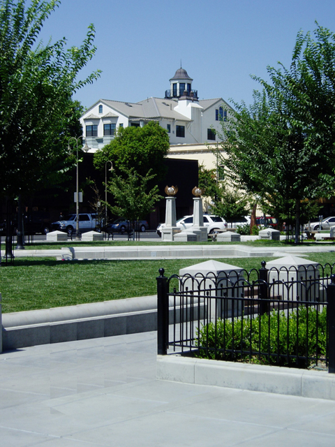
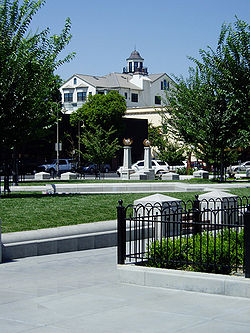 City Plaza in Chico
Chico sits on the Sacramento Valley floor close to the foothills of the Cascade range and the Sierra Nevada range with Big Chico Creek being the demarcation line between the Cascade range (to the north) and the Sierra Nevada range (to the south). The city terrain is on the whole very flat with increasingly hilly terrain beginning at the eastern city limits.
According to the United States Census Bureau, the city has a total area of 27.8 square miles (72 km2), of which 27.7 square miles (72 km2) of it is land and 0.04% is water.
The city is bisected by Bidwell Park, which runs five miles (8 km) from the city center to the crest of the Sierra Nevada range.
The city is also traversed by two creeks and a flood channel, which feeds the Sacramento River. They are named Big Chico Creek, Little Chico Creek, and Lindo Channel (also known as Sandy Gulch, locally).
Street system
The downtown area of Chico is located generally between Big Chico Creek and Little Chico Creek. The downtown has a street grid offset 49.75° from the four cardinal directions. There are numbered streets and avenues, which generally run ENE-WSW. Blocks are usually addressed in hundreds corresponding to the numbered streets and avenues. While the ENE-WSW streets and avenues are numbered, Streets running NNW-SSE are generally named after trees. The part of the 'tree' streets that intersect the CSUC campus spell the word "CHICO" at Chestnut, Hazel, Ivy, Cherry, and Orange Streets.
The main thoroughfare running NW-SE through the city is Business 99, known as Main Street/Broadway (these are one way, SE and NW, respectively, in downtown Chico), Park Avenue, The Esplanade and the Midway. The city streets are designated as "East" or "West" by their relation to this street.
There are numbered streets and avenues both of which flow east-west. This fact can cause some confusion. The "Streets" are situated south of the Chico State campus through downtown, while the "Avenues" are situated north of the Chico State campus through The Esplanade. There are no left turns permitted onto any odd numbered avenue from The Esplanade, in either direction, with the exception of West 11th Ave.
In the numbered streets and avenues and most other streets that intersect The Esplanade, Main, and Park, the west addresses are all numbers whose last two digits are 00 through 49 and the east addresses are all numbers whose last two digits are 50 through 99. There are very few exceptions.
On most Chico streets odd addresses are on the south side of the street.
Standing at the bridge over the Big Chico Creek—where Main Street changes to The Esplanade— and facing north, the odd addresses are on the left (Bidwell Mansion is 525 The Esplanade). This convention holds for all the numbered avenues. However, while facing south the odd addresses are still on the left (i.e., the convention has switched). This convention holds throughout the numbered streets.
Neighborhoods
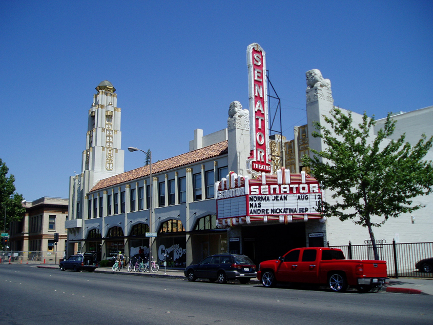
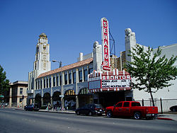 The Senator Theater, completed in 1928 for $300,000, was designed by Timothy L. Pflueger for Michael Naify and the Nasser Brothers
Downtown Chico – This is the main commercial district in Chico. It is located generally between the Big Chico Creek and Little Chico Creek between Wall Street and Salem Street. The Downtown Chico Business Association represents the interests of the downtown to the community. Main Street and Broadway are the two main thoroughfares bisecting the downtown. Ringel Park is the triangular shaped area immediately north of downtown. The Chico City Plaza is the central point of downtown, between Fourth and Fifth Streets. The area of West Ninth Street where Main Street and Oroville Avenue converge is known as The Junction, the southernmost part of the downtown. "The Junction," as the confluence of Humboldt Road and the old Shasta Stage Road (now Main Street and The Esplanade) got its name in the early 1860s when John Bidwell and partners established a company that created a stage line between Chico and Susanville, ultimately leading to Ruby City, Idaho, and the rich gold strikes there. This is the place where Humboldt Road began; it is now called Humboldt Avenue until it reaches the Highway 99 freeway, then regains the Humboldt Road name on the eastern side as it continues into the foothills. "The Junction" was for some years a business district unto itself, providing goods and services to people arriving at and departing from the stage depot.
South Campus – The South Campus neighborhood is the area bounded by West Second Street, Salem Street, West Ninth Street and the western city limits (which is called "The Green Line"). Historically, this area was the first residential area established in the city. Currently, it is the most densely populated area of the city. The South Campus Neighborhood Association represents the interests of the neighborhood to the community. South Campus is a dynamic residential neighborhood consisting overwhelmingly of young renters under thirty-five, and specifically Chico State students. The intersection of Fifth and Ivy streets is a neighborhood commercial core sometimes referred to locally as "Five and I." There are many fraternity and sorority houses in the area, and the city has designated a "Fraternity/Sorority Overlay Zone", largely contiguous with the neighborhood. South Campus is home of Craig Hall and Depot Park.
Barber – The Barber neighborhood is a working class residential neighborhood generally south of Little Chico Creek and west of Park avenue. The Barber Neighborhood Association represents the interests of the neighborhood to the community. This neighborhood was originally built to house the employees of the adjacent Diamond Match Factory. The neighborhood was named after Ohio Columbus Barber, president of the Diamond Match Company. Today, the Diamond Match property is designated for a future development called Barber Yard.
Chapmantown – This is a working-class residential neighborhood entirely surrounded by area inside the city of Chico, but which itself is not a part of the city. Rather, it is under the jurisdiction of the County of Butte. Chapmantown is currently known as the area bounded by Little Chico Creek, Boucher Street, Guill Street and East Sixteenth Street. The neighborhood south of East Twentieth Street to the east of Fair street is also referred to as Chapmantown. Historically, Chapmantown referred to everything east of Mulberry street, but that is no longer the case. Due to not being within city limits, there are no sidewalks, sewers, or any other city services. However, there are also none of the regulations associated with the municipality either (prohibition on chicken coops, burn permits, etc.) The neighborhood is home to The Dorothy F. Johnson Neighborhood Center, a facility of the Chico Area Recreation District. The neighborhood is named after Augustus Chapman.
The Avenues – A relatively new name that refers to the area north of Big Chico Creek historically known as Chico Vecino. This area includes the numbered avenues that intersect The Esplanade. This residential neighborhood is adjacent to the northern boundary of Chico State campus and is south of Lindo Channel. The neighborhood also is home to Enloe Medical Center.
Mansion Park is the high end residential neighborhood adjacent to the Bidwell Mansion, and immediately between the northeast corner of the Chico State campus and Chico High School. This neighborhood is notable for its being a preferred parking zone for residents with permits only, located in an area of the city with very impacted parking. This neighborhood is home to the Albert E. Warrens Reception Center (formerly the Julia Morgan House), and the Bidwell Amphitheatre. Originally, home to mostly university professors and staff, other professionals and upper middle class families now also call it home.
Doe Mill is the developing urban residential neighborhood generally north of East Twentieth Street and East of Bruce Road.
Nob Hill is the developing residential neighborhood west of Bruce Road and north of Highway 32.
California Park is the developing residential neighborhood east of Bruce Road and north of Highway 32. This area contains a smaller area known as Canyon Oaks.
Aspen Glen is the residential neighborhood east of the Esplanade and north of East Shasta avenue. Many streets here are named after things associated with Colorado.
Cussick Area Neighborhood is an assortment of different housing types on the northwest end of town. It is flanked by orchards, the Esplanade, and West East Avenue. The deeper you go into the neighborhood, the larger and more beautiful the houses get in this peaceful backside of town.
Big Chico Creek Estates is a middle class development in the southwest area of town. Backed by the beautiful Big Chico Creek, and very close to Chico's newest elementary school.
Little Chico Creek Estates a small, middle-class development built in southeast Chico on what was at one time an olive orchard. Placed between Little Chico Creek and a small flood-control channel, the development extends from Bruce Road at the western end to the mouth of Stilson Canyon at the eastern end, where it is separated from the homes in the canyon by the fork in the two waterways at the diversion dam. Little Chico Creek Estates is located very close to Hank Marsh Junior High School as well as Little Chico Creek Elementary School and various shopping centers including the Chico Mall.
Connors Neighborhood is a very small neighborhood squeezed between East East Ave and Rio Lindo and between the Esplanade and Highway 99. Connors Neighborhood is made up of Connors Ave and White Ave, along with a couple of courts and circles. This neighborhood was incorporated into Chico in 2003, the state plans to add sewers in Q1 of 2011.
Other neighborhoods include South Park, North Park, Vallombrosa, Baroni Park, and Hancock Park.
Chico also is home to several large new urbanist neighborhoods, either planned or under construction, including Doe Mill, Barber Yard, Meriam Park, and Westside Place.
The above mentioned "neighborhoods" do not include large sections of Chico. There are numerous other areas that each have unique characteristics and attractions. While some of these areas were not so long ago outside of city limits, they have always been a part of the Chico community. Most of these areas are well established with a high per centage of residents who have lived there for more than twenty years. In the older areas of the outlying neighborhoods, it is not uncommon to find households that have been there for fifty or even more years.
Parks and Creekside Greenways

- Parks
- Verbena Fields: This site is a former quarry that is currently being restored into a natural park. The project will expand and improve seasonal wetlands, increase the floodplain width, restore native plantings, establish Mechoopda cultural planting areas, construct a walking trail loop, and provide public education.
- Baroni Park
- Bidwell Park
- Children's Playground
- Depot Park
- DeGarmo Park
- East 20th St at Notre Dame Park (undeveloped)
- Hancock Park
- Henshaw Park (undeveloped)
- Hooker Oak Recreation Area
- Ceres Park (undeveloped)
- Humboldt Park (Humboldt at Willow)
- Nob Hill/Husa Ranch Park
- Peterson Park
- City Plaza
- Ringel Park
- Skateboard Park
- Wildwood Park
- Martin Luther King Park
- Chapman Park
- Oak Way Park
- Rotary Park (Wall Street)
- Rotary Park (Sixteenth and Broadway)
- Creekside Greenways
- Little Chico Creek
- Mud Creek
- Sycamore Creek
- Commanche Creek
- Sandy Gulch (Lindo Channel) Greenway
- Bear Hole (in Upper Bidwell Park)
- Alligator Hole (in Upper Bidwell Park)
- Salmon Hole (in Upper Bidwell Park)
Climate
Chico and the Sacramento Valley have a typically Mediterranean climate. Temperatures can rise well above 100 °F (38 °C) in the summer. Chico is one of the top metropolitan areas in the nation for number of clear days.[9] [10] Winters are fairly mild and wet, with the most rainfall coming in January. The average annual rainfall is 26 inches (660 mm). Tule fog is often present during the autumn and winter months.[11]
Climate data for Chico Month Jan Feb Mar Apr May Jun Jul Aug Sep Oct Nov Dec Year Record high °F (°C) 77
(25)82
(28)93
(34)98
(37)108
(42)115
(46)117
(47)116
(47)114
(46)103
(39)91
(33)76
(24)117
(47)Average high °F (°C) 53
(12)59
(15)63
(17)70
(21)78
(26)86
(30)90
(32)89
(32)82
(28)69
(21)58
(14)52
(11)70.8
(21.5)Average low °F (°C) 35
(2)39
(4)42
(6)45
(7)50
(10)57
(14)60
(16)59
(15)53
(12)46
(8)39
(4)34
(1)46.6
(8.1)Record low °F (°C) 12
(−11)16
(−9)23
(−5)27
(−3)30
(−1)38
(3)40
(4)38
(3)35
(2)23
(−5)20
(−7)11
(−12)11
(−12)Precipitation inches (mm) 5.89
(149.6)5.24
(133.1)4.83
(122.7)1.97
(50).97
(24.6).50
(13).06
(1.5).19
(4.8).72
(18.3)2.59
(65.8)4.00
(101.6)5.12
(130)32.08
(814.8)Source: The Weather Channel[12] Demographics
2010
The 2010 United States Census[13] reported that Chico had a population of 86,187. The population density was 2,604.2 people per square mile (1,005.5/km²). The racial makeup of Chico was 69,606 (80.8%) White, 1,771 (2.1%) African American, 1,167 (1.4%) Native American, 3,656 (4.2%) Asian, 210 (0.2%) Pacific Islander, 5,437 (6.3%) from other races, and 4,340 (5.0%) from two or more races. Hispanic or Latino of any race were 13,315 persons (15.4%).
The Census reported that 83,009 people (96.3% of the population) lived in households, 2,591 (3.0%) lived in non-institutionalized group quarters, and 587 (0.7%) were institutionalized.
There were 34,805 households, out of which 9,222 (26.5%) had children under the age of 18 living in them, 11,745 (33.7%) were opposite-sex married couples living together, 3,975 (11.4%) had a female householder with no husband present, 1,729 (5.0%) had a male householder with no wife present. There were 2,806 (8.1%) unmarried opposite-sex partnerships, and 295 (0.8%) same-sex married couples or partnerships. 10,419 households (29.9%) were made up of individuals and 3,100 (8.9%) had someone living alone who was 65 years of age or older. The average household size was 2.38. There were 17,449 families (50.1% of all households); the average family size was 2.97.
The population was spread out with 16,771 people (19.5%) under the age of 18, 20,622 people (23.9%) aged 18 to 24, 22,360 people (25.9%) aged 25 to 44, 17,256 people (20.0%) aged 45 to 64, and 9,178 people (10.6%) who were 65 years of age or older. The median age was 28.6 years. For every 100 females there were 98.2 males. For every 100 females age 18 and over there were 96.8 males.
There were 37,050 housing units at an average density of 1,119.5 per square mile (432.2/km²), of which 14,878 (42.7%) were owner-occupied, and 19,927 (57.3%) were occupied by renters. The homeowner vacancy rate was 2.0%; the rental vacancy rate was 5.8%. 36,008 people (41.8% of the population) lived in owner-occupied housing units and 47,001 people (54.5%) lived in rental housing units.
2000
As of the census[14] of 2000, there were 59,954 people, 23,476 households, and 11,644 families residing in the city. The population density was 2,161.0 people per square mile (834.5/km²). There were 24,386 housing units at an average density of 879.0 per square mile (339.4/km²). The racial makeup of the city was 82.4% White, 2.0% Black or African American, 1.3% Native American, 4.2% Asian, 0.2% Pacific Islander, 5.7% from other races, and 4.3% from two or more races. Hispanic or Latino of any race were 12.3% of the population.
There were 23,476 households out of which 27.1% had children under the age of 18 living with them, 34.4% were married couples living together, 11.3% had a female householder with no husband present, and 50.4% were non-families. 29.3% of all households were made up of individuals and 8.1% had someone living alone who was 65 years of age or older. The average household size was 2.42 and the average family size was 3.03.
In the city the population was spread out with 21.1% under the age of 18, 27.0% from 18 to 24, 26.8% from 25 to 44, 15.2% from 45 to 64, and 9.9% who were 65 years of age or older. The median age was 26 years. For every 100 females there were 96.4 males. For every 100 females age 18 and over there were 93.9 males.
The median income for a household in the city was $29,359, and the median income for a family was $43,077. Males had a median income of $35,548 versus $26,173 for females. The per capita income for the city was $16,970. About 12.7% of families and 26.6% of the population were below the poverty line, including 19.2% of those under age 18 and 8.2% of those age 65 or over.
Economy
Much of the local economy is driven by the presence of California State University, Chico. Industries providing employment: educational, health and social services (30.3%), retail trade (14.9%), arts, entertainment, recreation, accommodation and food services (12.6%).[15]
In the last two decades Chico has emerged as a regional retail shopping destination. Chico's largest retail district is focused around the Chico Mall on East 20th Street. In the two decades since the Chico Mall was constructed, many national retailers have located nearby, including Target, Kohl's, Best Buy, and Wal-Mart. In January 2008, plans were unveiled to remodel the Chico Mall by demolishing the westernmost portion of the mall (previously home to Troutman's) and constructing an open air "lifestyle" shopping center that will connect the mall with the Kohl's shopping center nearby.
Chico is also home to the North Valley Plaza Mall, which was the city's first enclosed shopping center. Construction on this mall began in 1965 and it was the city's largest shopping center until the Chico Mall was completed in 1988. For a few years the "old" mall and the "new" mall competed against one another. The North Valley Plaza Mall was dealt a blow when JCPenney, one of the old mall's anchors, moved to the Chico Mall in 1993. The "old" mall slowly declined with increasing vacancies. After several failed attempts at revitalization, the North Valley Plaza Mall was overhauled in 2002, with the center of the mall demolished. Although several large retailers, such as Trader Joe's, and Tinseltown Theater, are still operating, there has been an effort to make the North Valley Plaza more of a neighborhood shopping center, rather than a regional one. Mervyn's anchored the mall at the west end, filling the spot vacated by JCPenney, but declared bankruptcy in 2008 and liquidated its entire stock by the end of December of that year. The entire Mervyn's chain ceased operations just before the end of the year.
Chico's downtown is a thriving area for unique, independent retail shops and restaurants. Farmers markets attract crowds on Saturday mornings and Thursday evenings. City Plaza hosts free concerts regularly during the summer. Performance venues large and small, bars, coffee shops, bookstores and city offices contribute to a lively and flavorful experience.
Top employers
According to the City's 2010 Comprehensive Annual Financial Report, [16] the top employers in the city are:
# Employer # of employees 1 Enloe Medical Center 2,275 2 California State University, Chico 1,825 3 Chico Unified School District 1,400 4 City of Chico 442 5 Wal-Mart 400 6 Sierra Nevada Brewing Company 325 7 Build.com 267 8 SunGuard 200 9 Chico Enterprise-Record 150 10 Smucker's (Knudsen) 125 Additionally, build.com, with 267 employees, was named in 2011 by Internet Retailer Magazine as number 80 of the top 100 online retailers, surpassing Lowe's, they are now the 2nd largest e-tailer in Home Improvement.[17][18]
Government
Municipal
The City of Chico is a charter city. The City of Chico's administration offices are located at 411 Main Street immediately adjacent to the City Council Chambers. Chico's city council consists of seven nonpartisan councilmembers each elected at-large in November of even-numbered years. Their terms begin on the first Tuesday in December and end on the first Tuesday in December four years thereafter. The mayor is chosen by and from among the council members and serves for two years. City council meetings are on the first and third Tuesday of each month.
The City Council appoints members of the Airport Commission, Architecture Review Board, Arts Commission, Bidwell Park and Playground Commission, Human Resources Commission, and Planning Commission.
The current council members are Scott Gruendl, Ann Schwab, Mary Flynn, Andy Holcombe, Jim Walker, Mark Sorensen, and Bob Evans. The council holds a 5–2 liberal/progressive majority. The most recent election November 2, 2010 resulted in Greundl, Flynn being re-elected and Sorensen being elected.
County
The citizens of Chico are represented in the Butte County Board of Supervisors by the District Two Supervisor Larry Wahl and the District Three Supervisor Maureen Kirk.
The Butte County Association of Governments office is located in Chico at 2580 Sierra Sunrise Terrace, Suite 100.
State
The citizens of Chico, as members of California's 3rd Assembly District, are represented by Dan Logue (R, Linda) in the California State Assembly; and as members of California's 4th Senate District, are represented by Doug LaMalfa (R, Richvale) in the California State Senate.
Federal
The citizens of Chico, as members of California's 2nd congressional district (which has a PVI of R +13[19]) are represented by Wally Herger (R, Rio Oso) in the United States House of Representatives.
Education
The Chico Unified School District includes all of the greater Chico area including area not within the city limits.
Primary education
Elementary
- Blue Oak Charter School
- Chapman Elementary School
- Chico Country Day School
- Citrus Elementary School
- Cohasset Elementary School
- Emma Wilson Elementary School,
- Forest Ranch Elementary School
- Hooker Oak Elementary School
- John A. McManus Elementary School
- Little Chico Creek Elementary School
Junior high (7th and 8th)
- Chico Country Day School
- Bidwell Junior High School
- Chico Junior High School
- Henry M. "Hank" Marsh Junior High School
- Sherwood Montessori Charter School
Secondary education
Public
- Chico High School
- Pleasant Valley High School
In 1998, city voters approved a bond to build a third comprehensive high school that was to be called Canyon View High School. However, after a protracted search for an acceptable site, the school district opted not to build the new high school, a decision based largely on declining enrollment figures. The money from the bond is now planned to be used for improvements at Chico and Pleasant Valley high schools.
Alternative education
- Academy For Change—Community Day School
- Fairview High School—Continuation School
- Core Butte Charter School—Charter School
- Blue Oak Charter School—a Waldorf methods public school (includes grades K through 8)
- [[Sherwood Montessori Charter School]–a Montessori public school (grades K through 8)
Private
- King's Christian School
- Notre Dame Catholic School
- Champion Christian School
- Chico Oaks Adventist School
- Pleasant Valley Baptist School
- Chico Christian School and Preschool
Higher education
- California State University, Chico (Chico State)
- Butte College
- Cal Northern School of Law
- University of Phoenix
Culture
Museums
The Chico Museum first opened in February 1986 in the former Carnegie Library building in downtown Chico. It currently features the only circus exhibit of its kind in the Western United States. The museum has two main galleries, which host a variety of temporary and traveling exhibits. In addition, the museum has two smaller, permanent galleries displaying the diverse history of Chico. The Chico Museum is run by the Far West Heritage Association, which also runs the Patrick Ranch Museum. The museum is free and donations are graciously accepted.
The Chico Air Museum is an aviation museum, which opened in 2004. Several aircraft are displayed outdoors, with smaller displays inside a nearby building, one of the few remaining from World War II.
The National Yo-Yo Museum is the country's largest collection of yo-yo artifacts, which also includes a four-foot-tall yo-yo that is dropped with a crane every few years, the world's largest functional yo-yo. Classes are available as well for those new to yo-yo and those who just want to get better. An art museum, the Chico Art Center is also located in the city.
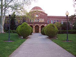
Two other historical buildings are also museums. Bidwell Mansion is a Victorian house completed in 1868, and the former home of John and Annie Bidwell. Bidwell Mansion is a California State Historical Park. Stansbury House, former home of physician Oscar Stansbury, is a museum of 19th-century life.[21]
The Valene L. Smith Museum of Anthropology on the CSU, Chico campus presents temporary exhibits researched, designed and installed primarily by students. The current exhibition is "Living on Top of the World: Arctic Adaptation, Survival and Stewardship." The museum was renamed November 18, 2009 by the CSU Board of Trustees in honor of professor emerita Valene L. Smith, whose contributions and commitments to the museum have totaled over $4.6 million. The grand opening to celebrate the new exhibition as well as the contributions of Dr. Smith is on January 28, 2010 and the exhibition will run until May 2010. The museum is located across from the main entrance of the Miriam Library, next to the Janet Turner Print Museum.[22]
Construction started on the Gateway Science Museum (formerly the Northern California Natural History Museum) in 2008 and was completed on February 27, 2010. In the works for more than 10 years, the Gateway Science Museum is the leading center for science education and Northern California's local history, natural resources, seacoast, valley, and surrounding foothills and mountains.[23]
Art and theatre
About 40 murals and several galleries can be found in the city, including Chico Paper Company, 1078 Gallery, Avenue 9, The Space, 24-Hour Drive-By, Ray Ray and numerous other galleries. The theatres in Chico include Blue Room Theatre, Theatre ETC, Chico Cabaret, Chico Performances, Chico Theater Company, and Theatre on the Ridge. The California State University, Chico Theatre Department also offers a variety of entertainment throughout the school year. In 2003, author John Villani named Chico one of the top 10 Best Small Art Towns in America.[24]
Points of interest
Chico is the site of Bidwell Park, the ninth-largest municipally-owned park in the United States, Bidwell Mansion State Historic Park, the Chico University Arboretum.
Sierra Nevada Brewing Company, the second-largest craft brewer in the country, is based in Chico. Butte Creek Brewing Company, maker of handcrafted organic ales, is also located in Chico.
Chico has the tallest building north of Sacramento in California: Whitney Hall, a nine-story dormitory on the Chico State college campus.
The Meriam Library on the CSUC campus is named after Ted Meriam. The building has more square footage than any other building in California north of Sacramento.
The State of California, Office of Statewide Health Planning and Development defines Enloe Medical Center as a General Acute Care Hospital in Chico with a Level II Trauma Center and Basic emergency care as of August 22, 2006. The facility is located at 1531 The Esplanade at (NAD83) latitude/longitude 39°44′33″N 121°51′00″W / 39.7425°N 121.85°W.
The Hooker Oak, formerly the largest Valley Oak in the world, was located at Hooker Oak Recreation Area in Bidwell Park.
Located in urban Chico, the Mechoopda Maidu Indian Tribe of Chico Rancheria is at 125 Mission Ranch Blvd.
Bidwell Municipal Golf Course, United States Department of Agriculture Plant Introduction Garden, Canyon Oaks Golf Course, Diamond Match Factory, Chico Museum, Chico Municipal Center, Dorothy F. Johnson Neighborhood Center, Veterans Memorial Building, Craig Hall, Stansbury House, Scrappy Dog, Madison Bear Garden, Chico Creek Nature Center, Chico Community Observatory, Big Chico Creek Ecological Reserve, Chico Area Recreation and Park District, Bidwell Amphitheatre, Honey Run Covered Bridge, Senator Theatre[25], A. H. Chapman House, Allen-Sommer-Gage House, Patrick Ranch House, Silberstein Park Building, Pioneer Days.
Sports
Chico is home to Nettleton Stadium (also called The Net) baseball stadium on the California State University campus. It is the home field for the CSU Chico Baseball team, the Chico State Wildcats in NCAA Division 2, and the Chico Outlaws of the Golden Baseball League.
Chico is also home of the Silver Dollar Speedway, a race track at the Butte County Fairgrounds used for sprint car racing.
Chico is one of few cities to be home to two championship baseball teams in two different leagues simultaneously. The CSUC Wildcats were champions in both the 1997 and 1999 Division II College World Series. The Chico Heat were also champions in the Western Baseball League in 1997.
Bicycling
Chico has also gained a reputation as being a bicycle-friendly city. In 1997, Chico was ranked as the number-one cycling city in the nation by Bicycle Magazine[citation needed] and also hosts the Wildflower Century, an annual 100-mile (160 km) bike ride throughout Butte County every April, put on by Chico Velo Cycling Club. The city is in the process of creating a network of bicycle paths, trails and lanes. Some notable bicycle routes include a path leading from The Esplanade to the Chico Airport, a path running from downtown to East Avenue parallel to Hwy 32 along the railroad, a path along Park Avenue continuing down the Midway toward Durham, a path following Little Chico Creek from Bruce Road to Highway 99, and a series of paths throughout Bidwell Park, and the Steve Harrison Memorial Bike Path, which bypasses Skyway and takes riders out to Honey Run Road.
Former sports organizations
Chico is former home of the Chico Rooks (Soccer), and the Chico Heat (Baseball – Western Baseball League).
Agriculture
The city of Chico, being in the Sacramento Valley, sits amid some of the most fertile soil on earth. The region is an agricultural leader. Almonds are the number one crop in the area, only recently edging out rice. Other crops in the area include walnuts, kiwis, olives, peaches, and plums.
The city is bounded on the west by orchards with thousands of almond trees, and there are still a few pockets of orchards remaining within the contiguous city limits. The trees bloom with a pink/white flower in late February or early March. Millions of bees are brought in for the pollination. The nuts are harvested in late August.
Walnuts are also a major agricultural production in the area north and west of town. Unlike the almond crops of the area, walnuts do not have the same appeal as they do not bloom but they grow much larger and live much longer than almonds, but similar to the almond crops, walnuts are harvested in early September.
There are several Farmers' markets held in Chico: Wednesday mornings, May through November 7:30 am to Noon at the North Valley Plaza; Thursday night market with a street-fair atmosphere is sponsored by the Downtown Chico Business Association from 6–9 p.m. each Thursday night during warm months in downtown Chico on Broadway, between 2nd and 5th Streets; Chico Certified Farmer's Market every Saturday morning (year-round) from 7 am until 1 pm at the Wall Street public parking lot on 2nd and Wall Streets.
Transportation
Air
Chico Municipal Airport serves the area and is north of the city limits. It is served by United Airlines' United Express operated by SkyWest Airlines (San Francisco). On July 31, 1961, the first-ever aircraft hijacking on United States soil occurred at the Chico Municipal Airport. Two men were critically wounded and the hijacker was sentenced to more than 30 years in prison.[26][27]
From 1962 to 2010, the airport was also home to Aero Union, a company that refits surplus military aircraft as fire fighting aircraft, until their move to McClellan Airfield, near Sacramento.
Ranchaero Airport is surrounded by orchards on the west edge of town.
An altitude record for unmanned gas balloons was set in Chico in October 1972 (51.8 km). The record was broken in Japan on May 23, 2002.
Land
Amtrak operates the Chico Amtrak station at Fifth and Orange Streets for the Coast Starlight service. The terminal is partially wheelchair accessible, has an enclosed waiting area, public restrooms, public pay phones, free short-term and long-term parking. Trains run between Seattle and Los Angeles with a northbound, and a southbound train departing from the station daily. The Greyhound bus station is also located at Fifth and Orange Streets.
The North Valley Shuttle has five scheduled runs daily to Sacramento International Airport leaving from Jack's Restaurant at Sixth and Main Streets.
The B-Line (Butte Regional Transit) serves the Chico Urban area with eight routes operating Monday through Saturday and two shuttle routes for CSU, Chico students during the academic year. The Chico Clipper serves the Chico urban area with nine modified vans providing transportation for the elderly and the mobility impaired seven days a week. The transit center in Chico is located at Second and Salem Streets.
Chico is a bronze level Bicycle-friendly community as designated by the League of American Bicyclists. Chico was also named "America's Best Bike Town" by Bicycle magazine in 1997.
Pedicabs are commonly available downtown during the evenings.
Major highways
 State Route 99 and
  State Route 32 intersect in Chico.
Media
Print
- Chico Enterprise-Record
- Chico News & Review
- InsideOut Magazine
- The Orion
- Synthesis (weekly magazine)
- Upstate Business Journal
- Videomaker Magazine
- Growing Up Chico Magazine
- Butte College Roadrunner
- Community Seeds Magazine
- Edible Shasta-Butte (quarterly magazine)
Television
Broadcast television in Northern California, including Chico and Redding English channels KMCA-LP 2 (A1) • KRDN-LP 5 (DS) • KRCR (7.1 ABC, 7.2 Me-TV) • KIXE (9.1 PBS, 9.2 Create, 9.3 World) • KHSL (12.1 CBS, 12.2 CW) • K19FY 19 (TBN) • KCVU (20.1 Fox, 20.2 This TV) • KRVU-LD (21.1 MyNetworkTV) • KZVU-LD (22.1 MyNetworkTV) • KRDT-LD (23.1 Religious, 23.2 HSN) • KNVN (24.1 NBC, 24.2 Antenna TV, 24.5 AccuWX) • KGEC-LP (26.1 RTV, 26.2 Tuff TV, 26.3 My Family TV, 26.4 NASA) • KKPM-CA (28.1 Religious, 28.2 HSN) • K33HH 33 (3ABN) • K50GP 50 (TBN) • K15HV-D (73.1 3ABN)
Spanish channels Regional cable channels Adjacent locals California television: Bakersfield • Chico-Redding • Eureka • Fresno • Los Angeles • Medford OR • Monterey • Palm Springs • Reno NV • Sacramento • San Diego • San Francisco • Santa Barbara • El Centro CA / Yuma AZ
Radio
Radio stations in the Chico, California market By FM frequency By AM frequency By callsign ¹Audio for TV channel 6 (KEFM-LP-Vida)
California Radio Markets: Bakersfield • Chico • Fresno • Los Angeles • Merced • Modesto • Oxnard-Ventura • Palm Springs • Redding • Riverside-San Bernardino • Sacramento • San Diego • San Francisco/Oakland • San Jose • San Luis Obispo • Santa Barbara • Santa Cruz/Salinas/Monterey • Santa Maria-Lompoc • Santa Rosa • Stockton • Victor Valley • Visalia-Tulare-Hanford
Other California Radio Regions: Barstow • Bishop • Crescent City • Diablo Valley • High Desert/Eastern Sierra • Eureka • Fort Bragg-Ukiah • Gilroy/Hollister • Imperial Valley • Marysville/Yuba City • Needles • Red Bluff • Susanville/Sierra Nevada • Tri-Valley • Yreka
Sister cities
 – Tamsui, Taipei (Taiwan) 1985[28]
 – Pascagoula, Mississippi (U.S.) 2005[29]
Rankings
- Chico was ranked No. 1 in Forbes Magazine's "Best Places in America" (May 2000).
- Chico was ranked 13th in Money.Com's "Best Places to Live" survey in 1999.
- Rated No. 16 on Healthy Cities list, by Organic Style magazine, September/October 2003.
- Chico was ranked No. 17 in Farmers Insurance list of Most Secure Cities (2006) for cities under 150,000.
Defense
Chico was designated to be the provisional capital of California, in the event that a disaster occurred that would cause evacuation of Sacramento after a Civil Defense exercise named Operation Chico was deemed a success.[30]
No person shall produce, test, maintain, or store within the city a nuclear weapon, component of a nuclear weapon, nuclear weapon delivery system, or component of a nuclear weapon delivery system under penalty of Chapter 9.60.030 of the Chico Municipal Code.
Notable residents
- Lubna al Qasimi, Minister for Economy and Planning of the United Arab Emirates
- Emily Azevedo, 2010 Winter Olympian in the sport of Bobsled.
- William Berry, political consultant
- John Bidwell, pioneer and founder of Chico
- Annie Bidwell, leader in women's suffrage, and the temperance movement
- Tanya Ballinger, model and actress
- Joseph Bottom, Olympic swimming medalist
- Bill Carter, documentary film maker, author
- Raymond Carver, writer[31]
- Eugene A. Chappie, State Senator, U.S. Representative
- Pat Clements, professional baseball pitcher
- Chris Conley, singer and guitarist for Saves the Day
- Clay Dalrymple, professional baseball catcher
- Leslie Deniz, Olympian
- Amanda Detmer, actress
- Big Poppa E, slam poet
- Pat Gillick, general manager of the Philadelphia Phillies
- Jerry Harris, sculptor
- Russell Hayden
- Joseph Hilbe, Chico State University graduate, author, professor, statistician
- Marty James, musician
- Mat Kearney
- Rick Keene, California politician
- Adnan Khashoggi, billionaire, Saudi arms-dealer and businessman[32]
- Janja Lalich, author, professor, sociologist
- Harold Lang
- Ted W. Lawson, Major U.S Army Air Forces pilot
- Kyle Lohse, professional baseball pitcher
- Pat Mastelotto
- Michael Messner
- Joe Nelson, professional baseball player
- William Morris, glass artist
- Matt Olmstead, writer and producer
- Andranik Ozanian, Armenian general, political and public activist
- The Mother Hips, musical artists
- Kathleen Patterson, politician
- Jackson Pollock, abstract expressionist painter[31]
- Aaron Rodgers, starting quarterback for the Green Bay Packers and Super Bowl XLV MVP
- Ed Rollins, political consultant
- Jason Ross, writer for The Daily Show with Jon Stewart
- Carolyn S. Shoemaker, astronomer[33]
- Gregory Smith[disambiguation needed
 ], clarinetist for Chicago Symphony Orchestra
 - Jessica Smith, reality television star from Survivor
- Mike Sherrard, NFL player
- Jeff Stover, NFL player for the San Francisco 49ers
- Mike Thompson, California politician
- Douglas Tilden, sculptor
- Niki Tsongas, Congresswoman, Massachusetts 5th District widow of Paul Tsongas
- Muddy Waters, football coach
- Bill Wattenburg, scientist, radio talk show host
- Robb Wolf, Paleolithic nutrition expert and author
- Don Young, U.S Representative
See also
- Bidwell Park
- California State University, Chico
- College town
- Butte County
- Operation Chico
- List of California public officials charged with crimes, Chico
References
- ^ Klein, Jenn (5 February 2008). "Council appoints Burkland as permanent city manager". Chico Enterprise-Record. http://www.chicoer.com/news/ci_8182337. Retrieved 4 November 2011.
- ^ "Places". 2010 Census U.S. Gazetteer Files. United States Census Bureau. http://www.census.gov/geo/www/gazetteer/files/Gaz_places_national.txt. Retrieved 4 November 2011.
- ^ "The 100 Largest City Parks" (PDF). The Trust for Public Land. http://www.tpl.org/content_documents/ccpe_100LargestCityParks.pdf.[dead link]
- ^ "2010 Tree City USA Communities". www.arborday.org. Arbor Day Foundation. http://www.arborday.org/programs/treeCityUSA/map.cfm. Retrieved 4 November 2011.
- ^ The war of the rebellion: a compilation of the official records of the Union and Confederate armies. 1. L, Part II-Correspondence, etc.. Washington: Government Printing Office. 1897. pp. 593–594, 1125. http://books.google.com/books?id=Jb89AAAAYAAJ&printsec=frontcover&vq=%22Camp+Bidwell%22&source=gbs_navlinks_s#v=onepage&q=%22Camp%20Bidwell%22&f=false. Retrieved 4 November 2011.
- ^ James W. Loewen. "Chico, CA". Sundown Towns: A Hidden Dimension of American Racism. http://sundown.afro.illinois.edu/sundowntownsshow.php?id=1070. Retrieved 4 November 2011.
- ^ Chico: A 20th century Pictoral History (1995)
- ^ "US Gazetteer files: 2010, 2000, and 1990". United States Census Bureau. 2011-02-12. http://www.census.gov/geo/www/gazetteer/gazette.html. Retrieved 2011-04-23.
- ^ "Chico Facts". www.csuchico.edu. California State University, Chico. http://www.csuchico.edu/pa/chico-facts.shtml. Retrieved 4 November 2011.
- ^ "Chico, CA". CNNMoney.com. Time Warner. http://money.cnn.com/magazines/moneymag/bplive/2006/snapshots/PL0613014.html. Retrieved 4 November 2011.
- ^ "All about Chico: Facts and figures for where you are". Chico News & Review. 4 Novermber 2004. http://www.newsreview.com/chico/Content?oid=oid%3A32555. Retrieved 4 November 2011.
- ^ "Average Weather for Chico, CA – Temperature and Precipitation". June 2011. http://www.weather.com/outlook/travel/businesstraveler/wxclimatology/monthly/graph/95973?from=36hr_bottomnav_business. Retrieved December 16, 2008.
- ^ All data are derived from the United States Census Bureau reports from the 2010 United States Census, and are accessible on-line here. The data on unmarried partnerships and same-sex married couples are from the Census report DEC_10_SF1_PCT15. All other housing and population data are from Census report DEC_10_DP_DPDP1. Both reports are viewable online or downloadable in a zip file containing a comma-delimited data file. The area data, from which densities are calculated, are available on-line here. Percentage totals may not add to 100% due to rounding. The Census Bureau defines families as a household containing one or more people related to the householder by birth, opposite-sex marriage, or adoption. People living in group quarters are tabulated by the Census Bureau as neither owners nor renters. For further details, see the text files accompanying the data files containing the Census reports mentioned above.
- ^ "American FactFinder". United States Census Bureau. http://factfinder.census.gov. Retrieved 2008-01-31.
- ^ "Chico, California". City-Data. http://www.city-data.com/city/Chico-California.html. Retrieved 4 November 2011.
- ^ Chico Finance Department. "Comprehensive Annual Financial Report: Year Ended June 30, 2009" (PDF). City of Chico. http://www.chico.ca.us/finance/documents/FINALCAFRreducedcleaned.pdf.
- ^ "Chico Internet success sold". Chico News & Review. 26 April 2007. http://www.newsreview.com/chico/content?oid=315645. Retrieved 4 November 2011.
- ^ "Top 500 List". Top 500 Guide. Internet Retailer Magazine. http://www.internetretailer.com/top500/list/. Retrieved 4 November 2011.
- ^ "Will Gerrymandered Districts Stem the Wave of Voter Unrest?". Campaign Legal Center Blog. http://www.clcblog.org/blog_item-85.html. Retrieved 4 November 2011.
- ^ "Home page". Sherwood Montessori Charter School. http://www.sherwoodmontessori.org. Retrieved 4 November 2011.
- ^ Museums & Historic Buildings[dead link] Chico city website
- ^ "Valene L. Smith Museum of Anthropology Has Grand Opening Jan. 28 Highlighting New Exhibit: Living On Top Of The World: Arctic Adaptation, Survival And Stewardship". CSU, Chico News. California State University, Chico. http://news.csuchico.edu/2010/01/13/valene-l-smith-museum-of-anthropology-has-grand-opening-jan-28-highlighting-new-exhibit-living-on-top-of-the-world-arctic-adaptation-survival-and-stewardship/. Retrieved 4 November 2011.
- ^ "Home". Gateway Science Museum. http://www.gatewayscience.org. Retrieved 4 November 2011.
- ^ "Arts & Culture". Visitor Information. City of Chico. http://www.chicochamber.com/visitor/arts_culture. Retrieved 4 November 2011.
- ^ "Upcoming shows". JMAX Productions. http://www.senatortheatrechico.com/. Retrieved 4 November 2011.
- ^ Chico: A 20th century Pictorial History
- ^ Welter, Greg (31 July 2006). "First U.S. skyjacking attempt was in Chico, 45 years ago". Chico Enterprise-Record. http://www.chicoer.com/news/ci_4116071. Retrieved 4 November 2011.
- ^ Sheckter, Alan (28 October 2007). "Chico considers establishing permanent sister city guidelines". Chico Enterprise-Record. http://www.chicoer.com/news/ci_7308345. Retrieved 4 November 2011.[dead link]
- ^ Gascoyne, Tom (27 October 2005). "Chico gets a Southern sister". Chico News & Review. http://www.newsreview.com/chico/Content?oid=oid%3A43367. Retrieved 4 November 2011.
- ^ News From Our Past, Chico ER, Dec 6, 2008
- ^ a b Resnick, Carla (6 January 2005). "Bench marks: The city of Chico’s latest public-art projects combine form and function". Chico News & Review. http://www.newsreview.com/chico/Content?oid=oid%3A33357. Retrieved 4 November 2011.
- ^ CSU, Chico News[dead link] Economics Dept. CSUC
- ^ "Astronomer to speak at Community Center". Chico Enterprise-Record. 14 November 2006. http://www.orovillemr.com/news/chico/ci_4660954. Retrieved 4 November 2011.[dead link]
External links
- City of Chico — The Official City Web Site
- Downtown Chico Business Association
- Chico Chamber of Commerce
- City-data.com info on Chico
- Chico Wiki — The Community Wiki for Chico
- Bidwell Park
- California State University, Chico
- WikiMapia for Chico, CA
- Think Local, Chico
- Interactive map of Bidwell Park

Corning Los Molinos, California Cohasset Hamilton City 
Paradise  Chico
Chico 

Willows Yuba City Oroville Shasta Cascade Mountains 
Bodies of Water Shasta Lake • Trinity Lake • Lake Almanor • Eagle Lake • Lake Oroville • Lake Siskiyou • Castle Lake • Lake McCloud • Manzanita Lake • Lake Britton • Whiskeytown LakeRivers Incorporated Cities Counties Parks Lassen Volcanic NP • Whiskeytown-Shasta-Trinity NRA • Lava Beds NM • Castle Crags Wilderness • Mount Shasta Wilderness • South Warner Wilderness • Ahjumawi Lava Springs SP • Bidwell-Sacramento River SP • McArthur-Burney Falls Memorial SP • Plumas-Eureka SP • Bidwell Mansion SHP • William B. Ide Adobe SHP • Woodson Bridge SRAMunicipalities and communities of Butte County, California County seat: Oroville Cities and towns 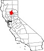
CDPs Bangor | Berry Creek | Butte Creek Canyon | Butte Meadows | Butte Valley | Cherokee | Clipper Mills | Cohasset | Concow | Durham | Forbestown | Forest Ranch | Honcut | Kelly Ridge | Magalia | Nord | Oroville East | Palermo | Rackerby | Richvale | Robinson Mill | South Oroville | Stirling City | Thermalito | Yankee Hill
Unincorporated
communitiesAnita | Barber | Big Bar | Big Bend | Blavo | Brush Creek | Camp Eighteen | Cana | Centerville | Chapmantown | Craig | Cresta | Dayton | Deadwood | DeSabla | Dodge Place | Dodgeland | East Biggs | East Gridley | Elsey | Esquon | Fagan | Feather Falls | Helltown | Hughes Place | Hurleton | Inskip | Irish Town | James | Jonesville | Junction House | Kister | Kramm | Lomo | Lovelock | Lumpkin | Mayaro | Merrills Landing | Merrimac | Mineral Slide | Nelson | Nelsons Crossing | Nimshew | Oak Grove | Old Forbestown | Oregon City | Oroleve | Oroville Junction | Paradise Pines | Parkhill | Peachton | Pentz | Poe | Powellton | Pulga | Ramada | Rancho Llano Seco | Riceton | Richardson Springs | Robinsons Corner | Roble | Rogerville | Shippee | Stirling Junction | Sunnyslope | The Pines | Toadtown | Vista Robles | Wicks Corner | Wyandotte
Ghost towns Appleton | Avon | Bagdad | Bauka | Bayu | Berdan | Bidwell | Bidwell's Bar | Big Ripples | Blinzing | Bloomer | Brush | Butte Creek | Center Ville | Chandon | Channel | Chardon | Clear Creek | Colbys Landing | Coutolenc | Craig | Crouch | David | Dawlytown | Diamondville | Dredge | Enterprise | Eskini | Evans | Evansville | Flea Valley | Gimbal | Gold Lake | Greenland | Gridley Colony Number One | Gridley Colony Number Two | Hamilton | Haselbusch | Hawk Ravine | Hokomo | Holhoto | Honcut City | Hume | Hylandville | Intake | Isaiah | Johnson | Kalkalya | Kulaiapto | Land | Las Plumas | Lava Beds | Long's Bar | Lorraine | Losee | Luce | Lynchburg | Martinsburgh | McKay Meadow | Michopdo | Mill City | Millers Ranch | Mortimer | Moseley | Mulberry | Neals Diggins | Nelson Bar | New Blinzing | Oak Arbor | Ololopa | Omit Bar | Optimo | Oregon Bar | Orloff | Ostrander | Otaki | Pacific Heights | Paki | Paradise Flat | Phillips Corner | Pipers | Platts | Pond | Potter's Bar | Powellton Meadow | Quartz | Richland | Rio Seco | Rock Creek | Savona | Soto | South Fork | Speedway | Stanwood | Summit | Sundale | Sunusi | Swayne | Swedes Flat | Sycamore Crossing | Tadoiko | Taikus | Tarr's Ranch | Tilden | Tolle's Old Diggings | Totoma | Tsuka | Virginia Mills | Wagners | Wagstaff | Ward | West Branch | Whiskey Flat (east) | Whiskey Flat (west) | Yankee Flat | Yauko | Yuman
Categories:- Cities in Butte County, California
- Incorporated cities and towns in California
- Chico, California
- University towns in the United States
- Populated places established in 1843
- Former county seats in California
- Nuclear-weapon-free zones


Wikimedia Foundation. 2010.