- Oroville Junction, California
-
Coordinates: 39°30′35″N 121°39′02″W / 39.50972°N 121.65056°W
Oroville Junction — Unincorporated community — Location in California
 Oroville Junction
Coordinates: 39°30′35″N 121°39′02″W / 39.50972°N 121.65056°W Country United States State California County Butte County Elevation[1] 164 ft (50 m) Oroville Junction (formerly, Tres Vias)[2] is an unincorporated community in Butte County, California. It is located 5 miles (8.0 km) west of Oroville on the abandoned right of way of the Sacramento Northern Railroad,[2] at an elevation of 164 feet (50 m).
References
- ^ U.S. Geological Survey Geographic Names Information System: Oroville Junction, California
- ^ a b Durham, David L. (1998). California's Geographic Names: A Gazetteer of Historic and Modern Names of the State. Quill Driver Books. p. 289. ISBN 9781884995149.
Municipalities and communities of Butte County, California Cities and towns 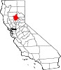
CDPs Bangor | Berry Creek | Butte Creek Canyon | Butte Meadows | Butte Valley | Cherokee | Clipper Mills | Cohasset | Concow | Durham | Forbestown | Forest Ranch | Honcut | Kelly Ridge | Magalia | Nord | Oroville East | Palermo | Rackerby | Richvale | Robinson Mill | South Oroville | Stirling City | Thermalito | Yankee Hill
Unincorporated
communitiesAnita | Barber | Big Bar | Big Bend | Blavo | Brush Creek | Camp Eighteen | Cana | Centerville | Chapmantown | Craig | Cresta | Dayton | Deadwood | DeSabla | Dodge Place | Dodgeland | East Biggs | East Gridley | Elsey | Esquon | Fagan | Feather Falls | Helltown | Hughes Place | Hurleton | Inskip | Irish Town | James | Jonesville | Junction House | Kister | Kramm | Lomo | Lovelock | Lumpkin | Mayaro | Merrills Landing | Merrimac | Mineral Slide | Nelson | Nelsons Crossing | Nimshew | Oak Grove | Old Forbestown | Oregon City | Oroleve | Oroville Junction | Paradise Pines | Parkhill | Peachton | Pentz | Poe | Powellton | Pulga | Ramada | Rancho Llano Seco | Riceton | Richardson Springs | Robinsons Corner | Roble | Rogerville | Shippee | Stirling Junction | Sunnyslope | The Pines | Toadtown | Vista Robles | Wicks Corner | Wyandotte
Ghost towns Appleton | Avon | Bagdad | Bauka | Bayu | Berdan | Bidwell | Bidwell's Bar | Big Ripples | Blinzing | Bloomer | Brush | Butte Creek | Center Ville | Chandon | Channel | Chardon | Clear Creek | Colbys Landing | Coutolenc | Craig | Crouch | David | Dawlytown | Diamondville | Dredge | Enterprise | Eskini | Evans | Evansville | Flea Valley | Gimbal | Gold Lake | Greenland | Gridley Colony Number One | Gridley Colony Number Two | Hamilton | Haselbusch | Hawk Ravine | Hokomo | Holhoto | Honcut City | Hume | Hylandville | Intake | Isaiah | Johnson | Kalkalya | Kulaiapto | Land | Las Plumas | Lava Beds | Long's Bar | Lorraine | Losee | Luce | Lynchburg | Martinsburgh | McKay Meadow | Michopdo | Mill City | Millers Ranch | Mortimer | Moseley | Mulberry | Neals Diggins | Nelson Bar | New Blinzing | Oak Arbor | Ololopa | Omit Bar | Optimo | Oregon Bar | Orloff | Ostrander | Otaki | Pacific Heights | Paki | Paradise Flat | Phillips Corner | Pipers | Platts | Pond | Potter's Bar | Powellton Meadow | Quartz | Richland | Rio Seco | Rock Creek | Savona | Soto | South Fork | Speedway | Stanwood | Summit | Sundale | Sunusi | Swayne | Swedes Flat | Sycamore Crossing | Tadoiko | Taikus | Tarr's Ranch | Tilden | Tolle's Old Diggings | Totoma | Tsuka | Virginia Mills | Wagners | Wagstaff | Ward | West Branch | Whiskey Flat (east) | Whiskey Flat (west) | Yankee Flat | Yauko | Yuman
Categories:- Butte County, California geography stubs
- Populated places in Butte County, California
- Unincorporated communities in California


Wikimedia Foundation. 2010.