- Concow, California
-
Concow — census-designated place — Location in Butte County and the state of California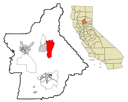
Coordinates: 39°44′14″N 121°30′52″W / 39.73722°N 121.51444°WCoordinates: 39°44′14″N 121°30′52″W / 39.73722°N 121.51444°W Country  United States
State  California
County Butte Government – N/A – State Senate Doug LaMalfa (R) – State Assembly Dan Logue (R) – U. S. Congress Wally Herger (R) Area[1] – Total 27.780 sq mi (71.950 km2) – Land 27.406 sq mi (70.981 km2) – Water 0.374 sq mi (0.969 km2) 1.35% Elevation 2,628 ft (801 m) Population (2010) – Total 710 – Density 25.6/sq mi (9.9/km2) Time zone Pacific (PST) (UTC-8) – Summer (DST) PDT (UTC-7) ZIP code 95965 Area code(s) 530 FIPS code 06-16035 GNIS feature IDs 1867007; 2407652 U.S. Geological Survey Geographic Names Information System: Concow, California; U.S. Geological Survey Geographic Names Information System: Concow, California Concow (formerly, Con Cow)[2] is an unincorporated community and census-designated place[3] (CDP) in Butte County, California, United States. It is named after the Native American tribe that is indigenous to the area, the Concow Maidu [1]. The original inhabitants of the area had a diet of Salmon from the Feather River, acorns and pine nuts from the trees in the area, venison, and other sources of food which abounded in the California foothills. The population was 710 at the 2010 census.
Contents
History
"In the beginning Wahno-no-pem, the Great Spirit, made all things. Before he came, everything on the earth and in the skies was hidden in darkness and in gloom, but where he appeared he was the light. From his essence, out of his breath, he made the sun, the moon, and the countless stars, and pinned them in the blue vault of the heavens."[4]
There is no indication that there was contact with the KonKow tribe during the 1697–1821 Spanish colonization, the 1821–1846 Mexican governance, or the spread of the Californio slave ranchos. The concow region is 20 miles from the city Oroville - in spanish meaning 'town of gold' - and the town Chico was named for Rancho Arroyo Chico - meaning little creek - an 1844 land grant by the Mexican authorities two years before California was invaded by United States forces; an indication there was a minimal Mexican presence in the concow region.
Starting in 1828 northern trappers including Jedediah Smith, Michel Laframboise, and John Work first made contact with the Concow region Maidu [5] and permanent settlements began in 1856.[2] Soon began death from diseases, such as malaria, that the Maidu have no natural immunity. In addition to disease, in 1853 the State of California ordered all non-European people of California - including the Maidu - exterminated in return for a $5.00[6] ($134.95 in 2010 US$)[7] cash bounty for each verified male killed and a lesser cash bounty for a dead woman or child. The resulting debt became known as the "California War Debt" or "Army Appropriations Bill"[8] and in 1854 - though not entirely clear why[9], as Secretary of War Jefferson Davis wrote California that their 'war' expenditures could not be authorized without the original bills of sale to verify the purpose was one intended by congress[10]- California was reimbursed $924,259.65 ($23.4M 2010US) by the United States Federal Government, and again reimbursed $229,981.67 in 1861 for the intervening years [11]. Sometimes children could be sold for more than the per claim amount allowed and so survivors of 'hunts' were enslaved [12] as provided by the Act of 1850 for the Government and Protection of Indians [13]. Their fictionalized but true in spirit story is told by the real person Ishi, who may have been part or full Maidu.
By 1862, after a decade of forcible removals, the last of the native Concow inhabitants were kept on a cramped reservation at Round Valley with unrelated people relocated from surrounding regions. The poor camp conditions and an imminent winter disaster under the supervision of indian agent James Short [14] forced a large group of men, women, children, and elderly to set out without provisions for the 130 miles back to their home in the Concow Valley[15]. They made it as far as present day Chico where they were placed in a camp at Bidwell's old river landing - now under Lake Oroville - and employed constructing the Chico-Humbolt road. The following spring three young children were attacked with the two boys killed and the kidnapped girl escaping after being forced to walk to a village near present day Concow in what became known as the Pence massacre, the murders were 9 miles from the present day Concow CDP - the KonKow people were blamed [16] [17]. These events happened amid documented incidences of local whites dressing as Indians and committing crimes [18] and numerous mule-trains that were attacked and plundered by the various sierra peoples. In the following days 611 KonKow people were murdered and a vigilante group in a compromise with those who wanted the killing to stop gave four determined as 'bad people' a running start before opening fire and killing two [19]. Under a resolution passed at a mass meeting of the public at Pence Ranch on July 27th [20] [21] [22] a volunteer posse of 500 white men sought to kill or remove every non-white from Butte County; they rounded up 461 people from the surrounding area including those at Bidwell's Landing - for the kidnapping and killing, two were tied to a tree and executed by firing squad [23]. The local US government representative Major George M. Hanson, Superintendent of Indian Affairs, Northern California, and the State Militia representative Captain Augustus W. Starr sent July 31st to asses the situation were unsure what to do with the popular movement or how to stop the acts of vigilante justice. The subsequent commanders of Camp Bidwell during the month of August, Captain Alfred Morton and then Major Ambrose E. Hooker[24] - are absent in early correspondence from Captain Starr asking for guidance with the increasing number of Konkow 'prisoners of war'[25] [26].
After consulting with Superintendent Hanson and superiors Colonel Richard Cloyd Drum and General George Wright, Captain Starr was ordered by General Wright in Post Order No. 6 [27]to lead 23 soldiers of Company F 2nd Regiment California Volunteer Cavalry and move the now imprisoned people the 110 miles from Camp Bidwell back to Round Valley on what became a 20-day death march now remembered as the KonKow Trail of Tears. Despite efforts by the soldiers and the Pence resolution mandated donations raised to provide for provisions, horses and wagons, each day those who could not make the march through the hot arid September Sacramento Valley - where afternoon temperatures top 90°F or over the 6,000 foot crest of the North Coast Ranges - were left behind without food or water and were soon killed by a pack of wild boar that had formed behind and followed the group; the survivors were left at the Round Valley concentration camp to starve through the winter without provisions [28]. The current inhabitants of Concow, including a few Maidus, commonly find relics of the Maidu in the form of beads and stone tools while digging in and around their homes. A post office operated at Concow from 1882 to 1906, renamed from Con Cow to Concow in 1895, and relocated several times.[2]
Geography
According to the United States Census Bureau, the CDP has a total area of 27.78 square miles (71.9 km2), of which, 27.41 square miles (71.0 km2) of it is land and 0.37 square miles (0.96 km2) of it (1.35%) is water.
For unknown reasons the community's name was absent from the US Geological Survey files until 1990. Other nearby communities are The Pines (USGS feature ID 268203), and Deadwood (USGS feature ID 1655957). The community is off State Route 70 east of Cherokee. Concow School is shown on some maps. There is a Concow Dam, Road, and Creek nearby.
Demographics
2010
The 2010 United States Census[29] reported that Concow had a population of 710. The population density was 25.6 people per square mile (9.9/km²). The racial makeup of Concow was 611 (86.1%) White, 0 (0.0%) African American, 24 (3.4%) Native American, 5 (0.7%) Asian, 3 (0.4%) Pacific Islander, 10 (1.4%) from other races, and 57 (8.0%) from two or more races. Hispanic or Latino of any race were 56 persons (7.9%).
The Census reported that 710 people (100% of the population) lived in households, 0 (0%) lived in non-institutionalized group quarters, and 0 (0%) were institutionalized.
There were 302 households, out of which 62 (20.5%) had children under the age of 18 living in them, 146 (48.3%) were opposite-sex married couples living together, 21 (7.0%) had a female householder with no husband present, 11 (3.6%) had a male householder with no wife present. There were 26 (8.6%) unmarried opposite-sex partnerships, and 3 (1.0%) same-sex married couples or partnerships. 85 households (28.1%) were made up of individuals and 25 (8.3%) had someone living alone who was 65 years of age or older. The average household size was 2.35. There were 178 families (58.9% of all households); the average family size was 2.92.
The population was spread out with 124 people (17.5%) under the age of 18, 47 people (6.6%) aged 18 to 24, 126 people (17.7%) aged 25 to 44, 313 people (44.1%) aged 45 to 64, and 100 people (14.1%) who were 65 years of age or older. The median age was 50.4 years. For every 100 females there were 115.8 males. For every 100 females age 18 and over, there were 118.7 males.
There were 360 housing units at an average density of 13.0 per square mile (5.0/km²), of which 251 (83.1%) were owner-occupied, and 51 (16.9%) were occupied by renters. The homeowner vacancy rate was 4.5%; the rental vacancy rate was 3.7%. 572 people (80.6% of the population) lived in owner-occupied housing units and 138 people (19.4%) lived in rental housing units.
Between 2000 and 2010
Concow is a census-designated place (CDP) in Butte County, California, United States. In June and July 2008 the Butte Lightning Complex fire destroyed more than 50% of the structures and possibly reduced the population by a similar proportion, with an unknown affect on the CDP age, race, and income demographics [2][3][4].
2000
Population
At the 2000 census[30] the population was 1,095 and with 319 families residing in the CDP. The population density was 29.1 people per square mile (11.2/km²). There were 571 housing units at an average density of 15.2 per square mile (5.9/km²). In 2008 the Butte Lightning Complex fire destroyed 308 homes [31] In the 2010 census "the biggest [regional] percentage drop was in fire-scarred Concow, down 35.16 percent to a population of 710" [32].
Race
At the 2000 census, the racial makeup of the CDP was 90.68% White. As individuals, in the Concow CDP there are, 10 Blacks or African Americans, 25 Native Americans, 6 Asians, 12 Pacific Islanders, 12 who identify themselves as other races, 47 who identify with two or more races and 52 inhabitants of the Concow region who identify themselves as Hispanic or Latino.
Age
In the CDP the population was spread out with 23% under the age of 18, 4% from 18 to 24 (i.e., 44 individuals), 21% from 25 to 44, 34% from 45 to 64, and 18% who were 65 years of age or older. The median age was 46 years. For every 100 females there were 117.7 males. For every 100 females age 18 and over, there were 109.9 males. 24% of households had children under the age of 18 living with them. 53% were married couples living together, 8% had a female householder with no husband present, and 30% were non-families. 23% of all households were made up of individuals and 8% had someone living alone who was 65 years of age or older. The average household size was 2.4 and the average family size was 2.7.
Income
The median income for a household in the CDP was $32,000, and the median income for a family was $41,250. Males had a median income of $24,408 versus $39,479 for females. The per capita income for the CDP was $15,829. About 8% of families and 14% of the population were below the poverty line, including 27% of those under age 18 and 7% of those age 65 or over.
Industry
The CDP is known regionally for a significant domestic product consisting of informal market production and commerce [5].
The region contains marijuana agricultural production, with large irrigated plantations discovered during the 2008 fire. The 2000 domestic product from legitimate income sources is approximately $17.5 million, during and after the 2008 fires an estimated $50 million worth of marijuana was removed [6][7], indicating that the region's per-capita income is under-reported. The region's marijuana production is 2% to 3% of California's total production [8] [9]. The 2008 fire changed the regional micro-climate with the result that crop yields dropped.
- 10/04/2001 marijuana grow, father of four out squirrel hunting found dead [33]
- 07/04/2008 9,459 marijuana plants, value $37,800,000 [34]
- 07/10/2008 25 marijuana plants [35]
- 02/23/2009 32 pounds processed marijuana [36]
- 03/18/2009 246 pounds processed marijuana + 55 plants [37]
- 06/18/2009 3 pounds processed marijuana [38]
- 09/09/2010 56 marijuana plants + 200 marijuana clones [39]
- 08/11/2011 3 pounds processed marijuana, value $27,000 [40]
- 08/14/2011 54 + 369 marijuana plants, value $1,110 to $3,200 per pound [41]
In addition to production the region is known for the extensive manufacture and abuse of the US Schedule II controlled substance stimulant Methamphetamine. There are frequent raids by the Butte Interagency Narcotics Task Force (BINTF) [10][11] overseen by the Butte County District Attorney's Office [12]. With the destruction of many unpermitted structures [13] during the 2008 fire, prefire patterns of manufacture and abuse of controlled substances has changed.
- 08/11/2011 53.31 grams methamphetamine, value $8,000 [42]
References
- ^ U.S. Census
- ^ a b c Durham, David L. (1998). California's Geographic Names: A Gazetteer of Historic and Modern Names of the State. Quill Driver Books. p. 216. ISBN 9781884995149.
- ^ U.S. Geological Survey Geographic Names Information System: Concow, California
- ^ http://www.maidu.com/ourhistory/ethno-history.html
- ^ History of the ConCow Maidu, last accessed 9/27/2011. http://www.maidu.com/maiduculture/firstcontactto1863.html
- ^ http://www.tachi-yokut.com/history2.html , last accessed 10/23/2011
- ^ http://www.minneapolisfed.org/community_education/teacher/calc/hist1800.cfm , last accessed 10/23/2011
- ^ New York Times, PROCEEDINGS OF CONGRESS.; SENATE. THE ARMY APPROPRIATION BILL. THE TERRITORY OF MONTANA. Published: May 20, 1864, last accessed 10/23/2011. http://www.nytimes.com/1864/05/20/news/proceedings-congress-senate-army-appropriation-bill-territory-montana.html
- ^ Appendix to the Journals of the Senate and Assembly ... of the ..., Volume 8 By California, Appendix to the Journals of the Senate, Volume 8 - Page 509, last accessed 10/28/2011http://books.google.com/books?id=OzVNAAAAYAAJ&pg=PA509&dq=California+state+1854+army+appropriations+bill&hl=en&ei=6O-kTvKsI7DSiAKQo7jrCQ&sa=X&oi=book_result&ct=result&resnum=4&ved=0CEIQ6AEwAw#v=onepage&q&f=false
- ^ Journal of the Senate of the State of California, Volume 1911, Part 1 By California. Legislature. Senate, last accessed 10/28/2011. http://books.google.com/books?id=UkZNAAAAYAAJ&pg=PA227&dq=California+state+1854+army+appropriations+bill&hl=en&ei=6O-kTvKsI7DSiAKQo7jrCQ&sa=X&oi=book_result&ct=result&resnum=7&ved=0CFQQ6AEwBg#v=onepage&q&f=false
- ^ The Congressional Globe, By United States. Congress, Francis Preston Blair, John Cook Rives, Franklin Rives, Tuesday July 25th, 1854, last accessed 10/23/2011. http://books.google.com/books?id=tT8FAAAAYAAJ&pg=PA1907&lpg=PA1907&dq=California+state+treasury+reimbursement+to+local+governments+for+indian+war+expenses&source=bl&ots=66-Wir_VzV&sig=INVq0FAUgkol0BspFbfgoj6JV7g&hl=en&ei=4eikTuCNHdHZiQLE5cR3&sa=X&oi=book_result&ct=result&resnum=3&ved=0CDAQ6AEwAg#v=onepage&q&f=false
- ^ The Destruction of California Indians, Edited by Robert F. Heizer, University of Nebraska Press, 1993. http://weber.ucsd.edu/~rfrank/class_web/ES-110/ETHN110articles/California/Heizer_PS.pdf
- ^ An Act for the Government and Protection of Indians April 22, 1850 (Chapter 133, Statutes of California, April 22, 1850), last accessed 10/23/2011. http://www.indiancanyon.org/ACTof1850.html
- ^ notes, page 787 note 3006, last accessed 9/27/2011. http://www.csuchico.edu/lbib/spc/bleyhl/Bleyhl_700-874.pdf
- ^ http://www.maidu.com/images/Ghosted.pdf, last accessed 10/23/2011
- ^ Butte County CA Archives History - Books .....Indian Difficulties 1882, http://files.usgwarchives.org/ca/butte/history/1882/historyo/indiandi55nms.txt
- ^ Ishi the Last Yahi: A Documentary History By Robert F. Heizer, Theodora Kroeber. http://books.google.com/books?id=NcLD1rXZ2NUC&pg=PA62&lpg=PA62&dq=concow+lewis+children&source=bl&ots=iyVbPUQWje&sig=SlhVGTVaCcqvNSaLGKrxPzjxS7I&hl=en&ei=RqyEToq7BojiiAK8xZ24DA&sa=X&oi=book_result&ct=result&resnum=1&ved=0CBoQ6AEwAA#v=onepage&q=concow%20lewis%20children&f=false
- ^ Indian-White Relationships in Northern California Essays, last accessed 9/27/2011. www.csuchico.edu/lbib/spc/bleyhl/Bleyhl_essays.pdf
- ^ Butte County CA Archives History - Books .....Indian Difficulties 1882, http://files.usgwarchives.org/ca/butte/history/1882/historyo/indiandi55nms.txt
- ^ Ishi Timeline, last accessed 9/27/2011. http://www.cimcc.org/index.php?view=article&catid=49%3Aishi-education&id=62%3Aishi-education&format=pdf&option=com_content&Itemid=78
- ^ notes, page 743 note 2805, last accessed 9/27/2011. http://www.csuchico.edu/lbib/spc/bleyhl/Bleyhl_700-874.pdf
- ^ notes, page 743 note 2808, last accessed 9/27/2011. http://www.csuchico.edu/lbib/spc/bleyhl/Bleyhl_700-874.pdf
- ^ Resistance to Rescue, Margaret D. Jacobs, University of Nebraska, 1997. http://digitalcommons.unl.edu/cgi/viewcontent.cgi?article=1015&context=historyfacpub&sei-redir=1#search=%22August%2028%2C%201863%20Bidwell%20Ranch%22
- ^ On the trail of the buffalo soldier II: new and revised biographies of ... By Irene Schubert, Frank N. Schubert. http://books.google.com/books?id=rEYLD-Bx6WEC&pg=PA150&lpg=PA150&dq=%22Ambrose+Hooker%22&source=bl&ots=57fTGloMsC&sig=SlazyYxigCtdtMhsIvnJF3MejnU&hl=en&ei=YT6CTvu0F-bYiAKXufn7DA&sa=X&oi=book_result&ct=result&resnum=3&ved=0CCwQ6AEwAg#v=onepage&q=%22Ambrose%20Hooker%22&f=false
- ^ Butte County CA Archives History - Books .....Indian Difficulties 1882, http://files.usgwarchives.org/ca/butte/history/1882/historyo/indiandi55nms.txt
- ^ notes, page 806 note 3086, last accessed 9/27/2011. http://www.csuchico.edu/lbib/spc/bleyhl/Bleyhl_700-874.pdf
- ^ We were all like migrant workers here: work, community, and memory on ... By William J. Bauer, Jr., William J. Bauer (Jr.) http://books.google.com/books?id=mNERREBKYm0C&lpg=PA54&ots=z3DI1i4U13&dq=Captain%20Augustus%20Starr&pg=PA54#v=onepage&q=Captain%20Augustus%20Starr&f=false
- ^ History of the ConCow Maidu, last accessed 9/27/2011. http://www.maidu.com/maiduculture/firstcontactto1863.html
- ^ All data are derived from the United States Census Bureau reports from the 2010 United States Census, and are accessible on-line here. The data on unmarried partnerships and same-sex married couples are from the Census report DEC_10_SF1_PCT15. All other housing and population data are from Census report DEC_10_DP_DPDP1. Both reports are viewable online or downloadable in a zip file containing a comma-delimited data file. The area data, from which densities are calculated, are available on-line here. Percentage totals may not add to 100% due to rounding. The Census Bureau defines families as a household containing one or more people related to the householder by birth, opposite-sex marriage, or adoption. People living in group quarters are tabulated by the Census Bureau as neither owners nor renters. For further details, see the text files accompanying the data files containing the Census reports mentioned above.
- ^ "American FactFinder". United States Census Bureau. http://factfinder.census.gov. Retrieved 2008-01-31.
- ^ Roger H. Aylworth $4.3 million grant to help Butte victims of 2008 fires Posted: 12/03/2010 12:13:22 AM PST http://www.chicoer.com/news/ci_16767039
- ^ Census: Chico grows, Paradise shrinks, By AP and Staff Reports, Posted: 03/09/2011 12:09:02 AM PST http://www.chicoer.com/news/ci_17571516
- ^ http://www.newsreview.com/chico/briefly/content?oid=6232
- ^ http://www.420magazine.com/forums/international-cannabis-news/78109-pot-plants-worth-37-million-eradicated.html
- ^ http://www.chicoer.com/news/ci_9839562
- ^ http://www.topix.net/forum/city/brownsville-ca/T4I8RCT3ASGORBMP6
- ^ http://www.khsltv.com/content/topstories/story/Medical-Marijuana-Part-2-Task-Force-Makes-a/o6yJfw1He06nXETu7KTNqA.cspx
- ^ http://www.topix.com/forum/city/concow-ca/T8OTN8A5LG35TOLTC
- ^ http://health.groups.yahoo.com/group/mmjnews/message/12539
- ^ http://newstalk1290.wordpress.com/2011/08/12/concow-man-arrested-in-bintf-probe/
- ^ http://www.chicoer.com/breakingnews/ci_19143184
- ^ http://www.localnews1.net/files/kruger-wilfern.pdf
Municipalities and communities of Butte County, California Cities and towns 
CDPs Bangor | Berry Creek | Butte Creek Canyon | Butte Meadows | Butte Valley | Cherokee | Clipper Mills | Cohasset | Concow | Durham | Forbestown | Forest Ranch | Honcut | Kelly Ridge | Magalia | Nord | Oroville East | Palermo | Rackerby | Richvale | Robinson Mill | South Oroville | Stirling City | Thermalito | Yankee Hill
Unincorporated
communitiesAnita | Barber | Big Bar | Big Bend | Blavo | Brush Creek | Camp Eighteen | Cana | Centerville | Chapmantown | Craig | Cresta | Dayton | Deadwood | DeSabla | Dodge Place | Dodgeland | East Biggs | East Gridley | Elsey | Esquon | Fagan | Feather Falls | Helltown | Hughes Place | Hurleton | Inskip | Irish Town | James | Jonesville | Junction House | Kister | Kramm | Lomo | Lovelock | Lumpkin | Mayaro | Merrills Landing | Merrimac | Mineral Slide | Nelson | Nelsons Crossing | Nimshew | Oak Grove | Old Forbestown | Oregon City | Oroleve | Oroville Junction | Paradise Pines | Parkhill | Peachton | Pentz | Poe | Powellton | Pulga | Ramada | Rancho Llano Seco | Riceton | Richardson Springs | Robinsons Corner | Roble | Rogerville | Shippee | Stirling Junction | Sunnyslope | The Pines | Toadtown | Vista Robles | Wicks Corner | Wyandotte
Ghost towns Appleton | Avon | Bagdad | Bauka | Bayu | Berdan | Bidwell | Bidwell's Bar | Big Ripples | Blinzing | Bloomer | Brush | Butte Creek | Center Ville | Chandon | Channel | Chardon | Clear Creek | Colbys Landing | Coutolenc | Craig | Crouch | David | Dawlytown | Diamondville | Dredge | Enterprise | Eskini | Evans | Evansville | Flea Valley | Gimbal | Gold Lake | Greenland | Gridley Colony Number One | Gridley Colony Number Two | Hamilton | Haselbusch | Hawk Ravine | Hokomo | Holhoto | Honcut City | Hume | Hylandville | Intake | Isaiah | Johnson | Kalkalya | Kulaiapto | Land | Las Plumas | Lava Beds | Long's Bar | Lorraine | Losee | Luce | Lynchburg | Martinsburgh | McKay Meadow | Michopdo | Mill City | Millers Ranch | Mortimer | Moseley | Mulberry | Neals Diggins | Nelson Bar | New Blinzing | Oak Arbor | Ololopa | Omit Bar | Optimo | Oregon Bar | Orloff | Ostrander | Otaki | Pacific Heights | Paki | Paradise Flat | Phillips Corner | Pipers | Platts | Pond | Potter's Bar | Powellton Meadow | Quartz | Richland | Rio Seco | Rock Creek | Savona | Soto | South Fork | Speedway | Stanwood | Summit | Sundale | Sunusi | Swayne | Swedes Flat | Sycamore Crossing | Tadoiko | Taikus | Tarr's Ranch | Tilden | Tolle's Old Diggings | Totoma | Tsuka | Virginia Mills | Wagners | Wagstaff | Ward | West Branch | Whiskey Flat (east) | Whiskey Flat (west) | Yankee Flat | Yauko | Yuman
Categories:- Census-designated places in Butte County, California
- Populated places established in 1856


Wikimedia Foundation. 2010.