- Ranchos of California
-
The Spanish, and later the Méxican government encouraged settlement of territory now known as California by the establishment of large land grants called ranchos, from which the English ranch is derived. Devoted to raising cattle and sheep, the owners of the ranchos attempted to pattern themselves after the landed gentry of Spain. Their workers included Californian Native Americans who had learned to speak Spanish, many of them former Mission residents. Of the 800-plus grants, Spain made about 30 between 1784 and 1821. The remainder were granted by Mexico between 1833 and 1846. The ranchos established land-use patterns that are recognizable in the California of today. Rancho boundaries became the basis for California's land survey system, and can still be found on modern maps and land titles.
Contents
Spanish era
During Spanish rule (1769–1821), the ranchos were concessions from the Spanish crown, permitting settlement and granting grazing rights on specific tracts of land, while the crown retained the title. The ranchos, that is, the settlement by individuals of tracts of land outside presidio, mission, and pueblo boundaries, began in 1784, when Juan Jose Dominguez got permission from Spanish Governor Pedro Fages to put his cattle on the 48,000-acre (190 km2) Rancho San Pedro.[1] The land concessions were usually measured in leagues. A league of land would encompass a square that is one Spanish league on each side – approximately 4,428 acres (18 km2).
List of Spanish era concessions
(Listed chronologically by date of concession)
Concession Date Grantor Grantee Size Location County San Pedro 1784 Pedro Fages Juan Jose Dominguez 48,000 acres (194 km2) San Pedro, Torrance, Redondo Beach, Hermosa Beach, Manhattan Beach, Lomita, Gardena, Harbor City, Wilmington, Carson, Compton Los Angeles Los Nietos 1784 Pedro Fages Manuel Nieto 167,000 acres (676 km2) Long Beach, Lakewood, Downey, Norwalk, Santa Fe Springs, Whittier, Fullerton, Huntington Beach, Seal Beach, Anaheim, Buena Park, Garden Grove, Artesia, Cerritos Orange San Rafael 1784 Pedro Fages José María Verdugo 36,403 acres (147 km2) Atwater Village, Eagle Rock, Glassell Park, Glendale, Highland Park Los Angeles Nuestra Señora del Refugio 1794 José Francisco Ortega 26,529 acres (107 km2) Refugio State Beach Santa Barbara Los Feliz 1795 Pedro Fages Jose Vicente Feliz 6,647 acres (27 km2) Los Angeles, Los Feliz Los Angeles Simi 1795 Diego de Borica Patrico, Miguel, and Francisco Javier Pico 113,009 acres (457 km2) Simi Valley, Moorpark Ventura Buena Vista 1795 Jose Maria Soberanes & Joaquin Castro 8,446 acres (34 km2) Spreckels Monterey Las Salinas 1795 Antonio Aceves and Antonio Romero 17,712 acres (72 km2) Monterey, Salinas Monterey Las Pulgas 1795 Diego de Borica José Dario Argüello 35,000 acres (142 km2) San Mateo, Belmont, San Carlos, Redwood City, Atherton, Menlo Park San Mateo Las Virgenes 1802 José Joaquín de Arrillaga Miguel Ortega 17,760 acres (72 km2) Agoura Hills, Oak Park, Westlake Village Los Angeles El Conejo 1802 Ygnacio Rodriguez and Jose Polanco 48,672 acres (197 km2) Newbury Park, Thousand Oaks, Lake Sherwood, Westlake Village, Oak Park Ventura Topanga Malibu Sequit 1802 José Bartolomé Tapia 13,300 acres (54 km2) Malibu Los Angeles Las Animas 1803 Feliz Berenguer Mariano Castro 24,066 acres (97 km2) Gilroy Santa Clara Los Palos Verdes 1809 José Dolores Sepúlveda 31,629 acres (128 km2) Part of Rancho San Pedro Los Angeles San Ysidro 1809 José Joaquín de Arrillaga Ygnacio Ortega 13,066 acres (53 km2) Gilroy Santa Clara San Antonio 1810 Antonio María Lugo 29,513 acres (119 km2) Bell, Bell Gardens, Commerce, Cudahy, East Los Angeles, Lynwood, Montebello, South Gate, Vernon Los Angeles Santiago de Santa Ana 1810 José Antonio Yorba & Juan Pablo Peralta (Nephew) 63,414 acres (257 km2) Santa Ana, El Modena, Orange, Irvine, Costa Mesa, Tustin, Olive. Orange La Ballona 1819 Machado and Talamantes families 13,920 acres (56 km2) Culver City, Inglewood, Marina del Rey, Palms, Playa del Rey, Santa Monica (Ocean Park Dist), Venice Los Angeles San Antonio 1820 Pablo Vicente de Solá Luís María Peralta 44,800 acres (181 km2) Albany, Alameda, Berkeley, Emeryville, Oakland, Piedmont, San Leandro Alameda Rincon de los Bueyes 1821 Pablo Vicente de Solá Bernardo Higuera and Cornelio Lopez 3,127 acres (13 km2) Cheviot Hills, Rancho Park, Culver City, Baldwin Hills Los Angeles Vega del Rio del Pajaro 1821 Pablo Vicente de Solá Antonio Maria Castro 4,310 acres (17 km2) Monterey, Watsonville Monterey Los Tularcitos 1821 Pablo Vicente de Solá José Higuera 4,394 acres (18 km2) Milpitas Santa Clara Sausal Redondo 1821 Antonio Ygnacio Avila 22,458 acres (91 km2) Manhattan Beach, Lawndale Beach, Hermosa Beach Los Angeles Mexican era
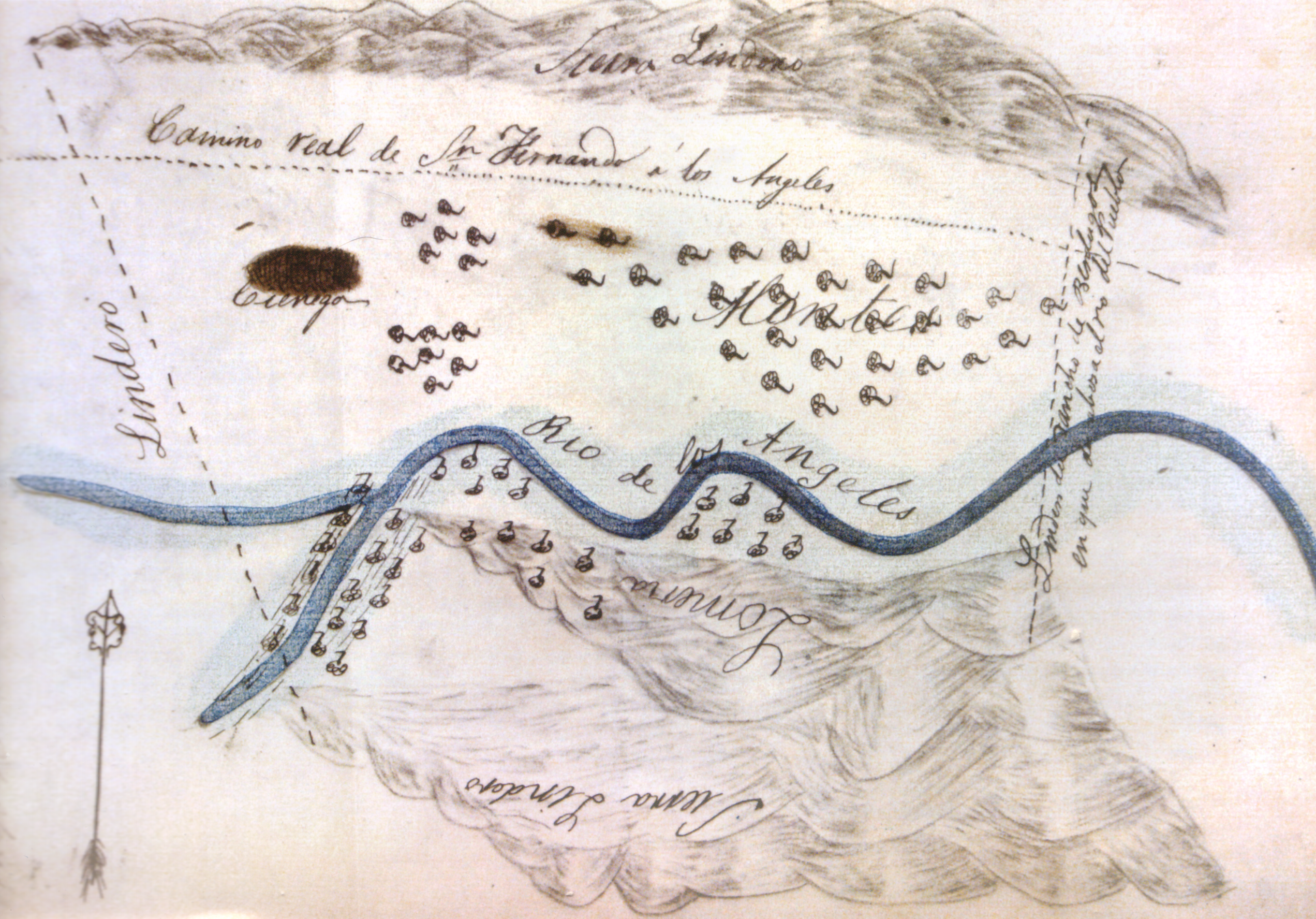
 Sketch map or diseño of Rancho Providencia, 1840s.
It was not until the Mexican era (1821–1846) that the titles to the plots of land were granted to individuals. In 1821, Mexico achieved its independence from Spain, and California came under control of the Mexican government. The 1824 Mexican Colony Law established rules for petitioning for land grants in California; and by 1828, the rules for establishing land grants were codified in the Mexican Reglamento (Regulation). The Acts sought to break the monopoly of the missions and also paved the way for additional settlers to California by making land grants easier to obtain. The procedure included a 'diseño' – a hand-drawn topological map - to define the area.[2][3] The Mexican Governors of Alta California gained the power to grant state lands, and many of the Spanish concessions were subsequently patented under Mexican law.
Through the Secularization Act of 1833, the Mexican government repossessed most of the lands provided to the missions by the Spanish crown.[4][5] Secularization was implemented between 1834 and 1836. The government allowed the padres to keep only the church, priest's quarters and priest's garden. A commissioner would oversee the crops and herds, while the land was divided up as communal pasture, a town plot, and individual plots for each Indian family.[6]
The number of Mexican land grants greatly increased after the secularization of the missions in 1834. Although the original intent of the secularization legislation was to have the property divided among former mission Indians, most of the grants were made to influential Californios of Spanish background.[citation needed]
The Mexican grants were provisional. The boundaries had to be officially surveyed and marked. The grantee could not subdivide or rent out the land. The land had to be used and cultivated. A residential house had to be built within a year. Public roads crossing through the property could not be closed. If the provisional conditions were not met, the land grant could be 'denounced' by another party who could claim the land.[citation needed]
American era
The United States (US) declared war against Mexico on May 13, 1846. Action in California began with the Bear Flag Revolt on June 15, 1846. On July 7, 1846, US forces took possession of Monterey, the capital of California, and terminated the authority and jurisdiction of Mexican officials that day.[7] Armed resistance ended in California with the Treaty of Cahuenga signed on January 13, 1847. The Treaty of Guadalupe Hidalgo, ending the war, was signed February 2, 1848 and California became a Territory of the United States. Between 1847–1849, California was run by the U.S. military. A constitutional convention met in Monterey in September 1849, and set up a state government. It operated for 10 months before California was admitted to the Union as the 31st State by Congress, as part of the Compromise of 1850, enacted on September 9, 1850.
California Gold Rush
While the end of the 1840s saw the close of Mexican control over Alta California, this period also marked the beginning of the rancheros’ greatest prosperity. Cattle had been raised primarily for their hides and for the tallow, as there was no market for large quantities of beef. This dramatically changed with the onset of the Gold Rush, as thousands of miners and other fortune seekers flooded into northern California. These newcomers needed meat, and cattle prices soared with demand. The rancheros enjoyed the halcyon days of Hispanic California.[8]
Land claims
The Treaty of Guadalupe Hidalgo provided that the Mexican land grants would be honored. In order to investigate and confirm titles in California, American officials acquired the provincial records of the Spanish and Mexican governments in Monterey.[9][10]
Sponsored by California Senator William M. Gwin,in 1851 the United States Congress passed "An Act to Ascertain and Settle Private Land Claims in the State of California". The Act required all holders of Spanish and Mexican land grants to present their titles for confirmation before the Board of California Land Commissioners.[11] Contrary to the Treaty of Guadalupe Hidalgo, this Act placed the burden of proof of title on landholders.[12] In many cases, the land grants had been made without clearly defining the exact boundaries. Even in cases where the boundaries were more specific, many markers had been destroyed before accurate surveys could be made. Aside from indefinite survey lines, the Land Commission had to determine whether the grantees had fulfilled the requirements of the Mexican colonization laws. While the Land Commission confirmed 604 of the 813 claims it reviewed, most decisions were appealed to US District Court and some to the Supreme Court.[13] The confirmation process required lawyers, translators, and surveyors, and took an average of 17 years (with American Civil War, 1861–1865) to resolve. It proved expensive for landholders to defend their titles through the court system. In many cases, they had to sell their land to pay for defense fees or gave attorneys land in lieu of payment.[14][15]
Land from titles not confirmed became part of the public domain, and available for homesteaders, who could claim up to 160-acre (0.65 km2) plots in accordance with federal homestead law. Rejected land claims resulted in claimants, squatters, and settlers pressing Congress to change the rules. Under the Pre-emption Act of 1841, owners were able to "pre-empt" their portions of the grant, and acquire title for $1.25 an acre up to a maximum of 160 acres (0.65 km2). Beginning with Rancho Suscol in 1863, special acts of Congress were passed that allowed certain claimants to pre-empt their land – without regard to acreage. By 1866 this privilege was extended to all owners of rejected claims.[16][17]
Disintegration
The rancheros became land rich and cash poor, and the burden of attempting to defend their claims was often financially overwhelming. Grantees lost their lands as a result of mortgage default, payment of attorney fees, or payment of other personal debts. Land was also lost as a result of fraud. A sharp decline in cattle prices, the floods of 1861–1862, and droughts of 1863–1864, also forced many of the overextended rancheros to sell their properties to Americans. They often quickly subdivided the land and sold it to new settlers, who began farming individual plots.[18]
A shift in the economic dominance of grain farming over cattle raising was marked by the passage of the California "No-Fence Law" in 1874. This repealed the Trespass Act of 1850, which had required farmers to protect their planted fields from free-ranging cattle. The repeal of the Trespass Act required that ranchers fence stock in, rather than farmers fencing cattle out. The ranchers were faced with either the high expense of fencing large grazing tracts or selling their cattle at ruinous prices.[19][20]
Legacy
The ranchos established land-use patterns that are still recognizable in contemporary California. [21]
List of Ranchos of California
See also
- California hide trade
- History of California to 1899
- Spanish missions in California
- United States Court of Private Land Claims
Notes and references
- ^ Robinson, William Wilcox (1979). Land in California. Ayer Co.. ISBN 978-0-405-11352-9.
- ^ California's Ranching History 1774–1848[dead link]
- ^ Cleland, Robert, 1975, The Cattle on a Thousand Hills: Southern California, 1850–1880, The Huntington Library, San Marino, CA.
- ^ Secularization Of The Missions
- ^ Davis, William Heath. (1929) Seventy-five Years in San Francisco – Missions and their Wealth; Hacendados and Their Property
- ^ The California Missions[dead link]
- ^ More v. Steinbach, U.S. Supreme Court, 127 U.S. 70 (1888)
- ^ "The California Cattle Boom, 1849–1862"
- ^ Beck, Warren A. and Ynez D. Haase, Historical Atlas of California, first edition, p. 24
- ^ "Spanish and Mexican Land Grant Maps, 1855–1875", California State Archives
- ^ Paul W Gates, 1971, The California Land Act of 1851, California Historical Society, Vol. 50, No. 4 (Dec., 1971), pp. 395–430
- ^ "Ranchos of California": Extracts from Cris Perez, Grants of Land in California Made by Spanish or Mexican Authorities
- ^ Report of the Surveyor General 1844–1886
- ^ "Adjudication of Private Land Claims in California, circa 1852–1892"
- ^ Ranchos and the Politics of Land Claims
- ^ Paul W Gates, 2002,Land and Law in California: Essays on Land Policies, Purdue University Press, ISBN 978-1-55753-273-2
- ^ Gordon Morris Bakken, 2000, Law in the western United States, University of Oklahoma Press, ISBN 978-0-8061-3215-0
- ^ Leonard Pitt, Ramon A. Gutierrez, 1999,Decline of the Californios: A Social History of the Spanish-Speaking Californias, 1846–1890, University of California Press,ISBN 978-0-520-21958-8
- ^ Ludeke, John. "The No Fence Law of 1874: Victory for San Joaquin Valley Farmers," California History 59, no. 2 (1980): 98–115.
- ^ "Decimation of the Herds, 1870–1912", San Diego History Journal, January 1965
- ^ David Hornbeck, "Land tenure and rancho expansion in Alta California, 1784–1846", Journal of Historical Geography, Volume 4, Issue 4, October 1978, pp. 371–390
Further reading
- Avina, Rose H. (1976). Spanish and Mexican Land Grants in California, Arno Press, New York.
- Baker, Charles C. (1914). Mexican Land Grants in California, Historical Society of Southern California, Vol IX, pp. 236–243
- Beck, Warren A.; Ynez D. Haase (1974). Historical Atlas of California. University of Oklahoma Press. ISBN 0-8061-1212-3.
- Becker, Robert H. (1969). Designs on the land : disenos of California ranchos and their makers. San Francisco, Book Club of California.
- Beers, Henry Putney (1979). Spanish & Mexican records of the American Southwest : a bibliographical guide to archive and manuscript sources. University of Arizona Press, Tucson.
- Cowan, Robert G. (1956). Ranchos of California. Academy Library Guild, Fresno, Calif..
- Perez, Crisostomo N. (1996). Land Grants in Alta California. Landmark Enterprises. ISBN 978-0-910845-55-7.
- Hayes, Derek (2007). Historical Atlas of California. University of California Press. ISBN 978-0-520-25258-5.
External links
- Alameda County Mexican Land Grants
- Contra Costa County Mexican Land Grants
- Los Angeles County Spanish and Mexican ranchos
- Marin County Mexican Land Grants
- Marin County's Original Ranchos
- Monterey County Mexican Land Grants
- Napa County Mexican Land Grants
- Orange County Spanish and Mexican Ranchos
- San Benito County Mexican Land Grants
- San Francisco County Mexican Land Grants
- San Mateo County Mexican Land Grants
- Santa Barbara County Rancho Map
- Santa Clara County Mexican Land Grants
- Santa Clara Ranchos, Grants, Patents and Maps
- Santa Cruz CountyMexican Land Grants
- Sonoma County Mexican Land Grants
- Sonoma County Mexican Land Grants
- Tehama County Mexican Land Grants
- Ventura County Spanish and Mexican Land Grants
History of California to 1899 Precontact · First explorations · Later explorations · Spanish colonization · Russian colonization · Mexican rule · California Trail · Mexican-American War · U.S. rule · Gold Rush · Civil War
since 1900 By topic By city Los Angeles · Riverside · Sacramento · San Bernardino · San Diego · San Francisco · San Jose
Categories:- California ranchos
- Cultural landscapes
- History of California
- Land law
Wikimedia Foundation. 2010.