- Menlo Park, California
-
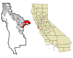
City of Menlo Park — City — Location in San Mateo County and the state of California Coordinates: 37°27′15″N 122°10′43″W / 37.45417°N 122.17861°WCoordinates: 37°27′15″N 122°10′43″W / 37.45417°N 122.17861°W Country  United States
State  California
County San Mateo Incorporated March 23, 1874 Government - Mayor Rich Cline Area[1] - Total 17.415 sq mi (45.105 km2) - Land 9.790 sq mi (25.355 km2) - Water 7.625 sq mi (19.750 km2) 43.79% Elevation 72 ft (22 m) Population (2010 Census) - Total 32,026 - Density 1,839/sq mi (710/km2) Time zone PST (UTC-8) - Summer (DST) PDT (UTC-7) ZIP codes 94025-94029 Area code(s) 650 FIPS code 06-46870 GNIS feature ID 1659108 Website http://www.menlopark.org/ Menlo Park, California is a city at the eastern edge of San Mateo County, in the San Francisco Bay Area of California, in the United States. It is bordered by San Francisco Bay on the north and east; East Palo Alto, Palo Alto, and Stanford to the south; Atherton, North Fair Oaks, and Redwood City to the west. Menlo Park had 32,026 inhabitants according to the 2010 United States Census.[2]
Contents
History
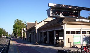
In the nineteenth century two Irish immigrants, Dennis J. Oliver and his brother-in-law D. C. McGlynn, purchased a 1,700-acre (6.9 km2) tract of land on the former Rancho de las Pulgas.[3] In the 1850s they erected a gate with a wooden arch bearing the inscription "Menlo Park" at the entrance to their property (now the intersection of Middle Ave and El Camino Real).[4][5] The word "Menlo" derived from the owners' former home of Menlo in County Galway, Ireland.[3] In 1863, the San Francisco and San Jose Rail Road named a nearby station "Menlo Park" after the sign.[3] The 1867 station building still stands on the platform of the current Caltrain station, used by the local Chamber of Commerce. The town of Menlo Park grew up around this station, becoming a popular home for San Francisco businessmen.[3] A post office arrived in 1870, and the city was incorporated in 1874.[4] The original arch which gave its name to the stations and ultimately the city survived until 1922, when it was destroyed in an automobile accident.[3] The origin of the name of Menlo Park, California (ca 1850)[5] pre-dates any work done by Thomas Edison (ca 1876) in Menlo Park, New Jersey.
The city's library is run by the Peninsula Library System.
Geography
According to the United States Census Bureau, the city has a total area of 17.4 square miles (45 km2), of which 9.8 square miles (25 km2) is land and 7.6 square miles (20 km2) is water. The total area is 43.79% water.
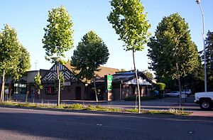
The main street in downtown Menlo Park is Santa Cruz Avenue, with the Menlo Center situated at its intersection with El Camino Real. The Menlo Park Civic Center is bounded by Ravenswood Avenue, Alma Street, Laurel Street and Burgess Drive. It contains the council offices, library, police station and Burgess Park which has various recreational facilities.
Demographics
2010
The 2010 United States Census[6] reported that Menlo Park had a population of 32,026. The population density was 1,839.0 people per square mile (710.0/km²). The racial makeup of Menlo Park was 22,494 (70.2%) White, 1,551 (4.8%) African American, 156 (0.5%) Native American, 3,157 (9.9%) Asian, 454 (1.4%) Pacific Islander, 2,776 (8.7%) from other races, and 1,438 (4.5%) from two or more races. Hispanic or Latino of any race were 5,902 persons (18.4%). Among the Hispanic population, 4,303 (13.4%) are Mexican, 78 (0.2%) are Puerto Rican, 35 (0.1%) are Cuban, and 1,486 (4.6%) are other Hispanic or Latino.
The Census reported that 31,181 people (97.4% of the population) lived in households, 599 (1.9%) lived in non-institutionalized group quarters, and 246 (0.8%) were institutionalized.
There were 12,347 households, out of which 4,112 (33.3%) had children under the age of 18 living in them, 6,163 (49.9%) were opposite-sex married couples living together, 1,039 (8.4%) had a female householder with no husband present, 371 (3.0%) had a male householder with no wife present. There were 642 (5.2%) unmarried opposite-sex partnerships, and 102 (0.8%) same-sex married couples or partnerships. 3,672 households (29.7%) were made up of individuals and 1,371 (11.1%) had someone living alone who was 65 years of age or older. The average household size was 2.53. There were 7,573 families (61.3% of all households); the average family size was 3.20.
The population was spread out with 7,805 people (24.4%) under the age of 18, 1,817 people (5.7%) aged 18 to 24, 9,563 people (29.9%) aged 25 to 44, 8,263 people (25.8%) aged 45 to 64, and 4,578 people (14.3%) who were 65 years of age or older. The median age was 38.7 years. For every 100 females there were 93.7 males. For every 100 females age 18 and over, there were 91.5 males.
There were 13,085 housing units at an average density of 751.4 per square mile (290.1/km²), of which 6,927 (56.1%) were owner-occupied, and 5,420 (43.9%) were occupied by renters. The homeowner vacancy rate was 1.1%; the rental vacancy rate was 5.2%. 18,972 people (59.2% of the population) lived in owner-occupied housing units and 12,209 people (38.1%) lived in rental housing units.
2000
As of the census[7] of 2009, there were 33,690 people, 12,543 households, and 7,248 families residing in the city. The population density was 3,957.1 inhabitants per square mile (1,527.8 /km2). There were 14,026 housing units at an average density of 1,875.4 per square mile (603.9/km²). 64.2% spoke English, 19.5% Spanish, other Indo-European 4.2%, 4.6% Chinese or Mandarin, and other language 0.7%, as their first language from estimate census 2009.
There were 12,543 households out of which 25.8% had children under the age of 18 living with them, 41.5% were married couples living together, 10.8% had a female householder with no husband present, and 45.67% were non-families. 35.1% of all households were made up of individuals and 11.1% had someone living alone who was 65 years of age or older. The average household size was 2.46 and the average family size was 3.15.
In the city the population was spread out with 25.8% under the age of 18, 9.1% from 18 to 24, 31.5% from 25 to 44, 20.4% from 45 to 64, and 14.2% who were 65 years of age or older. The median age was 32 years. For every 100 females there were 94.0 males. For every 100 females age 18 and over, there were 90.6 males.
As of the 2000 estimate census, the median income for a household in the city was $82,609. Males had a median income of $77,766 versus $59,101 for females. The per capita income for the city was $51,341. About 5.9% of families and 7.3% of the population were below the poverty line, including 9.8% of those under age 18 and 8.7% of those over age 64. As of 2009 the median income for a family was $123,251.[8]
Politics
The city is mostly Democratic, with 47% being registered Democrats and 32% being Republicans. In the state legislature Menlo Park is located in the 11th Senate District, represented by Democrat Joe Simitian, and in the 21st Assembly District, represented by Democrat Rich Gordon. Federally, Menlo Park is located in California's 14th congressional district, which has a Cook PVI of D +18[9] and is represented by Democrat Anna Eshoo.
For over twenty years Menlo Park has had a well-defined local partisan split over environmental, traffic, and other issues, between many residents and business interests. This crosses traditional party lines (Republican/Democratic).[citation needed]
Economy
Much of Menlo Park's economy centers around the companies on Sand Hill Road, consisting of venture capital, private equity, financial services, law firms, and other professional service companies and investment vehicles focusing on technology. Geron, Robert Half International, Exponent and SRI International are among the companies based in Menlo Park.
Top employers
According to the City's 2010 Comprehensive Annual Financial Report,[10] the top employers in the city were:
# Employer # of Employees 1 Oracle America 3,114 2 SRI International 1,350 3 Tyco Electronics 1,057 4 Intuit 417 5 Pacific Biosciences 406 6 Safeway 291 7 SHR Hotel 250 8 City of Menlo Park 241 9 United Parcel Service 224 10 Randtron Systems 222 Features
- Home to the Western Region office of the United States Geological Survey.
- Sand Hill Road, location of many Silicon Valley venture capital firms.
- Home to SRI International, formerly Stanford Research Institute.
- Home to the SLAC National Accelerator Laboratory.
- Corporate offices and show gardens of Sunset Magazine.
- Google Inc. was founded here on September 7, 1998
- Adjacent to Menlo College. (Famous alums include Prince Al-Waleed bin Talal.)
- Adjacent to Stanford University and Stanford Shopping Center.
- Home to Saint Patrick Archdiocesan Seminary and University.
- Home to Fuller Northern California
- Home to Menlo Park Presbyterian Church since 1873.
- Home to Geron Corporation, a biotechnology company focusing on telomere and stem cell research.
- Home to the original store of the Round Table Pizza chain.
Historic Landmarks
California Historical Landmarks
- Campsite and terminus point of the de Portolá Expedition from November 6, 1796 through November 10, 1796.
- Home to the oldest continually operating train station in California, making it State Historical Landmark #955.
- Twentieth Century Folk Art Environments, State Historical Landmark #939.
- Camp Fremont, 1917 - 1919. Training camp for the 8th Division, U.S. Army before their planned deployment to France in World War I, and for the 41st Division of the California National Guard. Covering more than 7,000 acres (28 km2) in Menlo Park and Palo Alto, Camp Fremont had 27,000 men and 10,000 animals at its peak. Historical California Posts: Camp Fremont
National Historical Landmarks National Register of Historic Places lists:
- Barron—Latham—Hopkins Gate Lodge #8600195
- Church of the Nativity (Menlo Park, California) #80000855
- Menlo Park Railroad Station #74000556
- Rock Magnetics Laboratory(USGS) #94001647.
- 460 Cotton Street, Home to many Famous People
Notable residents
- Joan Baez, folk singer
- Brandon Crawford, San Francisco Giants shortstop
- Sergey Brin, Google founder
- Lindsey Buckingham, musician
- Henry Cowell, composer
- Jeanne DuPrau, author
- Michael William "Mike" Eggleston, musician/bass
- Nancy Farmer, author
- John Vesely, musician/songwriter
- Chris Gulker, photographer, writer
- Vince Guaraldi, jazz musician
- Ken Kesey, author
- Milton Latham, railroad baron/politician/California Governor (shortest term – five days)
- Fred Moore, political activist
- Stevie Nicks, musician
- Kathleen Rand Reed, anthropologist
- Ariel Rittenhouse, Olympic diver
- Courtney Thorne-Smith, actress
- Isaac Baron, professional poker player
- Thorstein Veblen, sociologist known for "Theory of the Leisure Class"
- Jack Herrick, Founder of wikiHow.
Traffic and parking
Menlo Park suffers from traffic congestion at peak use hours owing to its proximity to Stanford University, and existing traffic demand between Interstate 280 and U.S. Route 101 that exceeds built supply. Much of the city's arterial network consists of two-lane roads.
Since 1963, Menlo Park has had an ordinance that prohibits parking between 2 AM and 5 AM on all residential streets in the city. The city has cited a number of benefits from this rather strict policy including: easier street maintenance, reduced crime, and easier access for nighttime emergencies.[11]
See also
- Menlo Park City School District
- German-American International School
- Menlo Park, New Jersey
- Menlo Park (Pretoria, South Africa)
Notes
- ^ U.S. Census
- ^ "Census 2010: Table 3A — Total Population by Race (Hispanic exclusive) and Hispanic or Latino: 2010" (Excel). California Department of Finance. http://www.dof.ca.gov/research/demographic/state_census_data_center/census_2010/documents/2010Census_Table3A_RedistrictingFile.xls. Retrieved March 22, 2010.
- ^ a b c d e Hoover, Mildred Brooke; Douglas E Kyle (2002). Historic Spots in California (4th edition ed.). Stanford, CA: Stanford University Press. pp. 405. ISBN 0804744831. http://books.google.com/books?id=AYMPR6xAj50C&pg=PA405&vq=%22menlo+park%22&dq=0804744831.
- ^ a b Durham, David L (1998). California's Geographic Names: A Gazetteer of Historic and Modern Names of the State. Clovis, CA: Word Dancer Press. pp. 662. ISBN 1884995144. http://books.google.com/books?id=Yfa0hmE7yocC&pg=PA662&vq=%22menlo+park%22&dq=1884995144.
- ^ a b Stanger, 1963. pg. 109
- ^ All data are derived from the United States Census Bureau reports from the 2010 United States Census, and are accessible on-line here. The data on unmarried partnerships and same-sex married couples are from the Census report DEC_10_SF1_PCT15. All other housing and population data are from Census report DEC_10_DP_DPDP1. Both reports are viewable online or downloadable in a zip file containing a comma-delimited data file. The area data, from which densities are calculated, are available on-line here. Percentage totals may not add to 100% due to rounding. The Census Bureau defines families as a household containing one or more people related to the householder by birth, opposite-sex marriage, or adoption. People living in group quarters are tabulated by the Census Bureau as neither owners nor renters. For further details, see the text files accompanying the data files containing the Census reports mentioned above.
- ^ "American FactFinder". United States Census Bureau. http://factfinder.census.gov. Retrieved 2008-01-31.
- ^ "Best places to live 2008". CNN. http://money.cnn.com/magazines/moneymag/bplive/2008/snapshots/PL0646870.html.
- ^ "Will Gerrymandered Districts Stem the Wave of Voter Unrest?". Campaign Legal Center Blog. http://www.clcblog.org/blog_item-85.html. Retrieved 2008-02-10.
- ^ City of Menlo Park CAFR
- ^ "Parking & Permits". Menlo Park PD website. City of Menlo Park. http://www.ci.menlo-park.ca.us/police/parking.html.
References
- Stanger, Frank M. South from San Francisco: The Life Story of San Mateo County 1963, publisher: San Mateo County Historical Association
External links
- City of Menlo Park
- Official Guide from the Chamber of Commerce
- Menlo Park Library
- Menlo Park Library Foundation
- Menlo Park Historical Association
- Walking Tour of Menlo Park
- San Mateo County Visitors Bureau Guide
Municipalities and communities of San Mateo County, California County seat: Redwood City Cities and towns Atherton | Belmont | Brisbane | Burlingame | Colma | Daly City | East Palo Alto | Foster City | Half Moon Bay | Hillsborough | Menlo Park | Millbrae | Pacifica | Portola Valley | Redwood City | San Bruno | San Carlos | San Mateo | South San Francisco | Woodside
CDPs Unincorporated
communitiesGhost towns Categories:- Menlo Park, California
- Incorporated cities and towns in California
- Cities in San Mateo County, California
- Cities in the San Francisco Bay Area
Wikimedia Foundation. 2010.


