- Pacifica, California
Infobox Settlement
official_name = Pacifica, California
other_name =
native_name =
nickname = P-town
settlement_type =City
motto =
imagesize =
image_caption =
flag_size =
image_
seal_size = 50
image_shield =
shield_size =
image_blank_emblem =
blank_emblem_type =
blank_emblem_size =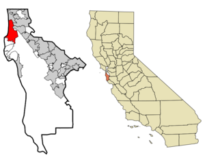
mapsize = 250x200px
map_caption = Location in San Mateo County and the state ofCalifornia
mapsize1 =
map_caption1 =
image_dot_
dot_mapsize =
dot_map_caption =
dot_x =
dot_y =
pushpin_
pushpin_label_position =
pushpin_map_caption =
pushpin_mapsize =
subdivision_type = Country
subdivision_name =United States
subdivision_type1 = State
subdivision_name1 =California
subdivision_type2 = County
subdivision_name2 = San Mateo
subdivision_type3 =
subdivision_name3 =
subdivision_type4 =
subdivision_name4 =
government_footnotes =
government_type =
leader_title =
leader_name =
leader_title1 =
leader_name1 =
leader_title2 =
leader_name2 =
leader_title3 =
leader_name3 =
leader_title4 =
leader_name4 =
established_title =
established_date =
established_title2 =
established_date2 =
established_title3 =
established_date3 =
area_magnitude =
unit_pref =
area_footnotes =
area_total_km2 = 32.8
area_land_km2 = 32.7
area_water_km2 = 0.1
area_total_sq_mi = 12.6
area_land_sq_mi = 12.6
area_water_sq_mi = 0
area_water_percent =
area_urban_km2 =
area_urban_sq_mi =
area_metro_km2 =
area_metro_sq_mi =
area_blank1_title =
area_blank1_km2 =
area_blank1_sq_mi =
population_as_of = 2006
population_footnotes =
population_note =
population_total = 40401
population_density_km2 = 1170.4
population_density_sq_mi = 3046.8
population_metro =
population_density_metro_km2 =
population_density_metro_sq_mi =
population_urban =
population_density_urban_km2 =
population_density_urban_sq_mi =
population_blank1_title =
population_blank1 =
population_density_blank1_km2 =
population_density_blank1_sq_mi =
area_code = 650
timezone = PST
utc_offset = -8
timezone_DST = PDT
utc_offset_DST = -7
latd = 37 |latm = 37 |lats = 22 |latNS = N
longd = 122 |longm = 29 |longs = 8 |longEW = W
elevation_footnotes =
elevation_m = 25
elevation_ft = 82
postal_code_type =ZIP code s
postal_code = 94044-94045
area_code = 650
blank_name = FIPS code
blank_info = 06-54806
blank1_name = GNIS feature ID
blank1_info = 0277613
website =
footnotes =Pacifica is a city in
San Mateo County, California , on the coast of thePacific Ocean betweenSan Francisco and Half Moon Bay. According to City Limits signs in the year 2006, the population was 40,401.Overview
The City of Pacifica is spread along a six mile (10 km) stretch of the north central California coastal beach and hills, nestled in several small valleys spanning between [http://www.nps.gov/goga/clho/swri/ Sweeney Ridge] above on the east,
Montara Mountain to the south, and thePacific Ocean 's sandy beaches and rocky bluffs to the west.Pacifica is well known regionally as a popular
surfing destination withPacifica State Beach /Linda Mar Beach often crowded with surfers. Rockaway Beach is a scenic location and offers recreation, shopping and dining. 2005 marked the opening of the top ranked [http://www.caliskatz.com/v4/skateparks/ratings.asp] [http://www.caliskatz.com/v4/skateparks/pacifica_skatepark.asp Pacifica Skateboard Park] . Pacifica is also a popular [http://pacifica.ca.us/RECREATION/mtn.html mountain biking] destination, with many trails crossing the hillsides that surround the city, including,Pedro Mountain Road , [http://pacifica.ca.us/RECREATION/Sweeney_Ridge.html Sweeney Ridge] , part of the Golden Gate National Recreational Area. Fishermen frequent the local beaches, and thePacifica Pier , catching fish including Striped Bass andSalmon . Many people also enjoyhiking and goingbarefoot in Pacifica, either along the many beaches and bluffs including [http://www.pacificalandtrust.org/mori_pt.html Mori Point] , or on the hillsides includingSan Pedro Valley County Park [http://www.co.sanmateo.ca.us/smc/department/home/0,,5556687_12313317_12345100,00.html] , theSanchez Adobe andMilagra Ridge . For live local theater arts, [http://www.pacificaspindriftplayers.org/ Pacifica Spindrift Players] is consistently popular, in addition to [http://www.pacificaperformances.org/ Pacifica Performances] which regularly serves up both musical presentations and performing arts. Pacifica is also home to the [http://www.parks.sfgov.org/site/recpark_page.asp?id=1863#sharp Sharp Park Golf Course] [http://www.sharpparkgc.com/] designed in 1931 by famous golf architectAlister MacKenzie . The world classbromeliad nursery, [http://shelldance.com Shelldance] is located just off Highway 1 in Pacifica, adjacent to the Sweeney Ridge hiking trailhead.Neighborhoods
Pacifica is divided into roughly twelve distinct neighborhoods from north to south:
#Fairmont
#Westview (Pacific Highlands)
#Pacific Manor (Manor) [http://www.californiacoastline.org/cgi-bin/image.cgi?]
#Edgemar
#Sharp Park [http://www.californiacoastline.org/cgi-bin/image.cgi?]
#Fairway Park [http://www.californiacoastline.org/cgi-bin/image.cgi?]
#Vallemar and Rockaway Beach
#Pedro Point [http://www.californiacoastline.org/cgi-bin/image.cgi?] and Shelter Cove [http://www.californiacoastline.org/cgi-bin/image.cgi?
] in the south west,
#Linda Mar, Linda Mar Valley, (formerly Pedro Valley or San Pedro Valley) in the south.
#Park Pacifica in south east portions of the city (called the Back of the Valley).Government
Governed by a city council of five elected members, with each council seat in turn serving as mayor for a one-year term. A City Manager, City Attorney and City Clerk are appointed and serve in support of the Council to enact the ordinances passed by the Council, which meets biweekly on the second and fourth Tuesdays of the month. [City Of Pacifica website. [http://www.cityofpacifica.org/government/default.asp] ]
Departments
The major City departments, ranked by expenditure [City of Pacifica website. [http://www.cityofpacifica.org/government/budget.asp] ] :
* 32% - Police and Communication Services
* 23% - Fire and Emergency Services
* 6% - Development and Engineering
* 6% - Childcare programs
* 5% - City Attorney
* 5% - Public Works
* 5% - Parks, Beach & Recreation
* 5% - Finance and MISDemographics
As of the
census GR|2 of 2000, there were 38,390 people, 13,994 households, and 9,655 families residing in the city. Thepopulation density was 3,038.9 people per square mile (1,173.6/km²). There were 14,245 housing units at an average density of 1,127.6/sq mi (435.5/km²). The racial makeup of the city was 69.51% White, 3.27% African American, 0.49% Native American, 15.29% Asian, 0.69% Pacific Islander, 4.18% from other races, and 6.58% from two or more races. Hispanic or Latino of any race were 14.61% of the population.There were 13,994 households out of which 32.0% had children under the age of 18 living with them, 53.5% were married couples living together, 11.0% had a female householder with no husband present, and 31.0% were non-families. 21.2% of all households were made up of individuals and 6.4% had someone living alone who was 65 years of age or older. The average household size was 2.73 and the average family size was 3.21.
In the city the population was spread out with 23.2% under the age of 18, 7.7% from 18 to 24, 32.8% from 25 to 44, 26.6% from 45 to 64, and 9.7% who were 65 years of age or older. The median age was 38 years. For every 100 females there were 97.2 males. For every 100 females age 18 and over, there were 95.2 males.
The median
income for a household in the city was $71,737, and the median income for a family was $78,361. Males had a median income of $50,761 versus $40,261 for females. Theper capita income for the city was $30,183. About 1.2% of families and 2.9% of the population were below thepoverty line , including 1.2% of those under age 18 and 4.9% of those age 65 or over.The oldest person to ever live in Pacifica is Rose G. Rosenthal who was born on
April 8 ,1901 , and is still alive today. She is 106 years old.The Reverend Herschell Harkins Memorial pier was constructed in 1973 and was designed to carry sewage piping out to sea. It was closed in 1992 due to corrosion of some of the structure. Since then the pier has been repaired and is a well known fishing spot; on July 8-9, 1995, over 1000 salmon were caught from the pier.
Pacifica opened up a new skate park for its youth in 2005. Here is a virtual tour [http://www.bayareavr.net/fullscreen/?p=skate_n_double]
Climate
The
National Weather Service has maintained a cooperative weather station in Pacifica since November 1, 1983. Based on those records, average January temperatures range from convert|45.8|°F|°C|abbr=on to convert|56.7|°F|°C|abbr=on and average September temperatures range from convert|53.9|°F|°C|abbr=on to convert|71.8|°F|°C|abbr=on. There are an average of 3.0 days with highs of 90 °F (32 °C) or higher and an average of 0.2 day with lows of 32 °F (0 °C) or lower. The highest temperature on record was convert|102|°F|°C|abbr=on on October 5, 1987, and the lowest temperature was convert|23|°F|°C|abbr=on on December 22, 1990. Annual precipitation averages convert|30.29|in|mm and has ranged from convert|15.88|in|mm in 1990 to convert|43.17|in|mm in 1996. The most rainfall in one month was convert|18.05|in|mm in February 1998 and the most rainfall in 24 hours was convert|5.00|in|mm on December 27, 2004. There are an average of 66 days annually with measurable precipitation, most of which falls from November through April. Summer fogs often produce light drizzle in the night and morning hours. Condensation from the fogs also produces "fog drip" from trees overnight. No measurable snowfall has been recorded since records began. [http://www.wrcc.dri.edu/summary/Climsmcca.html/]Politics
In the state legislature Pacifica is located in the 8th Senate District, represented by Democrat
Leland Yee , and in the 19th Assembly District, represented by DemocratGene Mullin . Federally, Pacifica is located inCalifornia's 12th congressional district , which has a Cook PVI of D +22 [cite web | title = Will Gerrymandered Districts Stem the Wave of Voter Unrest? | publisher = Campaign Legal Center Blog | url=http://www.clcblog.org/blog_item-85.html | accessdate = 2008-02-10] and is represented by DemocratJackie Speier .Media
The local newspaper the
Pacifica Tribune [http://www.pacificatribune.com] is published weekly, and originated as the Coastside Tribune early in the Twentieth century. The Tribune was locally owned until its purchase by theANG Newspapers in 1999 [PR Newswire [http://pqasb.pqarchiver.com/prnewswire/access/47266470.html?dids=47266470:47266470&FMT=ABS&FMTS=ABS:FT&date=Dec+16%2C+1999&author=&pub=PR+Newswire&desc=ANG+Newspapers+to+Buy+Milpitas+Post+Newspapers%2C+Inc.&pqatl=google] ] . AUsenet news server group [http://groups.google.com/group/Pacifica-L?hl=en Pacifica-L] has covering local politics, local news and other Pacifica related topics since 1994. The blog [http://pacificariptide.com/ Pacifica Riptide] also actively covers local Pacifica news.[http://www.pct26.com/ Pacifica Community Television] , Pacifica's
Emmy Award winning local cable channel 26, has continuously operated for 30 years featuring community based television. Especially popular are the broadcasts of local governmental meetings plus education and entertainment programming including The Bruce Latimir Show, Ian Butler's Laugh Locally, Foot Prints of Pacifica and Down To Earth by Mel Zucker.-In 1987, Jon Sullberg produced and Directed the documentary film "Unknown Pacifica". Unknown Pacifica is a story told by the people who lived there and were part of or witnessed: rum running, speakeasies, houses of prostitution, distilleries and other vices of the times.
History
Pacifica was incorporated in 1957, relatively recently in history of
San Mateo County , as the union of nine previously separate, unincorporated communities, including Edgemar, Sharp Park, Pacific Manor (or just Manor), Vallemar, Rockaway Beach, Pedro Point, and San Pedro Valley, stops on the short livedOcean Shore Railroad . But Pacifica is also the location of the oldest European history of San Mateo County, [http://www.hallman.org/pacifica/portola.html discovered] byGaspar de Portolà October 31, 1769, and is home of the Sánchez Adobe originating in 1842 and of the San Pedro Valley Mission Outpost (1786-1793) ofMission Dolores . Prehistorically, Pacifica was home to two significantOhlone Indian villages including Pruristac located atSan Pedro Creek near present day Adobe Drive andTimigtac onCalera Creek in the Rockaway Beach neighborhood.School Programs
The elementary and middle school program, known as [http://www.pacificasd.org/ Pacifica School District] , (formerly the Laguna Salada School District), consists of Vallemar, Cabrillo, Ingrid B. Lacy, Sunset Ridge, Ortega, Ingrid B. Lacy, Linda Mar and Ocean Shore schools, and also a home schooling program. The administration office is located at 375 Reina del Mar Avenue, adjacent to Vallemar School. Each school enrolls about 550-600 students.
Pacifica has one private high school and two public high schools which are part of the
Jefferson Union High School District .Oceana High School in the central part of the city while Terra Nova High School andAlma Heights Christian Academy are in the south. Many students in the northern part of Pacifica attend Jefferson High School orWestmoor High School nearby in adjacentDaly City . Oceana's teaching paradigm is geared toward longer classes, senior exhibitions, and mandated community service. Much larger Terra Nova is a traditional institution.Alma Heights Christian Academy is a private K-12 school located 5 minutes from popular Linda Mar Beach.Notable People
*
Robert Dollar , at one point ranked the 88th most wealthy man in the world. Famous for establishing the Dollaradio radio broadcasting site in 1926 near present day Mussel Rock in Pacifica.
*United States CongressmanPete McCloskey . Born in Loma Linda, his family home, built in 1908 by his grandfather Henry McCloskey, is the Sharp Park district landmark known as the [http://www.halfmoonbaymemories.com/category/paul-pete-mccloskey McCloskey Castle] .
*NFL football player of 14 yearsKevin Gogan .
*Poet,Geri Doran .
*Ruth Atkinson , cartoonist.
*Steve Leialoha , a comic book artist.
*Keith Hernandez , Major League Baseball first baseman for the St. Louis Cardinals and New York Mets; attendedTerra Nova High School before transferring to nearbyCapuchino High School . [ [http://findarticles.com/p/articles/mi_qn4176/is_20070822/ai_n19475875 Royals' coach McClure pride of County baseball] , "Oakland Tribune ",August 22 ,2007 . "McClure and Hernandez played together at Terra Nova High before Hernandez transferred to Capuchino."]
*Alan Gordon , a comic book artist.
*Water skiing champion, [http://www.waterskihalloffame.com/pages/Bios/Mike%20Avila.htm Mike Avila] .
*ActorMel Stewart , most famous for playing a character in the television show "All in the Family ".
*Kevin Kelly, editor, founding executive editor of "Wired" magazine, and a former editor/publisher of the "Whole Earth Catalog ".*
Mike Lockwood , professional wrestler with the stage name "Crash Holly".
*Miami Beach based Real Estate Developer,R. Donahue Peebles purchased the controversial Quarry property in 2005.
*Rob Schneider an Actor/comedian, grew up in Pacifica, graduating from Terra Nova High School in 1982. He supports Pacifica music students through [http://www.robschneidermusicfoundation.org/ The Rob Schneider Music Foundation] .
*Oryan Hart ,owner and CEO of One of the most successful advertising and management companies in San Francisco.
*Jef Raskin , the computer interface expert who launched the Macintosh project for Apple Computer.
*Mary Robinson , former President of theRepublic of Ireland andUnited Nations High Commissioner for Human Rights , lived in Pacifica in the 1960s as an exchange student.
*ZZ Packer , an award-winning African-American author, currently lives in Pacifica.
*Greg Reynolds , in the 2008 season Major League Baseball right-handed starting pitcher, for theColorado Rockies .Minor history
*The final scene of the movie "
Harold and Maude ", where Harold drives a car off a cliff, was filmed at Mori Point in Pacifica.
*The house in the novel "House of Sand and Fog " is set in an unnamed coastal town, but the movie scouted Pacifica locations and then rebuilt them in Southern California for the actual filming. The scenes in the movie resemble older parts of Vallemar or Sharp Park near the McCloskey Castle.
*Pacifica is also home to the onlyTaco Bell restaurant (which was an A&W until the early 1980s) located directly on a beach (Pacifica State Beach ); this Taco Bell was rated #9 on TheTravel Channel 's [http://travel.discovery.com/ideas/food-wine/fast-food/fast-food_03.html World Best Fast Food Stops] .
* In 1971, Pacifica gained worldwide attention as the popular St. Peter's Catholic priest, Father Bob Duryea, was excommunicated, after a defiant confrontation with the church, for being married [http://www.time.com/time/magazine/article/0,9171,902904-1,00.html] .External links
* [http://www.cityofpacifica.org City of Pacifica Home Page]
* [http://www.pacificahistory.org/ Pacifica Historical Society]
* [http://pacifica.ca.us/CITYHALL/agenda.html City of Pacifica Commissions, Committees, and City Council meeting agendas]
* [http://www.smcl.org Pacifica Public Libraries (Sharp Park and Sanchez) - branches of the San Mateo County Library]
* [http://www.dmoz.org/Regional/North_America/United_States/California/Localities/P/Pacifica/ Open Directory Project, Pacifica links]Notes
Geographic Location (8-way)
Centre = Pacifica, California
North = Daly City
Northeast = Colma
East = South San Francisco
San Bruno
Southeast =Montara Mountain
South = Montara
Southwest =
West =Pacific Ocean
Northwest =


Wikimedia Foundation. 2010.