- Menlo Park (Caltrain station)
-
Menlo Park Station
Caltrain Commuter rail station
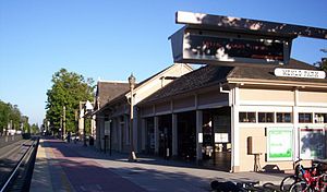
North Face of Train StationStation statistics Address 1120 Merrill Street
Menlo Park, CA 94025Lines Caltrain
Local serviceLimited-stop serviceParking Available Bicycle facilities Lockers available Other information Opened 1867 Accessible 
Owned by Peninsula Corridor Joint Powers Board Fare zone 3 Traffic Passengers (2011) 3,672[1]  6.7%
6.7%Services Preceding station Caltrain Following station toward 4th & KingLocal service toward Tamientoward 4th & KingLimited-stop service toward Tamien
Gilroy during peak hoursMenlo Park Railroad StationLocation: 1100 Merrill Street,
Menlo Park, CaliforniaCoordinates: 37°27′17″N 122°10′51″W / 37.45472°N 122.18083°W Area: less than one acre Built: 1867 Architectural style: Late 19th And Early 20th Century American Movements, Other, Stick-Style Governing body: Private NRHP Reference#: 74000556[2] Added to NRHP: October 1, 1974 Menlo Park Station is a Caltrain station located in Menlo Park, California. The station was originally built in 1867 by the San Francisco and San Jose Railroad and acquired by the Southern Pacific Railroad. During the 1890s Southern Pacific added Victorian Ornamentation to the depot in order to make it appear more attractive to students and visitors to Stanford University. The station was added to the National Register of Historic Places in 1974.[3]
Contents
Station amenities
- Caltrain ticket machines
- 8-Ride ticket validators
Gallery
References
- ^ [1]
- ^ "National Register Information System". National Register of Historic Places. National Park Service. 2010-07-09. http://nrhp.focus.nps.gov/natreg/docs/All_Data.html.
- ^ San Mateo County Listings on the National Register of Historic Places (Building #74000556)
External links

Management Stations 22nd Street • Atherton • Bayshore • Belmont • Blossom Hill • Broadway • Burlingame • California Avenue • Capitol • College Park • Gilroy • Hayward Park • Hillsdale • Lawrence • Menlo Park • Millbrae • Morgan Hill • Mountain View • Palo Alto • Redwood City • San Antonio • San Bruno • San Carlos • San Jose Diridon • San Martin • San Mateo • San Francisco 4th & King Street • Santa Clara • South San Francisco • Stanford • Sunnyvale • Tamien
Former: Bay Meadows • Castro • Paul AvenueConnecting services San Francisco Municipal Railway • Bay Area Rapid Transit • SamTrans • VTA • Altamont Commuter Express • AC Transit • Amtrak Thruway Motorcoach • Monterey-Salinas Transit • San Benito Transit • Santa Cruz Metro • California Shuttle Bus • Dumbarton Express • Highway 17 Express • SMARTOther U.S. National Register of Historic Places Topics Lists by states Alabama • Alaska • Arizona • Arkansas • California • Colorado • Connecticut • Delaware • Florida • Georgia • Hawaii • Idaho • Illinois • Indiana • Iowa • Kansas • Kentucky • Louisiana • Maine • Maryland • Massachusetts • Michigan • Minnesota • Mississippi • Missouri • Montana • Nebraska • Nevada • New Hampshire • New Jersey • New Mexico • New York • North Carolina • North Dakota • Ohio • Oklahoma • Oregon • Pennsylvania • Rhode Island • South Carolina • South Dakota • Tennessee • Texas • Utah • Vermont • Virginia • Washington • West Virginia • Wisconsin • WyomingLists by territories Lists by associated states Other  Category:National Register of Historic Places •
  Portal:National Register of Historic PlacesCategories:
- Caltrain stations in San Mateo County, California
- History of San Mateo County, California
- Railway stations on the National Register of Historic Places in California
- Railway stations opened in 1867
- Southern Pacific Railroad stations in California
- Menlo Park, California
- California railway station stubs
Wikimedia Foundation. 2010.


