- El Camino Real (California)
-
El Camino Real Royal Road Highway system State highways in California(list • pre-1964)
History • Unconstructed • Deleted • Freeway • Scenic A map produced in 1920 illustrating the route of "El Camino Real" in 1821, along with the 20 Alta California Franciscan missions. The road at this time was merely a horse and mule trail.
El Camino Real (Spanish for The Royal Road, also known as The King's Highway) and sometimes associated with Calle Real usually refers to the 600-mile (966-kilometer) California Mission Trail, connecting the former Alta California's 21 missions (along with a number of support sites), 4 presidios, and several pueblos, stretching from Mission San Diego de Alcalá in San Diego in the south to Mission San Francisco Solano in Sonoma in the north.
In fact, any road under the direct jurisdiction of the Spanish crown and its viceroys was a "camino real." Examples of such roads ran between principal settlements throughout Spain and its colonies such as New Spain. Most caminos reales had names apart from the appended "camino real". Once Mexico won its independence from Spain, no road in Mexico, including California, was a camino real. The name was rarely used after that and was only revived in the American period in connection with the boosterism associated with the Mission Revival movement of the early 20th century.
The route originated in Baja California Sur, Mexico, at the site of Misión San Bruno in San Bruno (the first mission established in Las Californias), though it was only maintained as far south as Loreto.
Contents
History
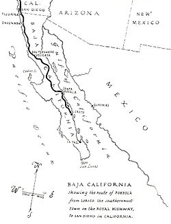 A map of 1920 traces the mission trail in Baja California as it existed in 1769.
Between 1683 and 1834, Spanish missionaries established a series of religious outposts throughout the present-day California and the present-day Baja California and Baja California Sur. To facilitate overland travel, mission settlements were approximately 30 miles (48 kilometers) apart, so that they were separated by one long day's ride on horseback along the 600-mile (966-kilometer) long El Camino Real (Spanish for "The Royal Highway," though often referred to in the later embellished English translation, "The King's Highway"), and also known as the California Mission Trail. Heavy freight movement was practical only via water. Tradition has it that the padres sprinkled mustard seeds along the trail in order to mark it with bright yellow flowers.
In 1912, California began paving a section of the historic route in San Mateo County. Construction of a two-lane concrete highway began in front of the historic Uncle Tom's Cabin, an inn in San Bruno that was built in 1849 and demolished exactly 100 years later. There was little traffic initially and children used the pavement for roller skating until traffic increased. By the late 1920s, California began the first of numerous widening projects of what later became part of U.S. Route 101. Today the route through San Mateo and Santa Clara counties is designated as State Route 82.[1]
An unpaved portion of the original Spanish road has been preserved just east of Mission San Juan Bautista in San Juan Bautista, California.
The road today
Today, several modern highways cover parts of the historic route, though large sections are on city streets (for instance, most of the stretch between San Jose and San Francisco). Its full modern route, as defined by the California State Legislature, is as follows:[2][3]
- Interstate 5, U.S.-Mexico border to Anaheim
- Anaheim Boulevard, Harbor Boulevard, State Route 72 and Whittier Boulevard, Anaheim to Los Angeles
- U.S. Route 101, Los Angeles to San Jose
- State Route 82, San Jose to San Francisco
- Interstate 280, San Francisco
- U.S. Route 101, San Francisco to Novato
- State Route 37, Novato to Sears Point
- State Route 121, Sears Point to Sonoma
- State Route 12, Sonoma
- East Bay route
- State Route 87, Pass through Santa Clara County and Alameda County.
- State Route 92
- State Route 238
- State Route 185, Hayward to Oakland
- State Route 123, Oakland to San Pablo (continued to Martinez)
Some older local roads that parallel these routes also have the name. Many streets throughout California today bear the name of this famous road, often with little factual relation to the original; but Mission Street in San Francisco and its counterpart in Santa Cruz do correspond to the historical route. A surviving, unpaved stretch of the road has been preserved next to the old Spanish mission in San Juan Bautista, California; this road actually follows part of the San Andreas Fault.
Bells
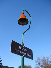 A historical marker situated along El Camino Real.
In 1892, Anna Pitcher of Pasadena, California initiated an effort to preserve the as-yet uncommemorated route of Alta California’s Camino Real, an effort adopted by the California Federation of Women's Clubs in 1902.[4] Modern El Camino Real was one of the first state highways in California. Given the lack of standardized road signs at the time, it was decided to place distinctive bells along the route, hung on supports in the form of an 11-foot (3.4 m) high shepherd's crook, also described as "a Franciscan walking stick." The first of 450 bells were unveiled on August 15, 1906 at the Plaza Church in the Pueblo near Olvera Street in Los Angeles.
The original organization which installed the bells fragmented, and the Automobile Club of Southern California and associated groups cared for the bells from the mid-1920s through 1931. The State took over bell maintenance in 1933. Most of the bells eventually disappeared due to vandalism, theft or simple loss due to the relocation or rerouting of highways and roads. After a reduction in the number of bells to around 80, the State began replacing them, at first with concrete, and later with iron. A design first produced in 1960 by Justin Kramer of Los Angeles was the standard until the California Department of Transportation (Caltrans) began a restoration effort in 1996.
Keith Robinson, Principal Landscape Architect at Caltrans developed an El Camino Real restoration program which resulted in the installation of 555 El Camino Real Bell Markers in 2005. The Bell Marker consists of a 460 mm diameter cast metal bell set atop a 75 mm diameter Schedule 40 pipe column that is attached to a concrete foundation using anchor rods. The original 1906 bell molds were used to fabricate the replacement bells. The replacement and original bells were produced by the California Bell Company, are dated 1769 to 1906, and include a designer's copyright notice.
Historic designations
- California Historical Landmark #784 – El Camino Real ("as Father Serra knew it and helped blaze it" – the segment extending from Mission San Diego de Alcalá to Mission San Francisco de Asís)
See also
- El Camino Real (disambiguation)
- History of California
- Spanish missions in California
- Spanish missions in Baja California
Notes
- ^ San Mateo County Historical Society, San Bruno Herald
- ^ California Streets and Highways Code, Chapter 2, Article 3, Section 635
- ^ California Highways: El Camino Real
- ^ Kurillo, M.; Tuttle, E. (2000). California's El Camino Real and Its Historic Bells. Sunbelt Publications, San Diego, CA. pp. 53–57. ISBN 0-932653-37-5.
References
- Crump, S. (1975). California's Spanish Missions: Their Yesterdays and Todays. Trans-Anglo Books, Del Mar, CA. ISBN 0-87046-028-5.
- Johnson, P., ed. (1964). The California Missions. Lane Book Company, Menlo Park, CA.
- Wright, R. (1950). California's Missions. Hubert A. and Martha H. Lowman, Arroyo Grande, CA.
External links
- Caltrans: El Camino Real Mission Bell Marker Project
- California Bell Company - Original and current manufacturer of the El Camino Real bells
- Trails and Roads: El Camino Real - from the California Highways site
- El Camino Real, California's Coast Route
Categories:- Historic trails and roads in California
- Pre-state history of California
- Historic trails and roads in the United States
- Auto trails in the United States
- California Historical Landmarks
- Spanish missions in California
- New Spain
- Mexican California
- Colonial United States (Spanish)


Wikimedia Foundation. 2010.