- Petaluma River
Geobox|River
name = Petaluma River
native_name =
other_name =
category =river
etymology =Coast Miwok
nickname =
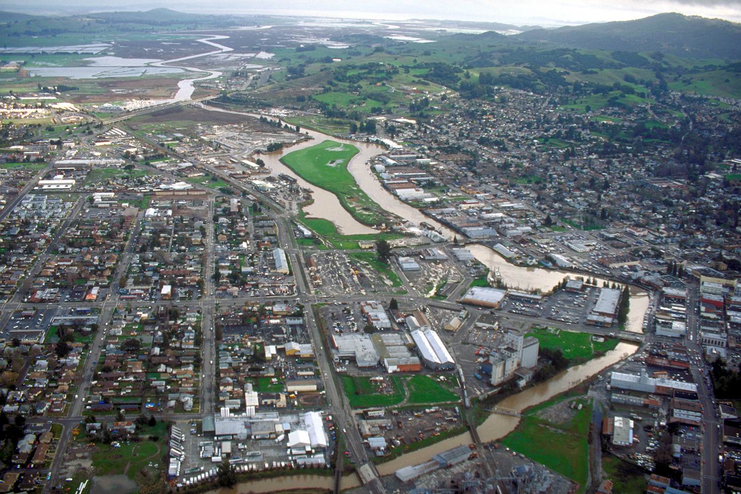
image_caption = The river flowing through Petaluma. View is to the southeast.
country =United States
state =California
region = Sonoma and Marin counties
district =
municipality =
parent =
tributary_left = Lichau Creek
tributary_left1 = Lynch Creek
tributary_left2 = Washington Creek
tributary_left3 = Adobe Creek
tributary_right = San Antonio Creek
city = Petaluma, California
landmark =
river =
source =
source_location = convert|1.5|mi|km|0|lk=on|abbr=on southwest ofCotati, California
source_region = | source_country =
source_elevation_imperial = 332
source_lat_d = 38 | source_lat_m = 18 | source_lat_s = 18 | source_lat_NS = N
source_long_d = 122 | source_long_m = 43 | source_long_s = 3 | source_long_EW = W
source_coordinates_note =Gnis|253749|Petaluma River]
source1 =
source1_location = | source1_region = | source1_country =
source1_elevation_imperial =
source1_lat_d = | source1_lat_m = | source1_lat_s = | source1_lat_NS =
source1_long_d = | source1_long_m = | source1_long_s = | source1_long_EW =
source_confluence =
source_confluence_location = | source_confluence_region = | source_confluence_country =
source_confluence_elevation_imperial =
source_confluence_lat_d = | source_confluence_lat_m = | source_confluence_lat_s = | source_confluence_lat_NS =
source_confluence_long_d = | source_confluence_long_m = | source_confluence_long_s = | source_confluence_long_EW =
mouth =San Pablo Bay
mouth_location = convert|5|mi|km|0|lk=on|abbr=on east ofNovato, California
mouth_region = | mouth_country =
mouth_elevation_imperial = 0
mouth_lat_d = 38 | mouth_lat_m = 6 | mouth_lat_s = 38 | mouth_lat_NS = N
mouth_long_d = 122 | mouth_long_m = 29 | mouth_long_s = 15 | mouth_long_EW = W
mouth_coordinates_note =
length_imperial = 18
length_note =
length_orientation =
width_imperial = | width_orientation =
depth_imperial =
volume_imperial =
watershed_imperial =
discharge_location = Petaluma (USGS gage station 11459000)
discharge_location_note = [cite web|url=http://www.krisweb.com/kris_ems/krisdb/webbuilder/pr_ct12.htm|title=Flow: Monthly Average Petaluma River at Petaluma 1949-1963|accessdate=2007-12-10]
discharge_imperial = 17
discharge_max_imperial = 64
discharge_min_imperial = 0
free = | free_type =
map_caption =
map1 = California Locator Map.png
map1_caption = Location of the mouth of the Petaluma River in California
map1_locator = California
website =
footnotes =The Petaluma River is a river in the
California counties of Sonoma and Marin that becomes a tidal slough near its mouth. It springs from farmlands southwest of Cotati and flows generally southward through Petaluma's old town and convert|10|mi|km|0|lk=on|abbr=on ofmarsh es to end atSan Pablo Bay .The western slopes of
Sonoma Mountain drain to the Petaluma River by way of tributaries such asLichau Creek ,Lynch Creek ,Washington Creek , andAdobe Creek . In the marshes west of Lakeville, the river joins San Antonio Creek, at which point it becomes the boundary between Marin County and Sonoma County. The river flows under State Route 37 at Green Point and enters San Pablo Bay just north of Petaluma Point.While the river's source lies over convert|300|ft|m|-2|lk=on|abbr=on above
sea level , it descends to convert|50|ft|m|0|abbr=on within about convert|0.4|mi|m|-2|abbr=on. The river is fully tidal convert|11|mi|km|0|abbr=on from its mouth, indicating its slight gradient through the marshes below Petaluma. TheUnited States Army Corps of Engineers dredges this section to keep it navigable by gravelbarge s and pleasure craft.Habitat and pollution
The
marsh es provide an important wildlife habitat and fish hatchery. However, since the onset of intensive European immigration in the mid-1850s, thewater quality has diminished, partly due toovergrazing and otheragricultural uses. Pollutants present in the river includenitrate s,phosphate s, petroleumhydrocarbons ,pesticide s andsediment . [ [http://www.coastal.ca.gov/nps/Web/cca_pdf/sfbaypdf/CCA92PetalumaRiver.pdf Petaluma River Water Quality Profile] ] Urban runoff, particularly from the City of Petaluma, addsheavy metals and hydrocarbons to the river. [Kay Ransom, C. Michael Hogan, Ballard George et al., "Environmental Impact Report for the Petaluma General Plan", prepared by Earth Metrics Inc. for the city of Petaluma (1986)] Starting about 1990, material steps were taken to mitigate the pollution. However, continuing population growth makes it difficult to attain the State of California's water quality goals.Bridges
Bridge s span the Petaluma River at the following locations: State Route 37, U.S. 101, Corona Road, Petaluma Boulevard North, and four places in Petaluma (D Street, Payran Street, Washington Street, and Lakeville Street). The longest of these, the 4-lane State Route 37 bridge, is convert|2183|ft|m|abbr=on long and was built in 1958. The oldest bridge, built in 1925, is a convert|114|ft|m|abbr=on concrete triple span carrying two lanes of Petaluma Boulevard North.cite web|url=http://nationalbridges.com/|title=National Bridge Inventory Database]ee also
*
Endangered species
*List of rivers in California
*List of watercourses in the San Francisco Bay Area
*Wetland References
External links
* [http://waterdata.usgs.gov/nwis/uv/?site_no=11459150&PARAmeter_cd=00065,00060,00062,72020 real-time measurements]
Wikimedia Foundation. 2010.