- Cotati, California
-
The City of Cotati — City — 
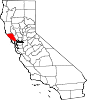
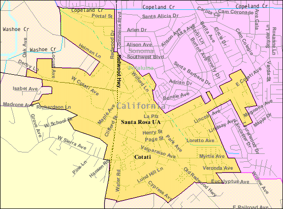
LogoNickname(s): The Hub of Sonoma County[1] Location in Sonoma County and the State of California City boundaries as of 2000
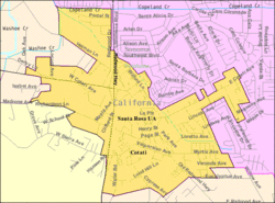
Coordinates: 38°19′40″N 122°42′33″W / 38.32778°N 122.70917°WCoordinates: 38°19′40″N 122°42′33″W / 38.32778°N 122.70917°W Country  United States
State  California
County Sonoma Incorporated July 16, 1963[2] Government – Type Council-manager – Mayor Janet Orchard[3] – Vice Mayor Susan Harvey[3] – City Manager Dianne Thompson Area[4] – Total 1.883 sq mi (4.877 km2) – Land 1.880 sq mi (4.869 km2) – Water 0.003 sq mi (0.008 km2) 0.17% Elevation[5] 112 ft (34 m) Population (2010) – Total 7,265 – Density 3,858.2/sq mi (1,489.7/km2) Demonym Cotatian Time zone PST (UTC-8) – Summer (DST) PDT (UTC-7) ZIP code 94931 Area code(s) 707 FIPS code 06-16560 GNIS feature ID 2410240 Website http://ci.cotati.ca.us/ Cotati (
 /koʊˈtɑːtiː/) is an incorporated city in Sonoma County, California, U.S.A., located about 45 mi (70 km) north of San Francisco in the 101 corridor between Rohnert Park and Petaluma.
Cotati's population as of the 2010 Census was 7,265,[6] making it the smallest incorporated community in Sonoma County.
Like all of Sonoma County, Cotati is included in both the San Francisco Bay Area and the Redwood Empire. Located in the Sonoma Coast AVA, Cotati can also be considered part of the Wine Country. E & J Gallo Winery operates a 400-acre (160 ha) vineyard called Two Rock Vineyard in the hills west of town.[7]
Cotati's hexagonal downtown plaza, one of only two hexagonal town layouts in the United States, is California Historical Landmark number 879.[8] The other U.S. city with a hexagonal layout is Detroit, Michigan.[9]
Contents
Geography and environment
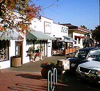 Downtown Cotati, California
According to the United States Census Bureau, the city has a total area of 1.89 sq mi (4.9 km2), 0.53% of which is water.[10]
The city is about 17 mi (27 km) from the Pacific Ocean. It lies entirely in the drainage basin of the Laguna de Santa Rosa. The Petaluma River watershed begins just south of town. To the west is the Stemple Creek watershed. The sources of all three watercourses lie in the hilly area between Stony Point Road and U.S. 101, just west of town.
A gap in the coastal ridges near Petaluma often allows coastal fog to reach Cotati in the summer, giving it a marine climate that is noticeably cooler and less sunny than the "coastal" climates of nearby Santa Rosa and Sebastopol. Cotati averages fewer than 800 hours per growing season in the 70-90 °F (21-32 °C) range.[11]
The soils of the Cotati area are characterized by Quaternary (recent) alluvial materials, explicitly those areas bordering Laguna de Santa Rosa and its tributary Washoe Creek. This material consists largely of stream and valley alluvium as well as artificial fill in certain areas.
Active earthquake faults near Cotati include the Rodgers Creek Fault (5 mi/8 km east) and the Tolay Fault.[12]
To the west of Cotati are wetland habitat for Sebastopol meadowfoam, Pitkin Marsh lily, Showy Indian clover and several other endangered species.[13]
Demographics
Historical populations Census Pop. %± 1970 1,382 — 1980 2,860 106.9% 1990 5,714 99.8% 2000 6,471 13.2% 2010 7,265 12.3% 2010
The 2010 United States Census[14] reported that Cotati had a population of 7,265. The population density was 3,857.8 people per square mile (1,489.5/km²). The racial makeup of Cotati was 5,929 (81.6%) White, 122 (1.7%) African American, 75 (1.0%) Native American, 283 (3.9%) Asian, 30 (0.4%) Pacific Islander, 427 (5.9%) from other races, and 399 (5.5%) from two or more races. Hispanic or Latino of any race were 1,255 persons (17.3%).
The Census reported that 99.9% of the population lived in households and 0.1% lived in non-institutionalized group quarters.
There were 2,978 households, out of which 941 (31.6%) had children under the age of 18 living in them, 1,214 (40.8%) were opposite-sex married couples living together, 399 (13.4%) had a female householder with no husband present, 161 (5.4%) had a male householder with no wife present. There were 259 (8.7%) unmarried opposite-sex partnerships, and 35 (1.2%) same-sex married couples or partnerships. 812 households (27.3%) were made up of individuals and 215 (7.2%) had someone living alone who was 65 years of age or older. The average household size was 2.44. There were 1,774 families (59.6% of all households); the average family size was 2.97.
The population was spread out with 1,591 people (21.9%) under the age of 18, 871 people (12.0%) aged 18 to 24, 2,060 people (28.4%) aged 25 to 44, 2,130 people (29.3%) aged 45 to 64, and 613 people (8.4%) who were 65 years of age or older. The median age was 36.2 years. For every 100 females there were 90.5 males. For every 100 females age 18 and over, there were 86.7 males.
There were 3,143 housing units at an average density of 1,669.0 per square mile (644.4/km²), of which 59.1% were owner-occupied and 40.9% were occupied by renters. The homeowner vacancy rate was 2.0%; the rental vacancy rate was 5.6%. 59.3% of the population lived in owner-occupied housing units and 40.6% lived in rental housing units.
2000
As of the census[10] of 2000, there were 6,471 people, 2,532 households, and 1,607 families residing in the city. The population density was 3,444/sq mi (1,329/km²). There were 2,585 housing units at an average density of 1,376/sq mi (531/km²). The racial makeup of the city was 83.56% White, 2.33% African American, 0.90% Native American, 3.60% Asian, 0.23% Pacific Islander, 4.40% from other races, and 4.98% from two or more races. Hispanic or Latino of any race were 12.52% of the population.
There were 2,532 households out of which 35.3% had children under the age of 18 living with them, 44.8% were married couples living together, 13.1% had a female householder with no husband present, and 36.5% were non-families. 23.9% of all households were made up of individuals and 5.4% had someone living alone who was 65 years of age or older. The average household size was 2.55 and the average family size was 3.05.
The population was distributed with 25.7% under the age of 18, 10.0% from 18 to 24, 35.6% from 25 to 44, 21.7% from 45 to 64, and 7.1% who were 65 years of age or older. The median age was 34 years. For every 100 females there were 95.0 males. For every 100 females age 18 and over, there were 90.3 males. The median income for a household was $52,808, and the median income for a family was $62,419. Males had a median income of $44,771 versus $35,779 for females. The per capita income for the city was $24,206. About 5.3% of families and 8.3% of the population were below the poverty line, including 5.5% of those under age 18 and 3.9% of those over age 64.
In the 2000 Census, 89% of the residents reported that English was their primary spoken language. 11% reported languages other than English, including Spanish (8%), Italian (1%), French (1%), Russian (1%), and Portuguese (less than 1%).[15]
History
The Coast Miwok civilization thrived in the Cotati area since at least 2000 BC, with principal villages built near major streams. Documented villages in the area included Lumen-takala (northeast of present-day Cotati), Payinecha (west of present-day Cotati), and Kotati.[16]
In 1827, an Irishman named John Thomas Reed ventured into Miwok territory and built a cabin near Crane Creek. After the natives burned it, he retreated south to Mill Valley.[17][18]
Rancho Cotate
In July 1844, the Mexican government granted Rancho Cotate (encompassing present-day towns of Cotati, Penngrove and Rohnert Park, and home to Coast Miwok people) to Captain Juan Castaneda, a Mexican military commander from Texas,[19] in payment for his service as a soldier under General Vallejo.[20] The grant took its name from the Coast Miwok village of Kotati.[citation needed] However, a legend arose that Rancho Cotate was named after a Pomo chief named Cotati, and in 1973 the state perpetuated this legend on the historical marker it placed in the plaza.[8]
Rancho Cotate consisted of 17,238.6 acres (6,976.2 ha).[20] Captain Castaneda moved to San Francisco and never developed Rancho Cotate. Because he failed to fulfill the legal requirements of the grant, he lost control of the rancho, which passed to Thomas Larkin and then to Joseph Ruckle. In 1849, Ruckle sold the land to Dr. Thomas Stokes Page, a former resident of Valparaíso, Chile, for $1600.[17][21] Rancho Cotate was recorded in California state records as follows:
"Cotate #65, Sonoma Co., Grant of 4 sq. leagues made in 1844 by Gov. Micheltorena to Juan Casteneda. Confirmed in 1846. Patent for 17,238 acres (69.76 km2) issued in 1858 to Thos. S. Page. In T 5-6N, R 7-8W, MDM."
— California Ranchos: Patented Private Land Grants Listed by County, Shumway 1988:107.
The land holding remained in the Page family for over eighty years. Subject to seasonal flooding from the Laguna de Santa Rosa, the land was used to graze cattle and sheep. In October 1870, the San Francisco and North Pacific Railroad completed the first railroad from Petaluma to Santa Rosa, and a town formed around the wood and water stop called Page's Station, then Cotati.[20][22]
Development of a town
 201 West Sierra as of 2007
Cotati's hexagonal plaza and street grid plan was designed during the 1890s by Newton Smyth as an alternative to the traditional grid. Dr. Thomas Page's barn once stood where the plaza is today, and each of the streets surrounding the plaza is named after one of his sons. In 1892, the Page family created the Cotati Land Company to subdivide their ranch into parcels of five to twenty acres (two to eight hectares).[23] By 1901, good land was selling for $30 to $60 per acre.[24] Page family ownership ended in 1944.[23]
The Cotati area was shaken up by the 1906 San Francisco earthquake. After the quake, Drury Butler reported that "the chimneys were as a rule thrown down". In particular, the Stony Point School at 38°20′36″N 122°44′30″W / 38.3432480°N 122.7416552°W[25] suffered a chimney failure.[26]
The Northwestern Pacific Railroad built the Cotati Depot in 1907. It was located near the East Cotati Avenue crossing, almost 1 mi (1.6 km) east of the plaza.[27] The planned Sonoma-Marin Area Rail Transit station will be in this area.
Prior to 1915, the major north-south roads (Petaluma Hill Road and Stony Point Road) bypassed Cotati. In that year, the state routed the Redwood Highway (part of U.S. Route 101) onto the mostly-unpaved Cotati Boulevard.[28] U.S. 101 passed through the downtown plaza until 1955, when the highway was re-routed further west.[23] U.S. 101 still bisects Cotati, and the former route is called Old Redwood Highway.
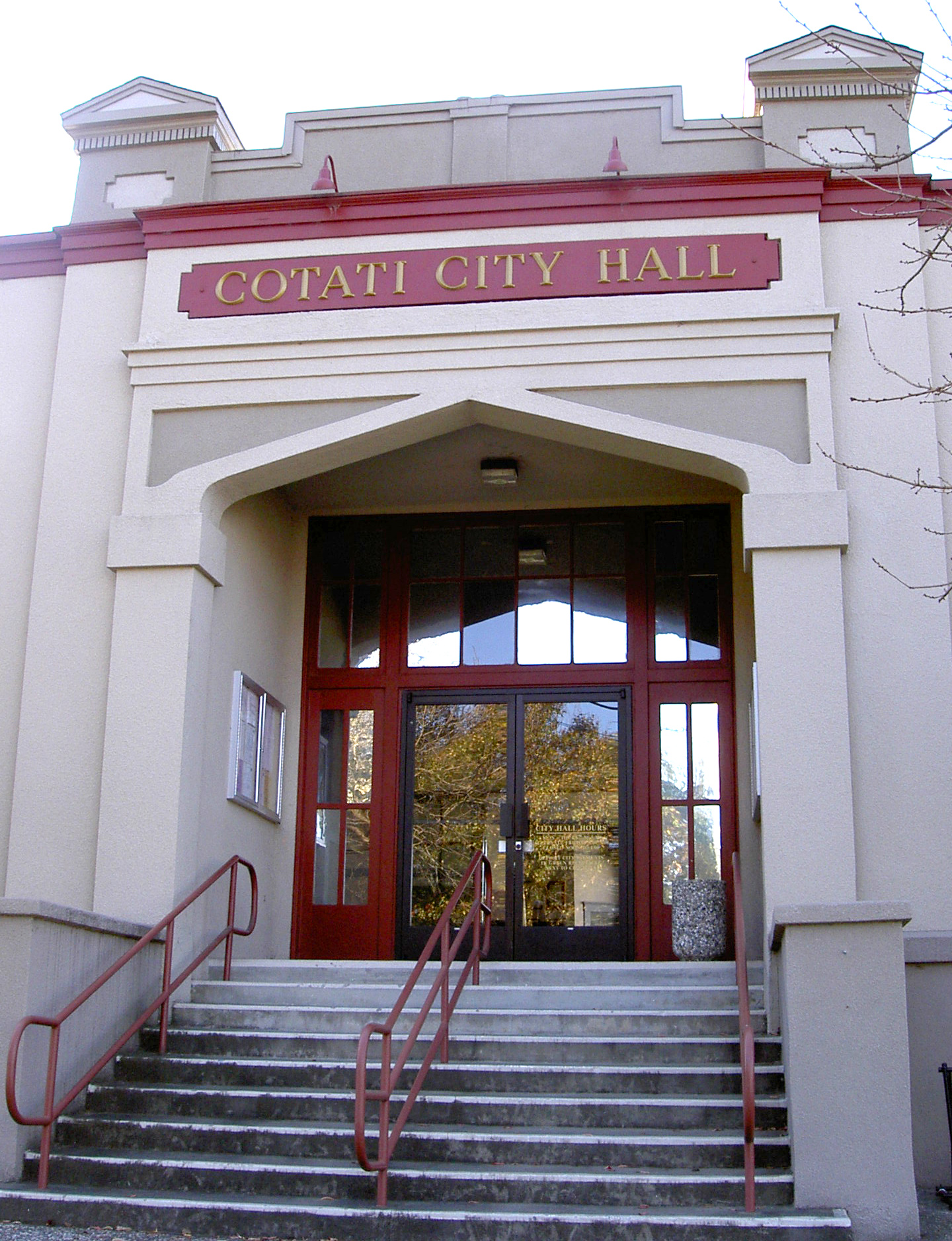
In February 1921, the old schoolhouse at 201 West Sierra burned down. A new school built on the same site opened in 1922.[29] This building has served as City Hall since 1971. The rear of this building housed the Cotati Police Department until September 3, 2003 when the department moved into a new building next door.[30]
The Cotati Speedway, a wooden oval track for automobile racing, was built near the depot around 1921. It was about 1.25 mi (2 km) in circumference. World records were set there, but it failed in its first season and was torn down in 1922.[31]
In 1927, the Cotati Volunteer Fire Department was organized.[31] Since 1993, Cotati has been part of the Rancho Adobe Fire Protection District.
A local weekly newspaper called The Cotatian was established by E. A. Little in 1944 and lasted until 1964.[32] The current local paper is The Community Voice, published in neighboring Penngrove.
Incorporation, growth, and rent control
On July 2, 1963, less than year after the incorporation of the lands north of town to form Rohnert Park, voters approved (by a 284 to 41 margin) incorporation of Cotati as a separate city.[20] After incorporation, the city grew rapidly, due in part to being within commuting range of San Francisco.[33] Between 1965 and 2000, the population increased by more than a factor of four.
In 1979, Cotati voters approved a rent control ordinance for all residential rentals,[34] but in 1995, that ordinance was partly preempted by the passage of AB (Assembly Bill) 1164, known as the Costa/Hawkins Bill.[35][36] At the time, Cotati was one of five cities in California with "strong rent control" laws which included vacancy control. (The other cities were West Hollywood, Santa Monica, Berkeley and East Palo Alto). The Costa/Hawkins bill made it impossible for California municipalities to enforce vacancy control, except in special cases like mobile home parks.[37] When the 1979 ordinance was repealed by Cotati voters in 1998, it was replaced with a more limited ordinance aimed at mobile home parks.[34] At the present time, eight of the nine incorporated areas in Sonoma County have rent control for mobile home parks, the exception being Healdsburg.[38]
In 1990, Cotati citizens voted to impose a limit on future annexation of land by the city.[39] This was followed in 1997 by a ballot measure prohibiting "big-box" retail stores of more than 43,000 square feet (4,000 m2). However, on November 4, 2003, Cotati voters approved (by 1,047 votes to 1,013) Measure B, granting an exception to this ordinance so that a Lowe's Home Improvement Warehouse could be built on the west side of U.S. 101.[40]
Budget crisis
In order to cope with declining revenue, the City instituted a series of budget cuts, starting in 2007. As of August 2009, the City expected to run out of money in its General Fund within a year.[41]
In April 2010, Cotati voters passed Measure A to approve a 1/2 cent sales tax for the next five years. This is expected to stabilize staff and stop the drain on the city's General Fund.
Government
Cotati is governed by a city council with five members, who serve four-year terms. Each year, council members elect a mayor and vice mayor from among themselves. Municipal election are held in November during even-numbered years.
Since 2002, Cotati has been part of California's 3rd State Senate district.[42]
Cotati is in California's 6th State Assembly district.[43]
With respect to the United States House of Representatives, Cotati is part of California's 6th congressional district.
Education
The city is served by Cotati-Rohnert Park Unified School District. Thomas Page Elementary School is the only public school actually located in Cotati. The main high school serving Cotati is Rancho Cotate High School, which is in neighboring Rohnert Park.
Sonoma State University, a public college about 1 mi (1.6 km) east of the city limits, has an influence on Cotati.
Private schools located in Cotati include:
- Cotati-Rohnert Park Co-Op Nursery School
- Rancho Bodega School (grades 6-12)
- Rainbow Bridge Montessori School (Kindergarten only)
- Training Wheels Preschool
Cotati is served by the Sonoma County Library, a public library with branches in Rohnert Park and Petaluma.
Transportation
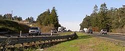 The Cotati Grade on U.S. Route 101
Cotati is served by bus routes operated by Golden Gate Transit (routes 72,[44] 75,[45] and 80[46]) and Sonoma County Transit.
The nearest major airports are San Francisco International Airport and Oakland International Airport. The Santa Rosa airport, which is closer, also offers passenger service.
From the south, U.S. Route 101 North and State Route 116 West approach Cotati on a multilane lane freeway alignment which Caltrans calls the Cotati Grade, with exits at Railroad Avenue and West Sierra Avenue. From the west, State Route 116 East approaches on the two-lane Gravenstein Highway. From the north, U.S. Route 101 South approaches Cotati as a multilane freeway with a single exit at Gravenstein Highway.
Parks and recreation
As of 1995, Cotati had 20.06 acres (8.12 ha) of parks.[47] Cotati parks include:
- Cator Field (along School Street, where the tennis courts are located)
- Helen Putnam Park (along Myrtle Avenue, where the dog park and soccer field are located)
- Kotate Park (playground)
- La Plaza Park (along Old Redwood Highway in the center of town, where the bandstand is located and many annual events are held)
Entertainment
Cotati has numerous annual events, many of them organized by its Community and Environment Commission:
- Pasta Feed and Bingo Night, a fundraising event, usually held in late February or early March
- Farmers' Market, weekly from June to September
- Cotati Jazz Festival, since 1981, usually in mid-June
- Cotati Earth Day, around the end of June
- Kids Day Parade and Festival, for more than 12 years, usually in mid-July
- Accordion Festival, since 1991, usually in mid-August
- Holiday Tree Lighting Ceremony, usually in early December
References
- ^ Draper, p. 8
- ^ "Dates of incorporation". http://www.cacities.org/resource_files/20457.IncorpDateLO.doc. Retrieved 2008-07-11.
- ^ a b "City Council/City of Cotati, California". http://www.ci.cotati.ca.us/sections/council/. Retrieved 2011-01-22.
- ^ U.S. Census
- ^ U.S. Geological Survey Geographic Names Information System: Cotati
- ^ "Census 2010: Table 3A — Total Population by Race (Hispanic exclusive) and Hispanic or Latino: 2010" (Excel). California Department of Finance. http://www.dof.ca.gov/research/demographic/state_census_data_center/census_2010/documents/2010Census_Table3A_RedistrictingFile.xls. Retrieved March 22, 2010.
- ^ "The Falcon and the Farmer". http://winebusiness.com/GrapeGrowing/webarticle.cfm?dataId=37015. Retrieved 2007-12-05.
- ^ a b "Sonoma". California Office of Historic Preservation. http://ohp.parks.ca.gov/default.asp?page_id=21528. Retrieved 2007-11-30.
- ^ Draper, p. 21
- ^ a b "American FactFinder". United States Census Bureau. http://factfinder.census.gov. Retrieved 2008-01-31.
- ^ "Sonoma County Climatic Zones". University of California Cooperative Extension. http://cesonoma.ucdavis.edu/files/27208.pdf. Retrieved 2007-11-30.
- ^ Environmental Impact Report for the La Plaza Specific Plan, Cotati, California (Technical report). Earth Metrics Inc.. 1990.
- ^ C.Michael Hogan, Marc Papineau, Ballard George et al., Environmental Impact Report for the proposed Roblar Road Rock Quarry, Earth Metrics Inc. Report 7673, prepared for Sonoma County and the California State Clearinghouse, September, 1989
- ^ All data are derived from the United States Census Bureau reports from the 2010 United States Census, and are accessible on-line here. The data on unmarried partnerships and same-sex married couples are from the Census report DEC_10_SF1_PCT15. All other housing and population data are from Census report DEC_10_DP_DPDP1. Both reports are viewable online or downloadable in a zip file containing a comma-delimited data file. The area data, from which densities are calculated, are available on-line here. Percentage totals may not add to 100% due to rounding. The Census Bureau defines families as a household containing one or more people related to the householder by birth, opposite-sex marriage, or adoption. People living in group quarters are tabulated by the Census Bureau as neither owners nor renters. For further details, see the text files accompanying the data files containing the Census reports mentioned above.
- ^ MLA Data Center, Census 2000, access date August 2, 2008
- ^ "Miwok Indian Tribe". Access Genealogy. http://www.accessgenealogy.com/native/california/miwokindianhist.htm. Retrieved 2007-11-30.
- ^ a b "History of Cotati: 19th Century". City of Cotati. http://www.ci.cotati.ca.us/sections/about/history2.cfm. Retrieved 2007-11-30.
- ^ Draper, p. 7
- ^ Torrey, John; Dail Miller, Andrew Kratter, Paul Awosika et al. (1989). Environmental Impact Report for the West Gravenstein Specific Plan, City of Cotati (Technical report). EM7526.
- ^ a b c d DeClercq, John (1977). "A History of Rohnert Park "from seed to city"". Rohnert Park Cultural Arts Corporation. http://www.ci.rohnert-park.ca.us/index.aspx?page=458. Retrieved September 26, 2010.
- ^ "RPHS Rancho Cotate". http://www.rphist.org/html/rancho.html. Retrieved 2009-04-03.
- ^ Draper, pp. 22-23.
- ^ a b c "City of Cotati Downtown Specific Plan Draft". http://www.ci.cotati.ca.us/sections/departments/downtown-specific-plan-draft-022006-ch1.pdf. Retrieved 2007-11-30.[dead link]
- ^ Charles Fletcher Lummis, ed (1901). The Land of Sunshine: Magazine of California and the West, Volume XV. The Land of Sunshine Publishing Company. pp. 313.
- ^ U.S. Geological Survey Geographic Names Information System: Stony Point School
- ^ Boatwright, John; Howard Bundock. "Notes on Locating and Assigning Intensities to the Shaking and Damage Descriptions in Lawson (1908)". http://pubs.usgs.gov/of/2005/1135/1906_locations.html. Retrieved 2007-11-30.
- ^ Draper, p. 22
- ^ Draper, p. 53
- ^ Draper, p. 51
- ^ New Police Facility
- ^ a b "History of Cotati: Early 20th Century". City of Cotati. http://www.ci.cotati.ca.us/sections/about/history3.cfm. Retrieved 2007-11-30.
- ^ Draper, pp. 78-79
- ^ Ford, Robert (1975). "Evaluation of Ground Water Resources: Sonoma County". http://www.sonoma.edu/users/n/norwick/Document/Ford/gws1.html.
- ^ a b "Cotati Municipal Code: Title 19 - Housing". http://ordlink.com/codes/cotati/index.htm.
- ^ "AB1164 Bill Text". http://www.leginfo.ca.gov/pub/95-96/bill/asm/ab_1151-1200/ab_1164_bill_950804_chaptered.html. Retrieved 2007-12-01.
- ^ "California Civil Code Sections 1954.50-1954.535". http://www.leginfo.ca.gov/cgi-bin/waisgate?WAISdocID=54466513106+0+0+0&WAISaction=retrieve. Retrieved 2007-12-01.
- ^ Dreier, Peter (May 14, 1997). "Rent Deregulation in California and Massachusetts: Politics, Policy, and Impacts". http://tenant.net/Alerts/Guide/papers/dreier/dreier1.html.
- ^ "Mobile Home Park Rent Control in Sonoma County". http://www.fhosc.org/mobilehome/mobileinfo.html.
- ^ "CotatiToday". http://ci.cotati.ca.us/sections/about/history6.cfm. Retrieved 2008-08-04.
- ^ "Voters approve Solano County growth boundaries". http://goliath.ecnext.com/coms2/gi_0199-1300446/Voters-approve-Solano-County-growth.html. Retrieved September 26, 2010.
- ^ City of Cotati 2008 Water Quality Report, distributed in August 2009
- ^ "2002 Senate District Zip Code Directory". http://www.sen.ca.gov/ftp/SEN/senplan/2002_ZIP_BOOK/SD02_ZIP_CODE_ORDER.PDF. Retrieved 2008-02-01.
- ^ "Map of the 6th Assembly District". http://democrats.assembly.ca.gov/members/global/maps/map06.jpg. Retrieved 2008-02-01.
- ^ "Route 72 Commute Bus Route". http://goldengatetransit.org/schedules/pages/Route_722.html. Retrieved 2008-08-19.
- ^ "Route 75 Commute Bus Route". http://goldengatetransit.org/schedules/pages/Route_752.html. Retrieved 2008-08-19.
- ^ "Route 70/80 Basic Bus Route". http://goldengatetransit.org/schedules/pages/Route_704.html. Retrieved 2008-08-19.
- ^ "City of Cotati Miscellaneous Statistics". http://www.ci.cotati.ca.us/sections/departments/planning-statistics.html.
Further reading
- "Access Genealogy: Indian Tribal records, Miwok Indian Tribe. Retrieved on August 6. 2006. A list of all verified Coastal Miwok villages in the area.
- DeClercq, John H. A History of Rohnert Park "from seed to city" , 1977. Retrieved on August 6, 2006. Includes history of the Cotati-Penngrove region.
- Draper, Prudence and Lloyd Draper, Images of America: Cotati. Arcadia Publishing, 2004. ISBN 0-73852-873-0. Local history with many old photos.
- Shumway, Burgess M., California Ranchos: Patented Private Land Grants Listed by County. San Bernardino, California: The Borgo Press, 1988. ISBN 0-89370-935-2.
External links
- City of Cotati
- Cotati Chamber of Commerce
- Cotati Jazz & Arts Festival
- Cotati Accordion Festival
- Cotati Municipal Code
- Economic Report

Sebastopol Rohnert Park Bloomfield 
Sonoma Mountain  Cotati

Two Rock Penngrove
PetalumaMunicipalities and communities of Sonoma County, California Cities and towns Cloverdale | Cotati | Healdsburg | Petaluma | Rohnert Park | Santa Rosa | Sebastopol | Sonoma | Windsor
CDPs Bloomfield | Bodega | Bodega Bay | Boyes Hot Springs | Carmet | Cazadero | El Verano | Eldridge | Fetters Hot Springs-Agua Caliente | Forestville | Fulton | Geyserville | Glen Ellen | Graton | Guerneville | Jenner | Kenwood | Larkfield-Wikiup | Monte Rio | Occidental | Penngrove | Roseland | Salmon Creek | Sea Ranch | Sereno del Mar | Temelec | Timber Cove | Valley Ford
Unincorporated
communitiesAnnapolis | Asti | Camp Meeker | Duncans Mills | Freestone | Guernewood Park | Lakeville | Mark West | Mark West Springs | Rio Dell | Rio Nido | Schellville | Stewarts Point | Two Rock | Venado | Villa Grande | Vineburg
Indian reservations Categories:- California Historical Landmarks
- Incorporated cities and towns in California
- Cities in Sonoma County, California
- Cities in the San Francisco Bay Area
- Populated places established in 1963


Wikimedia Foundation. 2010.