- Rohnert Park, California
Infobox Settlement
official_name = City of Rohnert Park
other_name =
native_name =
nickname =
settlement_type =City
motto =
imagesize =
image_caption =
flag_size =
image_
seal_size =
image_shield =
shield_size =
image_blank_emblem = RohnertParkLogoEd2662.jpg
blank_emblem_type =Logo
blank_emblem_size = 155x119px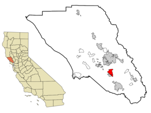
mapsize = 250x200px
map_caption = Location in Sonoma County and the state ofCalifornia
mapsize1 =
map_caption1 =
image_dot_
dot_mapsize =
dot_map_caption =
dot_x =
dot_y =
pushpin_
pushpin_label_position =
pushpin_map_caption =
pushpin_mapsize =
subdivision_type = Country
subdivision_name =United States
subdivision_type1 = State
subdivision_name1 =California
subdivision_type2 = County
subdivision_name2 = Sonoma
subdivision_type3 =
subdivision_name3 =
subdivision_type4 =
subdivision_name4 =
government_footnotes =
government_type = Council-manager
leader_title =Mayor
leader_name = Vicki Vidak-Martinez
leader_title1 =Vice Mayor
leader_name1 = Jake Mackenzie
leader_title2 =
leader_name2 =
leader_title3 =
leader_name3 =
leader_title4 =
leader_name4 =
established_title =
established_date =
established_title2 =
established_date2 =
established_title3 = Incorporated
established_date3 =August 28 ,1962 cite web|url=http://www.cacities.org/resource_files/20457.IncorpDateLO.doc|title=Dates of incorporation|accessdate=2008-07-11]
area_magnitude =
unit_pref =
area_footnotes = GR|2
area_total_km2 = 16.7
area_land_km2 = 16.7
area_water_km2 = 0
area_total_sq_mi = 6.43
area_land_sq_mi = 6.43
area_water_sq_mi = 0
area_water_percent = 0
area_urban_km2 =
area_urban_sq_mi =
area_metro_km2 =
area_metro_sq_mi =
area_blank1_title =
area_blank1_km2 =
area_blank1_sq_mi =
population_as_of = 2000
population_footnotes = GR|2
population_note =
population_total = 42236
population_density_km2 =
population_density_sq_mi = 6564.5
population_metro =
population_density_metro_km2 =
population_density_metro_sq_mi =
population_urban =
population_density_urban_km2 =
population_density_urban_sq_mi =
population_blank1_title =
population_blank1 =
population_density_blank1_km2 =
population_density_blank1_sq_mi =
timezone = PST
utc_offset = -8
timezone_DST = PDT
utc_offset_DST = -7
latd = 38 |latm = 20 |lats = 50 |latNS = N
longd = 122 |longm = 41 |longs = 43 |longEW = W
elevation_footnotes = [gnis|1656263|Rohnert Park]
elevation_m = 32
elevation_ft = 105
postal_code_type =ZIP code s
postal_code = 94926-94928
area_code = 707
blank_name = FIPS code
blank_info = 06-62546
blank1_name = GNIS feature ID
blank1_info = 1656263
website = http://www.ci.rohnert-park.ca.us/
footnotes =Rohnert Park is a city in Sonoma County,
California ,United States , located approximately convert|50|mi|km|-1 north ofSan Francisco . The estimated 2006 population was 41,083. [cite web|url=http://factfinder.census.gov/servlet/SAFFPopulation?_event=Search&_cityTown=Rohnert+Park+city&_sse=on&pctxt=fph&pgsl=010&_submenuId=population_0|title=Rohnert Park city, California|publisher=U.S. Census Bureau|accessdate=2007-12-06] It is an earlyplanned city modeled directly afterLevittown, New York andLevittown, Pennsylvania . Rohnert Park is the sister city of Hashimoto inJapan .Geography
Rohnert Park is located at coor dms|38|20|50|N|122|41|43|W|city (38.347174, -122.695378)GR|1. According to the
United States Census Bureau , it has a total area of 6.43square mile s (16.7km² ).Hydrology
According to the Census Bureau, the city is entirely land. In actuality, there is a small
reservoir calledRoberts Lake at the north end of the city and a number of creeks. Important creeks include theLaguna de Santa Rosa (which forms part of the border with the City of Cotati),Copeland Creek ,Hinebaugh Creek , Crane Creek andFive Creek .All creeks within the city limits have been channelized. Spivock Creek, Coleman Creek, Wilfred Channel, and Labath Channel are artificial channels designed to convey runoff.
Geology
The
Rodgers Creek Fault is an active Fault (geology) influencing earthquake activity in the Rohnert Park area. [ [http://earthquake.usgs.gov/regional/nca/rupture/?id=20010706-0807 USGS, Seismicity in the Rohnert Park, California vicinity] ] The city also experiences earthquakes from theSan Andreas Fault .Biology
Riparian communities within the city are limited by channelization of creekbeds. Vegetation alongside the City's streams primarily consists of grass and sedge species. The Laguna de Santa Rosa contains bands of thick native riparian vegetation, including variouswillow ("Salix" spp.) andalder ("Alnus" spp.) trees. [Earth Metrics, "Environmental Impact Report for the City of Rohnert Park General Plan", C Michael Hogan, Marc Papineau, Ballard George et al., published by the city of Rohnert Park, California and the State of California Environmental Clearinghouse, Sacramento, Ca., Report Number 10351, March 9, 1990]Sudden oak death fungus risks are present in the Rohnert Park area. Research is ongoing at the nearbyFairfield Osborn Preserve . [ [http://www.sonoma.edu/pubs/release/2000/053A.html Sonoma State University research study on Sudden Oak Death Fungus at Fairfield Osborn Preserve (2000)] ]Demographics
As of the
census GR|2 of 2000, there were 42,236 people, 15,503 households, and 9,797 families residing in the city. Thepopulation density was 6,564.5 people per square mile (2,534.6/km²). There were 15,808 housing units at an average density of 2,457/sq mi (949/km²). The racial makeup of the city was 80.28% White, 1.97% African American, 0.78% Native American, 5.58% Asian, 0.42% Pacific Islander, 5.72% from other races, and 5.25% from two or more races. Hispanic or Latino of any race were 13.57% of the population.There were 15,503 households out of which 35.1% had children under the age of 18 living with them, 46.7% were married couples living together, 11.9% had a female householder with no husband present, and 36.8% were non-families. 24.0% of all households were made up of individuals and 7.7% had someone living alone who was 65 years of age or older. The average household size was 2.65 and the average family size was 3.20.
In the city the population was spread out with 25.3% under the age of 18, 14.8% from 18 to 24, 32.0% from 25 to 44, 19.8% from 45 to 64, and 8.1% who were 65 years of age or older. The median age was 32 years. For every 100 females there were 94.1 males. For every 100 females age 18 and over, there were 90.2 males. The median
income for a household in the city was $51,942, and the median income for a family was $61,420. Males had a median income of $41,757 versus $31,149 for females. Theper capita income for the city was $23,035. About 3.2% of families and 8.0% of the population were below thepoverty line , including 4.6% of those under age 18 and 6.3% of those over age 64.Politics
In the state legislature Rohnert Park is located in the 3rd Senate District, represented by Democrat
Carole Migden , and in the 6th Assembly District, represented by DemocratJared Huffman . Federally, Rohnert Park is located inCalifornia's 6th congressional district .History
Originally home of the
Coast Miwok native people [Access Genealogy] , theMexican government granted "Rancho Cotate" to Captain Juan Castenada in July 1844 for his military services in the region. The grant encompassed present-day Penngrove, Cotati and Rohnert Park. "Cotate Rancho is a part of the Vallejo Township which is the plain between Sonoma Mountain and Petaluma CreekSan Pablo Bay , and an east and west line dividing the tract fromSanta Rosa Township." DeClercq, 1977.] Harris, 1980.]"Rancho Cotate" was sold in 1849 to Dr. Thomas S. Page, of Cotati, and eventually broken up and sold off piecemeal to incoming settlers. The town of Rohnert Park was named after the Rohnert family who owned the "Rohnert Seed Farm". In 1929, a successful businessman, Waldo Emerson Rohnert, (born
1869 - died1933 ), a native ofDetroit, Michigan , purchased a large ranch here and minimized flooding in the fields with a crude drainage system but died shortly after. His son, Fred Rohnert, a graduate ofStanford Law School took over the ranch and developed a seed growing business, the "Rohnert Seed Farm", which turned into a major horticultural success for the county.In the year 1956, only four adult residents lived within the district boundaries, but in 1957 with the 101 Freeway newly completed at the Cotati bypass, Rohnert Park began to be built and laid out as a
planned city . In a summer election of 1962, Rohnert Park was incorporated, comprising convert|1325|acre|ha, housing an estimated 2,775 persons, the first town in Sonoma County to incorporate since 1905. The historic neighboring town ofCotati, California voted to incorporate the following year.Education
The
Cotati-Rohnert Park Unified School District serves the city, which is also home toSonoma State University .High schools
Rancho Cotate High School is the main comprehensive high school for both Rohnert Park and Cotati. Technology High School is a small public high school located on theSonoma State University campus.Alternative education consists of:
* Community Day School
* El Camino High School
* Phoenix High School, and
*Independent study .External links
* [http://www.rpcity.org City of Rohnert Park]
* [http://www.crpusd.org/ Cotati-Rohnert Park Unified School District]
* [http://www.sonoma.edu/ Sonoma State University]
* [http://www.pressdemocrat.com/ The Press Democrat Online: News for Rohnert Park and the Surrounding Sonoma Region]
* [http://thecommunityvoice.com/ The Community Voice: Rohnert Park, Cotati and Penngrove]
* [http://thefriendlycity.blogspot.com/ The Friendly City: A blog about life in Rohnert Park, CA.]Notable natives and residents
*Brande RoderickRohnert Park was the home of
Brande Nicole Roderick (born June 13, 1974), who is an American model and actress. She is perhaps best known for her appearances inBaywatch andPlayboy .ee also
*
Film locations in Sonoma County, California Notes
References
* [http://www.accessgenealogy.com/native/california/miwokindianhist.htm "Access Genealogy: Indian Tribal records, Miwok Indian Tribe.] Retrieved on
2006-08-06 . A list of all verified Coastal Miwok villages in the area.
* [http://library.sonoma.edu/regional/subject/rohnert.html DeClercq, John H. "A History of Rohnert Park "from seed to city" ", 1977.] Retrieved on2006-08-06 .
* Harris, Ellen. "Penngrove: A Jigsaw Puzzle of its Past and Present." Penngrove, CA: n.p. [Private Publication] , 1980.Geographic Location
Centre = Rohnert Park
North = Santa Rosa
Northeast = Taylor Mountain
East =Sonoma Mountain
Southeast = Penngrove
South = Cotati
Southwest = Two Rock
West = Bloomfield
Northwest = Sebastopol

Wikimedia Foundation. 2010.