- Laguna de Santa Rosa
Geobox|River
name = Laguna de Santa Rosa
native_name =
other_name =
category =wetland complex
etymology = Spanish
nickname =
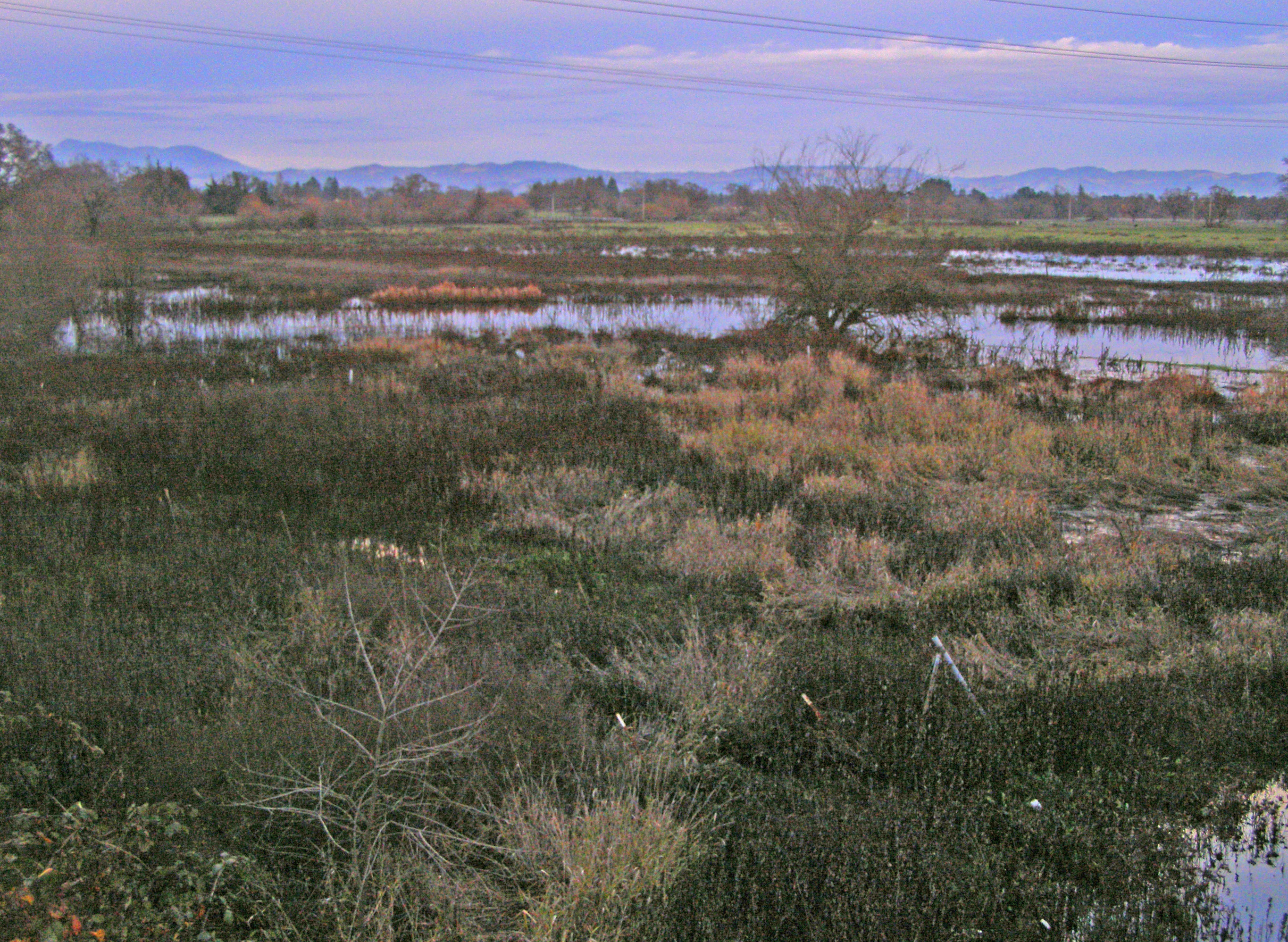
image_caption = Looking northeast across the Laguna de Santa Rosa with theMayacamas Mountains in the background
country =United States
state =California
region = Sonoma County
district =
municipality =
parent =
tributary_right =Santa Rosa Creek
tributary_right1 =Hinebaugh Creek
tributary_right2 =Five Creek
tributary_left =Washoe Creek
tributary_left1 =Blucher Creek
city = Rohnert Park
city1 = Sebastopol
city2 = Cotati
landmark =
river =
source =
source_location = west of Cotati
source_region =California | source_country =
source_elevation_imperial = 260
source_lat_d = 38 | source_lat_m = 19 | source_lat_s = 4 | source_lat_NS = N
source_long_d = 122 | source_long_m = 43 | source_long_s = 21 | source_long_EW = W
source_coordinates_note =Gnis|226766|Laguna de Santa Rosa]
source1 =
source1_location = | source1_region = | source1_country =
source1_elevation_imperial =
source1_lat_d = | source1_lat_m = | source1_lat_s = | source1_lat_NS =
source1_long_d = | source1_long_m = | source1_long_s = | source1_long_EW =
source_confluence =
source_confluence_location = | source_confluence_region = | source_confluence_country =
source_confluence_elevation_imperial =
source_confluence_lat_d = | source_confluence_lat_m = | source_confluence_lat_s = | source_confluence_lat_NS =
source_confluence_long_d = | source_confluence_long_m = | source_confluence_long_s = | source_confluence_long_EW =
mouth =Mark West Creek
mouth_location = east of Forestville
mouth_region =California | mouth_country =
mouth_elevation_imperial = 46
mouth_elevation_note =
mouth_lat_d = 38 | mouth_lat_m = 28 | mouth_lat_s = 12 | mouth_lat_NS = N
mouth_long_d = 122 | mouth_long_m = 50 | mouth_long_s = 27 | mouth_long_EW = W
mouth_coordinates_note =
length_imperial = 14 | length_orientation =
width_imperial = | width_orientation =
depth_imperial =
volume_imperial =
watershed_imperial = 254
discharge_imperial =
discharge_max_imperial =
discharge_min_imperial =
free = | free_type =
map_caption =
map_background =
map_locator =
map_locator_x =
map_locator_y =
website =
footnotes =The Laguna de Santa Rosa is a fourteen mile (22.5 km) long
wetland complex that drains a 254-square mile (658-square kilometer) watershed encompassing most of the Santa Rosa Plain inSonoma County, California , USA.Description
The Laguna, whose principal tributary
stream s rise on the southern slopes of the Sonoma andMayacamas Mountains ,"Santa Rosa Quadrangle", Fifteen minute series, USGS Quadrangle Map, U.S. Government Printing Office, Washington, D.C. (1958)] is the largesttributary ofMark West Creek . The sinuous watercourse and associated wetlands form a significant floodplain during the heavy winter rains, capable of storing over 80,000 acre feet (99,000,000 m³) ofstormwater .Beyond its hydrological significance, the Laguna is Sonoma County's richest area of
wildlife habitat , and the most biologically diverse part of the county, having been called a "national treasure" for its ecological wealth. [Gina Covina, "New Life for the Laguna: Santa Rosa's Wetlands not Going to Waste", Bay Nature, October-December, 2005] A number of rare andendangered species occur in the Laguna, including federally listedthreatened andendangered anadromous salmonid species and three endangered plants that are endemic here. From about 1870 to 1990water quality andbiota deteriorated in the Laguna, due to intensification of urban development ["Laguna de Santa Rosa Drainage Project" [lengthy description, history, land use and natural resources of the Laguna de Santa Rosa] , Sebastopol Times, Sebastopol, Ca., May 15, 1915] and associated agricultural encroachment into the floodplain. In the 1990s the trend began to reverse, but the watercourse is still listed as Impaired under the federalClean Water Act forsediment ,nitrogen ,phosphorus ,temperature , mercury, anddissolved oxygen , rendering it the most impaired water body on the North Coast of California. [ [http://www.swrcb.ca.gov/rwqcb1/programs/tmdl/ldsr/lagunadsr.html State of California regulatory compliance status for Laguna de Santa Rosa] ] Notwithstanding the large historical reduction in resource extent, the Laguna de Santa Rosa is presently the second largest freshwaterwetland in coastalNorthern California and still habitat to over 200species ofbird s,threatened andendangered salmon id species, bald andgolden eagle ,osprey ,mountain lion ,river otter ,coyote ,bobcat ,mink andgray fox .While the Laguna has been heavily impacted by human activities in its watershed over the past century, in recent years a movement has grown to preserve and restore it both for ecological functions such as
habitat values andflood control capacity, and for outdoorrecreation ,education andresearch . Thenonprofit Laguna de Santa Rosa Foundation, founded in 1989, has professionalized and expanded the scope of its programs since 2002, spearheading efforts to protect, restore, and create opportunities for the public to enjoy and learn in the Laguna.Course
The principal source of the Laguna de Santa Rosa lies in the hills on the west side of U.S. Route 101 near
Cotati, California . Its waters descend to the east, crossing under U.S. Route 101 and into Cotati at the West Sierra Avenue interchange. It flows under the Old Redwood Highway just south of Charles Street and joins with a drainage channel near the end of Marsh Way. (Some sources consider this channel to be the main Laguna de Santa Rosa.)From this confluence, the Laguna turns to the northwest and crosses under East Cotati Avenue, providing portions of the boundary between Cotati and Rohnert Park. It crosses back under U.S. Route 101 near Southwest Boulevard and leaves Cotati, continuing northwestward through a series of confluences, with
Copeland Creek ,Washoe Creek ,Hinebaugh Creek , andFive Creek . It crosses Llano Road near the regional water treatment plant, then crosses Todd Road and joinsBlucher Creek . East of Sebastopol, it crosses under State Route 12 at milepost 9.63 and turns to the north. Just south of Guerneville Road, the Santa Rosa Flood Control Channel enters the Laguna, bring water fromSanta Rosa Creek and its tributaries. The Laguna continues north, emptying intoMark West Creek amidst the wetlands east of Forestville.History
Archaeological data in Southern Sonoma County indicates the land surrounding the Laguna de Santa Rosa was under the control of three Pomo tribelets which together, controlled about 350 square miles. These Pomo peoples were called the Konhomtara, the Kataictemi, and the Bitakomtara, whose languages were mutually unintelligible.
The Konhomtara’s territory included “...the area of present day Sebastopol, bounded on the east by the Laguna, on the north by the Russian River, on the west by the summit of the mountains nearest the coast, and on the south by an indeterminate line that extended from the south end of the Laguna to the western border (Stewart, 1943)”.�
The Kataictemi held the land on both sides of the Russian River north of Mark West Creek. Their northern border was about two miles north of present-day Healdsburg, and included the lower portion of Dry Creek.
The Bitakomtara may have been two tribelets, with one located at the head of Santa Rosa Creek, and the other located in Santa Rosa, the latter holding the eastern Laguna lands. Bitakomtara territory occupied the land that was bordered on the north by Mark West Creek, on the West by the Laguna, on the south by “an indefinite line that ran from the top of Sonoma Mountain to the South end of the Laguna”.� and on the east by the summit of the Mayacamas Mountains southward to the peak of Sonoma Mountain (located adjacent to Rohnert Park).
The "South end of the Laguna" was and is as far south as the town of Cotati, approximately 4.5 miles south of Rohnert Park.
Supporting the claim that these three Pomo tribelets were the occupants of the territory is the fact that there are over 80 archaeological sites that have been identified within the Laguna’s historic marshlands as being Pomo. Some of the sites are on the floodplains on the western margin of the Laguna.
The rich wetlands of the Laguna were an important resource for the Pomo people. Control of these resources created a reported tension between the three Pomo tribelets themselves, and territorial borders appear to have been strictly enforced. Permission was needed to pass through each tribelet’s territory. If, for example, the Konhomtara wished to fish on the Russian River, they had to gain permission from the Kataictemi. (Note: The above paragraphs are based on the work of David A. Fredrickson, Ph.D. and Daniel W. Markwyn, Ph.D.)
The ancient Laguna of 2000 BC supported these tribes with abundant fish, fowl and
tule reeds for manufacturing homes andcanoe s. [Laguna de Santa Rosa Foundation library archives, Laguna Foundation, PO Box 7886, Santa Rosa, CA 95407 (2006)] In 1833, the original Mexicanland grant occurred that involved lands of the Laguna watershed. In the year 1870, therailroad arrived with associated channelizations and intensification of agricultural uses. By the 1960s, encroachment of the vast eastern plain was almost complete, and the previously rich run of 1.6 millionanadromous fish had virtually collapsed. By 1989 over 92 percent of the Laguna's historicriparian habitat had been lost, and its water quality had reached critically poor levels.Historically the Laguna was the receiving waters for untreated (and later treated)
sewage from adjacent cities, which eventually joined to participate in a regional sanitation district under the management of the city of Santa Rosa; to some degree due to regulatory action, litigation and pressure from local advocates, the City has become a partner in Laguna restoration by improving the treatment level of this wastewater and minimizing discharge through tertiary wastewater irrigation reuse forhay farming. Though concerns remain relating to compliance and management of this system, Santa Rosa's wastewater treatment and management system is considered to be one of the most progressive in the nation.In that year the Laguna de Santa Rosa Foundation was formed to mobilize public and private resources for preservation and restoration of this natural area. The Foundation has developed education programs, implemented a number of hydrological and ecological restoration projects, and published "Enhancing and Caring for the Laguna", a restoration and management plan for the Laguna watershed, in 2006. Primarily funded by the
California Coastal Conservancy and developed with participation by hundreds of Laguna stakeholder organizations and individuals, the plan serves as a framework for improvement of the Laguna's ecological functions and development oftrail access. The Foundation is now in the process of designing, funding and implementing projects to meet the goals of this plan.Geology
As recently as the
Miocene period, this entire region was submerged below thePacific Ocean . Around 12 million years ago, processes of uplift and volcanic action formed the Mayacamas and Sonoma Mountains to the east and established the maingeomorphic features of the present day landscape. Millions of years of stream erosion carving these mountains led to the rich soils of the Santa Rosa Plain and the Laguna de Santa Rosa drainage that meandered on the vast plain. The western hills are much less pronounced in elevation, and contribute far less to the drainage area of the basin.Soil types within the Laguna are quite complex and vary by reach. Many of the soils of the immediate Laguna area are classified as Clear Lake
clay ; these soils are associated with regions of poor drainage, and are underlain byalluvium andsedimentary rock . ["Soil Survey, Sonoma County, California",U.S. Department of Agriculture ,Soil Conservation Service , Government Printing Office, Washington D.C., May 1972] The surface of these soils is typically dark gray, and soilsacid ity ranges from slight to medium for the first 39 inches (100 cm) of depth; underlying this upper soil layer is a moderatelyalkaline dark gray clay. Deeper, typically below 46 inches (117 cm), is a gray and light brownish gray moderately alkaline clay. Wright loams are also present within the Laguna. The slope of the drainage basin is typically zero to two percent.Hydrology and water quality
The Laguna de Santa Rosa is a principal tributary of
Mark West Creek . Largest among the many tributaries of the Laguna areSanta Rosa Creek ,Copeland Creek ,Hinebaugh Creek ,Five Creek ,Washoe Creek andBlucher Creek . The Laguna consists of a winding ribbon of flow in the dry summer season and a massive floodplain that resembles a series of lakes in the winter storm season. There are numerousvernal pool s on the floodplain that extend for miles to the east, which support many rare andendangered species .With regard to water quality, the Laguna de Santa Rosa is listed as Impaired under the federal
Clean Water Act forsediment ,nitrogen ,phosphorus ,temperature , mercury, anddissolved oxygen , its six such listings being the most of any water body on the North Coast of California.Ecology
The Laguna de Santa Rosa is a complex of habitat types including freshwater
riparian forest andfloodplain s, seasonalwetlands andvernal pool s, uplandvalley oak savanna and freshwatertule marsh . A number of rare andendangered species are found in the Laguna, such as theCalifornia Tiger Salamander "(Ambystoma californiense)",California freshwater shrimp "(Syncaris pacifica)" andSebastopol meadowfoam "(Limnanthes vinculans)". As an element of thePacific Flyway , the Laguna is home to a large variety ofavifauna includingClapper Rail ,Canada Goose "(Branta canadensis)",Turkey Vulture "(Cathartes aura)",Black-necked Stilt "(Himantopus mexicanus)",Burrowing Owl "(Athene cunicularia)",Great Egret "(Casmerodius albus)",Great Blue Heron "(Ardea herodias)" andAmerican Kestrel "(Falco sparverius)". More than 200species ofbirds are known to reside in or feed and rest in the Laguna in the course of migration.Salmonid species listed as threatened or endangered species are known to travel through the Laguna to spawn in its tributaries, includingsteelhead trout "(Oncorhynchus mykiss)" andcoho salmon "(Oncorhynchus kisutch)".tewardship & Land Management
Much of the Laguna's most important habitat is in private hands, and multiple public agencies regulate various aspects of the Laguna's water, lands and natural resources. At the federal level, the U.S. Army Corps of Engineers has played a role in analysis of water quality, especially related to sediment issues, and the
National Marine Fisheries Service of theNational Oceanographic and Atmospheric Administration regulates critical habitat and recovery efforts for threatened and endangered salmonid species. The state of California, through its Department of Fish and Game, has ownership involvement as well as an enforcement role in species protection, while the North Coast Regional Water Quality Control Board is responsible for regulating water quality in the Laguna. Locally, the Sonoma County Water Agency manages areas of the Laguna for flood control, and the City of Santa Rosa's Subregionalwastewater System's main plant is located in the Laguna floodplain and owns and manages adjacent lands for storage and agricultural reuse of treated wastewater as well as for habitat values. The City of Sebastopol also owns lands in the Laguna which it manages as public parkland. In theprivate sector , the Laguna de Santa Rosa Foundation plays an active role in planning, public education, restoration, research and implementation of education programs in the Laguna.Bridges
At least ten bridges span the Laguna as it flows along the heavily populated U.S. Route 101 corridor:cite web|url=http://nationalbridges.com/|title=National Bridge Inventory Database]
* at Old Redwood Highway near Commerce Boulevard, a convert|24|ft|m|0|adj=on concrete culvert built in 1956
* at U.S. Route 101 northbound, a convert|22|ft|m|0|adj=on concrete culvert built in 1956
* at U.S. Route 101 southbound, a convert|22|ft|m|0|adj=on concrete tee beam built in 1919 and reconstructed in 1994
* at Redwood Drive, a convert|22|ft|m|0|adj=on concrete culvert built in 1956 and reconstructed in 2002
* at Llano Road, a convert|179|ft|m|0|adj=on concrete continuous slab built in 1962
* at Todd Road, a convert|152|ft|m|0|adj=on concrete continuous slab built in 1973
* at Stony Point Road, a convert|236|ft|m|0|adj=on concrete continuous slab built in 1960 and reconstructed in 1994
* at State Route 12, convert|220|ft|m|0|adj=on concrete continuous tee beam built in 1921 and reconstructed in 1949
* at Occidental Road, a convert|240|ft|m|0|adj=on concrete continuous slab built in 1990, and
* at Guerneville Road, a convert|446|ft|m|0|adj=on concrete continuous tee beam built in 1957.ee also
*
Coho salmon
*List of watercourses in the San Francisco Bay Area
*Santa Rosa Creek References
External links
* [http://www.lagunafoundation.org/ Laguna de Santa Rosa Foundation official site]
* [http://www.ccwi.org/cm/laguna.htm Community Clean Water Institute Laguna de Santa Rosa water quality monitoring]
Wikimedia Foundation. 2010.