- Downey, California
-
City of Downey — City — Downtown Downey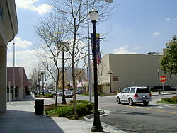
Flag
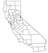
SealLocation of Downey in Los Angeles County, California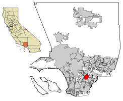
Coordinates: 33°56′17″N 118°07′51″W / 33.93806°N 118.13083°WCoordinates: 33°56′17″N 118°07′51″W / 33.93806°N 118.13083°W Country  United States
State  California
County Los Angeles Founded October 23, 1873 Incorporated December 17, 1956 Government - Type Council-Manager - City Council Mayor Luis H. Marquez
David R. Gafin
Roger Brossmer
Mario Guerra
Fernando Vasquez- City Manager Gerald Caton - Finance Director John Michicoff Area[1] - Total 12.568 sq mi (32.551 km2) - Land 12.408 sq mi (32.137 km2) - Water 0.160 sq mi (0.414 km2) 1.27% Elevation 118 ft (36 m) Population (2010) - Total 111,772 - Rank 11th in Los Angeles County
53rd in California
232nd in the United States- Density 8,893.4/sq mi (3,433.8/km2) Time zone PST (UTC-8) - Summer (DST) PDT (UTC-7) ZIP codes 90239-90242 Area code(s) 562 FIPS code 06-19766 GNIS feature ID 1652698 Website www.downeyca.org Downey is a city located in southeast Los Angeles County, California, United States, 21 km (13 mi) southeast of downtown Los Angeles. The city is best known as the birthplace of the Apollo space program, and is the city where folk singer Karen Carpenter lived and died. As of the 2010 census, the city had a total population of 111,772, up from 107,323 at the 2000 census.
Contents
History
Prior to the arrival of the Spanish in Alta California, the area that now comprises Downey was inhabited by the Tongva ethnic group, which came to be called the Gabrielino by the Spanish. The nearest Tongva settlements appear to have been just north and northeast of present-day Downey, although there is difficulty is locating them very precisely.[2] The villages of Naxaaw’nga and Sehat seem to have been situated near the present-day community of Los Nietos, or perhaps farther west on sites that were lost to floods of the San Gabriel River. Chokiishnga and Huutnga are other Tongva place names that may have referred to villages in the general area north of Downey between the San Gabriel River and Rio Hondo.[3] In all four cases, it is difficult to relate the original location descriptions, based on ranchos and land grants, to more specific sites identifiable by today’s landmarks. Mission San Gabriel Arcangel was initially founded on September 8, 1771, near these concentrations of Tongva population, at a site in the Whittier Narrows on a bluff overlooking the Rio Hondo near the intersection of today’s San Gabriel Blvd and Lincoln Avenue. [4] After five years, flooding forced the relocation of the mission to its present site in San Gabriel.
In 1784, Governor Pedro Fages granted to former soldier Manuel Nieto (1734–1804) the largest of the land concessions made during the Spanish control of California. Its 300,000 acres (1,200 km2) stretched from the Santa Ana River on the east to the Old San Gabriel River (now the Rio Hondo and Los Angeles River) on the west, and from the mission highway (approximately Whittier Boulevard) on the north to the ocean on the south. Its acreage was slightly reduced later at the insistence of Mission San Gabriel on whose lands it infringed. The Spanish concessions, of which 25 were made in California, were unlike the later Mexican land grants in that title was not transferred, but were similar to grazing permits, with the title remaining with the Spanish crown.[5]
The Rancho Los Nietos passed to Manuel Nieto's four children upon his death and remained intact until, in 1833, his heirs petitioned Mexican Governor José Figueroa to partition the property. The northwestern portion of the original rancho, comprising the Downey-Norwalk area, was granted as Rancho Santa Gertrudes to Josefa Cota, the widow of Manuel's son, Antonio Nieto. At approximately 21,000 acres (85 km2), Santa Gertrudes was itself a sizable rancho and contained the old Nietos homestead, which was a center of social life east of the pueblo of Los Angeles.[6] After the Mexican-American war concluded in 1848, many of the Californio ranchos were obtained by affluent Anglo-Americans who were immigrating west under the United States manifest destiny doctrine, and marrying into established Californio Spanish families.
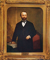 Governor Downey by William F. Cogswell
Unlike most Southern California towns, Downey can claim some of its roots came from Ireland. [7] Downey was founded by and named for the former and youngest ever governor of California, John Gately Downey, who was born in Ireland. Although he was an Irish Democrat, he supported the Republican Lincoln in his efforts to keep the Union intact during the Civil War. He pioneered the modern subdivision with land he acquired between the Rio Hondo and the San Gabriel River, in about 1865. Downey was convinced that oranges would flourish in Southern California, so he imported several varieties, and therefore set in motion what became one of the state's biggest cash crops.[7] In 1935 Downey was described as an "orange-grove town".[8] The Southern Pacific Railroad arrived in 1873, and farmers in the area grew grain, corn, castor beans and fruit until around 1940.
Downey was incorporated in 1956, and instituted a charter form of government in 1964. Suburban homes and factories replaced the farms after World War II. The largest employer was originally Vultee Aircraft, then North American Aviation, (later North American Rockwell, then Rockwell International which was then bought by the Boeing company) whose facilities were the birthplace of the systems for the Apollo space program as well as the Space Shuttle. For over 70 years, Downey's Rockwell NASA plant produced and tested many of the 20th century's greatest aviation, missile, and space endeavors. By the early 1970s, the facilities encompassed some 1,700,000 square feet (160,000 m2) of enclosed area over more than 200 acres. But, by the early 1990s, Downey was brutally hit by cutbacks in the defense budget. Rockwell International, who once had over 30,000 employees, had less than 5,000 in 1992.[citation needed] The seventy year history of airplane and space vehicle manufacturing in Downey came to an end when the Rockwell plant closed in 1999. The former Rockwell plant has been converted to the Downey Landing shopping complex, a Kaiser Permanente hospital, a park, a space museum and Downey Studios.
Near the center of the city lies what was once one of the busiest intersections in the world, the intersection of Lakewood Boulevard (State Route 19) and Firestone Boulevard (former State Route 42). Route 19 was a major thoroughfare between Pasadena and the port at Long Beach, and Route 42 was part of the old Spanish Trail system that connected Los Angeles to San Diego. In the 1960s the town's Downey Records achieved a small notoriety with recordings like The Chantays' surfing instrumental "Pipeline". Downey's two main public high schools are named for Governor Downey and Governor (and later, Chief Justice) Earl Warren. Downey is home to Rancho Los Amigos National Rehabilitation Center, which is the main public rehabilitation hospital for Los Angeles County. Rancho Los Amigos is renowned worldwide for its innovative contributions to the care of spinal cord injuries and post-polio syndrome.[citation needed]
Downey was featured in the 2008 American action comedy film Pineapple Express. Many of the buildings along Florence Ave. can be viewed in a driving scene early in the film.[citation needed]
Geography
Downey is located at 33°56′17″N 118°7′51″W / 33.93806°N 118.13083°W (33.938164, -118.130801).[9]
According to the United States Census Bureau, the city has a total area of 12.6 square miles (33 km2). 12.4 square miles (32 km2) of it is land and 0.2 square miles (0.52 km2) of it (1.27%) is water.
The cities of South Gate and Bell Gardens are adjacent to the west and northwest, Pico Rivera lies to the northeast, Santa Fe Springs and Norwalk to the east, and Paramount and Bellflower are to the south.
Demographics
Historical populations Census Pop. %± 1960 82,505 — 1970 88,573 7.4% 1980 82,602 −6.7% 1990 91,444 10.7% 2000 107,323 17.4% 2010 111,772 4.1% source:[10] 2010
The 2010 United States Census[11] reported that Downey had a population of 111,772. The population density was 8,893.3 people per square mile (3,433.7/km²). The racial makeup of Downey was 63,255 (56.6%) White, 4,329 (3.9%) African American, 820 (0.7%) Native American, 7,804 (7.0%) Asian (2.2% Korean, 2.2% Filipino, 0.6% Indian, 0.5% Chinese, 0.3% Vietnamese, 0.3% Japanese, 0.2% Thai, 0.1% Cambodian, 0.1% Pakistani), 221 (0.2%) Pacific Islander, 30,797 (27.6%) from other races, and 4,546 (4.1%) from two or more races. Hispanic or Latino of any race were 78,996 persons (70.7%); 54.0% of Downey is Mexican, 3.9% Salvadoran, 2.0% Cuban, 2.0% Guatemalan, 1.1% Peruvian, 1.0% Nicaraguan, 0.7% Colombian, 0.7% Puerto Rican, 0.6% Peruvian, 0.5% Honduran, 0.4% Argentinean, and 0.2% Costa Rican.
The Census reported that 111,089 people (99.4% of the population) lived in households, 122 (0.1%) lived in non-institutionalized group quarters, and 561 (0.5%) were institutionalized.
There were 33,936 households, out of which 15,697 (46.3%) had children under the age of 18 living in them, 17,405 (51.3%) were opposite-sex married couples living together, 6,289 (18.5%) had a female householder with no husband present, 2,796 (8.2%) had a male householder with no wife present. There were 2,357 (6.9%) unmarried opposite-sex partnerships, and 225 (0.7%) same-sex married couples or partnerships. 5,721 households (16.9%) were made up of individuals and 2,211 (6.5%) had someone living alone who was 65 years of age or older. The average household size was 3.27. There were 26,490 families (78.1% of all households); the average family size was 3.68.
The population was spread out with 29,972 people (26.8%) under the age of 18, 12,108 people (10.8%) aged 18 to 24, 33,056 people (29.6%) aged 25 to 44, 25,057 people (22.4%) aged 45 to 64, and 11,579 people (10.4%) who were 65 years of age or older. The median age was 33.3 years. For every 100 females there were 94.1 males. For every 100 females age 18 and over, there were 90.4 males.
There were 35,601 housing units at an average density of 2,832.7 per square mile (1,093.7/km²), of which 17,135 (50.5%) were owner-occupied, and 16,801 (49.5%) were occupied by renters. The homeowner vacancy rate was 1.4%; the rental vacancy rate was 4.9%. 59,555 people (53.3% of the population) lived in owner-occupied housing units and 51,534 people (46.1%) lived in rental housing units.
30-40 Homeless (Reference: City of Downey, 3685.pdf; Sec. 3, Consolidated Plan 2010-2015
2000
As of the census[12] of 2000, there were 107,323 people, 33,989 households, and 26,001 families residing in the city. The population density was 8,641.7 inhabitants per square mile (3,336.4/km2). There were 34,759 housing units at an average density of 2,798.8 per square mile (1,080.6/km2). The racial makeup of the city was 53.48% White, 3.75% Black or African American, 0.87% Native American, 7.74% Asian, 0.22% Pacific Islander, 29.05% from other races, and 4.89% from two or more races. 57.85% of the population were Hispanic or Latino of any race.
There were 33,989 households out of which 41.8% had children under the age of 18 living with them, 54.1% were married couples living together, 15.8% had a female householder with no husband present, and 23.5% were non-families. 19.1% of all households were made up of individuals and 8.1% had someone living alone who was 65 years of age or older. The average household size was 3.11 and the average family size was 3.55.
 Typical Downey Gingerbread houses
In the city the population was spread out with 29.2% under the age of 18, 9.8% from 18 to 24, 31.2% from 25 to 44, 18.8% from 45 to 64, and 11.0% who were 65 years of age or older. The median age was 32 years. For every 100 females there were 94.6 males. For every 100 females age 18 and over, there were 89.8 males.
The median income for a household in the city was $46,000 and the median income for a family was $50,017. Males had a median income of $35,991 versus $28,768 for females. The per capita income for the city was $18,197. About 9.3% of families and 11.1% of the population were below the poverty line, including 14.4% of those under age 18 and 7.6% of those age 65 or over.
Downey has the second highest percentage of Cubans and Cuban Americans in the Western United States at 1.96% of the population.[13]
Government and infrastructure
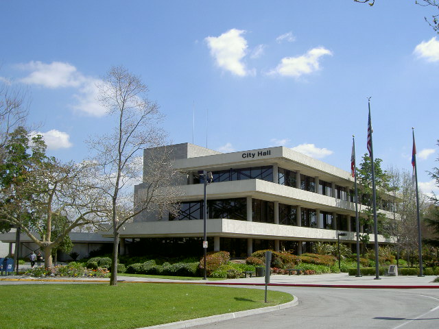
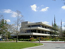 Downey City Hall
In the state legislature Downey is located in the 27th Senate District, represented by Democrat Alan Lowenthal, and in the 50th and 58th Assembly Districts, represented by Democrats Ricardo Lara and Charles M. Calderon respectively. Federally, Downey is located in California's 34th congressional district, which has a Cook PVI of D +23[14] and is represented by Democrat Lucille Roybal-Allard.
The Los Angeles County Department of Health Services operates the Whittier Health Center in Whittier, serving Downey.[15]
The United States Postal Service operates the Downey Post Office at 8111 Firestone Boulevard,[16] the North Downey Post Office at 10409 Lakewood Boulevard,[17] and the South Downey Post Office at 7911 Imperial Highway.[18]
Economy
According to the City's 2009 Comprehensive Annual Financial Report,[19] the top employers in the city are:
# Employer # of Employees 1 Kaiser Permanente 3,000 2 Downey Unified School District 2,000 3 Stonewood Center 1,750 4 Rancho Los Amigos National Rehabilitation Center 1,374 5 Downey Regional Medical Center 955 6 The Coca-Cola Company 920 7 Office of Education, County of Los Angeles 900 8 Lakewood Park Health Center 325 9 Xpedex 250 10 All American Home Center 180 Historic restaurants
McDonald's restaurant
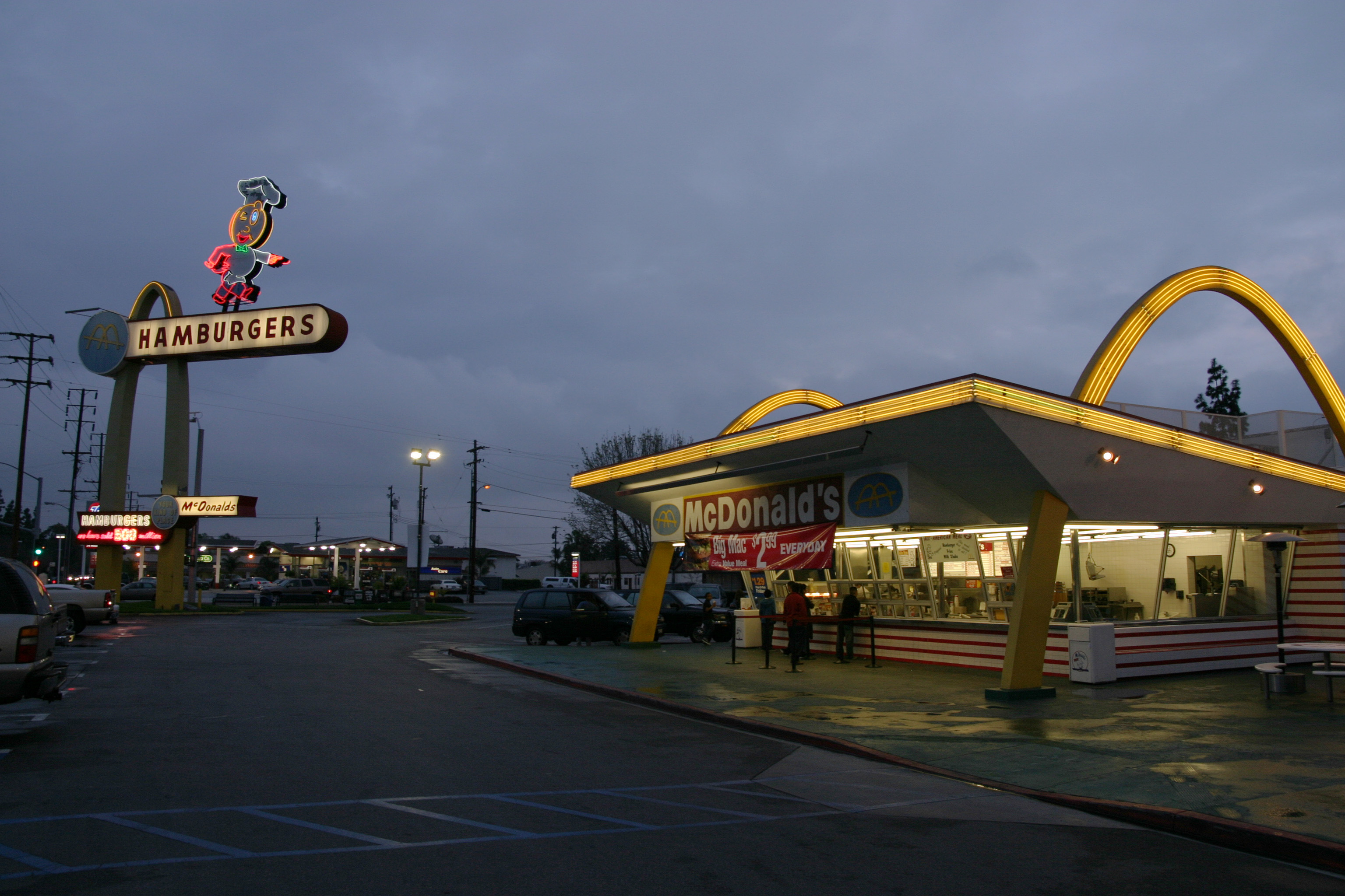
Main article: Oldest McDonald's restaurant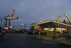 Oldest operating McDonald's restaurant on Lakewood and Florence in Downey, California
The 1953 McDonald's restaurant at 10207 Lakewood Blvd. (at Florence Ave.) was the third McDonald's built and is the oldest surviving McDonald's. It was listed on the National Trust for Historic Preservation's 1994 list of the 11 Most Endangered Historic Places. It was the second restaurant franchised by Richard and Maurice McDonald, prior to the involvement of Ray Kroc in the company, and it still has the two original 30-foot (9.1 m) "Golden arches" and a 60-foot (18 m) animated neon "Speedee" sign.
With low sales, damage from the 1994 Northridge earthquake, and the lack of a drive-up window and indoor seating, the restaurant was closed. However with both the public and preservationists demanding the restaurant be saved, McDonald's spent two years restoring the restaurant and reopened it. Customers today can visit the original restaurant and an adjoining gift shop and museum.
Harvey's/Johnie's Broiler
Johnie's Broiler (originally Harvey's Broiler) was a drive-in restaurant and coffee shop, which has been in movies and sitcoms as well as TV commercials and music videos. Completed in 1958, it is an example of Googie architecture. Johnie's was well known to Southern California locals, many of which drove miles to cruise through its massive lot. In the mid-1960s, renowned author Tom Wolfe immortalized the cruising, car and fashion scene that surrounded Harvey's Broiler at the time; The article, "The Hair Boys," appears in a bestselling 1968 collection of his articles titled, The Pump House Gang. He made drawings of the denizens of Harvey's that appear in a later book, The Purple Decades. The Broiler was a regular commercial and movie location for films such as Heat, What's Love Got to Do with It, Unstrung Heroes, Reality Bites, Can't Hardly Wait, Jawbreaker, as well as a television episode of The X-Files. Lily Tomlin played a waitress who worked at Johnie's in Short Cuts. The last film shot at Johnie's was The Country Bears.[20]
The restaurant was closed in 2001, and a used car dealership leased the property. In January 2007, the leasees of Johnie's started to illegally tear it down.[21] The destruction of the building was halted, with extreme damage to the building, though the sign is intact.[20] Tenants made significant alterations to the dining room without permits, and the City of Downey had to issue several stop work orders and citations.[20]
Bob's Big Boy
In April 2008, Jim Louder, owner of the Bob's Big Boy restaurant in Torrance, California, entered into a long-term lease agreement with the owner of Johnie's Broiler.[22] The restaurant was rebuilt as a Bob's Broiler and incorporated the surviving architectural elements of the old structure into the new restaurant.[23] Bob's Big Boy Broiler is now open for business.[24]
First Taco Bell
Glen Bell opened the first Taco Bell restaurant on March 21, 1962, in Downey. The building, at 7112 Firestone Boulevard, is largely unchanged from its original appearance, but it is no longer a Taco Bell.
Downey Farmers' Market
The Downtown Downey Farmers' Market was approved by the Downey City Council in 2008. It has rapidly blossomed into a community main attraction, with the standard fruit and vegetable stands and a growing number of food booths. It is open every Saturday from 9 AM to 1 PM on Second Street between New St. and La Reina. The market is intended to be a community gathering place, an opportunity to purchase California-grown products, homemade tamales and a vehicle to improve and finance Downtown Downey. [25]
Crime
While reports of robberies, aggravated assaults and petty thefts in Downey dropped in 2008, auto thefts reached a 10-year high. In 2008, 1,231 vehicles were reported stolen in Downey. Other crimes recorded by the FBI Crime Index for the year 2008 include 252 robberies, 172 aggravated assaults, 24 rapes, 711 burglaries and 2,038 acts of larceny/thefts.[26]
Anti-gang activities
In the late 1980s and early 1990s, Downey saw an increase in gang activity. Today there is still gang activity going in the south area of Downey. In response, Downey formed GOOD (Gangs Out Of Downey), a community-based organization that helps encourage young people between the ages of 10-20 to stay away from gangs. GOOD is also responsible for organizing many community events and programs such as various sports, after school care, scholarship programs for at-risk students looking to attend college, and counseling for both young people and their parents. GOOD has kept a close partnership with Downey Police.[27]
Transportation
The city can be conveniently reached by any of four freeways: Interstate 105 with its Metro rail line passes through the southern part of the city, Interstate 5 passes through the northern part, Interstate 605 passes along the eastern side, and Interstate 710 passes just west of the city.
Los Angeles County Metropolitan Transportation Authority (Metro) provides bus services to the city. The city also operates a local bus service called DowneyLINK.
Education
Primary and secondary schools
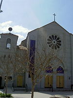 Our Lady of Perpetual Help, serving the Catholic Community of Downey
Downey is within the Downey Unified School District. Public schools include:
- Downey High School
- Alameda Elementary School
- Warren High School (Downey, California) Named after the 14th Chief Justice of the United States Earl Warren.
- Columbus High School
- West Middle School
- East Middle School
- Griffiths Middle School (formerly [North Junior High School])
- Sussman Middle School (formerly [South Middle School])
- Carpenter Elementary School
- Gallatin Elementary School
- Gauldin Elementary School
- Imperial Elementary School
- Lewis Elementary School
- Old River Elementary School
- Price Elementary School
- Rio Hondo Elementary School
- Rio San Gabriel Elementary School
- Unsworth Elementary School
- Ward Elementary School
- Williams Elementary School
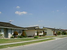
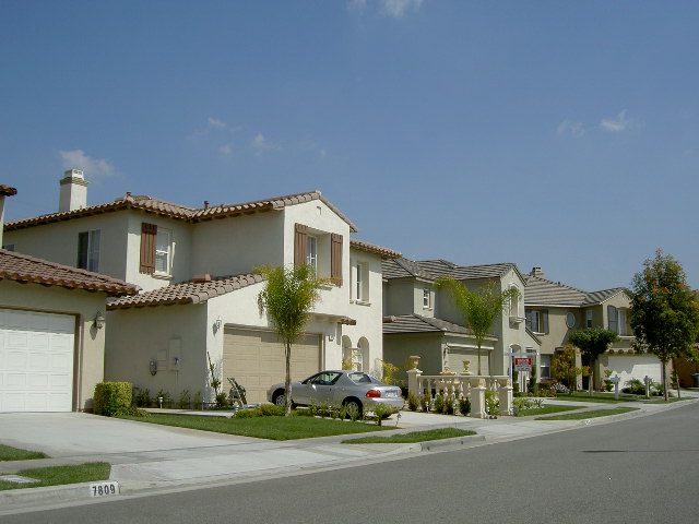
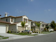 New Homes in Downey
Private schools include:
- Our Lady of Perpetual Help School: pre K-8
- Calvary Chapel, Downey: pre K-12
- St. Matthias High School: 9-12
- Saint Raymond's Catholic School: pre K-8
- Saint Mark's Episcopal School: pre K-8
Public libraries
The Downey City Library serves the city. The first library in Downey was established in 1901 by a women's social club that was founded in 1898. The County of Los Angeles Public Library opened a branch in Downey in September 1915. The county branch moved several times; its final location was in the County Civic Center. In 1958 the Downey City Council voted to establish its own library and withdraw from the county system. The city library services were originally provided out of the back of a bookstore. The city library opened in the former cafeteria of the former Downey Elementary School, then being used as the city hall and police station, on July 1, 1958. A permanent library building was built on December 7, 1959. It had almost 16,000 square feet (1,500 m2) and it was built for $186,200, costing $11.97 per square foot. It was dedicated on December 17 and opened on December 18. In February 1984 an addition of almost 12,000 square feet (1,100 m2) was completed and dedicated.[28]
In addition the headquarters of the County of Los Angeles Public Library are located in Downey.[29]
Notable citizens
- Alanna Ubach, actress, was born in Downey.
- Allison Iraheta, musician and American Idol season eight contestant, raised in Downey.
- Aimee Teegarden, actress (Friday Night Lights) and fashion model
- The brother and sister music duo The Carpenters moved to Downey from New Haven in 1963 with their family. When they hit it big in the 1970s they built two apartment buildings there that still operate today. They stand across the street from each other on 5th St. and are named after their two biggest hits "We've Only Just Begun" and "Close To You". The Carpenter's family house still stands today in Newville Avenue as well. The house can be seen on the cover of their album, Now & Then.
- Rock and country musician Dave Alvin was born and raised in Downey. He formed the early Downey based rockabilly band The Blasters with his brother Phil, and later started a solo career as a country musician. He wrote a song called Downey Girl released on his 2009 album Dave Alvin & The Guilty Women.
- Thrash metal band Dark Angel formed in Downey.
- Surfer and acoustic rock musician Donavon Frankenreiter was born in Downey.
- Dan Henderson, a mixed martial artist, was born in Downey.
- Metallica frontman James Hetfield was born and raised in Downey. Also, original Metallica bassist Ron McGovney attended Downey Elementary, East Middle School, and graduated from Downey High School in 1981.
- Miranda Cosgrove, actress and singer starring in the Nickelodeon show iCarly was raised in Downey.
- Evan Longoria, an All-Star 3rd baseman for the Tampa Bay Rays, who was born in, and raised as, a Downey resident.
- Kimmy Robertson, best known for her role as Lucy Moran in the TV series Twin Peaks, was raised in Downey.
- Wayne Rainey, three-time world champion motorcycle road racer
- Weird Al Yankovic the polka parody artist was born in Downey in 1959.
- Olympians JoJo Starbuck and Kenneth Shelley were raised in Downey.
- Dennis Sproul, NFL player, was born in Downey.
- Ira J. McDonald, Los Angeles City Council member, 1941–43, Downey civic leader
References
- ^ U.S. Census
- ^ McCawley, William (1996). The First Angelinos: the Gabrielino Indians of Los Angeles. Banning, CA: Malki Museum Press/Ballena Press.
- ^ Reid, Hugo (1852). "Los Angeles County Indians." Los Angeles County Star, 1(41)–2(11) (24 February-24 July 1852).
- ^ Kyle, Douglas E. (1990). Historic Spots in California, 4th ed. Stanford, CA: Stanford University Press.
- ^ Beck, Warren A., Haase, Ynez D. (1974). Historical Atlas of California. Norman: University of Oklahoma Press.
- ^ Quinn, Charles Russell (1973). The History of Downey, California Published by Elena Quinn; copyright by City of Downey, California.
- ^ a b http://www.jdcjr.us/irish.html
- ^ Romance & History of California Ranchos. Myrtle Garrison. 1935. page 11. Harr Wagner Publishing Company, San Francisco, CA.
- ^ "US Gazetteer files: 2010, 2000, and 1990". United States Census Bureau. 2011-02-12. http://www.census.gov/geo/www/gazetteer/gazette.html. Retrieved 2011-04-23.
- ^ "CENSUS OF POPULATION AND HOUSING (1790-2000)". U.S. Census Bureau. http://www.census.gov/prod/www/abs/decennial/index.html. Retrieved 2010-07-30.
- ^ All data are derived from the United States Census Bureau reports from the 2010 United States Census, and are accessible on-line here. The data on unmarried partnerships and same-sex married couples are from the Census report DEC_10_SF1_PCT15. All other housing and population data are from Census report DEC_10_DP_DPDP1. Both reports are viewable online or downloadable in a zip file containing a comma-delimited data file. The area data, from which densities are calculated, are available on-line here. Percentage totals may not add to 100% due to rounding. The Census Bureau defines families as a household containing one or more people related to the householder by birth, opposite-sex marriage, or adoption. People living in group quarters are tabulated by the Census Bureau as neither owners nor renters. For further details, see the text files accompanying the data files containing the Census reports mentioned above.
- ^ "American FactFinder". United States Census Bureau. http://factfinder.census.gov. Retrieved 2008-01-31.
- ^ http://www.epodunk.com/ancestry/Cuban.html
- ^ "Will Gerrymandered Districts Stem the Wave of Voter Unrest?". Campaign Legal Center Blog. http://www.clcblog.org/blog_item-85.html. Retrieved 2008-02-10.
- ^ "Whittier Health Center." Los Angeles County Department of Health Services. Retrieved on March 18, 2010.
- ^ "Post Office Location - DOWNEY." United States Postal Service. Retrieved on December 6, 2008.
- ^ "Post Office Location - NORTH DOWNEY." United States Postal Service. Retrieved on December 6, 2008.
- ^ "Post Office Location - SOUTH DOWNEY." United States Postal Service. Retrieved on December 6, 2008.
- ^ City of Downey CAFR
- ^ a b c http://www.johniesbroiler.net/history.htm
- ^ http://www.thedowneypatriot.net/pdfs/1-12-07.pdf
- ^ Gonzaga, Samantha (2008-04-08). "Bob's Big Boy to Replace Johnie's". Long Beach Press-Telegram. http://www.presstelegram.com/ci_8857848. Retrieved 2008-09-07.
- ^ Gonzaga, Samantha (2008-11-08). "New Future for Johnie's". Long Beach Press-Telegram. http://www.presstelegram.com/lifestyle/dining/ci_10172183. Retrieved 2008-09-07.
- ^ http://www.bobsbigboybroiler.com/
- ^ http://www.downeyca.org/thingstodo/market.asp
- ^ http://thedowneypatriot.com/view/full_story/2876155/article-Auto-theft-climbs-to-10-year-high?
- ^ http://www.pointsoflight.org/downloads/pdf/awards/dpol/DailyPOLF2002.pdf#search=%22gangs%20out%20of%20downey%22
- ^ "About the Library." Downey Public Library. Retrieved on March 5, 2010.
- ^ "Public Records." County of Los Angeles Public Library. Retrieved on March 5, 2010.
External links
- Downey official website
- The Downey Patriot newspaper
- Downey Historical Society
- National Trust for Historic Preservation article on the oldest surviving McDonald's
- World's Oldest McDonald's
- Downey local portal

Bell Gardens Commerce Pico Rivera 
South Gate  Downey
Santa Fe Springs 
Paramount Belllflower Norwalk Greater Los Angeles Area Central city Counties Satellite cities Cities
>200kCities and towns
100k–200kBurbank • Compton • Corona • Costa Mesa • Downey • East Los Angeles • El Monte • Fontana • Fullerton • Garden Grove • Inglewood • Lancaster • Mission Viejo • Moreno Valley • Murrieta • Norwalk • Ontario • Orange • Palmdale • Pasadena • Pomona • Rancho Cucamonga • Santa Clarita • Simi Valley • South Gate • Temecula • Thousand Oaks • Torrance • Ventura • Victorville • West CovinaArea regions Antelope Valley • Conejo Valley • Downtown Los Angeles • East Los Angeles • Gateway Cities • Greater Hollywood • Harbor Area • Inland Empire • Palos Verdes Hills • Pomona Valley • San Bernardino Valley • San Fernando Valley • San Gabriel Valley • Santa Ana Valley • Santa Clarita Valley • South Bay • South Los Angeles • Westside Los AngelesLandforms Los Angeles Basin • Baldwin Hills (range) • Calico Mountains • Catalina Island • Channel Islands • Coachella Valley • High Desert—Mojave Desert • Low Desert—Colorado Desert • San Fernando Valley • San Bernardino Mountains • San Gabriel Mountains • Santa Ana Mountains • Santa Monica Mountains • Santa Susana Mountains • Verdugo MountainsBodies of water Los Angeles River • Aliso Creek • Arroyo Seco • Ballona Creek • Bell Creek • Big Bear Lake • Coyote Creek • Lake Arrowhead • Lake Perris • Lake Piru • Malibu Creek • Pacific Ocean • Pyramid Lake • Rio Hondo • San Gabriel River • San Juan Creek • San Pedro Bay • Santa Ana River • Santa Clara River • Santa Margarita River • Santa Monica BayMayors of cities with populations exceeding 100,000 in California - Antonio Villaraigosa
(Los Angeles) - Jerry Sanders
(San Diego) - Chuck Reed
(San Jose) - Edwin M. Lee
(San Francisco) - Ashley Swearengin
(Fresno) - Kevin Johnson
(Sacramento) - Bob Foster
(Long Beach) - Jean Quan
(Oakland) - Harvey Hall
(Bakersfield) - Tom Tait
(Anaheim) - Miguel A. Pulido
(Santa Ana)
- Ronald O. Loveridge
(Riverside) - Ann Johnston
(Stockton) - Cheryl Cox
(Chula Vista) - Bob Wasserman
(Fremont) - Sukhee Kang
(Irvine) - Pat Morris
(San Bernardino) - Jim Ridenour
(Modesto) - Thomas E. Holden
(Oxnard) - Acquanetta Warren
(Fontana) - William H. Batey II
(Moreno Valley)^ - John Drayman
(Glendale)
- Cathy Green
(Huntington Beach)^ - Bob Kellar
(Santa Clarita)^ - William Dalton
(Garden Grove) - Susan Gorin
(Santa Rosa)^ - Jim Wood
(Oceanside) - Donald Kurth
(Rancho Cucamonga) - Paul S. Leon
(Ontario) - R. Rex Parris
(Lancaster) - Pat Hume
(Elk Grove) - James C. Ledford Jr.
(Palmdale) - Stan Skipworth
(Corona)^
- Dennis Donohue
(Salinas) - Elliot Rothman
(Pomona) - Frank Scotto
(Torrance) - Michael Sweeney
(Hayward) - Sam Abed
(Escondido) - Tony Spitaleri
(Sunnyvale) - Bill Bogaard
(Pasadena) - Carolyn Cavecche
(Orange) - F. Richard Jones
(Fullerton)^ - Jacqui Irwin
(Thousand Oaks)^ - Jesus Gamboa
(Visalia)
- Paul Miller
(Simi Valley) - William D. Shinn
(Concord)^ - Gina Garbolino
(Roseville) - Jamie L. Matthews
(Santa Clara) - Osby Davis
(Vallejo) - Rudy Cabriales
(Victorville) - Ernest Gutierrez
(El Monte) - Tom Bates
(Berkeley) - Rick Trejo
(Downey)^ - Eric R. Bever
(Costa Mesa)^ - James T. Butts, Jr.
(Inglewood)

^Mayor selected from city council
Other states: AL • AK • AZ • AR • CA • CO • CT • DE • FL • GA • HI • ID • IL • IN • IA • KS • KY • LA • ME • MD • MA • MI • MN • MS • MO • MT • NE • NV • NH • NJ • NM • NY • NC • ND • OH • OK • OR • PA • RI • SC • SD • TN • TX • UT • VT • VA • WA • WV • WI • WYCategories:- Cities in Los Angeles County, California
- Populated places in California with Hispanic majority populations
- Incorporated cities and towns in California


Wikimedia Foundation. 2010.