- Interstate 105 (California)
-
For the first road in California designated I-105, see Interstate 105 (California 1958-1965).
Interstate 105
Century Freeway, Glenn Anderson Freeway 
Route information Defined by S&HC § 405 Maintained by Caltrans Length: 18.82 mi[2] (30.29 km) History: 1963-1968 near East Los Angeles Interchange part of US 101 (Santa Ana Freeway), (deleted), 1982-1993 Century Freeway (completed) [1] Major junctions West end: Imperial Highway near El Segundo  I-405 near Lennox and Hawthorne
 I-110 in Los Angeles
 I-710 in Lynwood
East end:  I-605 in Norwalk
Highway system Auxiliary route of the Interstate Highway System
Main • Auxiliary • BusinessState highways in California(list • pre-1964)
History • Unconstructed • Deleted • Freeway • Scenic←  SR 104
SR 107  →
→Interstate 105 (abbreviated I-105, and colloquially referred to as The 105 [pronounced the one-oh-five]) is an Interstate Highway in southern Los Angeles County, California that runs east–west from near the Los Angeles International Airport (LAX) to Norwalk. It is officially known as the Glenn Anderson Freeway for the Democratic California politician who advocated its construction. I-105 has also been referred to as the Century Freeway.[3][4][5][6]
This route is part of the California Freeway and Expressway System.[7]
Contents
Route description
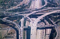
 The Judge Harry Pregerson Interchange with the Harbor Freeway (I-110).
The 105 begins at Sepulveda Boulevard (State Route 1) on the southern edge of Los Angeles International Airport (LAX), adjacent to the city of El Segundo. It proceeds generally eastward from there on, crossing the Los Angeles and San Gabriel Rivers before terminating just east of the San Gabriel River Freeway (Interstate 605) in western Norwalk.
The freeway stops short of intersecting with the Santa Ana Freeway (Interstate 5), its parent interstate. Instead, the primary lanes of I-105 terminate at an at-grade intersection with Studebaker Road.
Much of the length of the Century Freeway runs parallel to Imperial Highway.
The Green Line (Los Angeles Metro) runs in the median of I-105 for the majority of its route from Redondo Beach to Norwalk.
History
Interstate 105 was an integral part of Caltrans' 1960s master plan for the Southern California freeway system, but did not open until 1993. Many factors contributed to the delay. The growth of the environmental movement in the 1960s created resistance to new freeway construction. Fiscal difficulties brought about by the 1971 Sylmar earthquake and the California tax revolt of the late 1970s further hampered Caltrans' construction efforts.[8]
However, the major source of resistance to the freeway's construction was community opposition, and the side effects of these demands. By the early 1970s, most of the areas in the freeway's path (and thus slated to be demolished) were predominantly African-American. Resentment over previous freeway projects' effects on other black communities resulted in significant modifications to the original route. Most cities along the way, weary of the noise and visual blight created by elevated freeways, demanded that the route be built far below grade in a "trench." Also another source for resistance to the freeway's construction was that much of the areas along the I-105 path was going to be built in low income, high crime neighborhoods, which also delayed the freeway's construction until the crime in the areas went down. For his city at the center of the route, Lynwood Councilman John D. Byork fought tirelessly for the completion of the Freeway, for which he was called the "Father of the Century Freeway". His efforts, markedly at the Southern California Association of Governments had assured that the homes demolished in Lynwood had resulted in better transportation for all in Los Angeles.[9]
After construction began in the 1980s, failure to perform a full survey of the area's groundwater deposits, combined with the 20–30 foot below-grade trench through the city of Downey, resulted in buckling and cracking along the eastern portions of the route. At one point a large sinkhole opened in the Bellflower Boulevard on-ramp. This resulted in construction of an elaborate pump system along the freeway between the interchanges with I-710 and I-605.
Norwalk, opposed to the freeway's proposed route through the center of the city, blocked the route from reaching its intended terminus at the (Interstate 5); however, Caltrans had already decided to abandon that section due to the inability of the severely congested Santa Ana Freeway to accommodate any more traffic. The freeway eventually replaced Manchester Avenue and Firestone Boulevard (both State Route 42), which were roads roughly parallel to the freeway.
The family home of Brian Wilson and his brothers Dennis and Carl, founding members of the highly successful Beach Boys rock band, was demolished in the mid 1980s to make way for the freeway. A California Historic Landmark marks the site of the former home.
Throughout the difficulties, Congressman Glenn M. Anderson (D-San Pedro) tirelessly advocated for the route's construction, touting its possibilities for congestion relief along Century, Manchester, and Firestone Boulevards and the Imperial Highway; it has succeeded in these tasks, as well as relieving pressure on the Santa Monica (I-10) and San Diego (I-405) Freeways for travelers between Downtown Los Angeles and LAX. After Anderson's death in 1994, Caltrans honored him by renaming the freeway in his honor. However, the route's original name, "Century Freeway", is still used on a number of maps.
Another important figure in the freeway's history was Harry Pregerson, a United States federal judge who presided over the lawsuit concerning the freeway's construction and chose to continue presiding over the case despite being promoted to a higher level court.[10] The interchange with Interstate 110 is named the Judge Harry Pregerson Interchange in his honor.[11]
The freeway was originally signed with El Segundo as its westbound control city; however, in recent years, many of the El Segundo signs have been replaced and/or covered with "LAX Airport" signage due to the western terminus' proximity to Los Angeles International Airport.
Shortly before opening, filmmakers had access to use the empty freeway for a number of weeks to film the 1994 motion picture Speed.
Previously, the I-105 designation has been used for U.S. Route 101 (the Santa Ana Freeway) from I-5 (the Golden State Freeway) at the East Los Angeles Interchange to the connection to I-10 (the San Bernardino Freeway; this connection had been I-110); it went back to U.S. 101 in 1968.[12]
Exit list
- Note: Except where prefixed with a letter, postmiles were measured in 1964, based on the alignment as it existed at that time, and do not necessarily reflect current mileage.
The entire route is in Los Angeles County.
Location Postmile
[2][13][14]Exit
[15]Destinations Notes El Segundo R0.00 Imperial Highway west Continuation beyond SR 1 Los Angeles R0.50 1  SR 1 (Sepulveda Boulevard) / Imperial Highway east – LAX Airport
Signed as exits 1B (south) and 1C (north) westbound R1.24 1D Nash Street – LAX Airport Westbound exit and eastbound entrance R1.79 2A La Cienega Boulevard, Aviation Boulevard Westbound exit and eastbound entrance Hawthorne R2.11 2B I-405 (San Diego Freeway) – Santa Monica, Long BeachSigned as exit 2 eastbound; former SR 7 R3.05 3 Hawthorne Boulevard Westbound exit and eastbound entrance R3.32 3 Prairie Avenue Inglewood R4.71 5 Crenshaw Boulevard Los Angeles R6.77 7A Vermont Avenue R7.39 7B I-110 (Harbor Freeway) – Los Angeles, San PedroR8.90 9 Central Avenue Willowbrook R9.78 10 Wilmington Avenue Lynwood R11.51 12 Long Beach Boulevard R13.47 13 I-710 (Long Beach Freeway) – Pasadena, Long BeachParamount R14.13 14 Garfield Avenue Eastbound exit and westbound entrance R14.65 15 Paramount Boulevard Westbound exit and eastbound entrance Bellflower R15.76 16  SR 19 (Lakewood Boulevard)
Downey R16.64 17 Bellflower Boulevard Norwalk R17.82 18 I-605 (San Gabriel River Freeway)Eastbound exit and westbound entrance; signed as exits 18A (south) and 18B (north) R17.91 Hoxie Avenue – Norwalk Metro Station HOV only westbound R18.15 Studebaker Road At-grade intersection (HOV only westbound) 1.000 mi = 1.609 km; 1.000 km = 0.621 mi
Concurrency terminus • Closed/Former • Incomplete access • UnopenedReferences
- ^ SC Los Angeles-Orange County fun facts page
- ^ a b California Department of Transportation, Log of Bridges on State Highways, July 2007
- ^ http://www.dot.ca.gov/dist07/Publications/Inside7/story.php?id=203
- ^ http://www.roadstothefuture.com/I-105_Century_Fwy.html
- ^ http://www.art-poetry.info/id16.html
- ^ http://www.oac.cdlib.org/findaid/ark:/13030/kt829040j1/
- ^ CA Codes (shc:250-257)
- ^ Photo Exhibit: Constructing Interstate 105
- ^ I-105/405 interchange construction phase (by LAX Airprot
- ^ Henry Weinstein, "A Concrete Accomplishment : Transit: Long-planned Interstate 105 opens with gala festivities. Amid the tumult, Judge Harry Pregerson takes pride in job-training and housing programs he helped ensure in the freeway corridor." Los Angeles Times, October 15, 1993.
- ^ ACR 142 Assembly Concurrent Resolution
- ^ CA-Highways 105-112
- ^ California Department of Transportation, State Truck Route List (XLS file), accessed February 2008
- ^ California Department of Transportation, All Traffic Volumes on CSHS, 2005 and 2006
- ^ California Department of Transportation, California Numbered Exit Uniform System, I-105 Eastbound and I-105 Westbound, accessed February 2008
External links
- California @ WestCoastRoads.com - Interstate 105
- California Highways Rte 105
- Interstate 105 @ Asphaltplanet.ca
Auxiliary routes of Interstate 5 California: 105 • 105 (former) • 205 • 305 (unsigned) • 405 • 505 • 605 • 805 • 905 (future) — Oregon: 105 • 205 • 305 (unbuilt) • 405 • 505 (unbuilt) — Washington: 205 • 405 • 605 (unbuilt) • 705
Interstate Highways in California Signed Unsigned Business Loops Former Freeways in Greater Los Angeles Radial Hollywood (US 101/SR 170) • Golden State (I-5) • Antelope Valley (SR 14) • Glendale (SR 2) • Pasadena/Arroyo Seco Pkwy (SR 110) • San Bernardino (I-10) • Pomona (SR 60) • Santa Ana (I-5/US 101) • Laguna (SR 133) • Corona del Mar (SR 73) • Long Beach (I-710) • Seaside (SR 47) • Terminal Island (SR 103) • Harbor (I-110/SR 110) • Marina (SR 90) • Santa Monica (I-10)Circumferential Ventura (US 101/SR 134) • Foothill (I-210) • San Gabriel River (I-605) • Orange (SR 57) • Costa Mesa (SR 55) • Artesia (SR 91) • Garden Grove (SR 22) • Century (I-105) • Gardena (SR 91) • San Diego (I-405) • Moorpark (SR 23) • Ojai (SR 33) • Ronald Reagan (SR 118) • Santa Paula (SR 126)Inland Empire Chino Valley (SR 71) • Foothill (SR 210) • Moreno Valley (SR 60) • Riverside (SR 91) • San Bernardino (I-10/I-215) • I-10 • I-15 • I-215 • SR 259 • SR 330Toll Categories:- Interstate Highways in California
- Interstate 5
- Southern California freeways
- Three-digit Interstate Highways
- Roads in Los Angeles County, California
- Inglewood, California


Wikimedia Foundation. 2010.