- Interstate 805
Infobox road
state=CA
type=I
route=805
section=621
maint=Caltrans 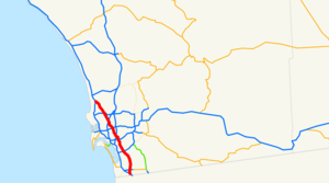
alternate_name=Jacob Dekema Freeway
length_mi=28.51
length_round=2
length_ref= [http://www.dot.ca.gov/hq/structur/strmaint/brlog2.htm January 1, 2006 California Log of Bridges on State Highways] ]
history=1959 as LRN, 1964 as a number
direction_a=South
terminus_a=Jct|state=CA|I|5 in San Ysidro
junction=Jct|state=CA|I|8 in San Diego
direction_b=North
terminus_b=Jct|state=CA|I|5 near Del Mar
previous_type=I
previous_route=780
next_type=I
next_route=880Interstate 805 (I-805 - also referred to as "The 805"), is a bypass
interstate highway running through the San Diego metropolitan area. It is officially known as the Jacob Dekema Freeway after Jacob Dekema, a pioneering force from theCalifornia Department of Transportation (Caltrans) who helped shape the San Diego freeway system.This route is part of the
California Freeway and Expressway System [http://www.leginfo.ca.gov/cgi-bin/displaycode?section=shc&group=00001-01000&file=250-257 CA Codes (shc:250-257)] ] .Route description
I-805 is an alternate bypass route of Interstate 5. The southern terminus of the 805 is at I-5 just a few miles north of the
United States–Mexico border at the San Diego district of San Ysidro. I-805 then goes through the cities of Chula Vista and National City before reentering San Diego. The freeway then passes though the San Diego neighborhoods of North Park, Mission Valley, Clairemont, and University City before terminating at I-5 in Sorrento Valley.Eight to ten lanes throughout, Interstate 805 has evolved into a busy commuter route from the International Border into the exploding South Bay communities of Chula Vista (including Rancho del Rey and Eastlake) and National City. The freeway also leads into the relatively new business parks near University City (via Governor Drive and La Jolla Village Drive) and Sorrento Valley. As more companies locate along the route of Interstate 805, more traffic utilizes the route as an important connector to get from home to work. In addition to commuter traffic, the freeway is one of two north-south freeways that reach Mexico. Traffic to and from the border is also very common along Interstate 805.
The 805 also includes a towering bridge over Mission Valley and Interstate 8, including San Diego County's only symmetrical
stack interchange .History
Plans for the 805 were passed in legislature in
1959 as Legislative Route Number 241. It was approved as a chargeable interstate in1958 , and declared a signed state route in1964 . The freeway was then built between 1970 and 1975.A major expansion of the 805-5 merge zone was opened to traffic on April 3rd, 2007. Including HOV Lanes and local bypass lanes, this merge spans 22 lanes at the widest point. Work is also underway to add two HOV Lanes between State Route 52 and Mira Mesa Boulevard.
As of 2007, a three-year project is underway to allow robot controlled vehicles, including buses and trucks, to use a special lane. The intention is to allow the vehicles to travel at shorter following distances and thereby allow more vehicles to use the lanes. The vehicles will still have drivers since they need to enter and exit the special lanes. The system is being designed by
Swoop Technology , based in San Diego county. [cite news | url=http://www.wired.com/cars/futuretransport/magazine/15-08/st_robot | title=Robot Buses Pull In to San Diego's Fastest Lane | publisher=Wired | date=July 24 2007 | accessdate=2007-08-19]Exit list
:"Note: Except where prefixed with a letter,
postmile s were measured in 1964, based on the alignment as it existed at that time, and do not necessarily reflect current mileage."The entire route is in San Diego County.References
External links
* [http://www.westcoastroads.com/california/i-805_ca.html California @ WestCoastRoads.com - Interstate 805]
* [http://www.cahighways.org/505-805.html#805 California Highways: I-805]

Wikimedia Foundation. 2010.