- Interstate 8
-
For other uses, see I8 (disambiguation).
Interstate 8

Route information Length: 348.25 mi[1] (560.45 km) Existed: 1964 – present Major junctions West end: Sunset Cliffs Boulevard in San Diego, CA  I-5 in San Diego, CA
 I-15 in San Diego, CA
 US 95 in Yuma, AZ
East end:  I-10 near Casa Grande, AZ
Highway system Main route of the Interstate Highway System
Main • Auxiliary • Business
←  SR 7
SR 7CA SR 9  →
→←  SR 802
AZ I-10 →
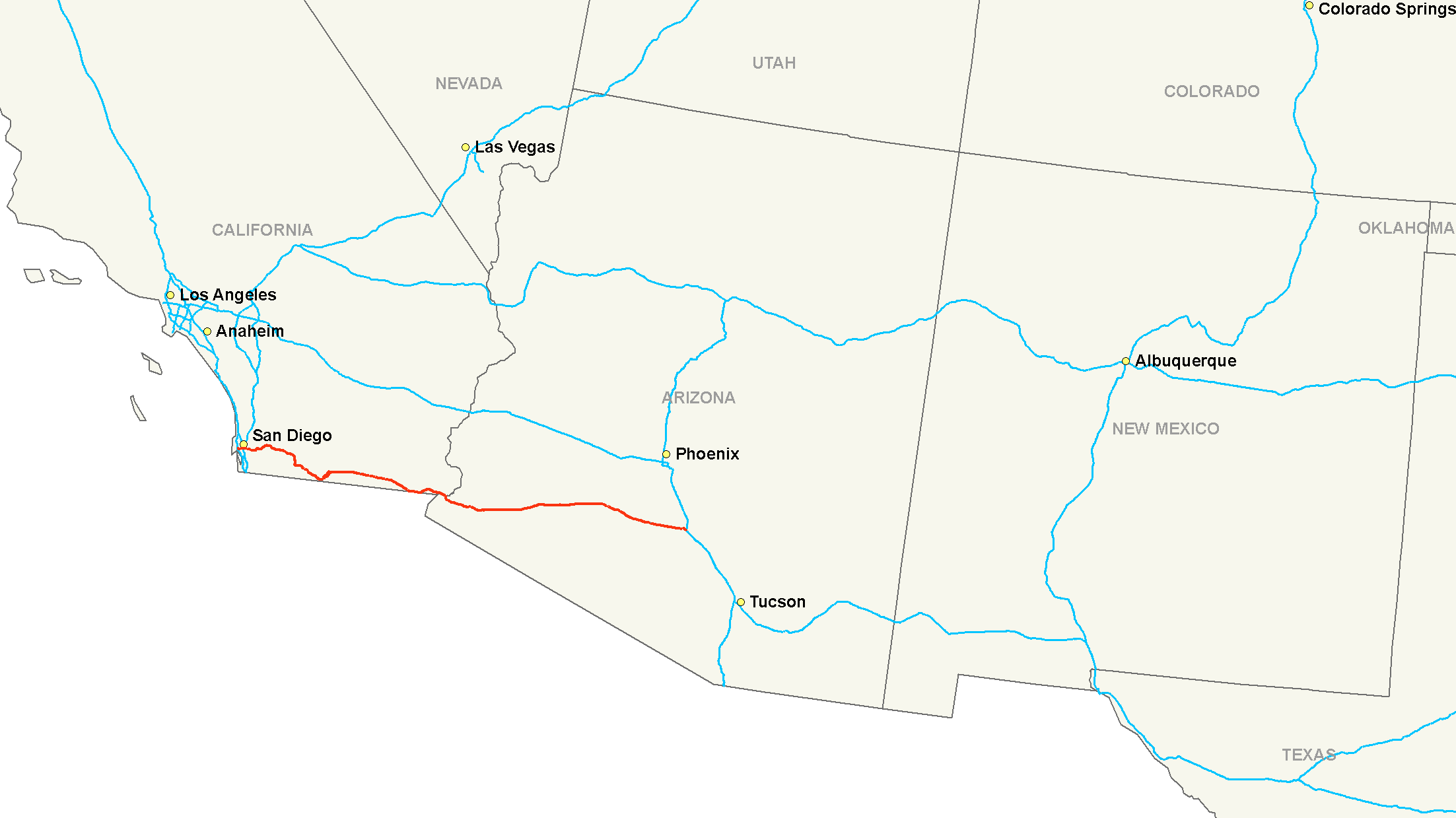
Interstate 8 (I-8) is an Interstate Highway in the southwestern United States. It runs from the southern edge of Mission Bay at Sunset Cliffs Blvd, in San Diego, California, almost at the Pacific Ocean, to the junction with Interstate 10, just southeast of Casa Grande, Arizona.[2] In California, especially from eastern San Diego County to points east, Interstate 8 runs very close to the United States-Mexico border where high-voltage transmission line Path 46 links Southern California to Mexico. At points in eastern Imperial County, the border is no more than half a mile (1 km) south of the Interstate.
I-8 at the Mountain Springs/In Ko Pah grade is routed down two separate canyons, as the freeway descends 4,000 vertical feet in 11 miles. This is one of the widest medians on the entire Interstate Highway System. In places, the median is over 1.5 miles (2.4 km) wide. I-8 also has the lowest above-ground elevation of any interstate at 52 feet (16 m) below sea level near El Centro, California. (The lowest point on the entire interstate highway system is in the Fort McHenry Tunnel while crossing under the Inner Harbor of Baltimore, Maryland on I-95. The highway bottoms out at −107 feet (−32.6 m).)
Contents
Route description
I-8 in California
Lengths mi km CA 169.92 273.46 AZ 178.33 286.99 Total 348.25 560.45 I-8 is part of the California Freeway and Expressway System[3] and is eligible for the State Scenic Highway System,[4] though it is not an official state scenic highway.[5] It is officially known as the Border Friendship Route from San Diego to the Arizona state line.[6] It is also signed as the Ocean Beach Freeway west of Interstate 5 and as the Kumeyaay Highway (after the local Native American tribe) for the entire length within San Diego County.
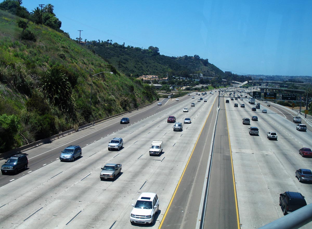
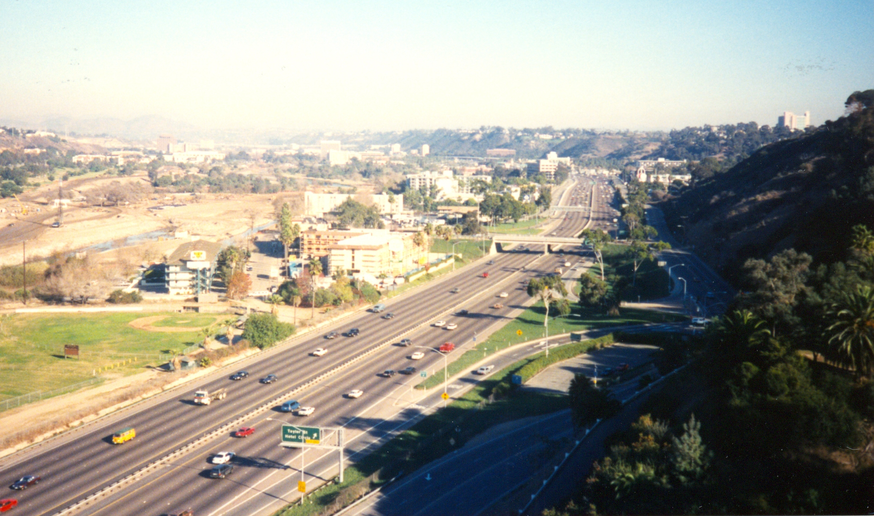
Interstate 8 begins at the intersection of Sunset Cliffs Boulevard and Nimitz Boulevard. For its first few miles, it parallels the San Diego River Floodway east. Near Old Town, I-8 intersects with Interstate 5 as well as with the former State Route 209. I-8 continues eastward, bisecting the area known as "Hotel Circle." As I-8 enters Mission Valley, it has junctions with State Route 163, Interstate 805 (Jack Schrade Interchange), and Interstate 15 and its continuation, State Route 15. In La Mesa, I-8 interchanges with State Route 125. I-8 continues into El Cajon, where it intersects with State Route 67 before it ascends into the mountains and the Cleveland National Forest, traveling through towns such as Alpine and Pine Valley. I-8 intersects with State Route 79 in the national forest before descending into the Imperial Valley and passing through the La Posta and Campo Indian reservations. In Boulevard, I-8 intersects with the eastern end of State Route 94.[7][8]
Interstate 8 straddles the San Diego-Imperial county line for a few miles before turning east. While going over the mountain pass into the Imperial Valley, I-8's roadways are separated by a considerable distance. This is because the eastbound lanes traverse the pass on the former roadbed of US-80. The westbound lanes were placed on a different routing. In the Imperial Valley, I-8 intersects with State Route 98, a highway leading to Calexico. I-8 then goes through Coyote Wells before entering the city of El Centro several miles later. In El Centro, I-8 intersects with State Route 86 and State Route 111, both north–south routes which connect to Interstate 10 in the Coachella Valley (north of the Salton Sea), before State Route 115 and State Route 98 merge with I-8. The freeway then traverses the Imperial Sand Dunes Recreation Area and intersects with State Route 186 leading to Mexico. Interstate 8 then passes through Felicity, California and Winterhaven before crossing the Colorado River into Yuma, Arizona[7][8] on a bridge built in 1978.[9]

I-8 in Arizona
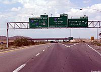
I-8 enters Arizona from California at the Colorado River bridge at Yuma. It initially heads south through Yuma until the interchange with US 95 where the freeway begins to make the turn to the east. I-8 closely follows the alignment of the old US 80 route and in some locations, the US 80 alignment was upgraded and became I-8. West of Wellton, the highway curves towards the north to take a northeasterly course. Through this part of Arizona, I-8 passes along the northern edge of the Barry M. Goldwater Air Force Range and to the south of the Yuma Proving Ground. It keeps a northeastern heading until it reaches Gila Bend, Arizona where it intersects SR 85 which leads to Phoenix. After leaving Gila Bend, I-8 takes a southeastern heading as it passes through the Sonoran Desert National Monument. After exiting the monument, the highway continues on an easterly heading to a junction with SR 84 that will parallel I-8 to the north and go through Casa Grande while I-8 will pass to the south of the city. I-8 reaches its eastern terminus at an interchange with I-10 which continues on to Tucson.[10][11]
History
I-8 was part of the original 1957 plan of Interstates, following US-80 from San Diego to Gila Bend, Arizona, then AZ-84 from there to Casa Grande.
California
Interstate 8 replaced California's section of U.S. Route 80, which had existed from around 1929 until 1964. The original designations of US-80 in California were as LRN 12 (since 1909) from San Diego to El Centro, and as LRN 27 (since 1915) from El Centro to Arizona. I-8 was accepted as a chargeable interstate in 1957,[9] and was signed as Interstate 8 in 1964.[12] The "Ocean Beach Freeway" section west of I-5 was completed by 1967[13] as LRN 286 and was later designated as SR 109; it was later added to Interstate 8 in 1972.[9]
Arizona
The portion of the route of I-8 between Yuma and Gila Bend was originally part of the proposed state system of highway in 1921.[14] In 1926, this section became part of the cross-country highway US 80. The route was not paved at this time, but was a gravel road along the entire corridor.[15] In 1928, the portion of I-8 between Gila Bend and Casa Grande was designated as SR 84.[16] By 1929, a small portion of the highway was paved near Yuma and SR 84 was under construction.[17] By 1930, SR 84 was completed, but not paved and the segment of US 80 between Astec and Sentinel had been paved.[18] By 1931, the entire portion of the highway under the US 80 designation had been paved.[19] Paving of the SR 84 had commenced by 1934, with the portion of the highway in Maricopa County being paved.[20] By 1935, the entire future corridor of I-8 had been paved from Yuma to Casa Grande.[21]
With the coming of the Interstate Highways, the corridor was to be upgraded to Interstate standards. By 1963, this process was in progress with portions of the highway between Mohawk and Gila Bend, and between Gila Bend and Stanfield having been upgraded.[22] By 1971, I-8 was nearly complete including a new alignment east of Yuma built parallel and to the south of the original US 80 alignment. A new alignment was also built to the south of the SR 84 alignment at the eastern end of the highway from southwest of Stanfield to the eastern terminus at I-10 southeast of Casa Grande. The only portions of I-8 not completed at this time were the Casa Grande bypass and the western end near Yuma.[23] As the Interstate was completed, the highways that it replaced were removed from the state highway system. In 1973, the SR 84 designation was removed from the highway from Gila Bend to the split where I-8 followed a new alignment southwest of Stanfield.[24] In 1977, the US 80 designation was removed from this stretch in favor of I-8.[25]
Exit list
Exits in California
- Note: Except where prefixed with a letter, postmiles were measured in 1964, based on the alignment as it existed at that time, and do not necessarily reflect current mileage. The numbers reset at some county lines; the start and end postmiles in each county are given in the county column.
County Location Postmile
[26][27][28]Exit
[29]Destinations Notes San Diego
SD T0.41-R77.77San Diego T0.41-T0.47 Nimitz Boulevard, Sunset Cliffs Boulevard – Mission Bay Park At-grade intersection L1.21 1 Mission Bay Drive, Sports Arena Boulevard to I-5 southWestbound exit and eastbound entrance L2.38 2 I-5 south (San Diego Freeway) – Downtown San DiegoNo access from I-8 west to I-5 south and I-5 north to I-8 east L2.38 2A I-5 north (San Diego Freeway) – Los AngelesWestbound exit and eastbound entrance; no access from I-8 east to I-5 north and I-5 south to I-8 west 2B Rosecrans Street Westbound exit and eastbound entrance; former SR 209 south R0.36 2C Morena Boulevard Westbound exit and eastbound entrance 0.95 3 Taylor Street, Hotel Circle 2.23 4A Hotel Circle Westbound exit is via exit 3 2.41 4  SR 163 (Cabrillo Freeway) / I-5 north – Escondido, Downtown San Diego
Signed as exits 4B (CA-163 south) and 4C (CA-163 north to I-5 north) eastbound and exits 4A (CA-163 south) and 4B (CA-163 north) westbound 3.04 5 Mission Center Road, Auto Circle 3.90 6A Texas Street, Qualcomm Way 4.38 6B  I-805 (Jacob Dekema Freeway) – Los Angeles, National City, Chula Vista
5.64 7 I-15 (Escondido Freeway) – Riverside, San DiegoSigned as exits 7A (north) and 7B (south) eastbound, 7A (south) and 7B (north) westbound 6.27 8 Mission Gorge Road, Fairmount Avenue Eastbound exit is part of exit 7 7.06 9 Waring Road 8.34 10 College Avenue Serves San Diego State University La Mesa 9.59 11 Lake Murray Boulevard, 70th Street 10.57 12 Fletcher Parkway, Baltimore Drive 10.97 13A Spring Street – Downtown La Mesa No westbound exit 11.10 13A El Cajon Boulevard Westbound exit and eastbound entrance; former I-8 Bus. west 11.76 13B Jackson Drive, Grossmont Boulevard No eastbound entrance 12.12 14B La Mesa Boulevard, Grossmont Center Drive Signed as exit 14B weastbound 12.34 14A 
 SR 125 to SR 94
Signed as exit 14A eastbound 12.65 14C Severin Drive, Fuerte Drive El Cajon 13.66 15 El Cajon Boulevard (I-8 Bus. east) Eastbound exit and westbound entrance 14.59 16 Main Street 15.30 17A Johnson Avenue Eastbound exit and westbound entrance 15.80 17  SR 67 north / Magnolia Avenue – Santee, Lakeside, Ramona
Signed as exits 17B (SR 67) and 17C (Magnolia Avenue) eastbound 16.47 18 Mollison Avenue 17.36 19 2nd Street Former SR 54 west 17.83 20A East Main Street (I-8 Bus. west) Westbound exit and eastbound entrance R18.73 20B Greenfield Drive – Crest Signed as exit 20 eastbound R20.04 22 Los Coches Road – Lakeside R21.82 23 Lake Jennings Park Road R25.69 27 Dunbar Lane – Harbison Canyon R28.46 30 Tavern Road (I-8 Bus. east) – Alpine R31.34 33 Willows Road, Alpine Boulevard (I-8 Bus. west) – Alpine R34.33 36 East Willows Road R37.83 40  SR 79 north (Japatul Road) – Julian
R43.53 45 Pine Valley, Julian R44.93 47 Sunrise Highway (CR S1) R48.84 51 Buckman Springs Road R51.98 54 Kitchen Creek Road – Cameron Station R61.15 61 Crestwood Road – Live Oak Springs R65.90 65 SR 94 west – Campo, BoulevardR73.95 73 Jacumba R77.58 77 In-Ko-Pah Park Road Imperial
IMP R0.00-R96.99R3.09 80 Mountain Springs Road R10.01 87  SR 98 east – Calexico
Eastbound exit and westbound entrance Ocotillo R11.92 89 Imperial Highway (CR S2) – Ocotillo R23.48 101 Dunaway Road R29.93 107 Drew Road (CR S29) – Seeley R33.99 111 Forrester Road (CR S30) El Centro R36.97 114 Imperial Avenue (I-8 Bus. east) – El Centro R37.97 115  SR 86 (4th Street, I-8 Bus. west) – El Centro
R38.96 116 Dogwood Road (CR S31) R40.94 118  SR 111 – Brawley, Indio, Calexico
Signed as exits 118A (south) and 118B (north) R42.54 120 Bowker Road R47.78 125 SR 7 south / Orchard Road (CR S32)R50.49 128 Bonds Corner Road Former SR 115 R53.50 131  SR 115 (Van Der Linden Road) – Holtville
Former US 80 R65.75 143 SR 98 west – CalexicoR68.83 146 Brock Research Center Road R73.48 151 Gordons Well 80.80 156 Grays Well Road R83.82 159 Ogilby Road (CR S34) Felicity R88.70 164 Sidewinder Road R90.74 166  SR 186 south (Algodones Road) – Andrade
R94.98 170 Winterhaven Drive (CR S24, I-8 Bus. east) – Winterhaven R96.55 172 Winterhaven Drive, Fourth Avenue (I-8 Bus. west) – Winterhaven R96.99 Arizona state line 1.000 mi = 1.609 km; 1.000 km = 0.621 mi
Concurrency terminus • Closed/Former • Incomplete access • UnopenedExits in Arizona
County Location Mile[10] # Destinations Notes Yuma Yuma 0.59 1 Redondo Center Drive, Giss Parkway 2.23 2 US 95 (16th Street) – San Luis, Quartzsite, Yuma Proving Grounds3.98 3  SR 280 south (Avenue 3E) – Yuma International Airport, Marine Corps Air Station Yuma, Yuma County Fairgrounds
7.66 7 Araby Road – Arizona Western College 9.44 9  I-8 Bus. (Avenue 8½E)
12.27 12 Fortuna Road 14.28 14 Foothills Boulevard 21.06 21 Dome Valley 30.84 30 Avenue 29E – Wellton 37.99 37 Avenue 36E – Roll 42.10 42 Avenue 40E – Tacna 54.98 54 Avenue 52E – Mohawk Valley 67.49 67 Dateland 73.53 73 Aztec 78.51 78 Spot Road Maricopa 87.10 87 Sentinel, Hyder, Auga Caliente 102.34 102 Painted Rock Road 106.56 106 Paloma Road 111.49 111 Citrus Valley Road Gila Bend 115.68 116  I-8 Bus. east / SR 85 – Phoenix, Ajo
119.47 119 I-8 Bus. west (Butterfield Trail) to SR 85 north / I-10140.86 140 Freeman Road 144.60 144 Vekol Valley Road Pinal 151.73 151 
 SR 84 east to SR 347 north – Maricopa
161.61 161 Stanfield 167.61 167 Montgomery Road 169.72 169 Bianco Road 172.62 172 Thornton Road – Casa Grande 174.62 174 Trekell Road – Casa Grande Casa Grande 178.36 178 I-10 – Phoenix, TucsonEastbound exit and westbound entrance; signed as exits 178A (west) and 178B (east) El Centro business loop
Interstate 8 Business
Location: El Centro, California Business Loop Interstate 8 is a business loop route that diverges from Interstate 8 in El Centro, California to pass through the downtown area. Business Interstate 8 originates and terminates with I-8 and acts as a direct link to El Centro as I-8 bypasses the downtown area.
Business Interstate 8's path through El Centro traces roughly three sides of a rectangle with I-8 constituting the fourth side. Bus-8 begins at its western terminus with I-8 by going north along Imperial Avenue. When Bus-8 reaches the intersection of Adams Avenue it turns east along that road. Along this stretch Bus-8 is joined by State Route 86 which approaches from the north along Imperial Ave, and by Imperial County Route S80 which approaches from the west along Adams Ave. The three routes continue joined as Adams Ave ends and turns south along Fourth Ave where S80 then turns to continue east. Bus-8 and SR 86 continue south running concurrent until Bus-8 reaches its eastern terminus with I-8.
The Imperial Ave section of Bus-8 is city maintained by El Centro, the rest of Bus-8 is state maintained due to its concurrency with SR 86.
Along its concurrency with SR 86, Bus-8 is part of the Juan Bautista De Anza National Historic Trail.
References
- ^ Federal Highway Administration (2002-10-31). "FHWA Route Log and Finder List: Table 1". http://www.fhwa.dot.gov/reports/routefinder/table1.htm. Retrieved 2007-03-28.
- ^ Google, Inc. Google Maps – overview map of I-8 (Map). Cartography by Google, Inc. http://maps.google.com/maps?f=d&hl=en&geocode=2863822521104466740,32.754740,-117.235610&saddr=I-8+E+%4032.754740,+-117.235610&daddr=32.820893,-111.690445&mra=mi&mrsp=1,0&sz=14&sll=32.812382,-111.692848&sspn=0.032606,0.05785&ie=UTF8&ll=32.87036,-114.345703&spn=4.17026,7.404785&z=7. Retrieved 2008-02-15.
- ^ CA Codes (shc:250-257)
- ^ CA Codes (shc:260-284)
- ^ California Department of Transportation, Officially Designated Scenic Highways, accessed 2009-12-16
- ^ 2007 Named Freeways, Highways, Structures and Other Appurtenances in California. Caltrans. pp. 120. http://www.dot.ca.gov/hq/tsip/hseb/products/Named_Freeways.pdf. Retrieved 2007-10-18.
- ^ a b Rand McNally (2008). The Road Atlas (Map). p. 15,17.
- ^ a b Thomas Brothers (2000). California Road Atlas and Driver's Guide (Map). p. 107,111,112,212,213,214,V.
- ^ a b c California Highways
- ^ a b Arizona Department of Transportation. "2006 ADOT Highway Log". http://tpd.az.gov/data/reports/2006SHSLog.pdf. Retrieved 2008-04-11.
- ^ Google, Inc. Google Maps – overview map of I-8 in Arizona (Map). Cartography by Google, Inc. http://maps.google.com/maps?f=d&hl=en&geocode=12292208217460437544,32.728310,-114.617480%3B401209425362210788,32.817011,-111.683029&saddr=I-8+E+%4032.728310,+-114.617480&daddr=Exit+178A+%4032.817011,+-111.683029&doflg=ptm&sll=32.795685,-113.150255&sspn=3.181171,5.119629&ie=UTF8&z=8. Retrieved 2008-04-11.
- ^ 1964 California Highway Renumbering
- ^ WestCoastRoads
- ^ Arizona Highway Department (1921). Map of Proposed State Highway System of Arizona (Map). http://www.rockymountainroads.com/maps/1921-az.html. Retrieved 2008-05-04.
- ^ Arizona Highway Department (1926). Map of Arizona (Map). http://www.rockymountainroads.com/maps/1926-az.html. Retrieved 2008-05-03.
- ^ Arizona Department of Transportation. "ADOT Right-of-Way Resolution 1928-P-144". http://www.azhighwaydata.com/resolutions/?resnum=1928-P-144. Retrieved 2008-05-04.
- ^ Arizona Highway Department (1929). Map of Arizona (Map). http://www.rockymountainroads.com/maps/1929-az.html. Retrieved 2008-05-04.
- ^ Arizona Highway Department (1930). Condition Map of State Highway System (Map). http://www.rockymountainroads.com/maps/1930-az.html. Retrieved 2008-05-04.
- ^ Arizona Highway Department (1931). Condition Map of State Highway System (Map). http://www.rockymountainroads.com/maps/1931-az.html. Retrieved 2008-05-04.
- ^ Arizona Highway Department (1934). Condition Map of State Highway System (Map). http://www.rockymountainroads.com/maps/1934-az.html. Retrieved 2008-05-04.
- ^ Arizona Highway Department (1935). Road Map of Arizona (Map). http://www.arizonaroads.com/maps/index.html. Retrieved 2008-05-04.
- ^ Rand McNally (1963). Road Map of Arizona (Map). http://www.rockymountainroads.com/maps/1963-az.html. Retrieved 2008-05-04.
- ^ Arizona Highway Department (1971). Road Map of Arizona (Map). http://www.rockymountainroads.com/maps/1971-az.html. Retrieved 2008-05-04.
- ^ Arizona Department of Transportation. "ADOT Right-of-Way Resolution 1973-20-075". http://www.azhighwaydata.com/resolutions/?resnum=1973-%20-075. Retrieved 2008-05-04.
- ^ Arizona Department of Transportation. "ADOT Right-of-Way Resolution 1977-16-A-048". http://www.azhighwaydata.com/resolutions/?resnum=1977-16-A-048. Retrieved 2008-05-04.
- ^ California Department of Transportation, State Truck Route List (XLS file), accessed February 2008
- ^ California Department of Transportation, Log of Bridges on State Highways, July 2007
- ^ California Department of Transportation, All Traffic Volumes on CSHS, 2005 and 2006
- ^ California Department of Transportation, California Numbered Exit Uniform System, Interstate 8 Freeway Interchanges, Retrieved on 2009-02-05.
External links
- California Highways, Routes 1 through 8, CaHighways.org
- Old SR 209 and the Cabrillo National Monument, Floodgap.com
Main Interstate Highways (major interstates highlighted)
4 5 8 10 12 15 16 17 19 20 22 24 25 26 27 29 30 35 37 39 40 43 44 45 49 55 57 59 64 65 66 68 69 70 71 72 73 74 75 76 (W) 76 (E) 77 78 79 80 81 82 83 84 (W) 84 (E) 85 86 (W) 86 (E) 87 88 (W) 88 (E) 89 90 91 93 94 95 96 97 99 H-1 H-2 H-3 Unsigned A-1 A-2 A-3 A-4 PRI-1 PRI-2 PRI-3 Lists Primary Main - Intrastate - Suffixed - Temporary - Future - Gaps Auxiliary Main - Future - Unsigned Other Standards - Business - Bypassed - Tolled Interstate Highways in Arizona Current Cancelled Interstate Highways in California Signed Unsigned Business Loops Former Categories:- Interstate Highway System
- Interstate 8
- Juan Bautista de Anza National Historic Trail
- Interstate Highways in Arizona
- Yuma, Arizona
- Gila River
- Transportation in Yuma County, Arizona
- Transportation in Maricopa County, Arizona
- Transportation in Pinal County, Arizona
- Interstate Highways in California
- Southern California freeways
- Roads in San Diego County, California
- Roads in Imperial County, California

Wikimedia Foundation. 2010.