- Interstate 22
-
"I-22" redirects here. For other uses, see I22.
Interstate 22
Route information Length: 213 mi[1] (342.79 km) Major junctions West end:  I-269 near Memphis, Tennessee
East end: 
 I-65 / US-31 in Birmingham, Alabama
Highway system Main route of the Interstate Highway System
Main • Auxiliary • BusinessInterstate 22 (I-22), when it is completed, will follow the U.S. Highway 78 corridor along a 213-mile-long (343-kilometer) route from Memphis, Tennessee, to Birmingham, Alabama, as an Interstate Highway.[2] Interstate 22 will connect Interstate 240 (Tennessee) and Interstate 40 (indirectly) in the northwest with Interstate 65 and (indirectly) Interstate 20 in the southeast. Hence, I-22 will help form a freeway to connect downtown Atlanta with Birmingham, Memphis, Little Rock, and Oklahoma City.
Along its way through Alabama and Mississippi, Interstate 22 will also serve the towns of Jasper, Ala., Winfield, Ala., Hamilton, Ala., Tupelo, MS, Holly Springs, MS, and New Albany, MS. Major portions of this highway have either been built new or converted to Interstate Highway standards as of early 2011. However, according to Federal law, two key interchanges need to be completed before this highway is officially designated as part of the Interstate Highway System.[3][4] To be completed are its major interchanges with Interstate 65 in Alabama and with Interstate 240 a short distance into Tennessee.
Contents
Development
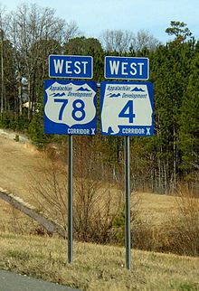
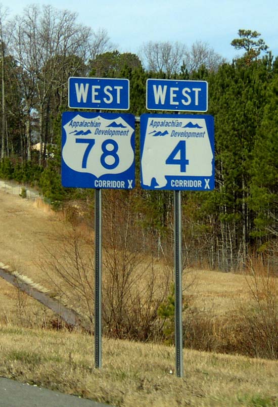
The part of Interstate 22 just east of Fulton, Mississippi, was approved by Congress as "Corridor X" in 1978, as a part of the Appalachian Development Highway System, and parts of I-22 have been under construction ever since.[5] Corridor X was also designated as "High Priority Corridor 10" in the Federal National Highway System Designation Act of 1995, and as "High Priority Corridor 45" in later legislation.[1]
Two small but costly portions of Interstate 22 remain to be completed, and these are under construction as of early 2011. The one missing part in Alabama is only 2.5 miles (4.0 km) long and it is in Jefferson County, and this is from "Coalburg Road" near Fultondale to U.S. Highway 31 on the northmost edge of Birmingham.[6] This short section consists mostly of the major highway interchange with Interstate 65 and U.S. Highway 31.[6] The other missing part is the short stretch from the state line between Mississippi and Tennessee to its final interchange with an Interstate Highway just southeast of Memphis. The exact location of this western terminus has not yet been decided on as of early 2011, but Interstate 269 (when completed)[7] and Interstate 240 are the two possibilities.
Future Interstate 22 now covers nearly the full distance between Birmingham and suburban Memphis, stopping short of its lone major interchange in Alabama at I-65.[6] In Mississippi, I-22 runs from the Alabama state line across the state, and past the location of its prospective interchange with I-269 to the Tennessee state line at the Memphis city limits. This is about miles short of an interchange with Interstate 240 in Shelby County, Tennessee. However, whether a highway all the way to I-240 is ever constructed is still an open question because such a highway would need to go through a heavily-industrialized area of Memphis. This includes a large intermodal railroad and highway facility adjacent to the current U.S. Highway 78. Government funding for the two remaining sections of I-22 has been a priority for Senator Richard Shelby, who served as the Chairman of the Senate's Transportation Subcommittee.[5]
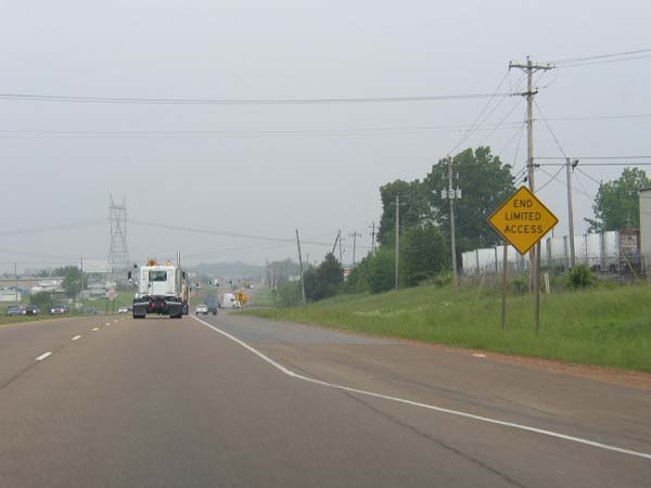
In 2004, Corridor X was designated as the "Future Interstate 22" by Public Law Number 108-199,[8] and the designation was made official on April 18, 2005.[9] In Alabama and Mississippi, blue signs reading "FUTURE/I-22/CORRIDOR" at left and an I-22 shield with "FUTURE" instead of "INTERSTATE" at the right were unveiled on April 18, 2005.[9]
U.S. Highway 78
Future Interstate 22 is also called U.S. Highway 78. Nearly all of U.S. Hwy. 78 today has been moved from its original roadway from Graysville, Ala. through to Memphis. The fate of U.S. Hwy. 78 once Corridor X officially becomes I-22 is still undecided. Its original highway between Graysville and Memphis now bears several different State Highway designations. From Graysville to Jasper, it is called Alabama Highway 5. For a short stretch in western Jasper, it is designated as Alabama Highway 69, but once Highway 69 turns south in western Jasper, the highway becomes Alabama Highway 118. This remains its designation as until it reaches Winfield, where it becomes U.S. Highway 43, and at Guin, U.S. Highway 278 joins the highway. This continues through the town of Hamilton. In Hamilton, old Hwy. 78 becomes Alabama Highway 74 westward through its intersection with I-22 at exit seven. From exit seven though the Mississippi state line, the current U.S. Hwy. 78 and Future I-22 are the same highway. (Here, the new I-22 has been built on top of the old U.S. 78.)
At the Mississippi state line, westbound travelers can look to their right and see the old U.S. 78 highway. This is still used today as a local road, but it is not accessible from Corridor X.) At exit 113 on Corridor X, the old highway is accessible via Mississippi Hwy. 23 just north of Corridor X, and westbound from there it is Mississippi Hwy. 178.
Miss. Hwy. 178 continues into Fulton, Miss. At Fulton, due to the existence of the Tennessee Tombigbee Waterway, the original highway no longer exists just west of downtown Fulton. Then it can be entered again via I-22 at exit 101 as Miss. Hwy. 178 again. The old highway (as Mississippi 178) continues to run parallel with and south of I-22 into and past the town of Tupelo where it crosses Corridor X again at exit 81. The original routing remains parallel to and north of Corridor X through Sherman, Blue Springs, New Albany, Myrtle, and Hickory Flat before crossing Corridor X again at exit 48. It now runs parallel to and south of Corridor X through Potts Camp before crossing Corridor X the last time between Potts Camp and Lake Center and then it continues into Holly Springs, Red Banks, Victoria, Byhalia, and finally through Olive Branch before reconnecting with I-22 at an at-grade intersection just inside Tennessee near the present end of the controlled access highway. The decision to be made by the three State Highway Departments is to whether to decommission U.S. Hwy. 78 from just north of Birmingham, all the way to downtown Memphis; to redesignate the old highway as U.S. Hwy. 78; or to have Interstate 22 also designated as U.S. Highway 78 on its entire distance between Birmingham and Memphis. There has been no indication as of January 2011 as to when such a decision might be made.
Alabama
Approximately 93 miles (150 km) of Future Interstate 22 is open to traffic in Alabama. The completed section of the route between the Mississippi state line and Jasper was opened to traffic on November 22, 2005.[10] Exits on the Jasper Bypass portion of I-22 were originally numbered using a kilometer-based sequence, but they have been renumbered according to the highway's mileposts. A 6-mile (9.7 km) segment between Graysville and Brookside was opened in June 2007,[11] and another 20-mile (32 km) section of Future I-22 between Jasper and Graysville was opened in November 2007.[12] A 1.8-mile (2.9 km) segment between Cherry Avenue in Forestdale to a point about 2.5 miles (4.0 km) short of Interstate 65 near Fultondale, including an interchange with Coalburg Road, which was opened in December 2009. [6] This has been the last segment of I-22 in Alabama to open for traffic so far. Next comes the connection of I-22 with Interstate 65 and U.S. Highway 31.[6] The Alabama Department of Transportation also plans to widen "Coalburg Road" its interchange with I-22 southward to Daniel Payne Drive (which leads to I-65) in order to allow heavy trucks to use it.[13] However, no timetable for this project has been announced by ALDOT.[13] Signs are now in place on Daniel Payne Drive (westbound) informing truckers that access to I-22 is not allowed from Daniel Payne Drive.
Plans call for Interstate 22 to be completed to I-65 in 2014, with the 14-bridge stack interchange in Birmingham.[14] Construction to widen I-65 to four lanes in both directions has begun from just south of the upcoming highway interchange southward to the 16th Street interchange in Birmingham. Under the present design, I-22 will terminate at I-65, but the highway will continue a short distance beyond I-65 as a long pair of ramps to Highway 31.[15] The construction of the roadbed and excavation of a ridge approximately 500 yards west of I-65 can easily be seen by motorists on I-65. Another associated project will be a widening of I-65 from its interchange with I-22 northward to the Walker Chapel Road exit.[16]
The Alabama Department of Transportation had announced that the awarding of contracts for the construction of the final segment if I-22, including its large interchange with I-65 and Highway 31 would have been carried out in August 2009 -- with the construction to begin shortly afterwards. However funding delays postponed these into 2010. On March 19, 2010, President Barack Obama signed the HIRE (Hiring Incentives to Restore Employment) Act into law, which included an extension of Federal Highway funding through the end of 2010. This extension gave the Department of Transportation the opportunity to proceed with its plans for the construction of final segment of I-22 in Alabama. The opening of the bids for this project began on May 21, 2010. The Department of Transportation announced on June 16, 2010 that the project has been awarded to the company, Archer Western Contractors for $168,600,000.[17]
The construction work began in October 2010, and it has a projected completion date of October 15, 2014.[14] This project is the most expensive highway project ever undertaken in Jefferson County, and it the highest-priced contract that the Alabama Department of Transportation has ever awarded.[14]
Various lighting projects have been completed along I-22 since 2008. These include lighting at exits 85, 30, and 14. I-22 is a six-lane highway between exit 63, at Jasper, and the current terminus of the highway at exit 93, at Coalburg Road. A stretch of I-22 between exits 57 and 52 is also six-lane freeway. The Department of Transportation, as of July 2010, has no plans to construct an Alabama Welcome Center for eastbound travelers from Mississippi into Alabama.
Mississippi

Parts of the highway in Mississippi must be upgraded to current Interstate standards. The main areas involved are an approximately two mile portion through New Albany where both an insufficient median and substandard bridges exist.[18] Another area is scattered along the entire Mississippi portion where work to improve the shoulders to interstate standards is yet to be done as well as repaving some of the oldest portions of the existing freeway between Holly Springs and Olive Branch which will probably occur once construction of the I-269/I-22 interchange near Byhalia commences.[7] Portions of the freeway between New Albany and Tupelo have been repaved and the shoulders brought up to Interstate standards including a revamped interchange at Blue Springs to accommodate a new Toyota manufacturing facility there.
At the western end of the route, the connection between Interstate 22 and the other interstates in the vicinity of Memphis is most likely to make use of the Interstate 269 Outer Memphis Beltway, which is currently in various stages of planning and construction.[7] One possible routing takes I-22 westward along I-269 to the existing I-55/I-69 interchange near Hernando, Mississippi. Another possibility is that I-22 would terminate at the interchange with I-269 or that it would eventually continue westward into Memphis and eventually connect with I-240 in suburban Memphis.
Roadway lighting is now in place at the following Mississippi exits: 2 (Olive Branch), 26 and 30 (Holly Springs), 61 (New Albany), 86 (Tupelo), and 104 (Fulton). Roadway lighting is also being installed as of August 2010 at exits 73 and 76 (Blue Springs and Sherman) which provide access to the new Toyota automotive facility which is scheduled to open in 2011.
Mississippi also has a welcome center for westbound travelers approximately 2 miles (3.2 km) from the Alabama state line.[19] There are also truck weigh stations near Fulton and Olive Branch.
Tennessee
Due to the commercial heavy industrial commerce areas along US 78 between the Mississippi/Tennessee state line and the junction with I-240 in Memphis, a distinct possibility exists that I-22 will not be routed north and west of the new I-22/I-269 interchange to be built near Byhalia. I-22 would either terminate at that interchange or be routed westward and co-signed with I-269 to the existing I-55/I-69 interchange just north of Hernando where both I-269 and I-22 would terminate. As of the spring of 2010, neither MDOT nor TDOT have announced any decision regarding how the routing will ultimately be done.
I-269 will run north from the new I-22 and I-269 interchange near Byhalia, Miss., and cross the state line near Collierville, and then northward to Interstate 40 northeast of Memphis. From there, I-269 is expecteed continue northwest and west to a new interchange with Interstate 69 northeast of Millington. Most of the portion of this highway in Tennessee has been completed except for a nine-mile-long stretch from Collierville northward, and about a half mile of it south of Collierville to the Mississippi state line.[7] Most of this stretch is now under construction, as of July 2010.
Interstate 422

U.S. Congressman Spencer Bachus announced in the Birmingham News in May 2009 that the proposed Northern Beltline had been numbered as Interstate 422 (I-422).[20] This Interstate Highway should intersect with I-22 near Graysville, and then continue southwest to connect with Interstate 20/Interstate 59, and also from I-22 eastward to connect with I-59 near Argo.[20]
The plans for this highway call for a short spur from I-22, near mile marker 86, northward to connect with I-422. I-422 would pass over I-22 just west of Graysville without an interchange there. Drivers on I-22 would need to use the spur in order to transit from I-22 to I-422 under this current plan.
Exit list
Mississippi
County Location # Destinations Notes DeSoto Olive Branch 1 Craft Road Serves Olive Branch 2  MS 302 – Olive Branch, Southaven
Also known as Goodman Road 4  MS 305 – Olive Branch, Independence
Serves Olive Branch city center 6 Bethel Road, Hacks Cross Road Access northbound to TN 385 and eastern Memphis suburbs 10 Ingrams Mill, West Byhalia Marshall Byhalia 14  MS 309 – Byhalia
Future I-269 interchange will be built near here 18 Victoria, East Byhalia 21 Red Banks Holly Springs 26 
 MS 4 / MS 7 – Holly Springs
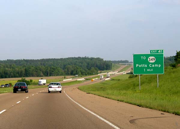
Access to Mount Pleasant via MS 311 north, MS 4 and MS 7 now bypass the downtown area of Holly Springs 30 MS 4 / MS 7 – Holly Springs, OxfordAccess to Senatobia via MS 7 37 Lake Center Potts Camp 41  To MS 349 – Potts Camp
Benton Hickory Flat 48  MS 178 – Hickory Flat
Access to MS 2 and MS 5 Union Myrtle 55 Myrtle New Albany 60 Glenfield This is a connector to MS30 and to a Wal-Mart distribution center 61  MS 30 west – West New Albany, Oxford
West end of MS 30 overlap 63 Downtown New Albany 64  MS 15 / MS 30 east – Pontotoc, Ripley
East end of MS 30 overlap 73  MS 9 north – Blue Springs
West end of MS 9 overlap and service to a new Toyota plant opening in 2011 Pontotoc Sherman 76 MS 9 south (MS 178) – Sherman, PontotocEast end of MS 9 overlap and accesses the new Toyota plant Lee Tupelo 81 MS 178 (McCullough Boulevard) – West Tupelo85  Natchez Trace Parkway
86  US 45 (Corridor V west) – Tupelo, Corinth
West end of Corridor V overlap; signed as exits 86A (south) and 86B (north) 87 Veterans Boulevard Access to Elvis Presley birthplace 90 Auburn Road 94  MS 371 – Mantachie, Mooreville
Itawamba 97 Fawn Grove Road – Dorsey 101  MS 178 / MS 363 – Peppertown, Mantachie
Due to the Tenn-Tom waterway MS-178 ends on the west bank of the waterway opposite Fulton Fulton 104  MS 25 south – Fulton, Amory
West end of MS 25 overlap, MS 178 resumes eastbound in downtown Fulton. 108 MS 25 north (Corridor V east) – Belmont, IukaEast end of MS 25/Corridor V overlap; west end of Corridor X overlap Tremont 113  MS 23 – Tremont, Smithville
MS 178 terminates eastbound at intersection with MS 23 just north of Corridor X Alabama
County Location # Destinations Notes Marion 3  CR-33
CR-33Bexar Hamilton 7 Weston, Hamilton (SR 74) Provides access to US 278 east and to Al 19 Red Bay 11  SR-17 – Hamilton, Sulligent
Also connects to AL-19 14 Hamilton (CR-35) 16 
 US-43 / US-278 (SR-171) – Hamilton, Guin
22  CR-45
CR-4526  SR-44 – Brilliant, Guin
Also serves the community of Twin Winfield 30  SR-129 – Brilliant, Winfield
34  SR-233 – Glen Allen, Natural Bridge
Walker 40  SR-13 – Natural Bridge, Eldridge
Also access to Fayette and Tuscaloosa via AL 13 South Carbon Hill 46  CR-11 – Carbon Hill, Nauvoo
52  SR-118 – Carbon Hill
53 (no name) Future AL 102 Jasper 57 SR-118 east – Jasper96  SR-69 – Jasper, Tuscaloosa
Old exit 96 101  SR-269 – Jasper, Parrish
Old exit 101 104 Industrial Parkway Road – Jasper Old exit 104 70  CR-22 – Cordova, Parrish
72  CR-61 – Cordova
78  CR-81 – Dora, Sumiton
Jefferson 81  CR-45 – West Jefferson
Alabama Power Miller Steam Plant access (coal fired facility) Graysville 85  US-78 – Birmingham, Adamsville, Graysville
 SR-5 – Sumiton, Dora
87  CR-112 – Graysville
Forestdale 89  CR-65 – Adamsville, Graysville
Hillcrest Road/Minor Parkway 91  CR-105 – Brookside
Cherry Avenue & Forestdale 93  CR-77 – Coalburg
Directional signs on exit ramp notate north to Coalburg and south to Birmingham Birmingham 95 I-65, HuntsvilleThis exit began construction in October 2010 with a scheduled completion sometime in either 2013 or 2014 References
- ^ a b "Future Interstate 22 @ Interstate-Guide.com". Interstate Guide. http://www.interstate-guide.com/i-022.html. Retrieved 2008-02-15.
- ^ Google, Inc. Google Maps – Tentative Map of Future I-22 (Map). Cartography by Google, Inc. http://maps.google.com/maps?f=d&hl=en&geocode=1392346378167661835,34.992250,-89.877210%3B13767070516756336538,33.642320,-86.974850&saddr=US-78+E+%4034.992250,+-89.877210&daddr=33.593459,-86.940308&mra=dme&mrcr=0&mrsp=1&sz=11&sll=33.665497,-86.973953&sspn=0.258312,0.462799&ie=UTF8&ll=34.3389,-88.560791&spn=2.050119,3.702393&z=8. Retrieved 2008-02-15.
- ^ MacDonald, Ginny. "Next step toward I-22 up in the air". Birmingham News via al.com, February 21, 2010.
- ^ Rutherford, Joe. "Largest of I-22 corridor project nears start in Alabama". nems360.com, July 27, 2010.
- ^ a b McMurray, Jeffery (December 22, 2003). "Shelby's clout has helped put Corridor X on the brink of completion". The Associated Press State & Local Wire.
- ^ a b c d e "Corridor X opens new section; interchange lags". The Birmingham News: p. 2A. December 10, 2009.
- ^ a b c d "Interstate 69, Section of Independent Utility #9, Final Environmental Impact Statement". Mississippi Department of Transportation. June 28, 2006. p. 32. http://www.gomdot.com/Home/Projects/Studies/Northern/US78/pdf/ProjectInformation.pdf. Retrieved July 8, 2010.
- ^ MacDonald, Ginny (January 28, 2004). "Corridor X gets official seal as I-22". The Birmingham News.
- ^ a b MacDonald, Ginny (April 15, 2005). "Corridor X becomes I-22: Signs bearing name to be unveiled Monday in Jasper by officials". The Birmingham News: p. 1C.
- ^ Faulk, Kent (November 23, 2005). "Corridor X section opens in west Alabama". The Birmingham News: p. 4C.
- ^ MacDonald, Ginny (June 2, 2007). "13 miles of Corridor X to open: End of long road in sight for I-22". The Birmingham News: p. 1A.
- ^ MacDonald, Ginny (October 31, 2007). "26 miles of Corridor X to open Nov. 14: Stretch offers straight shot from Forestdale to Memphis". The Birmingham News: p. 1A.
- ^ a b "Alabama's highway system keeps improving". The Birmingham News: p. 1B. December 21, 2009.
- ^ a b c Gray, Jeremy (July 26, 2010). "Birmingham I-65/Corridor X project set to launch August 1". The Birmingham News. http://blog.al.com/spotnews/2010/07/birmingham_i-65corridor_x_proj.html. Retrieved July 26, 2010.
- ^ MacDonald, Ginny (November 26, 2006). "Roads chief wants I-22 done by 2010: Corridor X connection and I-65 widening to begin next year". The Birmingham News: p. 1A.
- ^ Gray, Jeremy (May 21, 2010). "Alabama Department of Transportation opens bids on Corridor X link to Interstate 65". The Birmingham News. http://blog.al.com/spotnews/2010/05/alabama_department_of_transpor_3.html. Retrieved May 22, 2010.
- ^ Gray, Jeremy (June 16, 2010). "Construction contract awarded for final link of Corridor X". The Birmingham News. http://blog.al.com/spotnews/2010/06/construction_contract_awarded.html. Retrieved June 21, 2010.
- ^ "Proposed US 78 Split Diamond Interchange, New Albany, MS". Mississippi Department of Transportation. July 19, 2007. http://www.gomdot.com/Home/Projects/Studies/Northern/US78/pdf/ProjectInformation.pdf. Retrieved July 8, 2010.
- ^ "Rest Areas and Welcome Centers". Mississippi Department of Transportation. http://gomdot.com/Home/Travel/RAWC/Home.aspx. Retrieved July 8, 2010.
- ^ a b MacDonald, Ginny (May 26, 2009). "Corridor X/ I-65 interchange construction could begin this year". The Birmingham News. http://www.al.com/news/birminghamnews/metro.ssf?/base/news/1243325715144810.xml&coll=0. Retrieved May 26, 2009.
External links
Main Interstate Highways (major interstates highlighted)
4 5 8 10 12 15 16 17 19 20 22 24 25 26 27 29 30 35 37 39 40 43 44 45 49 55 57 59 64 65 66 68 69 70 71 72 73 74 75 76 (W) 76 (E) 77 78 79 80 81 82 83 84 (W) 84 (E) 85 86 (W) 86 (E) 87 88 (W) 88 (E) 89 90 91 93 94 95 96 97 99 H-1 H-2 H-3 Unsigned A-1 A-2 A-3 A-4 PRI-1 PRI-2 PRI-3 Lists Primary Main - Intrastate - Suffixed - Temporary - Future - Gaps Auxiliary Main - Future - Unsigned Other Standards - Business - Bypassed - Tolled Major highways of Greater Birmingham I-20 • I-59 • I-459 • I-65 • US 11 (Bessemer/Gadsden) • US 31 (Decatur/Montgomery) • US 78 (Bankhead/Crestwood) • US 280 • Red Mountain Expressway • Lakeshore Parkway • Future I-22 • I-422Interstate Highways in Alabama Current Future 22 • 422Former Browse numbered routes ←  MS 21
MS 21MS MS 22  →
→←  SR-21
SR-21AL SR-22  →Categories:
- Interstate Highways in Alabama
- Interstate Highways in Mississippi
- Appalachian Development Highway System
- Proposed Interstate Highways


Wikimedia Foundation. 2010.