- Sulligent, Alabama
Infobox Settlement
official_name = Sulligent, Alabama
settlement_type =City
imagesize =
image_caption =
image_
imagesize =
image_caption =
image_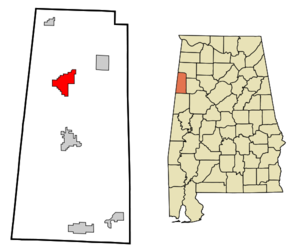
mapsize = 250px
map_caption = Location in Lamar County and the state ofAlabama
mapsize1 =
map_caption1 =
subdivision_type = Country
subdivision_type1 = State
subdivision_type2 = County
subdivision_name =United States
subdivision_name1 =Alabama
subdivision_name2 = Lamar
government_type =
leader_title =
leader_name =
established_date =
area_magnitude =
area_total_km2 = 20.3
area_total_sq_mi = 7.9
area_land_km2 = 20.3
area_land_sq_mi = 7.9
area_water_km2 = 0
area_water_sq_mi = 0
elevation_ft = 325
elevation_m = 99
population_as_of = 2000
population_footnotes =
population_total = 2151
population_metro =
population_density_km2 = 106
population_density_sq_mi = 272.3
timezone = Central (CST)
utc_offset = -6
latd = 33 |latm = 53 |lats = 41 |latNS = N
longd = 88 |longm = 7 |longs = 55 |longEW = W
timezone_DST = CDT
utc_offset_DST = -5
postal_code_type =ZIP code
postal_code = 35586
area_code = 205
blank_name = FIPS code
blank_info = 01-73728
blank1_name = GNIS feature ID
blank1_info = 0153600
footnotes =
website =Sulligent is a city in Lamar County,
Alabama ,United States . As of the2000 census, the population of the city is 2,151. The name is derived from railroad personae.History
Sulligent was first called "Elliott" named in honor of the chief engineer of the Kansas City-Memphis-Birmingham Railroad, renamed one month later, “Sulligent”, in honor of Sullivan, the superintendent of the railroad, and in honor of Sargeant, the passenger agent of the railroad.
The town was incorporated October
1887 .The production and processing of
cotton was an important industry.Notable residents
Sulligent is the birthplace of former
Auburn University and NFLrunning back Joe Cribbs .Geography
Sulligent is located at coor dms|33|53|41|N|88|7|55|W|city (33.894807, -88.131920)GR|1.
According to the
U.S. Census Bureau , the city has a total area of 7.8square mile s (20.3km² ), all of it land.US Route 278 (Main Street) passes through Sulligent, intersecting State Highway 17.
BNSF Railway provides railroad service with a line running east-west.Demographics
As of the
census GR|2 of 2000, there were 2,151 people, 901 households, and 637 families residing in the city. Thepopulation density was 273.9 people per square mile (105.8/km²). There were 1,029 housing units at an average density of 131.0/sq mi (50.6/km²). The racial makeup of the city was 77.08% White, 21.80% Black or African American, 0.60% from other races, and 0.51% from two or more races. 1.58% of the population were Hispanic or Latino of any race.There were 901 households out of which 29.2% had children under the age of 18 living with them, 52.9% were married couples living together, 13.7% had a female householder with no husband present, and 29.3% were non-families. 28.0% of all households were made up of individuals and 15.2% had someone living alone who was 65 years of age or older. The average household size was 2.39 and the average family size was 2.90.
In the city the population was spread out with 23.6% under the age of 18, 9.1% from 18 to 24, 26.8% from 25 to 44, 24.4% from 45 to 64, and 16.1% who were 65 years of age or older. The median age was 39 years. For every 100 females there were 87.2 males. For every 100 females age 18 and over, there were 84.2 males.
The median income for a household in the city was $26,541, and the median income for a family was $30,645. Males had a median income of $29,966 versus $19,537 for females. The
per capita income for the city was $15,794. About 18.0% of families and 21.0% of the population were below thepoverty line , including 22.7% of those under age 18 and 27.1% of those age 65 or over.References
External links
* [http://www.sulligent.siteblast.com/ Sulligent information]
Wikimedia Foundation. 2010.