- Interstate 82
-
This article is about the highway. For the video game, see Interstate '82.
Interstate 82

Interstate 82 highlighted in redRoute information Maintained by WSDOT and ODOT Length: 143.58 mi[2][3][4] (231.07 km) Existed: 1956[1] – present Major junctions West end: 
 I-90 / US 97 in Ellensburg, WA
 US 12 in Yakima, WA
US 97 near Yakima, WA
 I-182 / US 12 near Richland, WA
 US 395 near Kennewick, WA
 US 395 / US 730 in Umatilla, OR
East end: 
 I-84 / US 30 in Umatilla County, OR
Highway system Main route of the Interstate Highway System
Main • Auxiliary • Business←  OR 78
OR 78OR OR 82  →
→←  SR 41
SR 41WA I-90 →Interstate 82 (I-82) is a 143.58-mile (231.07 km) Interstate Highway that extends from I-90 in Ellensburg, Washington to I-84 near Umatilla, Oregon in the United States. In the state of Washington, it serves the cities of Ellensburg, Yakima, and the Tri Cities (via I-182), and in Oregon, it serves Umatilla and Hermiston. It is the major route westwards to Seattle and eastwards to Boise and Salt Lake City (via I-84 and I-15).[5][6][7][8] I-82's designation is a violation of the Interstate system's numbering rules, as it is located north of I-84, and is also primarily a north-south route. I-84 was originally designated I-80N, but received its current number in 1980 as part of efforts to eliminate suffixed routes.[9][10]
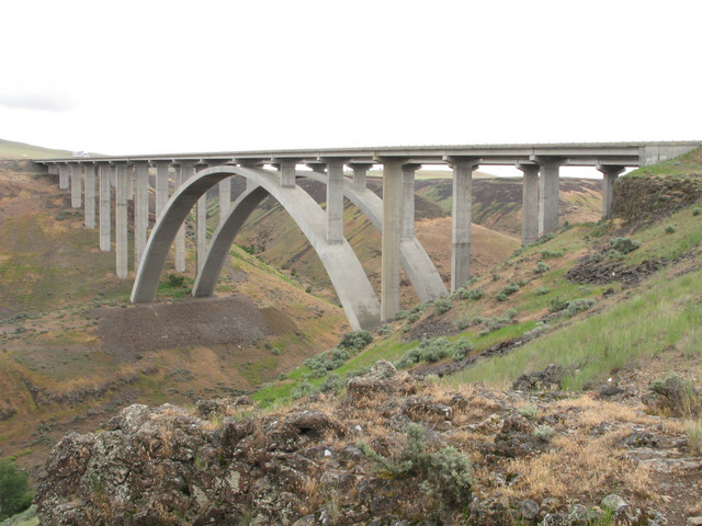
I-82 passes over Selah Creek on the Fred G. Redmon Bridge. When this bridge was opened on November 2, 1971 it was the longest concrete arch bridge in North America.[11][12] The bridge spans 549 feet (167 m) long across the creek.[11][12] In 1999, a plan surfaced to extend the Interstate down south through Oregon. Three routes were proposed but all were rejected.[13][14]
Contents
Route description
Lengths mi km WA 132.57[3] 213.35 OR 11.01[4] 17.72 Total 143.58[2] 231.07 I-82 starts at an interchange with I-90 and U.S. Route 97 (US 97) in Ellensburg.[15] At this point, I-82/US 97 start heading southeast towards Yakima. Before entering Yakima, I-82/US 97 intersects State Route 821 (SR 821) and State Route 823 (SR 823) while passing the Yakima Firing Center.

Just north of Selah, the freeway passes over Selah Creek on the Fred G. Redmon Bridge, the longest concrete arch in North America at the time of its opening, spanning 549 feet (167 m) long across the creek.[11][12] From the bridge, I-82/US 97 passes from Selah into Yakima.[15] In Yakima, I-82/US 97 join US 12 and intersect SR 24.[15] After leaving Yakima and Union Gap, US 97 splits from I-82/US 12. I-82 then enters the Yakama Indian Reservation as it starts turning eastward towards the Tri-Cities. West of Toppenish, I-82/US 12 intersects SR 22, and then goes east past Zillah and into Granger, where it intersects SR 223.[16][17][18][19]
After leaving both Granger and the Yakima Indian Reservation, the freeway continues east to Sunnyside, where the highway intersects SR 241. Then, I-82/US 12 turns southeast to pass Grandview and reach Prosser, where SR 22 intersects the freeway.[15] From Prosser, the highway turns northeast into Benton City, where SR 224 and SR 225 intersect I-82/US 12. From Benton City, the freeway goes eastward towards Richland, when I-182 starts and US 12 joins I-182 into Richland.[20] From the interchange, I-82 goes southeast around the Tri-Cities and joins US 395.[21] After joining US 395, the freeway goes south and then west into Plymouth, where the highway intersects SR 14 and leaves Washington on the Umatilla Bridge over the Columbia River heading into Oregon.[15][22] [23]
After coming off the bridge, I-82/US 395 enter Umatilla, where US 395 exits off at the intersection with US 730. After leaving Umatilla, the highway goes southwest and passes the Umatilla Ordnance Depot before ending at I-84/US 30 southwest of Hermiston.[24][25][26]
History
 The shield of Primary State Highway 3.
As part of Washington's first connected state highway system, the Washington State Legislature designated the Inland Empire Highway between Ellensburg and Laurier in 1913.[27] The State Highway Board selected a route that would connect the main cities of Eastern Washington and the Inland Empire, which were Ellensburg, Yakima, the Tri Cities, Colfax, and Spokane.[28][29] In 1923, by which time the entire road had been improved,[30] the highway became State Road 3 (Primary State Highway 3 and Primary State Highway 3 WA after 1937), but retained its name.[31] By that time, most of the route of Interstate 82 became parts of US 410, US 97, and US 395, all three were established in 1926.[32][33][34]
In 1956, President Dwight D. Eisenhower signed the Federal-Aid Highway Act of 1956, which started the construction of Interstate Highways.[35][36] Even though I-82 was designated in 1956, construction did not start until the early 1980s, and the last section of Interstate 82 within Washington opened in 1987.[37] Legally, the Washington section of I-82 is defined at Washington Revised Code § 47.17.135.[1] Several projects are currently ongoing and have been completed in the recent years on I-82.[38]
I-82 was meant to go from Tacoma, across Naches Pass, and then southeast into Yakima and the Tri-Cities.[not in citation given] The proposal was quickly denied and later resurfaced as the SR 168 Proposal.[39]
The original plans for the included two options. One was the current route (which was opposed by the Tri-Cities), and another had I-82 go from Prosser into Richland and Pasco, and then southeast to Wallula and then end at I-80N (present-day I-84) in Pendleton. The first option was chosen, but the Tri-Cities needed access, so the Federal Highway Administration created Interstate 182, which would serve as a connector from I-82 to the Tri-Cities.[40][41] [42]
When I-80N was renumbered I-84 in 1980, I-82's designation became a violation of the Interstate system's numbering rules, as it was now located north of I-84. The reason for the renumbering was a change in guidelines published by the American Association of State Highway and Transportation Officials that advised renumbering suffixed routes.[9][10] In 1999, a plan surfaced to extend I-82 further south in Oregon. Three major routes were proposed including the Madras Route, from Umatilla through Heppner, Condon, Fossil, and Antelope to Madras, where I-82 would replace US 97 south through Bend to the California border, the Prineville route, from Umatilla through Heppner, Hardman, Spray, Prineville, and Powell Butte to US 97 near Bend, then continue south to the border, and the US 395 route, from Umatilla through John Day, Burns, and Lakeview, presumably to the California border and beyond.[13][14]
Exit list
County Location Mile[3][4] # Destinations Notes Kittitas 0.00 I-90 / US 97 north – Spokane, SeattleWestbound exit and eastbound entrance 3.22 3  SR 821 south (Thrall Road)
11.62 11 Yakima Training Center Yakima 26.56 26  SR 821 north (Canyon Road) to SR 823 – Selah
28.99 29 East Selah Road 30.59 30 SR 823 north / Rest Haven Road – SelahSigned as exits 30A (SR 823) and 30B (Rest Haven Road) westbound Yakima 31.35 31 US 12 west / North 1st Street – Naches, White PassWest end of US 12 overlap; signed as exits 31A (US 12) and 31B (1st Street) eastbound 33.21 33A Fair Avenue, Lincoln Avenue Eastbound exit and entrance 33.21 33B Yakima Avenue – Terrace Heights Signed as exit 33 westbound 34.74 34  SR 24 east / Nob Hill Boulevard – Moxee
Union Gap 36.26 36 Valley Mall Boulevard – Union Gap 37.81 37 US 97 south – Goldendale, BendEast end of US 97 overlap; eastbound exit and westbound entrance 38.07 38 Union Gap Westbound exit and eastbound entrance 40.31 40 Thorp Road, Parker Road 44.29 44 Wapato 50.08 50  SR 22 east – Toppenish, Buena
Zillah 52.05 52 Zillah, Toppenish 54.05 54 Division Road – Zillah Granger 58.47 58  SR 223 south – Granger
Sunnyside 63.61 63 Sunnyside, Outlook 66.90 67 Sunnyside, Mabton 68.91 69  SR 241 Waneta Road – Sunnyside, Mabton
Grandview 72.58 73 Stover Road – Grandview 75.02 75 County Line Road – Grandview Benton Prosser 79.90 80 Gap Road – Prosser 82.31 82  SR 22 to SR 221 – Mabton, Paterson
88.52 88 Gibbon Road 93.58 93 Yakitat Road Benton City 96.55 96 
 SR 224 north / SR 225 – West Richland, Benton City
102.48 102 I-182 east / US 12 east – Richland, PascoEast end of US 12 overlap 104.49 104 Dallas Road 108.91 109 Badger Road 112.76 113 US 395 north to I-182 – Kennewick, Pasco, SpokaneWest end of US 395 overlap 114.36 114 Locust Grove Road (I-82 to SR 397 Intertie) 122.70 122 Coffin Road 131.55 131  SR 14 west – Plymouth, Vancouver
132.57
0.00Washington / Oregon state line Umatilla Umatilla 1.00 1 US 395 south / US 730 – Umatilla, Hermiston, IrrigonEast end of US 395 overlap 4.83 5 Power Line Road 9.79 10 Westland Road 11.21 I-84 / US 30 – Portland, PendletonEastbound exit and westbound entrance Auxiliary routes
References
- ^ a b Washington State Legislature. "RCW 47.17.135: State route No. 82 — Washington green highway". http://apps.leg.wa.gov/RCW/default.aspx?cite=47.17.135. Retrieved 2008-08-10.
- ^ a b Federal Highway Administration (2002-10-31). "Route Log and Finder List, Main Routes of the Dwight D. Eisenhower National System Of Interstate and Defense Highways". http://www.fhwa.dot.gov/reports/routefinder/table1.htm. Retrieved 2008-08-27.
- ^ a b c Washington State Department of Transportation (2006). "State Highway Log" (PDF). http://www.wsdot.wa.gov/mapsdata/TDO/PDF_and_ZIP_Files/HwyLog2006.pdf. Retrieved 2008-08-27.
- ^ a b c Oregon Department of Transportation. "Public Road Inventory". http://www.oregon.gov/ODOT/TD/TDATA/rics/PublicRoadsInventory.shtml. Retrieved 2008-08-27.
- ^ Google, Inc. Google Maps – overview map of I-82 (Map). Cartography by Google, Inc. http://maps.google.com/maps?f=d&saddr=I-82+W%2FUS-395+N+%4045.931720,+-119.328370&daddr=46.970999,-120.511265&hl=en&geocode=6148851770216159538,45.931720,-119.328370&mra=mi&mrsp=1,0&sz=14&sll=46.967485,-120.514698&sspn=0.017747,0.035706&ie=UTF8&ll=46.452997,-120.135498&spn=2.293271,4.570312&z=7. Retrieved 2008-08-22.
- ^ Washington State Department of Transportation (2008) (PDF). Official State Highway Map (Map). 1:842,000. Official State Highway Maps. Cartography by U.S. Geological Survey (2008-2009 ed.). Olympia, Washington. http://www.wsdot.wa.gov/NR/rdonlyres/87105CAD-83A9-49A7-80F3-5719637C1E2D/0/FrontMapBig.pdf. Retrieved 2008-08-07.
- ^ GM Johnson (2007). Washington Large Print (Map). GM Johnson Large Print State Maps (2007 ed.). Burnaby, British Columbia. http://store.maplink.com/map.aspx?nav=MS&cid=10056,10078&pid=538387. Retrieved 2008-08-08.
- ^ GM Johnson (2007). Oregon Large Print (Map). GM Johnson Large Print State Maps (2007 ed.). Burnaby, British Columbia. http://store.maplink.com/map.aspx?nav=MS&cid=10056,10078&pid=533003. Retrieved 2008-08-08.
- ^ a b "Highway Resolutions - Interstate 84". Utah Department of Transportation. http://www.dot.utah.gov/main/uconowner.gf?n=200609181109591. Retrieved 2008-05-18.
- ^ a b "Interstate 80 to become 84". Deseret News. 1977-08-13. pp. A3. http://news.google.com/newspapers?id=GAIPAAAAIBAJ&sjid=b38DAAAAIBAJ&pg=4293,3376681&dq=interstate-84+80n+utah. Retrieved 2008-09-21.[dead link]
- ^ a b c HistoryLink (2005-03-07). "Fred Redmon Bridge (Selah Creek Bridge) opens on November 2, 1971". http://historylink.org/index.cfm?DisplayPage=output.cfm&File_Id=7268. Retrieved 2008-08-27.
- ^ a b c Washington State Department of Transportation. "WSDOT - History of WSDOT (1978-1990)". http://www.wsdot.wa.gov/Centennial/1961-1977.htm. Retrieved 2008-09-09.
- ^ a b Sinks, James. "Eastern Oregon waits for new highway". The Bulletin (The Bulletin).
- ^ a b Oregon Department of Transportation. "Interstate 50th Anniversary: The Story of Oregon’s Interstates" (PDF). http://www.oregon.gov/ODOT/COMM/docs/Oregon_Interstate_Background.pdf. Retrieved 2008-08-24.
- ^ a b c d e Rand McNally (2008). The Road Atlas (Map). p. 108. ISBN 0528939610.
- ^ Google, Inc. Google Maps – overview map of I-82 (Ellensurg to Granger) (Map). Cartography by Google, Inc. http://maps.google.com/maps?f=d&saddr=Exit+110+%4046.963535,+-120.507446&daddr=46.345772,-120.178049&hl=en&geocode=917336435896704481,46.963535,-120.507446&mra=mi&mrsp=1,0&sz=17&sll=46.346069,-120.177984&sspn=0.002244,0.004463&ie=UTF8&ll=46.672056,-120.454102&spn=1.142049,2.285156&z=8. Retrieved 2008-08-23.
- ^ Rand McNally (2008). The Road Atlas (Map). p. 108, section K12. ISBN 0528939610.
- ^ GM Johnson (2008). Yakima, Yakima County Wineries (Map). City Street Map (2008 ed.). Burnaby, British Columbia. http://store.maplink.com/map.aspx?nav=MS&cid=10056,10078&pid=523006. Retrieved 2008-08-08.
- ^ Washington State Department of Transportation. "WSDOT Interchange Viewer - Interstate 82 (Exit 3 to 54)". http://www.wsdot.wa.gov/Traffic/InterstateGuide/I82_EllensbToEZillah.htm. Retrieved 2008-08-10.
- ^ Rand McNally (2008). The Road Atlas (Map). p. 108, section K14. ISBN 0528939610.
- ^ GM Johnson (2007). Tri-Cities, Kennewick, Pasco, Richland (Map). City Street Map (2007 ed.). Burnaby, British Columbia. http://store.maplink.com/map.aspx?nav=MS&cid=10056,10078&pid=522990. Retrieved 2008-08-08.
- ^ Google, Inc. Google Maps – overview map of I-82 (Granger to Plymouth) (Map). Cartography by Google, Inc. http://maps.google.com/maps?f=d&saddr=I-82+E+%4046.345763,+-120.178062&daddr=45.93164,-119.328743&hl=en&geocode=6918350065108018922,46.345763,-120.178062&mra=mi&mrsp=1&sz=18&sll=45.931707,-119.328942&sspn=0.001131,0.002232&ie=UTF8&ll=46.185535,-119.679565&spn=0.576153,1.142578&z=9. Retrieved 2008-08-23.
- ^ Washington State Department of Transportation. "WSDOT Interchange Viewer - Interstate 82 (Exit 58-131)". http://www.wsdot.wa.gov/Traffic/InterstateGuide/i82/I82_GrangerToOreBorder.htm. Retrieved 2008-08-10.
- ^ Google, Inc. Google Maps – overview map of I-82 (Umatilla to Hermiston) (Map). Cartography by Google, Inc. http://maps.google.com/maps?f=d&saddr=I-82+E%2FUS-395+S+%4045.931640,+-119.328730&daddr=45.798618,-119.39096&hl=en&geocode=2070871501223100006,45.931640,-119.328730%3B10765069594133851846,45.798461,-119.391166&mra=dme&mrcr=0&mrsp=1&sz=15&sll=45.796913,-119.391217&sspn=0.009066,0.017853&ie=UTF8&ll=45.863238,-119.369888&spn=0.144882,0.285645&z=11. Retrieved 2008-08-23.
- ^ Rand McNally (2008). The Road Atlas (Map). p. 84, section C11. ISBN 0528939610.
- ^ GM Johnson (2008). Walla Walla, Hermiston, Pendleton (Map). City Street Map (2008 ed.). Burnaby, British Columbia. http://store.maplink.com/map.aspx?nav=MS&cid=10056,10078&pid=523000. Retrieved 2008-08-08.
- ^ Washington State Legislature (1913) [1913]. "65". Session Laws of the State of Washington. Session Laws of the State of Washington (1913 ed.). Olympia, Washington: Washington State Legislature. pp. 221. http://books.google.com/?id=W7w4AAAAIAAJ. Retrieved 2008-08-10.
- ^ State Highway Board (1912). Road Map of Washington Showing Main Traveled Roads (Map). http://www.secstate.wa.gov/history/maps_detail.aspx?m=33. Retrieved 2008-08-26.
- ^ State Highway Board. Map of Washington State Highways Authorized by Legislative Acts of 1913 (with 1915 changes marked) (Map). http://content.wsulibs.wsu.edu/cgi-bin/viewer.exe?CISOROOT=/maps&CISOPTR=755. Retrieved 2008-08-26.
- ^ Rand McNally. Official 1923 Auto Trails Map, District No. 14: Washington, Oregon, Northern California, Western Idaho (Map). http://www.usautotrails.com/MultistatePage/1923RandMcNallyATWAandORPage/image1.html. Retrieved 2008-08-26.
- ^ Washington State Legislature (1923) [1923]. "185". Session Laws of the State of Washington. Session Laws of the State of Washington (1923 ed.). Olympia, Washington: Washington State Legislature. pp. 627–628. http://books.google.com/?id=G784AAAAIAAJ. Retrieved 2008-08-10.
- ^ United States Department of Agriculture (1926-11-11). Final 1926 Plan of the U.S. Highway System (Map). http://upload.wikimedia.org/wikipedia/commons/5/55/1926us.jpg. Retrieved 2008-08-10.
- ^ Department of Highways (1933-04-01). Highway Map: State of Washington (Map). http://www.secstate.wa.gov/history/maps_detail.aspx?m=70. Retrieved 2008-08-26.
- ^ Department of Highways (1939). Highways of the State of Washington (Map). http://www.secstate.wa.gov/history/maps_detail.aspx?m=28. Retrieved 2008-08-26.
- ^ United States Department of Transportation/Federal Highway Administration (2006-07-07). "The Greatest Decade 1956-1966 Part 1 Essential to the National Interest". http://www.fhwa.dot.gov/infrastructure/50interstate.cfm. Retrieved 2008-08-11.
- ^ United States Department of Transportation/Federal Highway Administration. "History of the Interstate Highway System". http://www.fhwa.dot.gov/interstate/history.htm. Retrieved 2008-08-11.
- ^ Washington State Department of Transportation. "WSDOT - History of WSDOT (1978-1990)". http://www.wsdot.wa.gov/Centennial/1978-1990.htm. Retrieved 2008-08-11.
- ^ Washington State Department of Transportation. "WSDOT - Construction Projects on Interstate 82". http://www.wsdot.wa.gov/Projects/I82/. Retrieved 2008-08-11.
- ^ Washington State Legislature. "RCW 47.17.335: State route No. 168". http://apps.leg.wa.gov/RCW/default.aspx?cite=47.17.335. Retrieved 2008-09-09.
- ^ United States Department of Transportation and Federal Highway Administration (1963). Interstate Highway System (1963) (Map). http://upload.wikimedia.org/wikipedia/commons/7/70/Interstate_Highway_status_unknown_date.jpg. Retrieved 2008-09-09.
- ^ United States Department of Transportation and Federal Highway Administration (1970-10-01). Interstate Highway System (1970) (Map). http://upload.wikimedia.org/wikipedia/commons/e/e7/Interstate_Highway_plan_October_1%2C_1970.jpg. Retrieved 2008-09-09.
- ^ United States Department of Transportation and Federal Highway Administration (1976-09-30). Interstate Highway System (1976) (Map). http://upload.wikimedia.org/wikipedia/commons/a/ac/Interstate_Highway_status_September_30%2C_1976.jpg. Retrieved 2008-09-09.
External links
Main Interstate Highways (major interstates highlighted)
4 5 8 10 12 15 16 17 19 20 22 24 25 26 27 29 30 35 37 39 40 43 44 45 49 55 57 59 64 65 66 68 69 70 71 72 73 74 75 76 (W) 76 (E) 77 78 79 80 81 82 83 84 (W) 84 (E) 85 86 (W) 86 (E) 87 88 (W) 88 (E) 89 90 91 93 94 95 96 97 99 H-1 H-2 H-3 Unsigned A-1 A-2 A-3 A-4 PRI-1 PRI-2 PRI-3 Lists Primary Main - Intrastate - Suffixed - Temporary - Future - Gaps Auxiliary Main - Future - Unsigned Other Standards - Business - Bypassed - Tolled Interstate Highways in Oregon Current Cancelled Interstate Highways in Washington Current Proposed State highways in Washington related to I-82  SR 821 - SR 823
Benton County Highways Interstates  I-82 • I-182
U.S. Highways State Highways Categories:- Interstate Highway System
- Interstate Highways in Oregon
- Interstate Highways in Washington (state)
- Transportation in Kittitas County, Washington
- Transportation in Yakima County, Washington
- Transportation in Benton County, Washington
- Transportation in Umatilla County, Oregon


Wikimedia Foundation. 2010.