- Interstate 90 in Washington
-
This article is about the section of Interstate 90 in Washington. For the entire length of the highway, see Interstate 90.
Interstate 90

Interstate 90 is highlighted in red.Route information Maintained by WSDOT Length: 296.92 mi[1][2] (477.85 km) Major junctions West end: 
 I-5 / SR 519 in Seattle
 I-405 in Bellevue
 US 97 near Ellensburg
 I-82 / US 97 near Ellensburg
 US 395 near Ritzville
 US 2 near Spokane
 US 195 in Spokane
US 2 / US 395 in SpokaneEast end:  I-90 at Idaho state line
Highway system Main route of the Interstate Highway System
Main • Auxiliary • BusinessState highways in Washington
Interstate • US • State
Former PSH • 1964 renumbering • Former SR← I-82SR 92  →
→Interstate 90 (I-90), a transcontinental Interstate Highway from Seattle, Washington, to Boston, Massachusetts, crosses the state of Washington before crossing the Idaho state line between Spokane and Post Falls. It serves the cities of Seattle, Bellevue, Issaquah, Ellensburg, Moses Lake, Ritzville, and Spokane.[3][4]
It is the only Interstate Highway to cross the state east to west, but there are two U.S. Routes that also do the same, U.S. Route 2 and U.S. Route 12, along with a few state highways.[5][6] I-90 is also the only highway in Washington to connect the two largest cities in the state (Seattle and Spokane).[7][8] The road is the third busiest in the state, behind I-5 at 240,000[9] and I-405 at 201,000.[9] An estimated 148,000 motorists use the road daily.[9]
I-90 incorporates two of the longest floating bridges in the world, the Lacey V. Murrow Memorial Bridge and the Homer M. Hadley Memorial Bridge, which cross Lake Washington from Seattle to Mercer Island, Washington. They are the second- and fifth-longest such bridges, respectively.
Contents
Route description
Seattle to Snoqualmie Pass
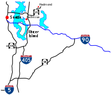 I-90 in Seattle and Vicinity
Interstate 90 starts at the merging of onramps from 4th Avenue S. and Edgar Martínez Drive S. (formerly S. Atlantic Street) south of Downtown Seattle. The recently rebuilt freeway joins the I-90 Express Lanes and goes east to an interchange with I-5. After leaving the interchange, the highway travels through the Central Area and into the Mount Baker Tunnel, a tunnel on the National Register of Historic Places[10] that carries I-90 and its express lanes under the Mount Baker neighborhood. After emerging from the eastern portal of the tunnel, I-90 splits and the eastbound lanes go on the Lacey V. Murrow Memorial Bridge and the westbound lanes exit off the Homer M. Hadley Memorial Bridge, which is shared with the I-90 express lanes, both over Lake Washington.[11]
After crossing Lake Washington, I-90 enters Mercer Island and goes under the Mercer Island Lid at West Mercer Way and emerges at 76th Avenue SE before[12] leaving Mercer Island to cross over Lake Washington again on the shorter East Channel Bridge into Eastside. Once in Eastside, the highway enters Bellevue and travels east to Bellevue Way, where the express lanes merge with I-90 or keep going to exit off to I-405.
After leaving a stack interchange with I-405 north of the Factoria Mall, the freeway passes Bellevue College, Lake Sammamish, and Lake Sammamish State Park before entering Issaquah and intersecting SR 900.[13][14]
After passing by downtown Issaquah, the highway goes along the northern boundary of the Tiger Mountain State Forest and passes Preston, where the speed limit raises from 60 MPH to 70 MPH, before intersecting SR 18 in Upper Preston. From Upper Preston, I-90 passes Echo Lake and Snoqualmie before entering North Bend, where SR 202 begins after an interchange with the highway.[15][16][17][18]
Seattle-Bellevue Express Lanes
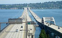 I-90 and its express lanes (middle) go east across Lake Washington on the Lacey V. Murrow Memorial Bridge and Homer M. Hadley Memorial Bridge.
Interstate 90 has a 7.45-mile (11.99 km) long[2] reversible express lane that go across Lake Washington from Seattle to Bellevue. The express lane starts at two different locations, one at the southern terminus of the Downtown Seattle Transit Tunnel and the other at a signalled intersection at 5th Avenue S., S. Dearborn Street, and Airport Way S. The lanes turn east and travel in a separated right-of-way before traveling towards the middle of I-90 east of the interchange with I-5. This section is bi-directional, containing two lanes separated by a barrier, and allows buses to use the lanes in both directions at all times. From there, the lanes travel through the Mount Baker Tunnel and onto the Homer M. Hadley Memorial Bridge, sharing the bridge with the westbound lanes. From there, the lanes travel through Mercer Island and ends at its terminus with the I-90 interchange with Bellevue Way, with ramps connecting to mainline I-90 and I-405.[11][13][19][20]
Segments of the express lanes between the western terminus to I-90 ramps and Island Crest Way and the eastern terminus are reserved for HOV only. The westbound traffic uses the express lanes from 1 am to 12:30 pm (Monday – Friday) The eastbound traffic uses the express lanes from 2 pm to 12 midnight (Monday – Friday) and all day from Saturday to Sunday. The express lanes are closed every other Tuesday from 10 am to 1:30 pm.[21]
Snoqualmie Pass to Ritzville

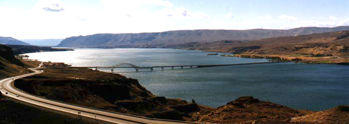
Forty-two miles east of Bellevue, at milepost 53, I-90 traverses the Cascade Mountains via Snoqualmie Pass, elevation 3,022 feet (921 m), the only interstate crossing and second-lowest east–west crossing in Washington State.[22] I-90 then goes out towards the Columbia Plateau, passing through the cities of Cle Elum and Ellensburg. It crosses the Columbia River on the Vantage Bridge. After passing in to Grant County, North Frontage Road and South Frontage Road parallel I-90 through Grant County. The frontage roads intersect each exit off I-90 (Exits 143 to 174 and Exits 179 to 184. In Moses Lake at Exit 174, the frontage roads end. The freeway passes through Moses Lake. The frontage roads begin again at Exit 179 in Moses Lake and end at the Adams County line.[16][18][23][24][25]
Ritzville to Idaho
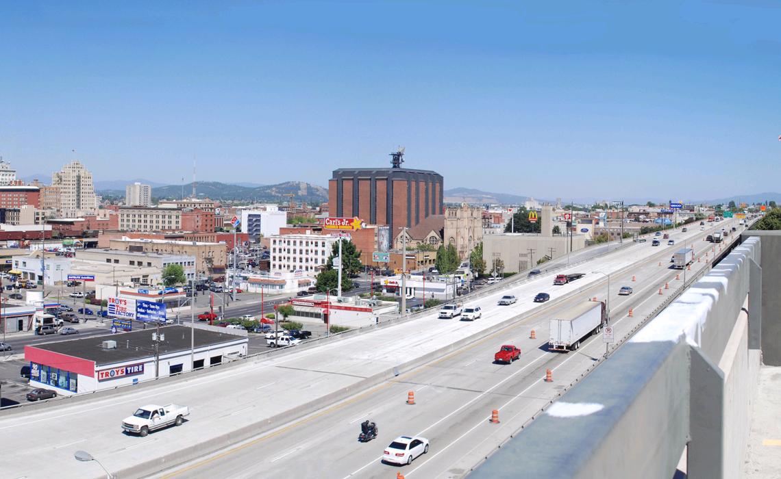
 I-90 as seen from the parking lot of Deaconess Medical Center in Spokane.
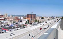
At Ritzville, I-90 forms a concurrency with US 395 towards Spokane, where US 2 also forms a concurrency and both US 395 and US 2 branch off from I-90 at Downtown Spokane. I-90 continues to head east through the suburbs of Spokane and into Idaho.[16][26][27][28][29][30][31]
History


The shields of Primary State Highways 2, 7, and 18. As part of the state's first connected state highway system, the Washington State Legislature designated the Sunset Highway between Seattle and Idaho in 1913.[32][33] Later in 1915, the Legislature also designated the North Central Highway between Ellensburg and Davenport.[32] The State Highway Board selected two routes that would partially connect the main cities of Western Washington to Eastern Washington and Idaho.[34][35] In 1923, by which time the entire road had been improved and a new connection had filled in a small gap,[36] the Sunset Highway became State Road 2 (Primary State Highway 2 after 1937), but retained its name.[37] The North Central Highway became State Road 7 (Primary State Highway 7 after 1937), but retained its name.[37] Another highway, named Primary State Highway 18 between George and Ritzville.[38] By that time, most of the route of Interstate 90 became US 10, which was established in 1926.[39][40][41] Until 1940, the route headed south from Seattle to Renton, then east to Issaquah, in order to travel around Lake Washington.
Interstate 90 crosses Lake Washington between Seattle and Bellevue on a pair of floating bridges that are two of the world's longest floating bridges. The westbound lanes travel on the Homer M. Hadley Memorial Bridge, the fifth longest floating bridge, and the eastbound lanes travel on the Lacey V. Murrow Memorial Bridge, the second longest floating bridge. The Lacey V. Murrow Memorial Bridge, originally called the Lake Washington Floating Bridge, opened on July 2, 1940.[42] The bridge collapsed during construction on November 25, 1990. It was later rebuilt and the new bridge opened later in 1993.[43][44] The second bridge, the Homer M. Hadley Memorial Bridge, opened on June 4, 1989.[43]
 The new terminus of Interstate 90 after the first phase of the project.
Later in 1956, President Dwight D. Eisenhower signed the Federal-Aid Highway Act of 1956 which started the construction of Interstate Highways.[45][46] By 1969, US 10 was removed from the system entirely. During the construction of the freeway between Seattle and Bellevue, lawsuits were filed on May 28, 1970 and stopped construction of Interstate 90 until the early 1990s.[43][47] Legally, the Washington section of I-90 is defined at Washington Revised Code § 47.17.140.[48] In 1980, I-90 from Seattle to Thorp was designated the Mountains to Sound Greenway to protect its outstanding scenic and cultural resources.[49]
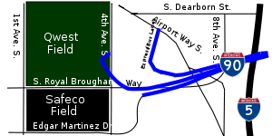
Before 2003, Interstate 90 used to end at a signalled intersection with 4th Avenue S. However, increasing traffic from Downtown Seattle, Colman Dock, Safeco Field, and Qwest Field forced city, county, and state officials to look for improvements to the area. The first stage of the improvements, the SR 519 South Seattle Intermodal Access Project, included the construction of a new on-ramp to Interstate 90 via a new interchange with 4th Avenue S. and Edgar Martínez Drive S. (formerly S. Atlantic Street). Other projects are currently ongoing and have been completed in the recent years on I-90.[50]
As part of Sound Transit's Phase 2 expansion project, the I-90 express lanes will be replaced with light rail tracks for the Link Light Rail East Link. Many have been concerned with this project because they fear that the loss of the express lanes will add more congestion onto the mainline. Despite those concerns, the project continues to move forward, with the construction of the replacement HOV lanes and direct-access ramps on the mainline.
Exit list
County Location Mile[2] # Destinations Notes King Seattle 0.00 Edgar Martinez Drive South, South Atlantic Street Westbound exit and eastbound entrance 0.00 SR 519 north / 4th Avenue South – Seattle City Center, Amtrak, Ferries, Safeco Field, Qwest FieldWestbound exit and eastbound entrance 0.32 2 I-5 – Vancouver, PortlandSigned as exits 2A (south) and 2B (north) eastbound and 2B (south) and 2C (north) westbound 1.39 3 Rainier Avenue Signed as exits 3A (south) and 3B (north) westbound; no westbound entrance 1.58 Express Lanes Eastbound exit and westbound entrance 2.13 Lacey V. Murrow Memorial Bridge over Lake Washington Mercer Island 4.09 6 West Mercer Way Eastbound exit and westbound entrance 4.91 7A 77th Avenue Southeast Eastbound exit and westbound entrance 5.17 7B Island Crest Way Signed as exit 7 westbound 6.38 Express Lanes Westbound exit and eastbound entrance 6.41 8 East Mercer Way 6.78 Homer M. Hadley Memorial Bridge over Lake Washington Bellevue 7.19 9 Bellevue Way 7.98 10A I-405 – Everett, RentonSigned as exit 10 westbound 8.23 10B Richards Road – Factoria Eastbound exit and westbound entrance 9.09 142nd Place Southeast HOV only 9.60 11B 148th Avenue Southeast – Bellevue College Westbound exit is via 156th Avenue 9.60 11A 150th Avenue Southeast, 156th Avenue Southeast Signed as exit 11 westbound 11 161st Avenue Southeast Eastbound exit is via 150th Avenue 11.73 13 West Lake Sammamish Parkway, Lakemont Boulevard Southeast, Southeast Newport Way Issaquah 13.89 15  SR 900 west (17th Avenue Northwest) – Renton
15.20 17 Front Street, East Lake Sammamish Parkway Southeast 16.13 18 East Sunset Way, Highlands Drive 18.32 20 High Point Way 20.59 22 Preston, Fall City 23.72 25  SR 18 west / Snoqualmie Parkway – Auburn, Tacoma
25.40 27 Snoqualmie, North Bend Eastbound exit and westbound entrance North Bend 28.63 31  SR 202 west – North Bend, Snoqualmie
30.95 32 436th Avenue Southeast 33.06 34 468th Avenue Southeast 36.14 38 (no name) Eastbound exit and westbound entrance 37.96 38 (no name) Westbound exit and eastbound entrance 40.68 42 Tinkham Road 43.91 45 USFS Road 9030 46.09 47 Denny Creek, Asahel Curtis Snoqualmie Pass 50.58 52 West Summit, Alpental Eastbound exit and westbound entrance Kittitas 51.29 53 East Summit, Snoqualmie Pass Recreational Area 53.03 54 Hyak, Gold Creek 61.30 62 Stampede Pass, Lake Kachess 62.31 63 Cabin Creek Road 68.63 70 Sparks Road – Easton 69.85 71 Easton 72.34 74 West Nelson Siding Road 76.35 78 Golf Course Road 78.60 80 Roslyn, Salmon la Sac Cle Elum 81.41-
82.4984 Cle Elum, South Cle Elum 84.15 85 
 SR 903 north / SR 970 – Cle Elum, Wenatchee
91.91 93 Elk Heights Road 99.36 101 Thorp Highway – Thorp 104.35 106 US 97 north – Ellensburg, WenatcheeWest end of US 97 overlap Ellensburg 107.65 109  I-90 Bus. (Canyon Road) – Ellensburg
109.15 110 I-82 east / US 97 south – YakimaEast end of US 97 overlap 113.76 115 Kittitas 134.72 136 Huntzinger Road – Vantage 135.72 Vantage Bridge over the Columbia River Grant 136.08 137 
 SR 26 east to SR 243 – Othello, Pullman, Richland
139.65 139 Scenic View 142.14 143 Silica Road 148.07 149  SR 281 north – Quincy, Wenatchee, George
150.02 151  SR 283 north / SR 281 north (via SR 281 Spur) – Ephrata, Soap Lake, Quincy, Wenatchee
152.90 154 Adams Road 162.88 164 Dodson Road 167.96 169 Hiawatha Road Moses Lake 172.89 174 Hansen Road – Mae Valley 173.69 175 Westshore Drive – Mae Valley Westbound exit only 174.28 176  I-90 Bus. east / SR 171 north – Moses Lake
177.74 179  SR 17 / I-90 Bus. west – Moses Lake, Ephrata, Othello
181.12 182 O Road Northeast/Southeast – Wheeler 183.18 184 Q Road Northeast/Southeast 187.18 188 U Road Northeast/Southeast – Warden Adams 195.20 196 Deal Road – Schrag 205.13 206  SR 21 – Lind, Odessa
213.52 215 Paha, Packard 218.21-
218.49220 US 395 south – Ritzville, PascoWest end of US 395 overlap 219.67 221  SR 261 south – Ritzville, Washtucna
224.14 226 Schoessler Road 228.95 231 Tokio Lincoln Sprague 242.98 245  SR 23 – Sprague, Harrington
251.74 254 Fishtrap Spokane 255.41 257  SR 904 east – Tyler, Cheney
262.02 264  SR 902 east – Cheney, Medical Lake
268.27 270 SR 904 west – Four Lakes, Cheney270.53 272 SR 902 west – Medical Lake274.04 276 I-90 Bus. east – Spokane, Geiger Field275.45 277B US 2 west – Spokane Airport, Fairchild AFB, DavenportWest end of US 2 overlap; signed as exit 277 westbound 275.92 277A Garden Springs Signed as exit 277 westbound; no entrance ramps Spokane 277.06 279 US 195 south – Colfax, Pullman277.88 280A Maple Street Signed as exit 280 eastbound 280B Lincoln Street Eastbound exit is via exit 280 279.05 281 US 2 east / US 395 north (Division Street) – Newport, ColvilleEast end of US 2/US 395 overlap 279.83 282A  SR 290 east (Trent Avenue) / Hamilton Street
Signed as exit 282 eastbound 280.08 282B Second Avenue Westbound exit only 280.74 283A Altamont Street 281.44 283B Thor Street, Freya Street 282.05 Havana Street Eastbound entrance only Spokane Valley 283.32 285 Sprague Avenue No eastbound entrance 283.95 286 Broadway Avenue 285.54 287 Argonne Road 287.56 289  SR 27 (Pines Road)
288.74 291A Evergreen Road – Spokane Valley Mall 289.62 291B Sullivan Road 291.66 293 Barker Road Liberty Lake 292.63 294 Country Vista Drive, Appleway Avenue Westbound exit and eastbound entrance 293.89 296 Liberty Lake, Otis Orchards 297.20 299 State Line, Idaho 297.52 Idaho state line Reversible express lanes
County Location Mile # Destinations Notes King Seattle 1.99 Airport Way South, South Dearborn Street HOV entrance/exit only 2.21 Downtown Seattle Transit Tunnel Bus only 3.21 Rainier Freeway Station Bus only 3.66  I-90 west to I-5
Westbound off-ramp only (All Mercer Island SOVs exit here) 3.87 I-90 eastEastbound on-ramp only (All Mercer Island SOVs enter here) Mercer Island 6.58 7A 77th Avenue SE 6.80 7B Island Crest Way All Mercer Island SOVs enter/exit here 7.45 7C 80th Avenue SE HOV entrance/exit only 8.01 I-90 westWestbound on-ramp only; HOV entrance only 8.39 I-90 eastEastbound off-ramp only; HOV exit only Bellevue 8.90 I-405Eastbound on-ramp only; HOV entrance only 9.44 9 Bellevue Way HOV entrance/exit only Express lanes END References
- ^ "Route Log and Finder List - Interstate System: Table 1". FHWA. http://www.fhwa.dot.gov/reports/routefinder/table1.cfm. Retrieved 2007-08-05.
- ^ a b c Washington State Department of Transportation, State Highway Log, 2006
- ^ Washington State Department of Transportation (2008). Official State Highway Map (Map). 1:842,000. Official State Highway Maps. Cartography by U.S. Geological Survey (2008-2009 ed.). Olympia, Washington. http://www.wsdot.wa.gov/NR/rdonlyres/87105CAD-83A9-49A7-80F3-5719637C1E2D/0/FrontMapBig.pdf. Retrieved 2008-08-07.
- ^ GM Johnson (2007). Washington Large Print (Map). GM Johnson Large Print State Maps (2007 ed.). Burnaby, British Columbia. http://store.maplink.com/map.aspx?nav=MS&cid=10056,10078&pid=538387. Retrieved 2008-08-08.
- ^ Google Maps (2008). U.S. Route 2 Overview Map (Map). Cartography by NATVEQ.
- ^ Google Maps (2008). U.S. Route 12 Overview Map (Map). Cartography by NATVEQ.
- ^ Google, Inc. Google Maps – Interstate 82 Overview Map (Map). Cartography by Google, Inc. http://maps.google.com/maps?f=d&saddr=I-82+W%2FUS-395+N+%4045.931720,+-119.328370&daddr=46.970999,-120.511265&hl=en&geocode=6148851770216159538,45.931720,-119.328370&mra=mi&mrsp=1,0&sz=14&sll=46.967485,-120.514698&sspn=0.017747,0.035706&ie=UTF8&ll=46.452997,-120.135498&spn=2.293271,4.570312&z=7. Retrieved 2008-07-31.
- ^ Google, Inc. Google Maps – Interstate 90 Overview Map (Map). Cartography by Google, Inc. http://maps.google.com/maps?f=d&saddr=47.592396,-122.32549&daddr=I-90+E+%4047.696497,+-117.042762&hl=en&geocode=6567855726850209615,47.592420,-122.325970%3B6664985198082853012,47.696497,-117.042762&mra=dme&mrcr=0&mrsp=0&sz=18&sll=47.592674,-122.325742&sspn=0.001096,0.002232&ie=UTF8&ll=47.487513,-120.563965&spn=4.49854,9.140625&z=6. Retrieved 2008-07-31.
- ^ a b c Washington State Department of Transportation (2007). "Washington Annual Average Daily Traffic Data". http://www.wsdot.wa.gov/mapsdata/tdo/PDF_and_ZIP_Files/Annual_Traffic_Report_2007.pdf. Retrieved 2008-08-26.
- ^ King County listings at the National Register of Historic Places
- ^ a b GM Johnson (2006). Seattle Map Book (Map). City Street Maps (2006 ed.). Burnaby, British Columbia. http://store.maplink.com/map.aspx?nav=MS&cid=10056,10078&pid=522983. Retrieved 2008-09-13.
- ^ United States Department of Transportation. "Preliminary List of Nationally and Exceptionally Significant Features of the Interstate Highway System". http://www.environment.fhwa.dot.gov/histpres/highways_list.asp. Retrieved 2008-09-20.
- ^ a b GM Johnson (2008). Bellevue, Redmond, Kirkland, Sammamish (Map). City Street Maps (2008 ed.). Burnaby, British Columbia. http://store.maplink.com/map.aspx?nav=MS&cid=10056,10078&pid=522906. Retrieved 2008-09-13.
- ^ Washington State Department of Transportation. "WSDOT Interchange Viewer - Interstate 90 (Exit 2B to 22)". http://www.wsdot.wa.gov/Traffic/InterstateGuide/I90_SeattleToEIssaquah.htm. Retrieved 2008-09-13.
- ^ Google Maps (2008). Map of I-90 (Seattle to Snoqualmie Pass) (Map). Cartography by NATVEQ.
- ^ a b c Rand McNally (2008). The Road Atlas (Map). p. 108. ISBN 0528939610.
- ^ Rand McNally (2008). The Road Atlas (Map). p. 110. ISBN 0528939610.
- ^ a b Washington State Department of Transportation. "WSDOT Interchange Viewer - Interstate 90 (Exit 25 to 78)". http://www.wsdot.wa.gov/Traffic/InterstateGuide/i90/I90_AuburnToEastEaston.htm. Retrieved 2008-09-13.
- ^ Google Maps (2008). Map of I-90 (Seattle-Bellevue Express Lanes) (Map). Cartography by NATVEQ.
- ^ Washington State Department of Transportation (2006). WSDOT I-5 Express Lane Map (Map). http://www.wsdot.wa.gov/Northwest/King/ExpressLanes/I5map.htm. Retrieved 2008-08-08.
- ^ Washington State Department of Transportation. "King County Express Lanes - Schedule". http://www.wsdot.wa.gov/Northwest/King/ExpressLanes/default.htm. Retrieved 2009-01-31.
- ^ Go Northwest!. "Snoqualmie Pass in the Cascade Mountains of Washington". http://www.gonorthwest.com/washington/cascades/Snoqualmie-Pass/snoqualmie_pass.htm. Retrieved 2008-08-24.
- ^ Google Maps (2008). Map of I-90 (Snoqualmie Pass to Ritzville) (Map). Cartography by NATVEQ.
- ^ Washington State Department of Transportation. "WSDOT Interchange Viewer - Interstate 90 (Exit 80 to 149)". http://www.wsdot.wa.gov/Traffic/InterstateGuide/i90/I90_WCleElumToEastGeo.htm. Retrieved 2008-09-13.
- ^ Washington State Department of Transportation. "WSDOT Interchange Viewer - Interstate 90 (Exit 151 to 215)". http://www.wsdot.wa.gov/Traffic/InterstateGuide/i90/I90_GeorgeToRitzville.htm. Retrieved 2008-09-13.
- ^ Google Maps (2008). Map of I-90 (Ritzville to Idaho) (Map). Cartography by NATVEQ.
- ^ GM Johnson (2005). Spokane City Pearl (Map). Pearl City Maps (2005 ed.). Burnaby, British Columbia. http://store.maplink.com/map.aspx?nav=MS&cid=10056,10078&pid=522965. Retrieved 2008-09-13.
- ^ GM Johnson (2007). Spokane (Map). City Street Map (2007 ed.). Burnaby, British Columbia. http://store.maplink.com/map.aspx?nav=MS&cid=10056,10078&pid=522985. Retrieved 2008-09-13.
- ^ GM Johnson (2007). Inland Empire (Map) (2007 ed.). Burnaby, British Columbia. http://store.maplink.com/map.aspx?nav=MS&cid=10056,10078&pid=522933. Retrieved 2008-09-13.
- ^ Washington State Department of Transportation. "WSDOT Interchange Viewer - Interstate 90 (Exit 220 to 279)". http://www.wsdot.wa.gov/Traffic/InterstateGuide/i90/I90_RitzvilleToSpokane.htm. Retrieved 2008-09-13.
- ^ Washington State Department of Transportation. "WSDOT Interchange Viewer - Interstate 90 (Exit 280 to 299)". http://www.wsdot.wa.gov/Traffic/InterstateGuide/i90/I90_WSpokaneIdahoBor.htm. Retrieved 2008-09-13.
- ^ a b Session Laws of the State of Washington. 1913 chapter 65, p. 221. "An act relating to public highways, classifying the same and naming and fixing the routes of certain state roads.": "A highway starting from the Pacific Highway at Renton, Washington; thence over the most feasible route by the way of Snoqualmie Pass into the Yakima River Valley; thence by way of Wenatchee, over the most feasible route, through Waterville and Spokane, to the state boundary, which shall be known as the Sunset Highway."
- ^ Washington State Legislature (1913) [1913]. "65". Session Laws of the State of Washington. Session Laws of the State of Washington (1913 ed.). Olympia, Washington: Washington State Legislature. pp. 221. http://books.google.com/books?id=W7w4AAAAIAAJ&pgis=1. Retrieved 2008-08-10.
- ^ State Highway Board, Road Map of Washington Showing Main Traveled Roads, 1912
- ^ State Highway Board, Map of Washington State Highways Authorized by Legislative Acts of 1913 (with 1915 changes marked)
- ^ Rand McNally, Official 1923 Auto Trails Map, District No. 14: Washington, Oregon, Northern California, Western Idaho
- ^ a b Session Laws of the State of Washington. 1923 chapter 185, p. 628. "An act relating to, classifying, naming and fixing the routes of certain state highways, amending Section 6796, and repealing Sections 6791, 6792, 6793, 6794, 6795, 6797, 6798, 6799, 6800, 6801, 6802, 6803, 6804, 6805, 6806, 6808, 6809, 6811, 6812, 6813 and 6816 of Remington's Compiled Statutes.": "A primary state highway, to be known as State Road No. 2 or the Sunset Highway, is established as follows: Beginning at the City of Seattle; thence by the most feasible route in an easterly direction through the cities of Renton, North Bend, Cle Elum, Wenatchee, Waterville, Davenport and Spokane to the Washington-Idaho state line."
- ^ Session Laws of the State of Washington. 1937 chapter 190, p. 941. "An act relating to public highways, creating and establishing, describing and designating the primary state highways of the State of Washington and declaring an emergency.": "A primary state highway to be known as Primary State Highway No. 18 is hereby established according to description as follows: Beginning at the wye junction on Primary State Highway No. 7, near Burke, thence in an easterly direction by the most feasible route by way of Neppel to a junction with Primary State Highway No. 11 at Ritzville."
- ^ United States Department of Agriculture. "Final 1926 Plan of the U.S. Highway System" (November 11, 1926). Retrieved on August 10, 2008.
- ^ Department of Highways, Highway Map: State of Washington, Revised to April 1, 1933
- ^ Department of Highways, Highways of the State of Washington (Rand McNally), 1939
- ^ Washington State Department of Transportation. "WSDOT - History of WSDOT (1921-1940)". http://www.wsdot.wa.gov/Centennial/1921-1940.htm. Retrieved 2008-08-11.
- ^ a b c Washington State Department of Transportation. "WSDOT - History of WSDOT (1978-1990)". http://www.wsdot.wa.gov/Centennial/1978-1990.htm. Retrieved 2008-08-11.
- ^ Washington State Department of Transportation. "WSDOT - History of WSDOT (1991-2004)". http://www.wsdot.wa.gov/Centennial/1991-2004.htm. Retrieved 2008-08-11.
- ^ United States Department of Transportation/Federal Highway Administration (2006-07-07). "The Greatest Decade 1956-1966 Part 1 Essential to the National Interest". http://www.fhwa.dot.gov/infrastructure/50interstate.cfm. Retrieved 2008-08-11.
- ^ United States Department of Transportation/Federal Highway Administration. "History of the Interstate Highway System". http://www.fhwa.dot.gov/interstate/history.htm. Retrieved 2008-08-11.
- ^ Washington State Department of Transportation. "WSDOT - History of WSDOT (1967-1977)". http://www.wsdot.wa.gov/Centennial/1961-1977.htm. Retrieved 2008-08-11.
- ^ Washington State Legislature. "RCW 47.17.140: State route No. 90 — Washington green highway". http://apps.leg.wa.gov/RCW/default.aspx?cite=47.17.140. Retrieved 2008-08-10.
- ^ "Mountains To Sound Greenway (Washington)". http://www.mtsgreenway.org. Retrieved 2008-08-24.
- ^ Washington State Department of Transportation. "WSDOT - Construction Projects on Interstate 90". http://www.wsdot.wa.gov/Projects/I90/. Retrieved 2008-08-11.
External links
- Interstate 90 @ Interstate-Guide.com
- Western Terminus of Interstate 90 @ Interstate-Guide.com
- Highways of Washington State
Interstate 90Previous state:
TerminusWashington Next state:
IdahoInterstate Highways in Washington Current Proposed Auxiliary routes of Interstate 90 
State highways in Washington related to I-90 
Adams County, Washington Highways Categories:- Interstate 90
- Interstate Highways in Washington (state)
- Scenic highways in Washington (state)
- Transportation in King County, Washington
- Transportation in Kittitas County, Washington
- Transportation in Grant County, Washington
- Transportation in Adams County, Washington
- Transportation in Lincoln County, Washington
- Transportation in Spokane County, Washington


Wikimedia Foundation. 2010.