- Washington State Route 26
Infobox road
state=WA
type=SR
route=26
maint=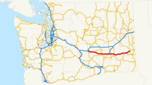
length_mi=133.61
length_round=2
length_ref=cite web |author=Washington State Department of Transportation |url=http://www.wsdot.wa.gov/mapsdata/tdo/PDF_and_ZIP_Files/HwyLog2006.pdf |title=State Highway Log, 2006 |accessdate=2008-09-24 |format=pdf]
established=1964cite web |url=http://apps.leg.wa.gov/RCW/default.aspx?cite=47.17.110 |title=RCW 47.17.110: State Route 26 |author=Washington State Legislature |accessdate=2008-09-25]
direction_a=West
terminus_a=jct|state=WA|I|90 near Vantage
junction=jct|state=WA|SR|24 in Othello
jct|state=WA|SR|17 in Othello
jct|state=WA|US|395 near Hatton
jct|state=WA|SR|261 in Washtucna
direction_b=East
terminus_b= jct|state=WA|US|195 in Colfax
previous_type=SR
previous_route=25
next_type=SR
next_route=27State Route 26 (SR 26) is a state highway in the Grant, Adams, and Whitman counties, in the U.S. state of
Washington . It extends convert|133.61|mi|km|2 from Interstate 90 (I-90) east of the community of Vantage, east toU.S. Route 195 (US 195) in Colfax. SR 26 intersects SR 24, SR 17, US 395, and SR 261 before ending in Colfax. The route serves as a connector between Vantage, Royal City, Othello, Washtucna, La Crosse, and Colfax.cite map |publisher=Google Maps |title=State Route 26 Overview Map |url=http://maps.google.com/maps?f=d&saddr=I-90+E&daddr=46.80758,-119.234619+to:WA-195&hl=en&geocode=FVLFzAId2nHZ-A%3B%3BFeyBywIdCi4B-Q&mra=dpe&mrcr=0&mrsp=1&sz=7&via=1&sll=47.040182,-119.498291&sspn=2.268431,4.570312&ie=UTF8&ll=46.83765,-118.99292&spn=2.277026,4.570312&z=7 |year=2008 |cartography=NATVEQ |accessdate=2008-09-25]SR 26 has its own
spur route located in Colfax. SR 26 from Vantage to Washtucna wasSecondary State Highway 7C (SSH 7C) from an unknown date until 1964, Washtucna to Dusty was SSH 11B, and from Dusty to US 195 in Colfax was US 295 from 1926 until 1967, when US 295 was removed from the system. That portion of SR 26 had also been part of State Road 3 from 1923 until 1937, when State Road 3 was replaced by Primary State Highway 3 (PSH 3). PSH 3 existed until 1964, when a highway renumbering occurred, which created SR 26.Route description
SR 26 runs convert|133.61|mi|km|2 from I-90 east of Vantage, east to US 195 in Colfax. The route links Vantage, Royal City, Othello, Washtucna, La Crosse, and Colfax, and intersects four highways: SR 24, SR 17, US 395, and SR 261 before ending at US 195. [cite map |publisher=
Rand McNally |title=The Road Atlas |year=2008 |page=109 |section=H13, H14, H15, H16, H17, H18, H19 |isbn=0528939610] cite map |publisher=G.M. Johnson |title=Inland Empire |url=http://store.maplink.com/map.aspx?nav=MS&cid=10056,10078&pid=522933 |edition=2007 edition |year=2007 |accessdate=2008-09-26] WSDOT has found that about 5,400 motorists utilize the road daily at the intersection with First Street in Othello based onaverage annual daily traffic (AADT) data.cite web |url=http://www.wsdot.wa.gov/mapsdata/tdo/PDF_and_ZIP_Files/Annual_Traffic_Report_2007.pdf |title=Washington Annual Average Daily Traffic Data |author=Washington State Department of Transportation |year=2007 |accessdate=2008-09-26]SR 26 starts at I-90 east of Vantage, about convert|0.36|mi|km east of the
Vantage Bridge , where I-90 travels over theColumbia River , and the highway starts at the opposite side of the river fromGinkgo/Wanapum State Park . [cite map |publisher=Google Maps |title=I-90 Map (Vantage to SR 26) |url=http://maps.google.com/maps?f=d&saddr=46.942235,-119.971561&daddr=I-90+E&hl=en&geocode=%3BFSZRzAIdYIPZ-A&mra=dme&mrcr=0&mrsp=0&sz=14&sll=46.942117,-119.974136&sspn=0.017756,0.035706&ie=UTF8&ll=46.942791,-119.968514&spn=0.008878,0.017853&z=15 |year=2008 |cartography=NATVEQ |accessdate=2008-09-27] [cite map |publisher=Washington State Department of Transportation |title=I-90 / SR 26 – Interchange Ramp Improvements Map |url=http://www.wsdot.wa.gov/Regions/NorthCentral/projects/I90SR26IC/Map.htm |year=2008 |cartography=Tele Atlas |accessdate=2008-10-03] From the interchange, SR 26 runs south to intersect SR 243 and then the highway turns east past Royal City and intersects SR 262 before entering theColumbia National Wildlife Refuge and leaving Grant County to enter Adams County. [cite map |publisher=Google Maps |title=SR 26 Map (I-90 to Grant/Adams County Line) |url=http://maps.google.com/maps?f=d&saddr=Rd+13%2FWA-26&daddr=46.816038,-119.358902&hl=en&geocode=FSxQzAId5IrZ-A%3B&mra=mi&mrsp=1,0&sz=12&sll=46.830134,-119.390831&sspn=0.071171,0.142822&ie=UTF8&ll=46.8846,-119.698792&spn=0.568784,1.142578&z=9 |year=2008 |cartography=NATVEQ |accessdate=2008-09-27] cite map |publisher=Washington State Department of Transportation |title=SR 26 – Intersection Illumination Map |url=http://www.wsdot.wa.gov/Projects/SR26/IntersectionIllumination/Map.htm |year=2008 |cartography=Tele Atlas |accessdate=2008-10-03] [cite map |publisher=Washington State Department of Transportation |title=SR 26 – Thacker Rd. West of Othello Project Map |url=http://www.wsdot.wa.gov/Projects/SR26/ThackerRoadTurnLanes/map.htm |year=2008 |cartography=Tele Atlas |accessdate=2008-10-03]After entering Adams County, SR 26 leaves the
Columbia National Wildlife Refuge and goes east to Othello and intersects SR 24 and SR 17. From Othello, the road continues east to Hatton and intersects US 395 and SR 21. From the intersections, the highway goes eastward to Washtucna, where it intersects SR 261 and dips to its southernmost point, about convert|4.3|mi|km east of Washtucna, and then passes Hooper. [cite map |publisher=Google Maps |title=SR 26 Map (SR 261 to Southernmost point) |url=http://maps.google.com/maps?f=d&saddr=Rd+13%2FWA-26&daddr=46.742213,-118.223705&hl=en&geocode=FQJ6yQIdzsHy-A%3B&mra=mi&mrsp=1,0&sz=13&sll=46.743272,-118.229542&sspn=0.035643,0.071411&ie=UTF8&ll=46.745507,-118.276062&spn=0.071283,0.142822&z=12 |year=2008 |cartography=NATVEQ |accessdate=2008-09-27] The road then exits Adams County and enters Whitman County. [cite map |publisher=Google Maps |title=SR 26 Map (Adams County) |url=http://maps.google.com/maps?f=d&saddr=Rd+13%2FWA-26&daddr=46.767147,-118.02887&hl=en&geocode=FQBaygIdRbni-A%3B&mra=mi&mrsp=1&sz=11&sll=46.810399,-118.017883&sspn=0.142394,0.285645&ie=UTF8&ll=46.811339,-118.778687&spn=1.139102,2.285156&z=8 |year=2008 |cartography=NATVEQ |accessdate=2008-09-27]After entering Whitman County, SR 26 goes northeast towards La Crosse and the
La Crosse Airport and then slightly turns east to Dusty. In Dusty, the road intersects the northern end of SR 127, former US 295 and then goes east and then northeast to Colfax and ends at US 195. [cite map |publisher=Google Maps |title=SR 26 Map (Adams/Whitman County Line to Colfax) |url=http://maps.google.com/maps?f=d&saddr=Rd+13%2FWA-26&daddr=46.891287,-117.36454&hl=en&geocode=FRGYyQIdRP_2-A%3B&mra=dme&mrcr=0&mrsp=1&sz=13&sll=46.892109,-117.3666&sspn=0.035545,0.071411&ie=UTF8&ll=46.809459,-117.704773&spn=0.56958,1.142578&z=9 |year=2008 |cartography=NATVEQ |accessdate=2008-09-27] cite map |publisher=Washington State Department of Transportation |title=SR 26 – Relief Bridge Scour Repair Map |url=http://www.wsdot.wa.gov/Projects/SR26/ReliefBridgeRepair/Map.htm |year=2008 |cartography=Tele Atlas |accessdate=2008-10-03]R 26 Spur
Shban
state = WA
route = 26
banner = SPUR
location = Colfax
active = 1970 – presentSR 26 Spur runs convert|0.07|mi|km|2 from SR 26 west of Colfax, east to US 195 in Colfax. The route goes from SR 26, then crosses the
Palouse River onto southbound US 195.cite map |publisher=Google Maps |title=State Route 26 Spur Overview Map |url=http://maps.google.com/maps?f=d&saddr=Rd+13%2FWA-26&daddr=46.88977,-117.364261&hl=en&geocode=FQZ-ywIdyCYB-Q%3B&mra=mi&mrsp=1,0&sz=17&sll=46.889909,-117.365195&sspn=0.002222,0.004463&ie=UTF8&ll=46.890144,-117.364824&spn=0.001111,0.002232&z=18 |year=2008 |cartography=NATVEQ |accessdate=2008-09-25] [cite map |publisher=Rand McNally |title=The Road Atlas |year=2008 |page=109 |section=H19 |isbn=0528939610] WSDOT has found that 3,200 motorists utilize the road daily.History
SR 26 became a state highway during the 1964 highway renumbering, in which the
Washington State Department of Transportation (WSDOT) replaced the previous system of Primary and Secondary Highways with a new system called State Routes, which is still in use today. Before the Primary and Secondary system, SR 26 in 1923 was part of State Road 3, which later became , to US 395, then known also as PSH 11, was added at an unknown time. Those highways became SR 26 in 1964, and US 295 was later removed from the system of highways in 1967.A couple of recent and current construction projects are occurring along SR 26. One of which, involves illuminating the highway's intersection with B SE, which was finished in 2008, and Reynolds Road, to be done in 2009, west and east of Othello, respectively. [cite web |url=http://www.wsdot.wa.gov/projects/sr26/intersectionillumination/ |title=SR 26 – Intersection Illumination Project |author=Washington State Department of Transportation |accessdate=2008-10-03] Another project added a left turn lane at a dangerous intersection between SR 26 and South Thacker Road west of Othello. [cite web |url=http://www.wsdot.wa.gov/projects/sr26/thackerroadturnlanes/ |title=SR 26 – Thacker Rd. West of Othello |author=Washington State Department of Transportation |accessdate=2008-10-03] The most major of the recent projects include the addition and demolition of ramps at the I-90 interchange. [cite web |url=http://www.wsdot.wa.gov/projects/i90/i90sr26ic/ |title=I-90 – SR 26 – Interchange – Ramp Improvements Project |author=Washington State Department of Transportation |accessdate=2008-10-03] Another minor project, a bridge fixing project, was completed in 2007, located northeast of Dusty and southwest of Colfax. [cite web |url=http://www.wsdot.wa.gov/projects/sr26/reliefbridgerepair/ |title=SR 26 – Relief Bridge Scour Repair |author=Washington State Department of Transportation |accessdate=2008-10-03]
Major intersections
References
External links
* [http://www.angelfire.com/wa2/hwysofwastate/sr026.html Highways of Washington State]

Wikimedia Foundation. 2010.