- Washington State Route 525
-
State Route 525
Whidbey Scenic Isle Way 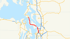
Route information Auxiliary route of I-5 Defined by RCW 47.17.735 Maintained by WSDOT Length: 30.67 mi[1] (49.36 km) Existed: 1964 – present Major junctions South end: 
 I-5/I-405 in Lynnwood
 SR 99 in Lynnwood

 SR 525 Spur in Mukilteo
 SR 526 in Mukilteo
North end:  SR 20 near Coupeville
Highway system State highways in Washington
Interstate • US • State
Former PSH • 1964 renumbering • Former SR←  SR 524
SR 526 →State Route 525, commonly abbreviated as SR 525, is a state highway in the U.S. state of Washington. It extends almost 31 miles (50 km) from Lynnwood in the south to an area near Keystone in the north, not counting a portion that is carried by the Washington State Ferries run from Mukilteo on the mainland to Clinton on Whidbey Island. While the route is signed North/South, nearly 10 miles (16 km) of the route runs mostly East/West, not counting the ferry portion, which runs in a Northwest/Southeast orientation.
On Whidbey Island, it is known as The Highway. In Lynnwood and Mukilteo it is known as Mukilteo Speedway.
Contents
Route description
SR 525 begins as a freeway, incorporating lanes extending from the northern terminus of Interstate 405 and ramps from its junction with Interstate 5 near Alderwood Mall in Lynnwood. From there it travels due north toward an overpass (built in 2000) over an interchange with State Route 99. From there, 525 becomes a boulevard, Mukilteo Speedway, and travels through the commercial and industrial areas of Mukilteo, passing the Southern end of Paine Field's runway 34L. In the North, the boulevard exits the right-of-way to create Paine Field Boulevard, signed as SR 525 Spur links SR 525 to SR 526, bypassing many signals and other roads while also shortening the route for people traveling to Everett and Boeing's Paine Field Plant..
As SR 525 heads Northward from the spur route's terminus, it shrinks to a two-lane city street until it reaches the western terminus of 526. There, a central left-turn lane is added. As 525 makes its way down the embankments of Mukilteo toward the ferry terminal. At Olympic View Middle School, turn lane ends and a ferry holding lane begins in the shoulder. (Travel in the holding lane is not permitted unless a backup has formed). At Goat Trail Road, the ferry holding lane becomes a lane for ferry traffic only. (All vehicles bound for the ferry must use the lane, and one may not enter the lane from that point on.) Traffic for Whidbey Island is funneled into a holding area, while local traffic may continue to the waterfront. (Both the holding area and the local street carry the designation of SR 525).
On the Whidbey Island side, 525 climbs a 9% grade, which sometimes causes new drivers of manual transmission vehicles to stall. The roadway is unbalanced, with two northbound lanes, a central turn lane, one southbound lane, and one ferry traffic holding lane (the same rules apply as in Mukilteo, and the compulsory entrance is at the intersection with Humphrey Rd.), the grade levels after a short distance to about 2% and the road travels through the community of Clinton. Just north of Clinton, the highway narrows again to two lanes and becomes a rural highway. It travels westward through the communities of Bayview and Freeland before turning north. It then passes through Greenbank and ends at its junction with State Route 20 near Keystone, just west of which is the ferry dock for Port Townsend on the Olympic Peninsula.
History


SR-525 was once two separate numbered highways prior to the 1964 Highway Renumbering. On Whidbey Island the route was known as SSH (Secondary State Highway) 1-D, and it extended north to Anacortes. On the mainland, the route was a portion of SSH 1-I along the Mukilteo Speedway to the ferry, SSH 1-I continued to Everett over Mukilteo Blvd./41st St. After the renumbering, the section of SSR 1I from Mukilteo to Everett became State Route 526. The entire route from SR-99 to Anacortes (at SR-536) lasted only a few years until the North Cascades Highway was completed in 1973, State Route 20 replaced SR 525 from Anacortes to Keystone and then was carried over the Keystone-Port Townsend ferry route to the Olympic Peninsula.
In the 1970s many sections of SR-525 were realigned or replaced to create a safer, more direct route on Whidbey Island. The former routing exists as local roads, and as a bike path parallel to some of the route. However, many sections of SR-525 (and other roads realigned during the same period) were completely closed and are now impassible.
Prior to the completion of Interstate 5 and Interstate 405 SSH-1I had its eastern terminus at U.S. Route 99 (aka PSH-1, now SR-99). After I-5 was completed, SR-525 was extended to the freeway via 35th Ave. W and 164th St. S, until 1985, when a freeway route from the terminus of I-405 to SR-99, paralleling 36th Ave. W and 35th Ave. W (which are physically the same road) was completed, however the entrance to this freeway was offset from the terminus of SR-525 by approximately 1/4 mile. The original proposal for the freeway had called for a direct connection over SR-99, however, the traffic volumes on the Mukilteo side of SR-99 were not high enough to warrant the construction. By the mid-90s however, traffic weaving between these segments of the route on SR-99 reached levels that prompted the WSDOT to reexamine the direct connection. In early 2000 the current overpass and interchange facility was constructed, this also gave impetus for an expansion of SR-525 from I-5 to SR-99, which had been a 2-lane, undivided freeway to a 4-lane, divided freeway, and for expansions from SR-99 to Paine Field Boulevard (SR-525 Spur), replacing the former two lane roadway with a 4 lane facility with travel directions separated by a barrier median.
Major intersections
County Location Mile[1] Destinations Notes Snohomish 0.00 I-405 south – Bellevue, RentonContinuation beyond I-5 0.00 I-5 south – SeattleNo connection between Southbound I-5 and Northbound 525 nor between Southbound 525 and Northbound I-5 0.62 Alderwood Mall Parkway Exit Only, utilizes additional lane that arrived at I-5 Interchange 2.74 SR 99 – Lynnwood, EverettUtilize surface streets for North 525 to South 99, South 99 to North 525, and South 525 to North 99 North end of freeway Mukilteo 5.77 To SR 526 (via SR 525 Spur) – Everett, Seattle6.68 SR 526 east to I-5 – Everett, Seattle8.64 Mukilteo-Clinton Ferry across Puget Sound Island 30.68 SR 20 – Coupeville, Anacortes Ferry, Port Townsend FerryRelated routes
Washington State Route 525 Spur

State Route 525 Spur
Location: near Paine Field Existed: 2001–present There is one bannered route of SR 525, called Washington State Route 525 Spur or SR 525 Spur, commissioned in 2001,[2] which connects with State Route 526 near Paine Field.
Paine Field Boulevard / SR 525 Spur begins at a Y-Intersection with SR 525 just outside of the residential areas of Mukilteo, Washington. It then travels north about 1.2 miles (2 km) to its terminus at SR 526. During its entire length, there are no intersections, save for the termini, and the speed limit is set at 45 miles per hour (72 km/h).
Paine Field Boulevard was created in 1999 to facilitate traffic flow to and from Boeing's Paine Field manufacturing facility by ensuring that it no longer interferes with ferry traffic on SR 525 bound for Whidbey Island. Also, many people working at Paine Field live in the Mukilteo neighborhood of Harbour Pointe, and this new route allows for more direct travel between work and home. Boeing also has an engineering facility in Harbour Pointe, so the logic of a more direct route for the engineers to travel to the plant becomes apparent.
State Route 525 Spur is 0.86 miles (1.38 km) long.[3]
Langley Loop
A new state, county, city partnership was created in 2009, to better direct traffic to the city of Langley, which resulted in the creation of the Langley Loop, a state sponsored, county and city maintained route. The route extends along Langley Rd. and Bayview Rd./Brooks Hill Rd. to Langley, then over various city streets. Signs have been produced, and will be installed in the fall of 2011.[4]
References
- ^ a b Washington State Department of Transportation, State Highway Log, 2006
- ^ RCW. "Revised Code of Washington regarding SR-525 (paragraph 2 is SR525 Spur)". http://apps.leg.wa.gov/RCW/default.aspx?cite=47.17.735. Retrieved 2008-06-16.
- ^ Washington State Department of Transportation. "State Highway Log, 2006" (PDF). http://www.wsdot.wa.gov/mapsdata/tdo/PDF_and_ZIP_Files/HwyLog2006.pdf. Retrieved 2007-04-22.
- ^ South Whidbey Record. "Langley hopes improved road markings will coax more people to town" (html). http://www.southwhidbeyrecord.com/news/119096509.html. Retrieved 2011-11-04.
External links
State highways in Washington related to I-5  SR 500 - SR 501 - SR 502 - SR 503 (Spur) - SR 504 (Spur) - SR 505 - SR 506 - SR 507 - SR 508 - SR 509 - SR 510 - SR 512 - SR 513 - SR 515 - SR 516 - SR 518 - SR 519 - SR 520 - SR 522 - SR 523 - SR 524 (Spur: Edmonds, Lynnwood) - SR 525 (Spur) - SR 526 - SR 527 - SR 528 - SR 529 (Spur) - SR 530 - SR 531 - SR 532 - SR 534 - SR 536 - SR 538 - SR 539 - SR 542 - SR 543 - SR 544 - SR 546 - SR 547 - SR 548 - SR 599Categories:
- State highways in Washington (state)
- Scenic highways in Washington (state)
- Transportation in Snohomish County, Washington
- Transportation in Island County, Washington


Wikimedia Foundation. 2010.