- Washington State Route 531
Infobox road
state=WA
type=SR
route=531
maint=WSDOT
section=757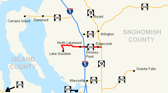
map_notes=SR 531 highlighted in red
length_mi=9.88
length_round=2
length_ref=cite web|author=Washington State Department of Transportation |url=http://www.wsdot.wa.gov/mapsdata/tdo/PDF_and_ZIP_Files/HwyLog2006.pdf|title=State Highway Log, 2006|accessdate=2007-04-22]
established=1991cite web |url=http://apps.leg.wa.gov/RCW/default.aspx?cite=47.26.167 |title=RCW 47.26.167 |accessmonthday=July 11 |accessyear=2008 |author=Washington State Legislature ]
direction_a=West
terminus_a=
junction=jct|state=WA|I|5 in North Lakewood
direction_b=East
terminus_b=jct|state=WA|SR|9 near Arlington
previous_type=SR
previous_route=530
next_type=SR
next_route=532
spur_of=5
spur_type=IState Route 531 (SR 531) is a short state highway in Snohomish County, in the U.S. state of
Washington . It extends convert|9.88|mi|km|2 fromWenberg State Park in the community of Lake Goodwin, east to SR 9 in southeast Arlington. SR 531 intersects Interstate 5 (I-5) and passes the Arlington Airport. The route serves as a connector from I-5 to SR 9, Smokey Point and Wenberg State Park.cite map |publisher=Google Maps |title=State Route 531 Overview Map |url=http://maps.google.com/maps?f=d&hl=en&geocode=14285895264413201861,48.136460,-122.281550&saddr=E+Lake+Goodwin+Rd+%4048.136460,+-122.281550&daddr=48.151636,-122.113273&mra=mi&mrsp=1,0&sz=17&doflg=ptm&sll=48.151357,-122.113026&sspn=0.00204,0.004206&ie=UTF8&ll=48.156467,-122.211227&spn=0.130547,0.269165&z=11 |year=2008 |cartography=Tele Atlas |accessdate=2008-07-23]SR 531 was approved by the
Washington State Legislature in 1991 along its current route. Since then, construction projects arranged by theWashington State Department of Transportation (WSDOT) have turned this small road into an arterial street.cite web |url=http://apps.leg.wa.gov/RCW/default.aspx?cite=47.17.757 |title=RCW 47.17.757 |accessdate = 2008-05-09| |author=Washington State Legislature] Even though SR 531 was approved by the Washington State Legislature and WSDOT in 1991, no signs went up until the law that made SR 531 took effect on April 1, 1992.Route description
State Route 531 runs about convert|9.88|mi|km|2 from
Wenberg State Park to State Route 9, south of Arlington. The route links the communities of Lake Goodwin, North Lakewood, also known as Lakewood, Smokey Point, and Edgecomb, and passes four schools in the Lakewood School District and one,Weston High School , in theArlington School District . The road intersects four major arteries: Forty-Five Road, Interstate 5,Smokey Point Boulevard (formerly known asU.S. Route 99 ), and 67th Avenue before ending at SR 9. [cite map |publisher=Rand McNally |title=The Road Atlas |year=2008 |page=108 |section=D7 |isbn=0528939610] WSDOT has found that about 35,000 motorists utilize the road daily at the I-5 interchange based onaverage annual daily traffic (AADT) data.cite web |url=http://www.wsdot.wa.gov/mapsdata/tdo/PDF_and_ZIP_Files/Annual_Traffic_Report_2007.pdf |title=Washington Annual Average Daily Traffic Data |author=Washington State Department of Transportation |year=2007 |accessdate=2008-08-26]Lake Goodwin to Smokey Point
Starting at Wenberg State Park, the route runs north along East Lake Goodwin Road until it intersects Lakewood Road. From there, SR 531 travels east along Lakewood Road around Lake Ki before reaching Forty-Five Road. Here, Lakewood Road becomes the main artery of North Lakewood and Smokey Point, 172nd Street. Continuing east, SR 531 intersects 11th Avenue. [cite map |publisher=Google Maps |title=State Route 531 Map (Wenberg SP to Lakewood Rd.) |url=http://maps.google.com/maps?f=d&hl=en&geocode=7245095047774436496,48.136422,-122.281552&saddr=E+Lake+Goodwin+Rd+%4048.136422,+-122.281552&daddr=48.155737,-122.289205&mra=mi&mrsp=1,0&sz=16&doflg=ptm&sll=48.155279,-122.289891&sspn=0.00408,0.008411&ie=UTF8&ll=48.14845,-122.29414&spn=0.032642,0.067291&z=13 |year=2008 |cartography=Tele Atlas |accessdate=2008-07-23]
At the intersection with 11th Avenue, SR 531 becomes the northern boundary of the Lakewood High School campus, the only high school in the Lakewood area. SR 531 continues east from 11th Avenue to 16th Drive. Soon thereafter, the road intersects 19th Drive, which connects the southeastern section of North Lakewood with SR 531. Continuing east across a
double track , the highway intersects 27th Avenue, which connects the road withLakewood Crossing , a shopping center in Lakewood. SR 531 then continues east to the interchange with I-5. [cite map |publisher=Google Maps |title=State Route 531 Map (Lakewood Rd. to Forty-Five Road) |url=http://maps.google.com/maps?f=d&hl=en&geocode=9337960409365308793,48.155720,-122.289170&saddr=E+Lake+Goodwin+Rd+%4048.155720,+-122.289170&daddr=48.152087,-122.238221&mra=mi&mrsp=1&sz=15&doflg=ptm&sll=48.152717,-122.240796&sspn=0.00816,0.016823&ie=UTF8&ll=48.156582,-122.265987&spn=0.032637,0.067291&z=13 |year=2008 |cartography=Tele Atlas |accessdate=2008-07-23] [cite map |publisher=Google Maps |title=State Route 531 Map (Forty-Five Road to I-5) |url=http://maps.google.com/maps?f=d&hl=en&geocode=699507238980297552,48.151970,-122.238350&saddr=Lakewood+Rd%2FWA-531+%4048.151970,+-122.238350&daddr=48.152359,-122.188826&mra=mi&mrsp=1&sz=16&doflg=ptm&sll=48.152931,-122.191014&sspn=0.00408,0.008411&ie=UTF8&ll=48.153719,-122.214146&spn=0.032639,0.067291&z=13 |year=2008 |cartography=Tele Atlas |accessdate=2008-07-23]mokey Point to Edgecomb
After leaving the interchange with I-5 and North Lakewood, SR 531 goes east to Smokey Point Boulevard (formerly U.S. Route 99) in Smokey Point. The road then continues going east, passing Weston High School and Arlington Municipal Airport, before intersecting 67th Avenue, a major road from Marysville to Arlington. From 67th Avenue, SR 531 goes east to a suburban community known as Edgecomb. The road curves northeast and then southeast while on a hill. SR 531 then goes east past the Arlington Gun Range and Gleneagle (a large housing area) before ending at an intersection with SR 9. [cite map |publisher=Google Maps |title=State Route 531 Map (I-5 to 67th Ave.) |url=http://maps.google.com/maps?f=d&hl=en&geocode=17034476285249654328,48.152315,-122.188823&saddr=172nd+St+NE%2FWA-531+%4048.152315,+-122.188823&daddr=48.151972,-122.140546&mra=mi&mrsp=1&sz=15&doflg=ptm&sll=48.152917,-122.145739&sspn=0.00816,0.016823&ie=UTF8&ll=48.153948,-122.165051&spn=0.032638,0.067291&z=13 |year=2008 |cartography=Tele Atlas |accessdate=2008-07-23] [cite map |publisher=Google Maps |title=State Route 531 Map (67th Ave. to SR 9) |url=http://maps.google.com/maps?f=d&hl=en&geocode=12035328852847921867,48.151640,-122.113295%3B2611271918793144656,48.151940,-122.140560&saddr=172nd+St+NE%2FWA-531+%4048.151940,+-122.140560&daddr=172nd+St+NE%2FWA-531+%4048.151640,+-122.113295&mra=ps&mrcr=0&doflg=ptm&sll=48.153261,-122.128572&sspn=0.016319,0.033646&ie=UTF8&z=14 |year=2008 |cartography=NTele Atlas |accessdate=2008-07-23] [cite map |title=Official State Highway Map |url=http://www.wsdot.wa.gov/NR/rdonlyres/87105CAD-83A9-49A7-80F3-5719637C1E2D/0/FrontMapBig.pdf |publisher=Washington State Department of Transportation |location=Olympia, Washington |year=2008 |edition=2008-2009 |scale=1:842,000 |series=Official State Highway Maps |cartography=
U.S. Geological Survey |section=3C |accessdate=2008-07-23] cite map |author=GM Johnson |title=Marysville, Arington, Stanwood, Camano Island |url=http://store.maplink.com/map.aspx?nav=MS&cid=10056,10078&pid=522941 |publisher=GM Johnson |location=Burnaby, British Columbia |year=2004 |edition=2004 |series=City Street Maps |isbn=1897152671 |accessdate=2008-07-07]Extensions and names
An extension called 172nd Street NE continues east for convert|0.2|mi|km [cite map |publisher=Google Maps |title=Length of 172nd Street NE |url=http://maps.google.com/maps?f=d&hl=en&geocode=5056291610718799248,48.151640,-122.113220&saddr=WA-9+%4048.151640,+-122.113220&daddr=48.151714,-122.108831&mra=mi&mrsp=1,0&sz=14&doflg=ptm&sll=48.150541,-122.116942&sspn=0.01632,0.033646&ie=UTF8&z=14 |year=2008 |cartography=Tele Atlas |accessdate=2008-07-23] from the SR 531/SR 9 intersection to 91st Street. This section is not part of the route but connects it to small housing areas. [cite map |publisher=Google Maps |title=172nd Street NE Map |url=http://maps.google.com/?ie=UTF8&ll=48.151521,-122.11072&spn=0.001883,0.008368&z=17 |year=2008 |cartography=Tele Atlas |accessdate=2008-07-23] Lakewood Road continues west for convert|3.5|mi|km [cite map |publisher=Google Maps |title=Length of Lakewood Road |url=http://maps.google.com/maps?f=d&hl=en&geocode=9337960409365308793,48.155720,-122.289170&saddr=48.167001,-122.357826&daddr=E+Lake+Goodwin+Rd+%4048.155720,+-122.289170&mra=mi&mrsp=0,1&sz=12&doflg=ptm&sll=48.17387,-122.338257&sspn=0.065251,0.134583&ie=UTF8&z=12 |year=2008 |cartography=Tele Atlas |accessdate=2008-07-23] from the SR 531/East Lake Goodwin Road intersection. It then intersects West Lake Goodwin Road before ending at Marine Drive in Warm Beach. [cite map |publisher=Google Maps |title=Lakewood Road Map |url=http://maps.google.com/?ie=UTF8&ll=48.160704,-122.324266&spn=0.016317,0.066948&z=14 |year=2008 |cartography=Tele Atlas |accessdate=2008-07-23]
East Lake Goodwin Road continues south for convert|1.1|mi|km [cite map |publisher=Google Maps |title=Length of East Lake Goodwin Road |url=http://maps.google.com/maps?f=d&hl=en&geocode=5087439848613291345,48.136420,-122.281552&saddr=E+Lake+Goodwin+Rd+%4048.136420,+-122.281552&daddr=48.127257,-122.296457&mra=mi&mrsp=1,0&sz=14&doflg=ptm&sll=48.131898,-122.28796&sspn=0.016326,0.033646&ie=UTF8&z=14 |year=2008 |cartography=Tele Atlas |accessdate=2008-07-23] from Wenberg State Park, the western end of State Route 531, to West Lake Goodwin Road on the south shore of Lake Goodwin, where the road ends. [cite map |publisher=Google Maps |title=East Lake Goodwin Road Map |url=http://maps.google.com/?ie=UTF8&ll=48.131497,-122.282896&spn=0.016326,0.066948&z=14 |year=2008 |cartography=Tele Atlas |accessdate=2008-07-23] SR 531 has various names along the route. The first road is East Lake Goodwin Road, which is part of SR 531 from the western end at Wenberg State Park to an intersection with Lakewood Road. The second road is Lakewood Road, which is part of the highway from the intersection with East Lake Goodwin Road to the intersection with Forty-Five Road. The third and final road is 172nd Street, which is part of SR 531 from the intersection with Forty-Five Road to the east end of SR 531 at an intersection with SR l9.
History
The whole route of the highway from East Lake Goodwin Road to current SR 9 has been known to exist earlier than 1911.cite map |publisher=
United States Geological Survey |title=Topography map of Mount Vernon and Vincity |url=http://content.wsulibs.wsu.edu/cgi-bin/pview.exe?CISOROOT=/maps&CISOPTR=447&CISORESTMP=/qbuild/buildplate11.html&CISOVIEWTMP=/qbuild/buildplate12.html&CISOROWS=2&CISOCOLS=5&CISOCLICK=title:subjec:creato:date:type |edition=January 1911 |year=1911 |scale=1:125,000 |accessdate=2008-09-12] The route from East Lake Goodwin Road south toWenberg State Park was not opened until after the park opened. Also, 172nd Street NE once extended from current SR 9 to the banks of the South Fork Stillaguamish River, which has since been removed.SR 531 became a state highway in 1991, and the highway designation took effect on April 1, 1992. In 2006, WSDOT announced it would complete three more projects over about five years to improve SR 531. The first, to improve the bridge and interchange between I-5 and SR 531, began immediately. [cite web |url=http://www.wsdot.wa.gov/Projects/SR531/SmokeyPt/ |title=I-5/SR 531 Interchange Improvements |accessdate=2008-05-10 |author=Washington State Department of Transportation] It was partly finished in June 2006 and will be completed after a
loop ramp is added in 2011. In August 2007, WSDOT completed a project to add sidewalks along SR 531 to the adjacent schools of the Lakewood School District. [cite web |url=http://www.wsdot.wa.gov/Projects/SR531/LakewoodSchoolsSidewalks/ |title=SR 531 Lakewood Schools Sidewalks | accessdate=2008-05-10 |author=Washington State Department of Transportation] The third project, adding the loop ramp, will start in 2009 and end in 2011. [cite web |url=http://www.wsdot.wa.gov/Projects/SR531/I5LoopRamp/ |title=I-5/SR 531 Loop Ramp |accessdate=2008-05-10 |author=Washington State Department of Transportation] A separate construction project is to widen SR 531 between 43rd Avenue NE and 67th Avenue NE from its current two to five lanes near the Arlington Airport. [cite web |url=http://search.wsdot.wa.gov/search?q=cache:xg_rZ632b4wJ:www.wsdot.wa.gov/NR/rdonlyres/9CA40350-0697-4D34-AD45-154CC268A645/0/ExhibitCWebsite.pdf+67th+Avenue+NE&access=p&output=xml_no_dtd&site=AllSites&ie=UTF-8&client=www&proxystylesheet=www&oe=ISO-8859-1 |title=SR 531 Widening Project- 43rd Avenue to 67th Avenue |author=Washington State Department of Transportation |accessdate=2008-07-07] [cite news |title=RTID transportation, transit improvement goes to Marysville voters Nov. 6 |author=City of Marysville |url=http://ci.marysville.wa.us/DownloadFTP/newsletters/fall2007mm.pdf |format=PDF |work=Marysville Messenger |publisher=City of Marysville |location=Marysville |page=6 |date=Fall 2007 |accessdate=2008-07-15 ]Major intersections
References
External links
* [http://www.wsdot.wa.gov/projects/sr531/smokeypt Washington State Department of Transportation: 2006 overpass widening]
* [http://www.wsdot.wa.gov/Projects/SR531/I5LoopRamp/ Washington State Department of Transportation: 2009 overpass work]
* [http://www.wsdot.wa.gov/Traffic/seattle/sr531.htm#cam Traffic camera for SR 531 – I-5 interchange (WSDOT)]
Wikimedia Foundation. 2010.