- New York State Route 531
-
NYS Route 531
Spencerport Expressway 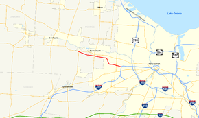
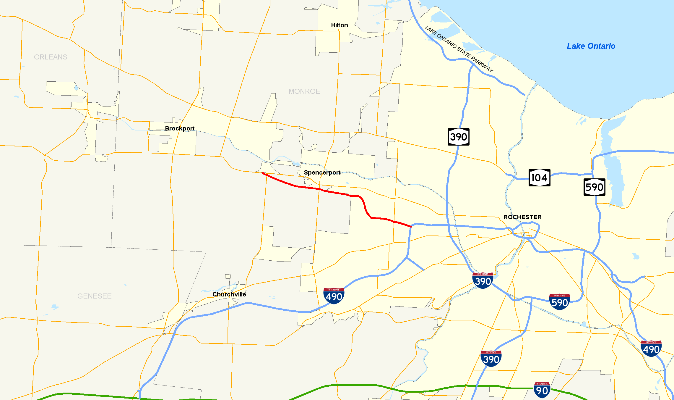
Map of the Rochester area with NY 531 highlighted in redRoute information Maintained by NYSDOT Length: 8.02 mi[2] (12.91 km) Existed: 1984[1] – present Major junctions West end: 
 NY 31 / NY 36 in Ogden
East end:  I-490 in Gates
Location Counties: Monroe Highway system Numbered highways in New York
Interstate • U.S. • N.Y. (former) • Reference • County←  NY 495
I-587  →
→New York State Route 531 (NY 531) is a limited-access, east–west state highway located in Monroe County, New York, in the United States. The route extends for 8.02 miles (12.91 km) from the far northwestern suburbs of Rochester to the town of Gates located just west of the city. The western terminus of the route is at an intersection with NY 31 and NY 36 west of the village of Spencerport in the town of Ogden, while the eastern terminus of NY 531 is at Interstate 490 (I-490) exit 8 2 miles (3.2 km) west of the Rochester city limits. NY 531 is the primary route between Rochester and the village of Brockport, located 5 miles (8 km) northwest of NY 531's west end.
The expressway was constructed in three sections, the first of which opened in the 1960s as New York State Route 940P, an unsigned reference route, and extended from I-490 to Elmgrove Road. An extension of NY 940P to Manitou Road was completed in 1984, at which time the expressway was redesignated as NY 531. The final section between NY 36 and Manitou Road opened to traffic in 1995. NY 531 is officially designated the Senator Ralph Quattrociocchi Memorial Highway in honor of Ralph E. Quattrociocchi, a New York State Senator who played a large role in making the second extension of NY 531 possible. The road is also known as the Spencerport Expressway, named for the village near the highway's western terminus.
In the mid-2000s, a number of grants were given by various agencies to the New York State Department of Transportation (NYSDOT) to finance research and planning for a potential extension of NY 531 westward to Redman Road in Brockport. A 2007 meeting between residents of Brockport and officials from NYSDOT revealed three options that were under consideration: an extension of NY 531 to Redman Road, the widening of NY 31 through the towns of Ogden and Sweden, and keeping the status quo. Ultimately, the first two options were ruled out in 2009, at which time NYSDOT announced only small-scale projects to alleviate areas of traffic congestion will be considered.
Contents
Route description
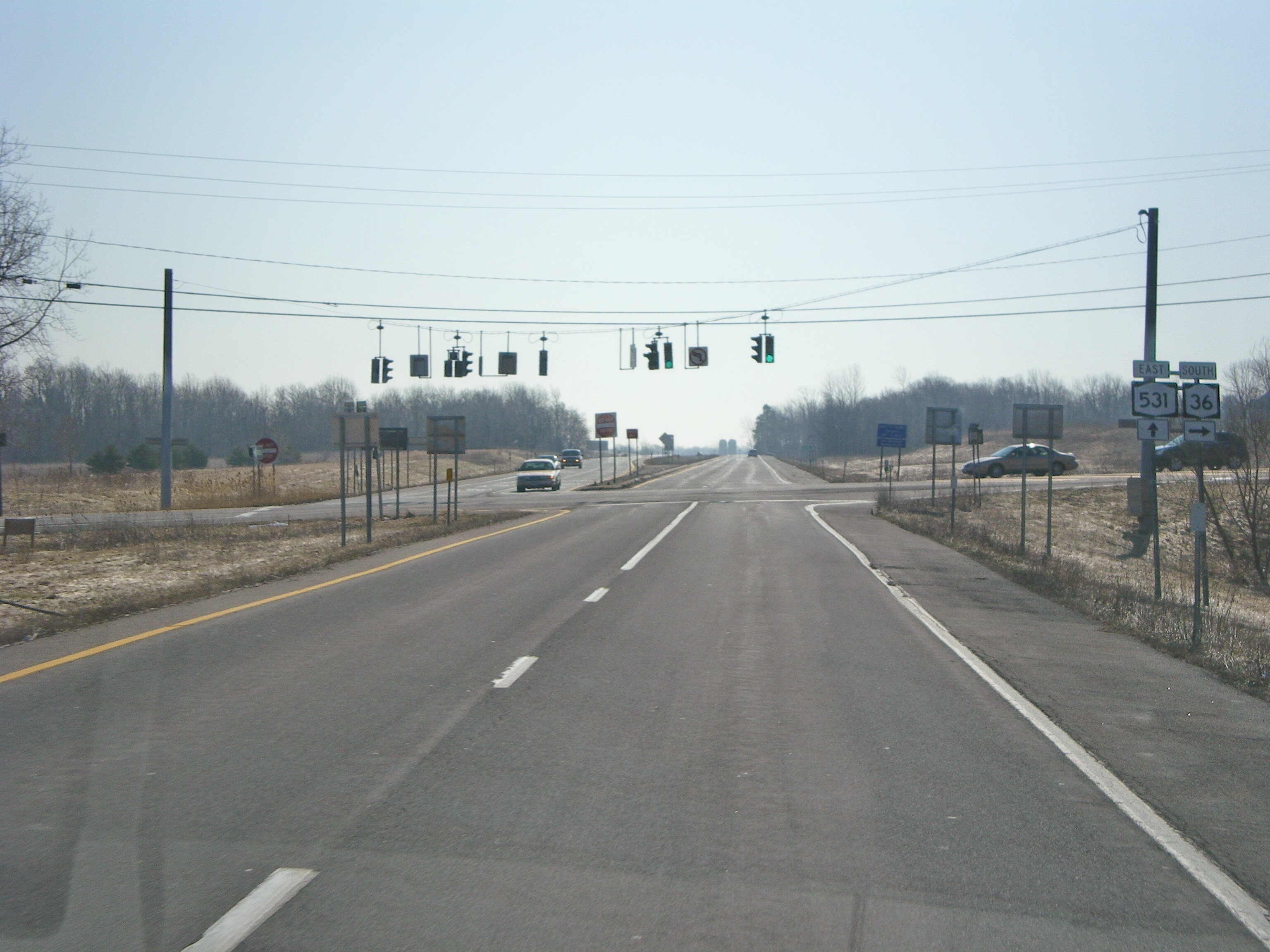
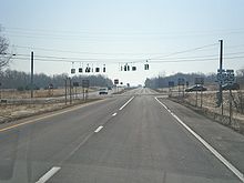 NY 531's western terminus at NY 36
Eastbound NY 531 begins at NY 31 a half-mile (0.8 km) west of the northern terminus of NY 36. NY 531 heads southeast from Brockport–Spencerport Road (NY 31), following a one-lane ramp east to NY 36. Shortly before intersecting with Washington Street (NY 36) at an at-grade intersection, the ramp widens to two lanes. At NY 36, NY 531 westbound terminates, forcing commuters to exit onto NY 36. Past the junction with NY 36, NY 531 becomes a four-lane limited-access highway, passing through open fields as it heads east through rural Ogden.[3]
Directly south of Spencerport, NY 531 encounters South Union Street (NY 259) by way of a diamond interchange bordered on both sides by small housing tracts. The roadway continues eastward, reentering open and mostly undeveloped areas of the town. It heads past farmland for 2 miles (3.2 km) before turning southward a short distance east of an overpass carrying Gillett Road. NY 531 proceeds due south for 0.75 miles (1.21 km), passing over Lyell Road at the midpoint of the segment, before returning to an east–west alignment just ahead of the Manitou Road exit, where NY 531 crosses into the town of Gates.[3]
Between Manitou Road and Elmgrove Road (NY 386), NY 531 is flanked on both sides by frontage roads 1.08-mile (1.74 km) in length. NY 531 eastbound connects to Manitou Road, NY 386, and the Rochester Tech Park solely by way of the south frontage road, designated NY 946E, while the north frontage road, designated NY 946F, acts as a collection road for the separate ramps to NY 386 and Manitou Road from NY 531 westbound. Both frontage road designations are unsigned reference routes;[2][3] in fact, reference markers along the two roads display "531" for the route number instead of their respective designations.[4] The westbound exit to the Rochester Tech Park, a standalone two-lane ramp that splits from NY 531 a short distance west of the NY 386 overpass, has no connection to the north frontage road.[3]
West of NY 386, the expressway expands to three lanes eastbound as it leaves the heavily commercialized and industrialized area around Elmgrove and Manitou Roads and enters a narrow, wooded area bordered by homes to the north. Not far to the east, NY 531 comes to an end at a slightly modified directional T interchange with I-490. Heading eastbound, the two leftmost lanes connect NY 531 to I-490 eastbound while the right lane links to I-490 westbound 0.25 miles (0.40 km) north of I-490's modified cloverleaf interchange with NY 33.[3]
History
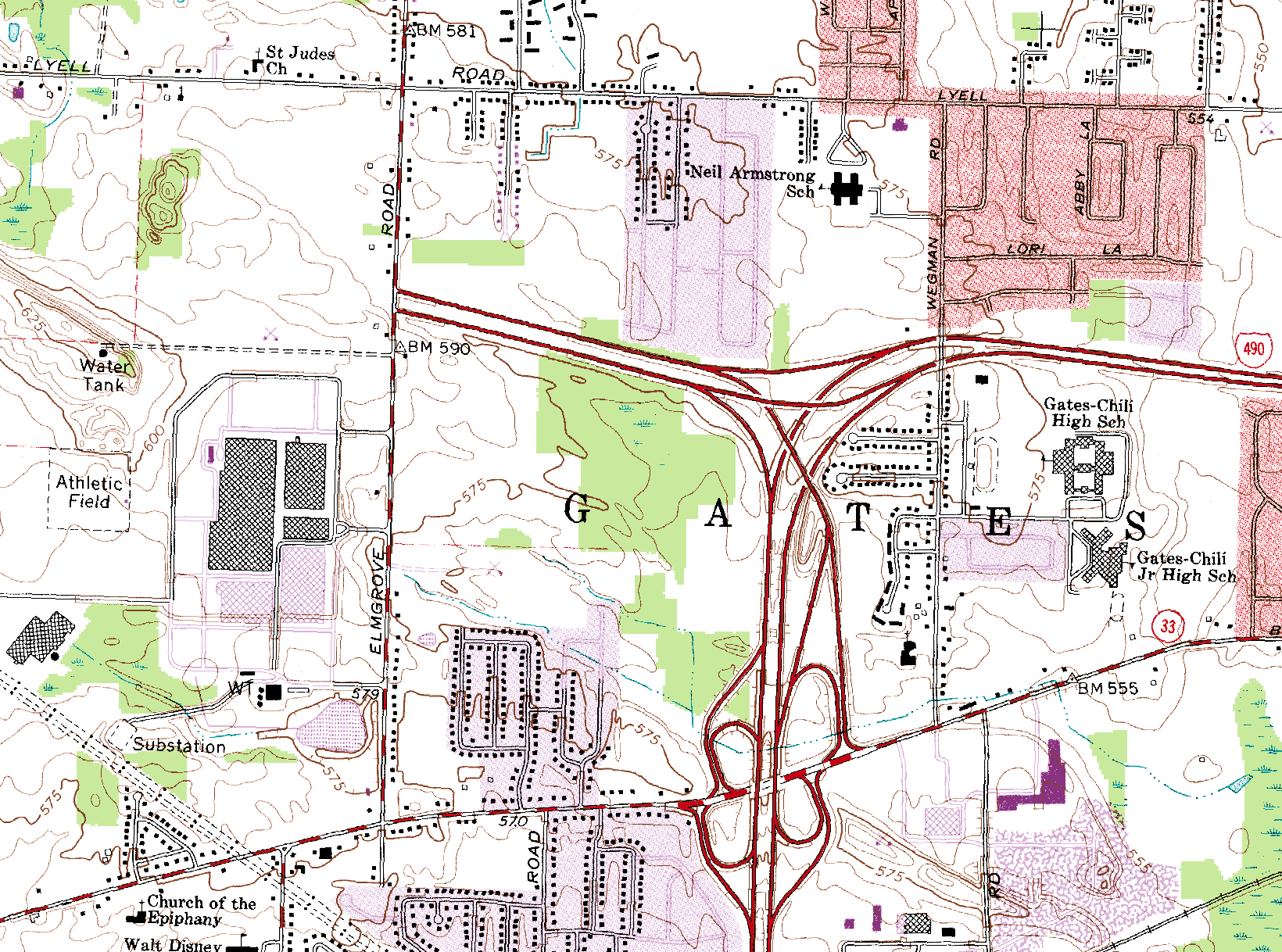
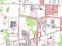 1978 United States Geological Survey topographic map of Gates, showing the entirety of then-NY 940P from Elmgrove Road to I-490
The Spencerport Expressway was conceived as part of a plan to link Rochester and Buffalo with a limited-access, toll-free highway. Although this plan was ultimately scrapped,[1] the first segment of the expressway from I-490 west to Elmgrove Road in Gates was built in the early 1960s and completed by 1964.[5][6] When it opened, it was designated as NY 940P, an unsigned reference route designation. In 1984, the expressway was extended westward to Manitou Road and was redesignated as the signed NY 531.[1]
In April 1987, plans to extend the expressway further westward to NY 36 in Ogden were set in motion. At that time, New York State Senator Ralph E. Quattrociocchi and State Assemblyman Steve Hawley introduced legislation requesting $15 million (equivalent to $29 million in 2011) for the extension of NY 531 west to Washington Street (NY 36). The money would be appropriated to NYSDOT.[7][8] More money was devoted to the project as part of a $3 billion (equivalent to $5.57 billion in 2011) bond issue dubbed "Rebuild New York" that was presented to voters during the November 1988 elections.[9][8] The measure was approved with 55% of the vote.[10] The money assigned to NY 531 went toward 2.3 miles (3.7 km) of the route's extension.[9]
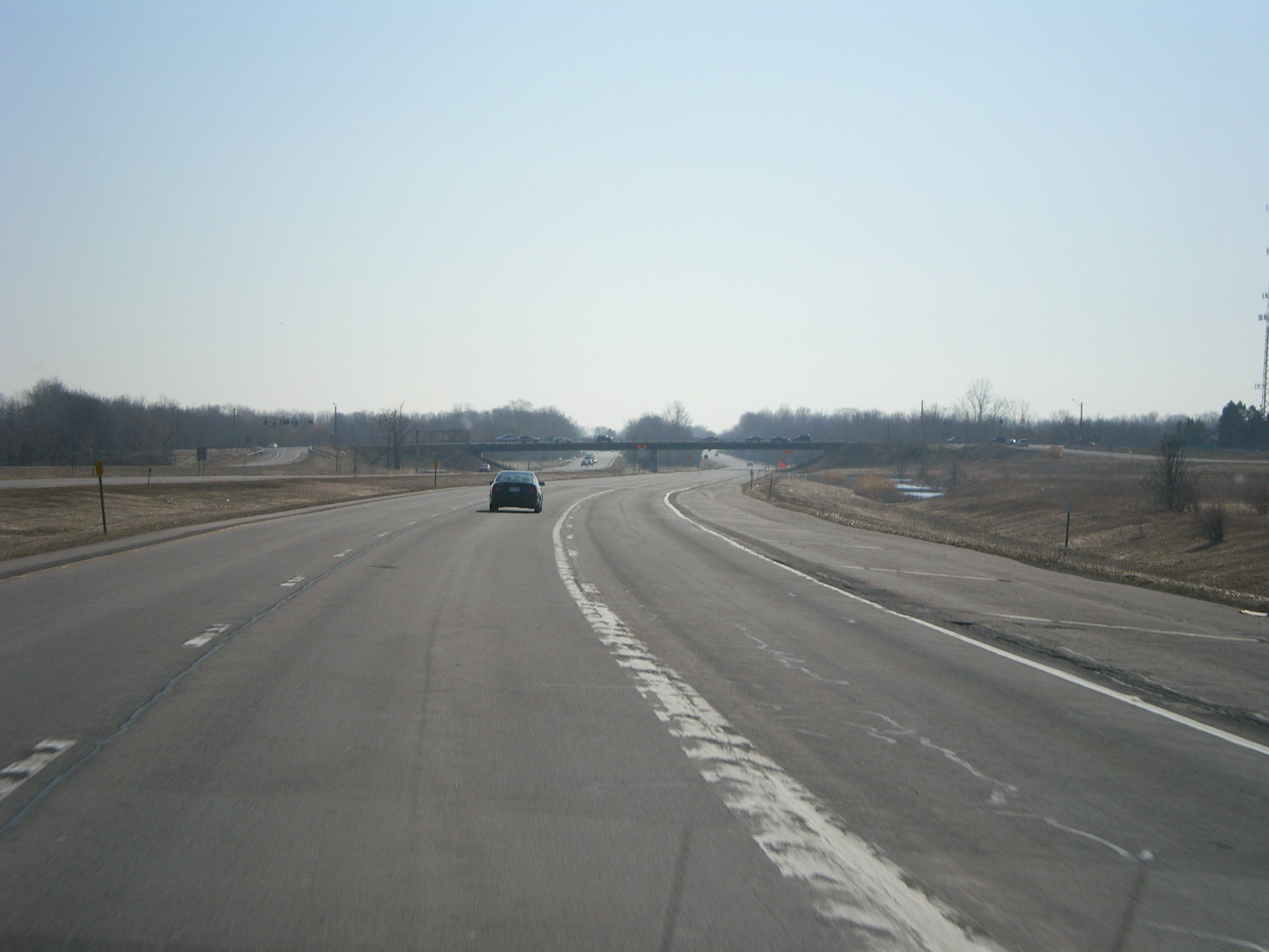
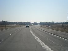 NY 531's interchange with NY 386. Until 1984, this interchange was the expressway's western terminus.
Despite the presence of funding, construction was delayed on the extension until 1993 due to opposition from residents of the communities surrounding NY 531's future routing—namely Gates, Spencerport and Ogden. The new segment of NY 531 opened to traffic in 1995.[1] The entirety of NY 531 is dedicated the "Senator Ralph Quattrociocchi Memorial Highway" by NYSDOT in honor of Quattrociocchi and his role in making the second extension possible.[11]
Proposed extension and improvements
In July 2004, the Genesee Transportation Council added $5.8 million to its Transportation Improvement Program aimed at stimulating the effort to extend NY 531 westward toward Brockport. The money went to NYSDOT for engineering and environmental studies,[12] which began that year.[13] Later, in September 2005, another $5.92 million was secured by Monroe County through efforts coordinated by then-United States Representative Tom Reynolds. The amount was put toward the completion of the planning phase of the project.[14]
On January 10, 2007, NYSDOT held a meeting in Brockport to discuss the future of NY 531. Three options were considered at the event. The first option advocated status quo, keeping the western terminus of NY 531 at NY 36. The second, most expensive option, would result in the extension of NY 531 along a new right-of-way to Redman Road, 1 mile (1.6 km) west of NY 19, southwest of Brockport at a cost of $94 million. The third option would be to upgrade NY 31 between NY 36 and Redman Road at an expense of $41 million. The second option, if chosen, would have been difficult to implement due to its cost. As the annual budget of all of NYSDOT Region 4 equates to $90 million, the project would have to be constructed as financing became available. Two more meetings were planned in 2008 and 2009, and a request for approval of the completed design was scheduled for late 2009.[15]
On March 26, 2009, NYSDOT announced that they were no longer considering extending NY 531 to Redman Road. The state cited the project's price tag,[16] which had risen to $125 million,[13] and the existing road infrastructure in the area,[16] which the state deemed satisfactory and as not in need of an extension of NY 531.[13] Also ruled out by the DOT was the widening of NY 31 through Ogden and Sweden.[17] Instead, NYSDOT will shift its focus to alleviating traffic issues at the junction of NY 531 and NY 36.[16] Improvements considered by NYSDOT include constructing bridges for NY 531 over NY 31 and/or NY 36, converting the at-grade intersection between NY 36 and NY 531 into a diamond interchange, or some combination of those and other, unnamed options. These smaller-scale projects, termed "spot improvements" by the DOT, range in cost from $12 million to $20 million.[13]
Exit list
The entire route is in Monroe County. All exits are unnumbered.
Location Mile[2] Exit Destinations Notes Ogden 0.00 NY 36At-grade intersection; access to NY 31 via NY 36 north 2.61  NY 259 (Union Street) – Spencerport
Gates 5.89 Manitou Road 6.37 Rochester Tech Park 6.99  NY 386 (Elmgrove Road)
8.02 I-490 – Rochester, BuffaloEastbound exit and westbound entrance 1.000 mi = 1.609 km; 1.000 km = 0.621 mi References
- ^ a b c d Sinsabaugh, Mark. "New York State Route 531". New York Routes. http://www.gribblenation.net/nyroutes/ind/500_599.htm#531. Retrieved March 30, 2009.
- ^ a b c "2008 Traffic Volume Report for New York State" (PDF). New York State Department of Transportation. June 16, 2009. pp. 241, 273. https://www.nysdot.gov/divisions/engineering/technical-services/hds-respository/NYSDOT%20TVR%202008%20by%20Route.pdf. Retrieved February 1, 2010.
- ^ a b c d e Yahoo! Inc. Yahoo! Maps – overview map of NY 531 (Map). Cartography by NAVTEQ. http://maps.yahoo.com/#mvt=h&lat=43.172195&lon=-77.78666&zoom=14&q1=43.188393%2C-77.862709&q2=43.157447%2C-77.710639. Retrieved November 13, 2010.
- ^ Perry, N.W.. "Reference Routes, Region 4". Empire State Roads. http://www.empirestateroads.com/sr/refroute4.html. Retrieved February 11, 2007.
- ^ Sinclair Oil Corporation (1962). New York and Metropolitan New York (Map). Cartography by Rand McNally and Company.
- ^ Sinclair Oil Corporation (1964). New York and Metropolitan New York (Map). Cartography by Rand McNally and Company.
- ^ "Yesterday's News for April 2002". Westside News (Spencerport, New York). April 2002. http://www.westsidenewsonline.com/YesterdayNews/YN042002.html. Retrieved March 30, 2009.
- ^ a b Consumer Price Index (estimate) 1800–2008. Federal Reserve Bank of Minneapolis. Retrieved December 7, 2010.
- ^ a b Kolbert, Elizabeth (October 14, 1988). "Bond Issue For Roads Gets Push". The New York Times. http://www.nytimes.com/1988/10/14/nyregion/bond-issue-for-roads-gets-push.html. Retrieved March 30, 2009.
- ^ Kennedy, Randy (November 6, 2000). "$3.8 Billion Transportation Bond Act Flying Below New York Voters' Radar". The New York Times. http://www.nytimes.com/2000/11/06/nyregion/3.8-billion-transportation-bond-act-flying-below-new-york-voters-radar.html. Retrieved March 30, 2009.
- ^ New York State Department of Transportation (January 2009) (PDF). Official Description of Highway Touring Routes, Bicycling Touring Routes, Scenic Byways, & Commemorative/Memorial Designations in New York State. https://www.nysdot.gov/divisions/operating/oom/transportation-systems/repository/2009%20tour-bk.pdf. Retrieved March 30, 2009.
- ^ "Route 531 Extension Plan Moves Ahead". Westside News (Spencerport, New York). July 11, 2004. http://westsidenewsonline.com/OldSite/westside/news/2004/0711/features/route531.html. Retrieved March 30, 2009.
- ^ a b c d Morrell, Alan (March 30, 2009). "Route 531 won't get expansion". Democrat and Chronicle (Rochester, New York): p. 3B. http://www.democratandchronicle.com/apps/pbcs.dll/article?AID=2009903300328. Retrieved March 30, 2009.
- ^ "Route 531 Extension Project Receives More Funds". Westside News (Spencerport, New York). September 11, 2005. http://westsidenewsonline.com/OldSite/westside/news/2005/0911/features/route531.html. Retrieved March 30, 2009.
- ^ "Residents and officials discuss Route 531 extension options". Westside News (Spencerport, New York). January 14, 2007. http://westsidenewsonline.com/OldSite/westside/news/2007/0114/features/residents.html. Retrieved January 14, 2007.
- ^ a b c "Route 531 Extension Project Halted; DOT to Hold Meeting". 13WHAM News (Rochester, New York). March 26, 2009. http://www.13wham.com/news/local/story/Route-531-Extension-Project-Halted-DOT-to-Hold/i2CdJfUwgU28tt7l1UAkRQ.cspx. Retrieved March 30, 2009.
- ^ Lowell, Bud (March 26, 2009). "DOT Drops Expressway Plan". WXXI-TV (Rochester, New York). http://www.publicbroadcasting.net/wxxi/news.newsmain?action=article&ARTICLE_ID=1485875§ionID=1. Retrieved March 30, 2009.
External links
Categories:- State highways in New York
- Limited-access roads in New York
- Transportation in Monroe County, New York

Wikimedia Foundation. 2010.