- Monroe County, New York
-
Monroe County, New York 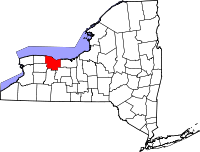
Location in the state of New York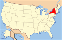
New York's location in the U.S.Founded 1821 Named for James Monroe Seat Rochester Area
- Total
- Land
- Water
1,366 sq mi (3,538 km²)
659 sq mi (1,707 km²)
706 sq mi (1,829 km²), 51.72%Population
- (2010)
- Density
744,344
1,129/sq mi (436/km²)Website www.monroecounty.gov/ Monroe County is a county located in the U.S. state of New York. As of the 2010 census, the population was 744,344. It is named after James Monroe, fifth President of the United States of America. Its county seat is the city of Rochester.
Monroe County is part of the Rochester, NY Metropolitan Statistical Area. It is located in Western New York.
Contents
History
When counties were established in the Province of New York in 1683, the present Monroe County was part of Albany County. This was an enormous county, including the northern part of New York State as well as all of the present State of Vermont and, in theory, extending westward to the Pacific Ocean. This county was reduced in size on July 3, 1766 by the creation of Cumberland County, and further on March 16, 1770 by the creation of Gloucester County, both containing territory now in Vermont.
On March 12, 1772, what was left of Albany County was split into three parts, one remaining under the name Albany County. One of the other pieces, Tryon County, contained the western portion (and thus, since no western boundary was specified, theoretically still extended west to the Pacific). The eastern boundary of Tryon County was approximately five miles west of the present city of Schenectady, and the county included the western part of the Adirondack Mountains and the area west of the West Branch of the Delaware River. The area then designated as Tryon County now includes 37 counties of New York State. The county was named for William Tryon, colonial governor of New York.
In the years prior to 1776, most of the Loyalists in Tryon County fled to Canada. In 1784, following the peace treaty that ended the American Revolutionary War, the name of Tryon County was changed to Montgomery County in order to honor the general, Richard Montgomery, who had captured several places in Canada and died attempting to capture the city of Quebec, replacing the name of the hated British governor.
In 1789, Ontario County was split off from Montgomery. The actual area split off from Montgomery County was much larger than the present county, also including the present Allegany, Cattaraugus, Chautauqua, Erie, Genesee, Livingston, Monroe, Niagara, Orleans, Steuben, Wyoming, Yates, and part of Schuyler and Wayne Counties.
Genesee County was created by a splitting of Ontario County in 1802. This was much larger than the present Genesee County, however. It contained the present Allegany, Cattaraugus, Chautauqua, Erie, Niagara, Orleans, Wyoming, and portions of Livingston and Monroe Counties.
Finally, Monroe County was formed from parts of Genesee and Ontario Counties in 1821.
Notable residents
Geography
According to the U.S. Census Bureau, the county has a total area of 1,366 square miles (3,540 km2), of which 659 square miles (1,710 km2) is land and 706 square miles (1,830 km2) (51.72%) is water.
Monroe County is in the northern tier of western New York State, northeast of Buffalo and northwest of Syracuse. The northern county line is also the state line and the border of the United States, marked by Lake Ontario. Monroe County is north of the Finger Lakes.
Adjacent counties
- Lake Ontario and Canada - north
- Wayne County, New York - east
- Ontario County, New York - southeast
- Livingston County, New York - south
- Orleans County, New York - west
- Genesee County, New York - west
Major highways
 Interstate 90 (New York State Thruway)
 Interstate 390
 Interstate 490
 Interstate 590
 New York State Route 15
 New York State Route 18
 New York State Route 19
 New York State Route 31
 New York State Route 33
 New York State Route 104
 New York State Route 259
 New York State Route 390
 New York State Route 531
 New York State Route 590
 Lake Ontario State Parkway
Government and politics
Monroe County was chartered as a municipal corporation by the New York State Legislature in 1892[1] and re-chartered under New York's Municipal Home Rule Law in 1965.[2]
Executive branch
The county's executive branch is headed by the County Executive, Maggie Brooks.[3] The executive's office is located on the first floor of the County Office Building on West Main Street in Rochester.
The county was exclusively governed by a Board of Supervisors for the first 114 years of its history. In 1935, the position of County Manager, appointed by the Board, was approved by popular referendum.[4] In 1983, the position was replaced by a County Executive, directly elected by popular vote, with expanded powers (e.g., veto).[5] In 1993, the legislature enacted term limits for the executive office of 12 consecutive years to start in 1996.[6]
Monroe County Executives Name Title Party Term Clarence A. Smith County Manager Republican January 1, 1936 – December 31, 1959 Gordon A. Howe County Manager Republican January 1, 1960 – December 31, 1971 Lucien A. Morin County Manager
County ExecutiveRepublican January 18, 1972 – December 31, 1982
January 1, 1983 – December 31, 1986Thomas R. Frey County Executive Democrat January 1, 1987 – December 31, 1991 Robert L. King County Executive Republican January 1, 1992 – January 14, 1995 John D. "Jack" Doyle County Executive Republican January 14, 1995 – December 31, 2003 Maggie Brooks County Executive Republican January 1, 2004 – present Legislative branch
The county's legislative branch consists of a 29-member County Legislature which replaced the earlier 43-member Board of Supervisors on January 1, 1967.[7] It meets in the Legislative Chambers on the fourth floor of the County Office Building. All 29 members of the legislature are elected from districts. District Maps Currently, there are 16 Republicans and 13 Democrats. In 1993, the legislature enacted term limits of 10 consecutive years to start in 1996.[8]
Monroe County Legislature District Legislator Party Residence 1 Richard Yolevich Republican Hilton 2 Mike Rockow Republican Brockport 3 Mary Valerio Republican Chili 4 Steve Tucciarello Republican Rochester 5 Mark J. Cassetti Republican Rochester 6 Richard Beebe Democrat Rochester 7 Rick Antelli Republican Rochester 8 Carmen Gumina Republican Webster 9 Debbie Drawe Republican Penfield 10 Anthony Daniele Republican Pittsford 11 Mike Barker Republican Fairport 12 Jeff Adair president Republican Scottsville 13 John Howland Republican Henrietta 14 Travis Heider Democrat Rochester 15 Dan Quatro majority leader Republican Webster 16 Vincent J. Esposito Democrat Rochester 17 M. Edward O'Brien Democrat Rochester 18 Ciaran Hanna Republican Fairport 19 Jeffery McCann Republican Rochester 20 Robert J. Colby Republican Spencerport 21 Carrie Andrews Democrat Rochester 22 Glenn Gamble Democrat Rochester 23 Paul Haney Democrat Rochester 24 Joshua Bauroth Democrat Rochester 25 Calvin Lee, Jr. Democrat Rochester 26 C. Stephen Eckel Democrat Rochester 27 Willie J. Lightfoot Democrat Rochester 28 Cynthia Kaleh Democrat Rochester 29 Saul Maneiro Democrat Rochester Economy
Monroe County is a home to a number of international businesses, including Eastman Kodak,[9] Bausch & Lomb,[10] Paychex,[11] and Pictometry International,[12] all of which make Monroe County world headquarters. Xerox, while no longer headquartered in Rochester, has its principal offices and manufacturing facilities in Monroe County.[citation needed]
Because of the prevalence of imaging and optical science among the industry and the universities, Rochester is known as the world capital of imaging. The University of Rochester's Institute of Optics doctoral program was ranked in 2004 as number one in the country by the National Research Council in number of publications published per faculty member.[13]
Monroe County is also home to regional businesses such as Wegmans Food Markets,[14] Roberts Communications, Inc.,[15] PAETEC Holding Corp.,[16] and major fashion label Hickey Freeman.[17]
Eastman Kodak has been going through successive rounds of layoffs for years, which are a strain on the local economy.[citation needed]
Demographics
Historical populations Census Pop. %± 1830 49,855 — 1840 64,902 30.2% 1850 87,650 35.0% 1860 100,648 14.8% 1870 117,868 17.1% 1880 144,903 22.9% 1890 189,586 30.8% 1900 217,854 14.9% 1910 283,212 30.0% 1920 352,034 24.3% 1930 423,881 20.4% 1940 438,230 3.4% 1950 487,632 11.3% 1960 586,387 20.3% 1970 711,917 21.4% 1980 702,238 −1.4% 1990 713,968 1.7% 2000 735,343 3.0% 2010 744,344 1.2% Source[18] As of the census[19] of 2000, there were 735,343 people, 286,512 households, and 184,513 families residing in the county. The population density was 1,115 people per square mile (431/km²). There were 304,388 housing units at an average density of 462 per square mile (178/km²). The racial makeup of the county was 79.14% White, 13.75% African American, 0.27% Native American, 2.44% Asian, 0.03% Pacific Islander, 2.44% from other races, and 1.94% from two or more races. Hispanic or Latino of any race were 5.31% of the population. 18.6% were of Italian, 15.3% German, 11.3% Irish and 8.3% English ancestry according to Census 2000. 4.64% of the population reported speaking Spanish at home, while 1.43% speak Italian.[20]
There were 286,512 households out of which 31.80% had children under the age of 18 living with them, 47.40% were married couples living together, 13.40% had a female householder with no husband present, and 35.60% were non-families. 28.60% of all households were made up of individuals and 9.90% had someone living alone who was 65 years of age or older. The average household size was 2.47 and the average family size was 3.08.
In the county the population was spread out with 25.60% under the age of 18, 9.50% from 18 to 24, 29.30% from 25 to 44, 22.60% from 45 to 64, and 13.00% who were 65 years of age or older. The median age was 36 years. For every 100 females there were 93.00 males. For every 100 females age 18 and over, there were 89.20 males.
The median income for a household in the county was $44,891, and the median income for a family was $55,900. Males had a median income of $41,279 versus $29,553 for females. The per capita income for the county was $22,821. About 8.20% of families and 11.20% of the population were below the poverty line, including 15.50% of those under age 18 and 7.40% of those age 65 or over.
Cities, towns, and villages
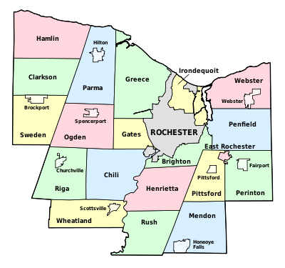 The town, village, and city borders
- Brighton (town)
- Brockport (village)
- Chili (town)
- Churchville (village)
- Clarkson (town)
- East Rochester (village and town)
- Fairport (village)
- Gates (town)
- Greece (town)
- Hamlin (town)
- Henrietta (town)
- Hilton (village)
- Honeoye Falls (village)
- Irondequoit (town)
- Mendon (town)
- Ogden (town)
- Parma (town)
- Penfield (town)
- Perinton (town)
- Pittsford (town)
- Pittsford (village)
- Riga (town)
- Rochester (city)
- Rush (town)
- Scottsville (village)
- Spencerport (village)
- Sweden (town)
- Webster (town)
- Webster (village)
- Wheatland (town)
Colleges and universities
- Colgate Rochester Crozer Divinity School
- Monroe Community College
- Nazareth College (New York)
- Roberts Wesleyan College
- Rochester Institute of Technology
- St. Bernard's School of Theology and Ministry
- St. John Fisher College
- SUNY Brockport
- University of Rochester (including the Eastman School of Music)
Parks
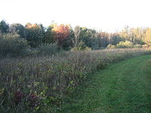 Wetlands Trail in Black Creek Park
- Black Creek Park
- Abraham Lincoln Park
- Churchville Park
- Devil's Cove Park
- Durand-Eastman Park
- Ellison Park
- Genesee Valley Park
- Greece Canal Park
- Highland Park
- Irondequoit Bay Marine Park
- Irondequoit Bay Park West
- Lehigh Valley Trail Park
- Mendon Ponds Park
- Northampton Park
- Oatka Creek Park
- Ontario Beach Park
- Powder Mills Park
- Seneca Park
- Tryon Park
- Webster Park
- Wetlands Park
See also
- Monroe County, New York Sheriff's Office
- List of counties in New York
- National Register of Historic Places listings in Monroe County, New York
References
- ^ "Governing Monroe County: A Staff Report to the Charter Study Commission". Rochester, New York: The Center for Governmental Research. 1974. p. 15. OCLC 21663493
- ^ "Governing Monroe County: A Staff Report to the Charter Study Commission". Rochester, New York: The Center for Governmental Research. 1974. p. 25. OCLC 21663493
- ^ "Monroe County Executive website". http://www.monroecounty.gov/executive-index.php. Retrieved 2008-06-22.
- ^ Monroe County Guide to Local Government. Rochester, New York: Monroe County League of Women Voters. 1986. p. 10. OCLC 13907929
- ^ Monroe County Guide to Local Government. Rochester, New York: Monroe County League of Women Voters. 1986. p. 11. OCLC 13907929
- ^ "Monroe limits legislator terms". Democrat and Chronicle (Rochester, New York): p. 1A. 1993-11-03. ISSN 1088-5153
- ^ Monroe County Guide to Local Government. Rochester, New York: Monroe County League of Women Voters. 1986. p. 10. OCLC 13907929
- ^ "Monroe limits legislator terms". Democrat and Chronicle (Rochester, New York): p. 1A. 1993-11-03. ISSN 1088-5153
- ^ "Eastman Kodak Company information and related industry information from Hoover's". Hoover's, Inc.. 2007. http://www.hoovers.com/eastman-kodak/--ID__10500--/free-co-factsheet.xhtml. Retrieved 2007-04-25.
- ^ "Bausch & Lomb information and related industry information from Hoover's". Hoover's, Inc.. 2007. http://www.hoovers.com/bausch-&-lomb/--ID__10187--/free-co-factsheet.xhtml. Retrieved 2007-04-25.
- ^ "Paychex, Inc. information and related industry information from Hoover's". Hoover's, Inc.. 2007. http://www.hoovers.com/paychex/--ID__14388--/free-co-factsheet.xhtml. Retrieved 2007-04-25.
- ^ "Business briefs" (http://www.democratandchronicle.com/apps/pbcs.dll/article?AID=20107070338). Rochester Democrat and Chronicle. 2010-07-07. "Dick Kaplan announced his resignation as CEO of Pictometry International Corp., the Henrietta-based aerial imaging firm that he has built into one of the Rochester area’s better-known companies."
- ^ "University of Rochester Institute of Optics celebrates its 75th anniversary". SPIE—The International Society for Optical Engineering. 2004. http://oemagazine.com/newscast/2004/101804_newscast01.html. Retrieved 2007-04-25.[dead link]
- ^ "Wegmans Food Markets, Inc. information and related industry information from Hoover's". Hoover's, Inc.. 2007. http://www.hoovers.com/wegmans/--ID__40526--/free-co-factsheet.xhtml. Retrieved 2007-04-25.
- ^ "Roberts Communications, Inc. information and related industry information from Hoover's". Hoover's, Inc.. 2007. http://www.hoovers.com/Roberts-Communications-Inc/--HD__fhhshssft,src__dbi--/free-co-dnb_factsheet.xhtml. Retrieved 2007-04-25.
- ^ Daneman, Matthew (2010-08-06). "PAETEC cuts loss to $7.5M". Democrat and Chronicle. http://www.democratandchronicle.com/apps/pbcs.dll/article?AID=20108060311. Retrieved 2010-08-11. "PAETEC Holding Corp. is edging closer to — but still falling short of — profitability. The Perinton-based telecommunications company reported a loss of $7.5 million for the quarter that ended June 30, an improvement from the $16.5 million it lost in the same quarter a year earlier and from the $9.5 million it lost in the January–March quarter this year."
- ^ "Hickey-Freeman Co., Inc. information and related industry information from Hoover's". Hoover's, Inc.. 2008. http://www.hoovers.com/Hickey-Freeman-Co.,-Inc./--HD__ffttfkxcy,src__dbi--/free-co-dnb_factsheet.xhtml. Retrieved 2008-02-08.
- ^ [1]
- ^ "American FactFinder". United States Census Bureau. http://factfinder.census.gov. Retrieved 2008-01-31.
- ^ "MLA Language Map Data Center: Monroe County, New York". Modern Language Association. 2007. http://www.mla.org/map_data_results&state_id=36&county_id=55&mode=geographic&zip=&place_id=&cty_id=&ll=all&a=&ea=&order=r. Retrieved 2007-04-25.
Further reading
- Sherwood, D.A. (2003). Water resources of Monroe County, New York, water years 1997-99, with emphasis on water quality in the Irondequoit Creek basin : atmospheric deposition, ground water, streamflow, trends in water quality, and chemical loads to Irondequoit Bay [Water-Resources Investigations Report 02-4221]. Ithaca, NY: U.S. Department of the Interior, U.S. Geological Survey.
External links
- Official webpage
- Monroe County at the Open Directory Project
- Monroe County Library System
- Rochester Wiki Monroe County Page
- [2]

Lake Ontario Lake Ontario Lake Ontario Orleans County 
Wayne County  Monroe County, New York

Genesee County Livingston County Ontario County Municipalities and communities of Monroe County, New York City 
Towns Villages Brockport | Churchville | East Rochester | Fairport | Hilton | Honeoye Falls | Pittsford | Scottsville | Spencerport | Webster
CDPs Other
hamletsAdams Basin | Garbutt | Gates Center | Mumford
Categories:- New York counties
- Monroe County, New York
- 1821 establishments in the United States
- Populated places established in 1821
- Rochester, New York metropolitan area


Wikimedia Foundation. 2010.