- New York State Route 390
-
This article is about the current alignment of NY 390. For the former alignment of NY 390 in Seneca County, see New York State Route 390 (1930–1960s).
NYS Route 390
Rochester Outer Loop 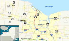
Map of Rochester with NY 390 highlighted in redRoute information Maintained by NYSDOT Length: 8.00 mi[3] (12.87 km) Existed: March 18, 1980[1][2] – present Major junctions South end: 
 I-390 / I-490 in Gates
North end:  Lake Ontario Parkway in Greece
Location Counties: Monroe Highway system Numbered highways in New York
Interstate • U.S. • N.Y. (former) • Reference • County← I-390NY 390A  →
→New York State Route 390 (NY 390) is a north–south state highway located along the western edge of the city of Rochester, New York, in the United States. The route, a limited-access northward continuation of Interstate 390 (I-390), extends for 8.00 miles (12.87 km) from I-490 in Gates to the Lake Ontario State Parkway in Greece, less than 1 mile (1.6 km) from the Lake Ontario shoreline. Between I-490 and NY 104, NY 390 makes up the north–south segment of the northwest quadrant of the Rochester Outer Loop, a series of expressways encircling Rochester. At NY 104, the Outer Loop departs NY 390 and follows NY 104 east into the city.
The freeway was constructed in stages from the 1960s to the 1980s, with the first segment—between I-490 and NY 31—opening to traffic ca. 1963. At the time, it was part of NY 47, which followed the completed portions of the Outer Loop from Gates to Irondequoit. An extension of the freeway north to U.S. Route 104 (US 104; now NY 104) was opened to traffic in the early 1970s. NY 47 was eliminated in 1980, giving way to NY 390 from I-490 to NY 104. NY 390 was extended to its current length in the early 1980s.
Contents
Route description
NY 390 begins at the point where I-390 northbound crosses over I-490 eastbound in the center of a complex interchange between the two in Gates. Due to the setup of the junction, the northbound and southbound roadways, both two lanes wide, are initially set about 250 yards (229 m) apart. The highway heads through the remainder of the exit, passing over the left exit ramp from I-490 west to I-390 south heading northbound and under the ramp linking I-490 east to NY 390 north southbound and crossing over I-490 westbound. North of the junction, the median narrows to a more standard width as NY 390 widens to six lanes and connects to NY 31 (Lyell Avenue). The expressway proceeds north through neighborhoods equally residential and industrial, crossing over both the former right-of-way of the CSX Transportation-owned Falls Road Secondary Track and the Erie Canal prior to meeting Lexington Avenue via a modified trumpet interchange.[4]
 The junction of NY 390 and NY 104 (West Ridge Road) in Greece
From Lexington Avenue, where NY 390 passes into the town of Greece, north to NY 104, NY 390 runs parallel to the western edge of Eastman Business Park, the large production and distribution complex owned and maintained by Eastman Kodak. Midway between the Lexington Avenue and West Ridge Road exits, NY 390 encounters Ridgeway Avenue via a partial diamond interchange.[4] Just north of Ridgeway Avenue, the expressway crosses a small, narrow strip of land that lies within the Rochester city limits, a carryover from when the Erie Canal occupied this tract and entered the city decades before.[5] North of the strip, NY 390 curves to the northeast, passing along the west side of the industrial park and the eastern edge of a residential yet wooded area to reach NY 104. Heading northbound, the is split into two halves, with exit 24A connecting to NY 104 east and exit 24B linking to NY 104 west.[4]
Past NY 104, the roadway surface shifts from pavement to concrete as the freeway heads generally northward through primarily residential neighborhoods. The next exit, with Vintage Lane 1.5 miles (2.4 km) to the north-northeast of NY 104, is the highway's last as a six-lane freeway. Here, it narrows to four lanes—two in both directions—before continuing onward to meet NY 18 (Latta Road) at a conventional diamond interchange. At this point, all commercial vehicles are forced to exit NY 390 due to a similar restriction on the Lake Ontario State Parkway 1 mile (1.6 km) to the north. Outside of a small pocket of development near Greece Arcadia High School, the remainder of the freeway crosses open, sparsely developed areas of Greece. NY 390 curves to the northeast for its final 0.5 miles (0.8 km) before ending at a trumpet interchange with the parkway 1 mile (1.6 km) from the shore of Lake Ontario.[4]
History
The 2-mile (3.2 km) segment of the Rochester Outer Loop between NY 33A and NY 31 was completed ca. 1963.[6][7] It was originally designated as part of NY 47, which had followed the parallel Howard Road to the west prior to the freeway's construction.[8][9] Work on an extension north to US 104 (now NY 104) began in the mid-1960s[9][10] and was completed in the early 1970s.[11][12] The freeway officially became part of NY 47 on January 1, 1970, when the route was extended northward over the then-proposed Outer Loop to a new terminus at the Lake Ontario State Parkway.[13] In actuality, however, NY 47 never extended any farther north than NY 104, which served as the freeway's northern terminus throughout the 1970s.[12][14]
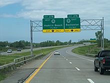 Approaching the Lake Ontario Parkway on NY 390 north
In the late 1970s, the state of New York submitted a proposal to the American Association of State Highway and Transportation Officials that would substantially alter how the Outer Loop was numbered. As part of the plan, the NY 47 designation would be eliminated while the northwestern section of the Outer Loop—from I-490 in Gates to the proposed northern terminus at the Lake Ontario Parkway in Greece—would become the northernmost part of I-390.[2] Most of the proposed changes took effect on March 18, 1980, when NY 47 was eliminated;[1] however, I-390 was modified to end at its junction with I-490. In its place, the Gates–Greece leg of the Outer Loop was assigned NY 390.[15] The NY 390 designation was extended northward to its current terminus in the early 1980s when the segment of the Outer Loop between NY 104 and the Lake Ontario State Parkway was completed.[15][16]
The pair of interchanges connecting NY 390 to I-490 and NY 31 have two major movements that cause weaving. The first is on NY 390 northbound, where traffic entering NY 390 from I-490 west must immediately merge into traffic to avoid taking the NY 31 exit while motorists already on NY 390 must cross traffic coming from I-490 to reach the ramp for NY 31.[17] The other is on NY 390 southbound, where commuters entering NY 390 south from NY 31 must cross several lanes of traffic to access I-490 east.[18] Additionally, the junction between NY 390 / I-390 and I-490 serves over 200,000 cars daily and is often home to traffic jams during the morning and evening rush hours. In July 2010, the New York State Department of Transportation began soliciting ideas on how to improve the junction.[17] Roughly $32 million has been earmarked for a future project to improve the interchange, which is tentatively scheduled to begin in mid-2014.[18]
Exit list
The entire route is in Monroe County.
Location Mile[3] Exit Destinations Notes Gates 0.00 I-390Continuation beyond I-490 20A-B I-490 – Rochester, Buffalo0.48 21  NY 31 (Lyell Avenue)
1.56 22 Lexington Avenue Greece 2.43 23 Ridgeway Avenue 3.57 24A-B  NY 104 (West Ridge Road) – Greece
Single exit 24 southbound 5.29 25 Vintage Lane 6.81 26  NY 18 (Latta Road)
8.00 27A-B Lake Ontario Parkway – Hamlin Beach State ParkNorthbound exit and southbound entrance 1.000 mi = 1.609 km; 1.000 km = 0.621 mi See also
- Interstate 390 for exits 1–19
References
- ^ a b New York State Department of Transportation (January 2009) (PDF). Official Description of Highway Touring Routes, Bicycling Touring Routes, Scenic Byways, & Commemorative/Memorial Designations in New York State. https://www.nysdot.gov/divisions/operating/oom/transportation-systems/repository/2009%20tour-bk.pdf. Retrieved July 16, 2009.
- ^ a b "Numbering State Trunk Highways: A Survey of Methods Used by State DOTs – Appendix A" (PDF). Wisconsin Department of Transportation. April 16, 2008. pp. 62–68. http://on.dot.wi.gov/wisdotresearch/database/tsrs/tsrroutenumbering1.pdf. Retrieved November 18, 2010.
- ^ a b "2008 Traffic Volume Report for New York State" (PDF). New York State Department of Transportation. June 16, 2009. p. 226. https://www.nysdot.gov/divisions/engineering/technical-services/hds-respository/NYSDOT%20TVR%202008%20by%20Route.pdf. Retrieved February 1, 2010.
- ^ a b c d Yahoo! Inc. Yahoo! Maps – overview map of NY 390 (Map). Cartography by NAVTEQ. http://maps.yahoo.com/#mvt=h&lat=43.21476&lon=-77.67339&zoom=13&q1=43.157511%2C-77.679174&q2=43.272014%2C-77.668359. Retrieved November 24, 2010.
- ^ United States Geological Survey (1978). Rochester West Quadrangle – New York (Map). 1:24,000. 7.5 Minute Series (Topographic). http://www.nysgis.state.ny.us/gisdata/quads/drg24/usgspreview/index.cfm?code=o17. Retrieved November 24, 2010.
- ^ Esso (1962). New York with Sight-Seeing Guide (Map). Cartography by General Drafting (1962 ed.).
- ^ Esso (1963). New York Happy Motoring Guide (Map). Cartography by General Drafting (1963 ed.).
- ^ Sinclair Oil Corporation (1962). New York and Metropolitan New York (Map). Cartography by Rand McNally and Company.
- ^ a b Mobil (1965). New York (Map). Cartography by Rand McNally and Company.
- ^ Esso (1968). New York (Map). Cartography by General Drafting (1969–70 ed.).
- ^ State of New York Department of Commerce (1969). New York State Highways (Map). Cartography by Rand McNally and Company.
- ^ a b New York State Thruway Authority (1971). New York Thruway (Map). Cartography by Rand McNally and Company.
- ^ State of New York Department of Transportation (January 1, 1970) (PDF). Official Description of Touring Routes in New York State. http://www.greaternyroads.info/pdfs/state70.pdf. Retrieved July 20, 2010.
- ^ Exxon (1979). New York (Map). Cartography by General Drafting.
- ^ a b Rand McNally and Company (1985). New York (Map). ISBN 0-528-91040-X.
- ^ State of New York (1981). I Love New York Tourism Map (Map). Cartography by Rand McNally and Company.
- ^ a b McDermott, Meaghan M. (July 26, 2010). "DOT seeks input on 490/390 junction". Democrat and Chronicle (Rochester, New York): p. 3B.
- ^ a b Roland, Driadonna (July 28, 2010). "Highway junction problems discussed". Democrat and Chronicle (Rochester, New York): p. 1B.
External links
Categories:- State highways in New York
- Transportation in Rochester, New York
- Limited-access roads in New York


Wikimedia Foundation. 2010.